
Streams
Park geography
A detailed analysis of elevation, volcanic terrain, and regional land coverage
Comprehensive Geographic Profile and Mapped Boundaries of Mount Kaputar National Park
This geographic profile tracks the physical structure of Mount Kaputar National Park in New South Wales. It details the 502.25 square kilometer boundary, high-elevation volcanic peaks such as Mount Kaputar and Mount Dowe, and the surrounding montane forest and temperate environment.
Related tags
Volcanic landscapeSubalpine environmentMountain wildernessEndemic speciesNew South Wales national parks
Ancient volcanic peaks and subalpine wilderness in inland New South Wales
Mount Kaputar National Park
Mount Kaputar National Park is a protected area in northern New South Wales, Australia, centered around the ancient volcanic remnants of Mount Kaputar. The park covers approximately 502 square kilometers of rugged terrain in the Nandewar Range, located about 50 kilometers east of Narrabri and 570 kilometers northwest of Sydney. The park's central peak, Mount Kaputar, rises to 1,510 meters and represents the eroded remains of a volcano that was active between 17 and 21 million years ago. From its summit, visitors can see roughly one-tenth of all New South Wales, an area of approximately 80,000 square kilometers. The park encompasses a remarkable diversity of habitats, ranging from semi-arid woodlands on the lower slopes through eucalypt forests to subalpine heath communities near the peak, making it one of the most ecologically varied protected areas in inland Australia.
- Location
- Australia
- Park type
- National park
- Established
- 1959
- Area
- 502.3 km²
- Highest point
- 1,510 m
Location overview
Regional administrative status within the state of New South Wales
Geographic Positioning of Mount Kaputar National Park in Australia
Mount Kaputar National Park is situated within the state of New South Wales in Australia. As an entirely inland protected area, it operates under a single domestic jurisdiction without coastal or transboundary marine zones.
- Countries
- Australia
- Regions
- New South Wales
- Primary location
- New South Wales
- Geographic setting
- Inland
Boundary and coordinates
Interactive boundary geometry and calculated geographic dimensions
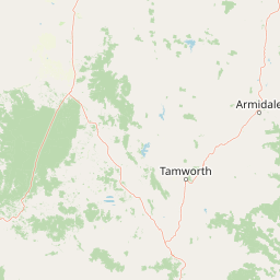
Mount Kaputar National Park Boundary Map and Spatial Extent
The mapped outline provides spatial context for the protected territory through interactive boundary geometry. Accompanying facts detail the measured area, coordinate limits, center point, and geographic spans without legal survey precision.
- Boundary area
- 513.1 km²
- Boundary perimeter
- 335.7 km
- Northernmost point
- 30.0446° S
- Southernmost point
- 30.4798° S
- Easternmost point
- 150.318° E
- Westernmost point
- 149.9829° E
- Geographic centre
- 30.2828° S, 150.1372° E
- North–south span
- 48.2 km
- East–west span
- 32.2 km
Elevation and terrain
Explore recorded peaks, streams, and viewpoints across the high relief landscape
Mount Kaputar National Park Elevation and Mountain Terrain Geography
Recorded elevation data shows a highest point of 1510 meters across the mountain park terrain. Linked feature cards provide names, types, and spatial relationships for natural landmarks within the protected area.
- Maximum elevation
- 1,510 m
- Highest point
- 1,510 m
Selected named natural features
Peaks
Mount Waa
966 m
Viewpoints
Horsearm Creek Lookout
Peaks
Mount Coryah
Viewpoints
Doug Sky Lookout
Peaks
Euglah Rock
Environmental setting
Temperate climate zones, montane forests, and volcanic terrain profiles
Mount Kaputar National Park Environmental Settings and Mountain Classifications
Recorded mountain relief, temperate broadleaf forests, and volcanic landforms serve as interpretive classifications for the physical setting. Associated atlas categories link structured environmental records to related protected-area destinations.
- Relief
- Mountain
- Climate
- Temperate
- Water
- Minor water
- Forest cover
- Partial forest
Landscape features
Mountains · Volcano
Habitat types
Temperate broadleaf forest · Montane forest · Heath
Park atlas
Compare surrounding protected landscapes, regional geography, and conservation zones across northern New South Wales.
Discover Other National Parks and Protected Areas Near Mount Kaputar National Park
Discover other national parks and protected areas near Mount Kaputar National Park, tracing their geographic distribution and environmental context across northern New South Wales. Explore how these conservation landscapes connect, compare their unique features, and understand their regional placement within the wider Australian protected area atlas.
Nature reserveNew South Wales
About 23 km away#1 closest
North

Gamilaroi Nature Reserve: Conservation Landscapes and Rare Woodland Geography in New South Wales
Specialized botanical protection in the inland Brigalow Belt
Gamilaroi Nature Reserve is a compact, science-oriented protected area in the North West Slopes of New South Wales. Defined by its ferruginous sandstone and quartzite substrates, the reserve maintains a distinct ecological blend of belah and white box woodland, serving as a primary site for the conservation of rare native ooline trees.
- Area
- 1.13 km²
- Established
- 1994
- IUCN
- IV
- Relief
- Lowland
National parkNew South Wales
56 km away#2 closest
East
Warrabah National Park: Discover Protected Landscape and Mapped Geography in New South Wales
Explore the geographic context of this Australian national park.
Warrabah National Park is a designated national park in New South Wales, Australia, offering critical insights into protected area geography. This resource details its mapped boundaries and its place within the region's natural landscape. Understand the park's protected land identity and its contribution to the broader geographical atlas, providing a foundation for focused landscape exploration.
- Area
- 34.71 km²
- Established
- 1984
- IUCN
- II
- Relief
- Highland
National parkNew South Wales
84 km away#3 closest
Southwest
Garrawilla National Park: New South Wales Protected Woodland Ecosystems & Regional Geography
Explore mapped boundaries and native vegetation in this inland Australian national park.
Garrawilla National Park represents a significant protected landscape in New South Wales, Australia, dedicated to conserving semi-arid woodland terrain and characteristic native grass communities. Established to safeguard these vital ecosystems, the park offers insights into the natural heritage of the Central West region's geography. Users can explore its specific geographic footprint and understand its contribution to the preservation of inland Australian vegetation, providing a clear picture of its protected area identity.
- Area
- 9.37 km²
- Established
- 2005
- IUCN
- II
- Scope
- Terrestrial
National parkNew South Wales
97 km away#4 closest
East
Indwarra National Park: New South Wales National Park Protected Landscape and Geographic Context
Explore mapped park boundaries and regional geography.
Indwarra National Park is identified as a significant protected area within New South Wales, Australia, offering a unique focus for geographic exploration. As a national park, its mapped boundaries define a distinct natural landscape. This page provides detailed atlas-style information, enabling a deeper understanding of its terrain, regional context, and protected-area significance for structured discovery.
- Area
- 9 km²
- Established
- 1999
- IUCN
- Ia
- Relief
- Mountain
National parkNew South Wales
About 116 km away#5 closest
East
Single National Park National Park: A Protected Landscape within New South Wales
Explore mapped boundaries and regional geography.
Single National Park represents a vital protected area, contributing significantly to the natural landscape of New South Wales. This entry offers a deep dive into its geographic scope, detailing mapped park boundaries and the surrounding regional context. It serves as a foundational piece for understanding the park's identity as a protected natural asset and its place within Australia's broader conservation geography.
- Area
- 25.63 km²
- Established
- 1999
- IUCN
- II
- Relief
- Mixed relief
National parkNew South Wales
121 km away#6 closest
Northeast
Kwiambal National Park: New South Wales National Park with Granite Landscapes and River Confluence
Explore the dramatic scenery of MacIntyre Falls and surrounding protected terrain.
Kwiambal National Park is a significant protected area in New South Wales, Australia, celebrated for its unique granite outcrops and the spectacular confluence of the Severn and Macintyre Rivers at MacIntyre Falls. This national park provides a clear example of regional protected landscape identity, offering valuable context for atlas-driven discovery of Australia's natural geography and mapped terrain. The park's distinctive features contribute to its importance as a conservation reserve within the New England region.
- Area
- 65.17 km²
- Established
- 2000
- IUCN
- II
- Scope
- Terrestrial
National parkOrana
122 km away#7 closest
Southwest
Warrumbungle National Park: Detailed National Park Protected Landscape Atlas Entry
Mapped geography and protected boundaries within Orana, Australia.
Warrumbungle National Park is an Australian national park that serves as a prime example of a protected landscape for atlas-based geographic exploration. This entry provides detailed context on its mapped boundaries and regional terrain, anchoring it within the Orana area. Users can engage with its specific geographic identity, understanding its role as a distinct natural area within Australia's broader conservation atlas and mapped park network.
- Area
- 233.11 km²
- Established
- 1953
- IUCN
- II
- Visitors
- 35K annual
National parkNew South Wales
122 km away#8 closest
Northeast
Kings Plains National Park: National Park Protected Area and Geographic Context
Explore mapped boundaries and landscape details for this New South Wales park.
Kings Plains National Park represents a distinct protected area entity within New South Wales, Australia. This national park serves as a focal point for understanding specific geographic features and its mapped boundaries. Users engaging with this park profile can uncover its regional landscape context and explore its significance as part of a larger atlas of protected natural areas. The focus remains on its geographic identity and atlas-based discovery value.
- Area
- 57 km²
- Established
- 1988
- IUCN
- II
- Access
- Moderate access
MoriAtlas Explorer
Continue Exploring Mount Kaputar National Park's Geographic and Landscape Context
Delve deeper into the mapped terrain and protected-area specifics of Mount Kaputar National Park. Understanding this unique volcanic landscape provides valuable context for New South Wales's broader geography and protected lands network. Discover how its geological past shapes its present ecological diversity through structured geographic data and atlas exploration.
Browse next
Global natural geography
Explore related park routes
Explore MoriAtlas Global ParksBrowse All MoriAtlas ParksGlobal Park Map DiscoveryMoriAtlas: Browse All CountriesBrowse All MoriAtlas ContinentsNational Park Environment AtlasGrand Canyon National Park AtlasYellowstone National Park AtlasYosemite National Park Atlas and GeographySerengeti National Park AtlasGalápagos National Park Protected LandscapeBanff National Park Geography and AtlasKruger National Park Atlas EntryUluṟu-Kata Tjuṯa National Park AtlasExplore Uluru-Kata Tjuta National Park GeographyPlitvice Lakes National Park AtlasFiordland National Park Protected LandscapeGreat Smoky Mountains National Park AtlasAfghanistan National Parks and Protected AreasAlbania National Parks and Protected AreasAlgeria National Parks and Protected AreasAmerican Samoa National Parks and Protected AreasAndorra National Parks and Protected AreasAngola National Parks and Protected AreasAntarctica National Parks and Protected AreasAntigua and Barbuda Park List