
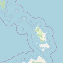
Rivers
Park geography
A comprehensive analysis of Tasmanian lowland terrain, coastal boundaries, and regional geography.
Mount William National Park: Detailed Geographic Profile, Mapped Boundaries, and Natural Features
The geographic profile of Mount William National Park captures its 184.39 square kilometer footprint across the Tasmanian landscape. This analysis details the recorded elevation reaching 216 meters, alongside primary coastal and forest features including Cape Naturaliste, Boulder Point, and the Anson River. The structured data presents the spatial relationship of terrain and water bodies within this temperate protected area.
Related tags
coastal national parksTasmanian wildernessheathland ecosystemsAustralian wildlifesandy beaches
Tasmanian coastal wilderness with sandy beaches and native wildlife
Mount William National Park
Mount William National Park is a protected coastal landscape in northeastern Tasmania, Australia, situated approximately 234 kilometers northeast of Hobart. The park encompasses approximately 184 square kilometers of diverse terrain including coastal dunes, heaths, woodlands, and beaches along the eastern shoreline facing Bass Strait. Established in 1973, the park has grown through multiple expansions and is managed by the Tasmania Parks and Wildlife Service. The park takes its name from Mount William, a 216-meter hill that was officially renamed wukalina in 2016 to honor the local Indigenous heritage. The landscape features several sandy beaches including Stumpys Bay Beach, which provide scenic access to the coast and contrast with the inland heath and scrub communities.
- Location
- Australia
- Park type
- National park
- Established
- 1973
- Area
- 184.4 km²
- Highest point
- 216 m
Location overview
Coastal protected area status in Tasmania, Australia
Mount William National Park Geographic Position in Australia
Mount William National Park is situated as a coastal protected area within Tasmania, Australia. Official territorial records establish its regional alignment alongside its coastal shoreline status.
- Countries
- Australia
- Regions
- Tasmania
- Primary location
- Tasmania
- Geographic setting
- Coastal
Boundary and coordinates
Mount William National Park maps a recorded 184.39 km²
Mount William National Park mapped boundary and 184.39 km² area
Mount William National Park has mapped geometry across its recorded 184.39 km² extent. The outline aids geographic orientation and scale comparison while remaining distinct from official legal boundaries.
- Boundary area
- 185.9 km²
- Boundary perimeter
- 133.7 km
- Northernmost point
- 40.837° S
- Southernmost point
- 41.0682° S
- Easternmost point
- 148.3459° E
- Westernmost point
- 148.0929° E
- Geographic centre
- 40.9651° S, 148.2323° E
- North–south span
- 25.7 km
- East–west span
- 21.3 km
Elevation and terrain
Lowland relief features, coastal capes, and river networks
Mount William National Park Terrain and Elevation Profile
Recorded park elevation reaches a maximum point of 216 meters within the lowland relief classification. Linked feature cards provide names, types, measurements, and spatial relationships for recorded natural features.
- Maximum elevation
- 216 m
- Highest point
- 216 m
Selected named natural features
Capes
Picnic Point
Capes
Boulder Point
Rivers
Cray Creek
Peaks
Wukalina / Mount William
215 m
Islands
Tasmania
Environmental setting
Temperate lowland terrain featuring coastal beaches, grasslands, and broadleaf forest habitats
Mount William National Park Environmental Classification Settings and Protected Landscape Geography
Recorded habitat types and landscape features serve as complementary indicators for reading the physical setting of the protected area. Structured classification categories connect physical terrain profiles to broader regional atlas destinations.
- Relief
- Lowland
- Climate
- Temperate
- Water
- Major water bodies
Landscape features
Hills · Coast · Beach · Forest · Grassland
Habitat types
Grassland · Temperate broadleaf forest
Park atlas
Map the regional spread of protected areas surrounding Mount William National Park, tracing Tasmania's connected coastal and heathland ecosystems
Explore Nearby Protected Areas: Mount William National Park and Surrounding Tasmanian Coastal Landscapes
Browse a curated selection of national parks and protected areas located near Mount William National Park, expanding your understanding of Tasmania's northeastern coastal and inland protected landscapes. Compare their unique geographic features, from expansive sandy beaches to distinct heathland ecosystems, to trace the broader conservation efforts across the region.
Marine protected areaTasmania
25 km away#1 closest
East

Flinders Commonwealth Marine Reserve: Submarine Geography and Deep Seamount Atlas
A protected offshore marine environment in the Tasman Sea
Spanning from shelf waters into the deep ocean, this Commonwealth-managed reserve represents a critical marine protected area off the Tasmanian coast. It features unique benthic environments and prominent seamounts that support diverse deep-sea life far beyond the reach of traditional coastal exploration.
- Area
- 27,043 km²
- Established
- 2007
- IUCN
- II
- Access
- Remote access
National parkAustralia
61 km away#2 closest
Southwest
Ben Lomond National Park: Tasmania's Premier Alpine Protected Landscape & Geography
Explore unique dolerite geology, plateau scenery, and alpine ecosystems.
Ben Lomond National Park is a premier alpine protected area within Australia, known for its dramatic dolerite geology and extensive plateau terrain. This national park offers a distinct mountain landscape shaped by glacial history, featuring notable peaks and significant alpine ecosystems. Discover the mapped boundaries and regional geographic context of this unique Australian protected land, understanding its place within the broader atlas of natural landscapes.
- Area
- 162 km²
- Established
- 1947
- IUCN
- II
- Relief
- Mountain
National parkTasmania
63 km away#3 closest
North
Strzelecki National Park: A National Park in Tasmania's Protected Landscape Atlas
Explore mapped park boundaries and regional terrain.
Strzelecki National Park represents a significant protected land entity within Tasmania, Australia. As a national park, it offers critical insights into the island state's diverse geography and landscape formations. This detailed view supports an atlas-based understanding, highlighting the park's mapped boundaries and its contribution to the structured exploration of Australia's protected areas. Discover the geographic characteristics and contextual importance of this Tasmanian natural landscape.
- Area
- 42.16 km²
- Established
- 1967
- IUCN
- II
- Relief
- Mixed relief
National parkTasmania
66 km away#4 closest
South
Douglas-Apsley National Park: Discover its Protected Landscape and Geographic Context in Tasmania
Mapped boundaries and regional terrain of a key Tasmanian national park.
Delve into the geographic details of Douglas-Apsley National Park, a designated national park situated in Tasmania, Australia. This entry provides insight into the park's protected landscape identity, its mapped boundaries, and its contribution to the rich regional geography of Tasmania. Understanding its place within the island's natural terrain is crucial for comprehensive atlas-driven exploration and appreciating Australia's protected areas.
- Area
- 160.8 km²
- Established
- 1989
- IUCN
- II
- Relief
- Upland
Marine protected areaTasmania
80 km away#5 closest
Southeast
Freycinet Commonwealth Marine Reserve: Protected Marine Landscapes and Bathymetry in the Tasman Sea
Offshore Australian marine geography and deep-sea protected areas
Freycinet Commonwealth Marine Reserve serves as a monumental example of marine conservation in the Tasman Sea. Stretching far from the Tasmanian coast, this reserve protects substantial offshore seamounts and pelagic waters. Its submarine landscape is shaped by ancient volcanic activity, creating varied seafloor environments that support deep-sea biodiversity and wide-ranging marine species.
- Area
- 57,942 km²
- Established
- 2007
- IUCN
- II
- Climate
- Temperate
National parkTasmania
92 km away#6 closest
South
Freycinet National Park: Iconic Granite Peaks and Protected Coastal Landscape in Tasmania
Mapped geography and distinct terrain of Tasmania's historic national park.
Freycinet National Park on Tasmania's east coast is a remarkable protected landscape defined by its dramatic granite mountains, including The Hazards, and the pristine Wineglass Bay. Established as one of Tasmania's first national parks, it showcases unique geological formations and coastal ecosystems across its rugged terrain. This detailed view provides an atlas-style exploration of its mapped boundaries and geographic significance within the regional context.
- Area
- 169 km²
- Established
- 1916
- IUCN
- II
- Visitors
- 200K annual
National parkTasmania
114 km away#7 closest
West
Narawntapu National Park: Tasmania's Coastal Protected Landscape and Wildlife Atlas
Explore mapped boundaries, heathland, woodland, and intertidal bird habitats.
Narawntapu National Park showcases a remarkable protected coastal landscape on Tasmania's north coast, renowned for its exceptional density of marsupial wildlife and significant intertidal bird populations. Its diverse terrain, including heathland, woodland, and extensive mudflats, offers unique opportunities for geographic discovery and understanding the park's ecological importance. Examine its mapped natural features and protected status within the broader atlas of Australian reserves.
- Area
- 43.49 km²
- Established
- 1976
- IUCN
- II
- Visitors
- 10.1K annual
Nature reserveTasmania
About 129 km away#8 closest
Southwest
Liffey Valley Reserve: Geographic Overview of a Tasmania Nature Reserve and Landscape
Protected sclerophyll forest and temperate rainforest sequences
Liffey Valley Reserve in Tasmania provides a focused look at how protected land boundaries align with natural elevation gradients. Its four component parcels protect a complete sequence of Tasmanian vegetation, spanning from ridge-top alpine heath to mossy rainforest depressions. This site acts as a key reference for understanding private conservation geography and the rugged terrain characterizing the eastern edge of the central highlands.
- Area
- 2.75 km²
- Established
- 1991
- Water
- Major water bodies
- Season
- Year-round
MoriAtlas Explorer
Continue Exploring Mount William National Park's Geographic and Protected Landscape Identity
Delve deeper into the mapped terrain and protected area specifics of Mount William National Park. Understanding this national park's unique geographic signature within Tasmania is key to appreciating Australia's expansive natural landscapes and conservation efforts. This route supports structured discovery of protected lands and their regional atlas context.
Browse next
Global natural geography
Explore related park routes
Explore MoriAtlas Global ParksBrowse All MoriAtlas ParksGlobal Park Map DiscoveryMoriAtlas: Browse All CountriesBrowse All MoriAtlas ContinentsNational Park Environment AtlasGrand Canyon National Park AtlasYellowstone National Park AtlasYosemite National Park Atlas and GeographySerengeti National Park AtlasGalápagos National Park Protected LandscapeBanff National Park Geography and AtlasKruger National Park Atlas EntryUluṟu-Kata Tjuṯa National Park AtlasExplore Uluru-Kata Tjuta National Park GeographyPlitvice Lakes National Park AtlasFiordland National Park Protected LandscapeGreat Smoky Mountains National Park AtlasAfghanistan National Parks and Protected AreasAlbania National Parks and Protected AreasAlgeria National Parks and Protected AreasAmerican Samoa National Parks and Protected AreasAndorra National Parks and Protected AreasAngola National Parks and Protected AreasAntarctica National Parks and Protected AreasAntigua and Barbuda Park List