

Mori Atlas logo
National parkMu Ko Surin National Park

Explore the mapped boundaries and diverse geography of this island national park.

Mu Ko Surin National Park: Thailand's Marine Protected Landscape and Atlas Discovery

Mu Ko Surin National Park, a significant marine protected area in Thailand, offers a unique exploration of island geography and vibrant aquatic ecosystems. This national park encompasses a cluster of islands within the Andaman Sea, showcasing dense tropical vegetation on land and extensive, biologically rich coral reef systems underwater. As an integral part of Thailand's protected natural landscapes, the park provides a detailed geographic context for understanding coastal biodiversity and marine conservation efforts.

Marine National ParkCoral ReefsIslandsAndaman SeaSnorkelingDiving

Mu Ko Surin National Park

National park

Park overview

Structured park overview, official facts, and landscape profile for Mu Ko Surin National Park

Mu Ko Surin National Park park facts, protected area profile, and essential visitor context

Review the core facts for Mu Ko Surin National Park, including designation, size, terrain, visitor scale, habitats, and operating context in one park-focused overview.

About Mu Ko Surin National Park

Mu Ko Surin National Park represents one of Thailand's most important marine protected areas, guarding a chain of islands in the Andaman Sea that harbor exceptional ecological value. The park lies approximately 60 kilometers offshore from the mainland coast of Phang Nga Province, placing it in a relatively remote position that has helped preserve its natural state. The five main islands that make up the Surin Islands group feature steep interior hillsides covered in evergreen forest, contrasting with the more disturbed vegetation patterns seen on many developed Thai islands. Coastal areas transition from rocky headlands to small sand beaches, with coral reefs beginning at the shoreline and extending outward in some locations. The surrounding seas maintain stable water temperatures year-round, supporting consistent coral growth and marine productivity. The park's establishment in 1992 reflected growing recognition that Thailand's marine resources faced mounting pressures from tourism, fishing, and coastal development. Management efforts have focused on balancing limited visitor access with habitat protection, recognizing that the islands' ecological integrity depends on maintaining healthy marine ecosystems. Visitor facilities remain modest compared to more developed island destinations, with overnight accommodations available but limited in capacity.

Quick facts and research context for Mu Ko Surin National Park

Mu Ko Surin National Park is located in the Andaman Sea off the coast of Phang Nga Province in southern Thailand, comprising a group of islands known collectively as the Surin Islands. The park was established in 1992 and covers both terrestrial and marine areas, with the surrounding waters forming a significant portion of the protected ecosystem. The islands feature forested hillsides that descend to rocky and sandy shorelines, with coral reefs fringing the coastline. The marine environment supports high fish diversity, sea turtles, and seasonal plankton blooms that attract whale sharks. The park operates seasonal visitor facilities and maintains limits on daily visitors to protect the sensitive marine environment.

Protection and recognition

Documenting marine boundaries and official management status for the island archipelago

Official Protection Status and Marine Conservation Designation of Mu Ko Surin National Park

National park databases record Mu Ko Surin National Park as a dedicated marine protected area established to conserve critical coastal and aquatic environments. Accessing verified registry details provides essential geographic context regarding official designation history and marine conservation management scopes.

Protection details

Protection scope
Marine
Park context

Deeper park guide and search-rich context for Mu Ko Surin National Park

Mu Ko Surin National Park history, landscape, wildlife, and travel context

Explore Mu Ko Surin National Park through its history, landscape character, ecosystems, wildlife, conservation priorities, cultural context, and seasonal travel timing in a structured park guide built for atlas discovery and search intent.

Why Mu Ko Surin National Park stands out

Mu Ko Surin National Park is best known for its exceptional marine biodiversity and well-preserved coral reef systems. The surrounding waters host more than 200 species of coral and diverse fish populations, making it a premier snorkeling and diving destination in Thailand. The park is particularly famous for regular sightings of whale sharks, which visit the area during certain times of year. Sea turtles, including green turtles and hawksbill turtles, nest on the islands' beaches. On land, the islands feature old-growth tropical forest with towering trees and dense undergrowth, providing habitat for resident and migratory bird species.

Mu Ko Surin National Park history and protected-area timeline

Mu Ko Surin National Park was officially designated as a national park on July 31, 1992, becoming part of Thailand's growing system of marine protected areas during a period of increasing environmental awareness in the country. The establishment came amid growing concern about the degradation of coral reefs and marine habitats along the Andaman coast, where tourism development had accelerated rapidly during the preceding decade. Prior to national park designation, the islands had received some protection as part of a wildlife sanctuary, but the elevated protected status provided stronger legal framework for conservation. The decision to include both the islands and surrounding marine waters reflected evolving understanding that effective marine conservation requires protecting entire ecosystems rather than isolated habitats. Initial management focused on establishing visitor facilities and developing sustainable tourism frameworks that would allow some public access while preventing damage to sensitive coral areas. The park has since become a model for how limited, well-managed tourism can coexist with conservation objectives in marine environments.

Mu Ko Surin National Park landscape and geographic character

The Surin Islands feature a dramatic landscape defined by the transition from forested hillsides to coastal waters. The interior of the larger islands reaches elevations approaching 300 meters, with steep-sided ridges covered in dense tropical vegetation. The forest canopy includes tall trees such as dipterocarps and pandanus, with dense undergrowth of ferns and shrubs creating a layered forest structure. Along the coast, rocky promontories alternate with small sandy coves, and the islands' western shores generally feature wider beach areas than the eastern sides. Below the waterline, the islands are surrounded by coral reef platforms that vary in width and development depending on local conditions. Some reef areas extend several hundred meters from shore, while in other locations the reef begins almost immediately at the coastline. The underwater terrain slopes gradually from the reef flats to deeper water, with scattered rocky outcrops and sand channels providing habitat diversity. The surrounding seafloor consists primarily of sand and mud in deeper areas, with coral growth concentrated on the shallower reef platforms.

Mu Ko Surin National Park ecosystems, habitats, and plant life

The marine environment of Mu Ko Surin National Park supports one of the most biodiverse ecosystems in Thai waters. Coral reefs cover substantial areas around the islands, with more than 200 coral species identified in the park's boundaries. These reefs support dense populations of reef fish, including surgeonfish, butterflyfish, parrotfish, and groupers, along with numerous invertebrate species including sea stars, sea urchins, and various shellfish. The waters around the Surin Islands serve as important habitat for sea turtles, with both green turtles and hawksbill turtles regularly observed in the area. The islands also provide nesting beaches for green turtles, with nesting activity concentrated on specific beaches during the appropriate season. Seasonal visitors to the marine environment include whale sharks, which appear reliably during the months when plankton concentrations are highest in the Andaman Sea. The terrestrial forest supports resident bird populations including hornbills, kingfishers, and various passerine species, while migratory birds use the islands as stopover points during their seasonal movements.

Mu Ko Surin National Park wildlife and species highlights

The wildlife of Mu Ko Surin centers on its marine fauna, which draws the majority of visitor interest to the park. Sea turtles represent the most iconic marine species, with green turtles and hawksbill turtles commonly encountered while snorkeling or diving. These turtles feed on seagrass beds and reef organisms, and the park's protected status helps ensure their continued presence in what would otherwise be heavily fished waters. The reef systems host extraordinary fish diversity, with numerous species present in quantities that exceed what is typically seen in more heavily used coastal areas. Seasonal whale shark visits have become a major attraction, with these large filter-feeding animals appearing reliably enough that many dive operators schedule trips specifically to coincide with likely sighting periods. The islands' forested areas provide habitat for several bird species, including the great hornbill which can be spotted in the tree canopy. terrestrial reptiles including monitor lizards and geckos inhabit the islands, while the surrounding waters host occasional dolphin sightings and seasonal appearances of other marine mammals.

Mu Ko Surin National Park conservation status and protection priorities

Mu Ko Surin National Park serves as a critical refugia for marine species in the Andaman Sea region, protecting reef systems and coastal habitats that would otherwise face significant degradation from fishing pressure and coastal development. The park's marine protected area status restricts destructive fishing practices within its boundaries and limits the extraction of marine resources. Visitor numbers are managed to prevent the cumulative impacts that have damaged coral reefs at more heavily visited destinations, and the park maintains specific codes of conduct for snorkeling and diving activities to minimize physical damage to corals. The protection of sea turtle nesting beaches ensures that these species have secure sites for reproduction, addressing a major conservation concern for turtle populations throughout Southeast Asia. The presence of whale sharks, which are vulnerable to boat strikes and disturbance, benefits from the reduced vessel traffic in the protected waters. The park demonstrates that marine conservation can accommodate limited sustainable tourism, providing a model for balancing ecological protection with human use of marine environments.

Mu Ko Surin National Park cultural meaning and human context

The Surin Islands have historical connections to the indigenous Moken people, also known as sea nomads, who traditionally lived throughout the Andaman Sea region. The Moken historically used the islands as temporary camps during their seasonal movements through the archipelago, and some historical evidence of their presence remains on the islands. The name Surin itself derives from Thai and Burmese heritage, reflecting the cultural influences that have shaped the region's identity over centuries. The islands are located in a maritime zone that has served as a navigation corridor and fishing ground for coastal communities throughout historical time, though their offshore position limited intensive human settlement. Modern management of the park maintains awareness of these cultural connections while focusing primarily on ecological conservation objectives.

Top sights and standout views in Mu Ko Surin National Park

The exceptional coral reefs surrounding the Surin Islands represent one of the finest snorkeling and diving experiences available in Thailand, with healthy coral cover and abundant marine life. Regular whale shark sightings during the optimal season draw dedicated marine wildlife enthusiasts to the park. The islands' relatively remote location and limited visitor capacity preserve a sense of wilderness that contrasts with more developed island destinations. Sea turtle nesting beaches provide opportunities to observe these endangered animals in their natural habitat. The old-growth forest on the islands' interiors offers terrestrial exploration opportunities, with hiking trails leading to viewpoints overlooking the archipelago.

Best time to visit Mu Ko Surin National Park

The optimal time to visit Mu Ko Surin National Park spans from November through April, when monsoon conditions have passed and the Andaman Sea exhibits calm seas and excellent underwater visibility. This dry season period typically offers water clarity exceeding 20 meters, providing ideal conditions for snorkeling and diving activities. The cool season temperatures make outdoor activities comfortable, though conditions can become crowded during peak holiday periods. The whale shark season peaks between March and May, when plankton blooms attract these large animals to the area, though sightings occur throughout the broader dry season. The monsoon season from May through October brings rough seas and reduced visibility, and many park operations scale back or close during this period. Visiting during shoulder seasons of November or April can offer a balance between favorable conditions and reduced crowding.
Monthly climate preview

Long-term representative temperature and precipitation patterns across the year

Mu Ko Surin National Park Climate Normals and Monthly Weather Records

Mu Ko Surin National Park exhibits a measured annual temperature range from 26.72 °C to 28.81 °C alongside varying monthly precipitation rates recorded between 1991 and 2020. Examining the complete twelve-month climatology profile provides deeper analytical insight into representative temperature distributions and rainfall rhythms.
Annual mean28 °C
27 °C29 °C
Jan27°
Feb27°
Mar28°
Apr29°
May28°
Jun28°
Jul27°
Aug27°
Sep27°
Oct27°
Nov27°
Dec27°
Warmest month
April

28.8 °C

Coolest month
January

26.7 °C

Wettest month
September

15.5 mm/day

Driest month
February

1 mm/day

Park location guide

Geography guide, regional context, and park location map for Mu Ko Surin National Park

Mu Ko Surin National Park park geography, regions, and map view in Thailand

Understand where Mu Ko Surin National Park sits in Thailand through a broader geographic reading of the surrounding landscape, nearby location context, and its mapped position within the national park landscape.

How Mu Ko Surin National Park fits into Thailand

Thailand is a Southeast Asian nation formerly called Siam, located in mainland Southeast Asia. It operates as a unitary parliamentary constitutional monarchy under King Vajiralongkorn. The country borders Myanmar, Laos, Cambodia, and Malaysia, with maritime boundaries involving Vietnam, Indonesia, and India. Thailand has a population of nearly 66 million and covers approximately 513,120 km². Historically, the Sukhothai Kingdom marks the beginning of Thai history, followed by the powerful Ayutthaya Kingdom.

Wider geography shaping Mu Ko Surin National Park in Thailand

Thailand occupies mainland Southeast Asia with borders to Myanmar (west/northwest), Laos (east/northeast), Cambodia (southeast), and Malaysia (south). The country has coastline along the Gulf of Thailand to the southeast and the Andaman Sea to the southwest. The territory covers approximately 513,120 km².

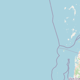
Map view of Mu Ko Surin National Park

Use this park location map to pinpoint Mu Ko Surin National Park in Thailand, understand its exact geographic position, and read its mapped placement within the surrounding landscape more clearly.

Pigeon | © OpenStreetMap contributors
Park atlas

Browse the surrounding protected landscapes and marine ecosystems, tracing the geographic context of Mu Ko Surin National Park's islands.

Explore Nearby National Parks and Protected Areas Around Mu Ko Surin National Park, Thailand

Continue your exploration beyond Mu Ko Surin National Park by browsing other national parks and marine protected areas situated throughout Thailand's Andaman Sea. Compare their unique island geographies, diverse marine ecosystems, and distinct conservation strategies to deepen your understanding of the region's protected landscapes.
National parkRanong
About 69 km away#1 closest

East

Laem Son National Park: A Protected National Park in Ranong's Geographic Landscape

Explore the mapped natural terrain and protected area boundaries.

Laem Son National Park is a key protected area within Thailand's Ranong province, offering valuable insights into regional geography and landscape preservation. This entry focuses on its status as a national park, providing a structured view of its protected boundaries and environmental context. Understand its unique position within the mapped geography, vital for any comprehensive atlas exploration of protected lands in the region.

Area
315 km²
Established
1983
IUCN
II
Visitors
21.9K annual
National parkPhang Nga Province
About 73 km away#2 closest

Southeast

Si Phang-nga National Park: Protected Landscape Identity and Geographic Context in Phang Nga

Explore the park's mapped boundaries and unique karst landscape.

Si Phang-nga National Park stands as a key protected area, distinguished by its extraordinary limestone karst formations that dominate the coastal geography of Phang Nga Province, Thailand. The park's protected landscape features include dramatic pinnacles rising from mangrove-lined waters and intricate cave systems with archaeological significance. Delve into the unique natural terrain and map context that define this vital national park, offering a deep dive into its geological history and ecological importance.

Area
246 km²
Established
1988
IUCN
II
Visitors
21.3K annual
Watercolor illustration of a coastal landscape with rolling hills, green vegetation, pink flowers, and a body of water in the background
National parkThailand
About 88 km away#3 closest

South

Mu Ko Similan National Park: Thailand's Andaman Sea Marine National Park and Archipelago Geography

Mapped island terrain, coral reef atlas, and marine protected landscape identity.

Mu Ko Similan National Park is a significant protected area in Thailand, renowned for its island archipelago geography in the Andaman Sea. The park features striking granite boulder formations above sea level and incredibly rich coral reef ecosystems below, making it a key location for marine atlas exploration. Users can discover the mapped park boundaries, the unique natural terrain of the Similan Islands, and the vital role of this protected landscape in regional marine conservation efforts, offering a detailed geographic perspective.

Area
140 km²
Established
1982
IUCN
II
Visitors
912K annual
National parkSurat Thani Province
About 90 km away#4 closest

Southeast

Khao Sok National Park: Protected Landscape Atlas and Geographic Detail

Explore mapped boundaries and regional terrain in Surat Thani Province.

Khao Sok National Park represents a crucial protected landscape within the expansive geography of Surat Thani Province, Thailand. This detailed entry focuses on the park's identity as a national park, emphasizing its mapped boundaries and the surrounding natural terrain. Through structured information and geographic context, users can gain a clear understanding of Khao Sok National Park's place in the atlas, contributing to a more informed approach to landscape discovery.

Area
739 km²
Established
1980
IUCN
II
Visitors
419.5K annual
National parkPhang Nga Province
About 92 km away#5 closest

Southeast

Khao Lak, Lam Ru National Park: Protected National Park Landscape and Geography

Explore its mapped boundaries and regional context in Phang Nga Province.

This entry focuses on Khao Lak, Lam Ru National Park, a designated national park offering a distinct protected landscape within Phang Nga Province, Thailand. It provides structured data and map context crucial for understanding its geographic scope and regional significance. Explore the park's mapped boundaries, its role as a protected area, and its contribution to the broader landscape of southern Thailand, fostering a deeper appreciation for its natural geography and atlas-derived insights.

Area
125 km²
Established
1991
IUCN
II
Visitors
72.2K annual
National parkSurat Thani Province
About 110 km away#6 closest

Southeast

Khlong Phanom National Park: Protected National Park in Surat Thani Province, Southern Thailand

Discover its mapped boundaries and regional landscape context.

Khlong Phanom National Park is a designated national park providing valuable insight into the natural geography of Surat Thani Province. This protected landscape serves as a key entity for understanding regional terrain and the distribution of conservation areas in Southern Thailand. Explore its mapped geographic features and protected boundaries to gain a structured understanding of its place within the national park atlas.

Area
410 km²
Established
2000
IUCN
II
Visitors
1.7K annual
National parkSurat Thani Province
About 111 km away#7 closest

East

Kaeng Krung National Park: Exploring Protected Area Boundaries and Regional Geography

A National Park within Surat Thani Province's diverse landscapes.

Kaeng Krung National Park is a distinct protected area situated in Surat Thani Province, Thailand. This page provides essential context for understanding the park's geographic significance, its mapped boundaries, and its contribution to the regional protected landscape atlas. Explore the fundamental geographic characteristics that define this important natural reserve and its surrounding terrain.

Area
541 km²
Established
1991
IUCN
II
Visitors
909 annual
National parkPhang Nga Province
About 117 km away#8 closest

South

Khao Lampi, Hat Thai Mueang National Park: Mountain Rainforest and Andaman Coast Atlas

Explore the mapped geography and protected boundaries.

Delve into Khao Lampi, Hat Thai Mueang National Park, a key protected area within Phang Nga Province, Thailand. This unique national park showcases a striking dichotomy: the lush, waterfall-adorned slopes of the Khao Lampi mountains contrast with the pristine Andaman Sea coastline of Hat Thai Mueang beach, a critical site for sea turtle nesting. The park's mapped landscape encompasses dense tropical rainforest, significant mangrove ecosystems, and important natural terrain, offering a comprehensive view of diverse protected environments for atlas exploration.

Area
72 km²
Established
1986
IUCN
II
Visitors
50.5K annual

Common questions about visiting, size, designation, and location context for Mu Ko Surin National Park

Mu Ko Surin National Park FAQs for park facts, access, geography, and protected area context

Find quick answers about Mu Ko Surin National Park, including protected-area facts, park geography, trail and visitor context, and how the park fits into its surrounding country and regional landscape.
MoriAtlas Explorer

Continue Your Protected Areas Search Across the Global Atlas

Deepen your exploration by continuing the structured search for national parks and protected areas worldwide. Utilize the comprehensive filtering capabilities to compare different conservation landscapes and refine your understanding of global park geography. Discover more about the distribution and characteristics of protected natural areas.

Global natural geography