Mori Atlas logo
National parkMukurthi National Park

Discover the unique shola-grassland ecosystem and its critical role in conserving the Nilgiri tahr.

Mukurthi National Park: Protected Landscape and Montane Geography in Nilgiri District

Mukurthi National Park in India's Nilgiri District stands as a vital protected area, meticulously preserving a unique montane landscape characterized by rolling grasslands and dense shola forest patches. Established to safeguard the endangered Nilgiri tahr, this national park represents a crucial component of the Western Ghats UNESCO World Heritage Site, showcasing a distinct ecosystem found nowhere else on Earth. Users can explore its high-elevation terrain, mapped park boundaries, and the geographic context that defines this significant conservation landscape.

National ParkWestern GhatsUNESCO World Heritage SiteNilgiri tahrShola-grassland ecosystemMontane grasslands

Mukurthi National Park

National park

Park overview

Structured park overview, official facts, and landscape profile for Mukurthi National Park

Mukurthi National Park park facts, protected area profile, and essential visitor context

Review the core facts for Mukurthi National Park, including designation, size, terrain, visitor scale, habitats, and operating context in one park-focused overview.

About Mukurthi National Park

Mukurthi National Park occupies a crescent-shaped tract in the southwestern portion of the Nilgiri Plateau, spanning coordinates approximately 11°10' to 11°22' north latitude and 76°26' to 76°34' east longitude. The park's location at the intersection of Tamil Nadu and Kerala makes it a critical corridor for wildlife movement between the Nilgiri hills and the adjacent Silent Valley ecosystem. The protection of this area was motivated by the precarious status of the Nilgiri tahr population, which had declined dramatically due to habitat degradation from plantation expansion and grazing pressure. Beyond its conservation mandate for the tahr, the park shelters significant populations of Bengal tigers and Asian elephants, two flagship species of Indian wilderness. The harsh environmental conditions, including extreme rainfall and temperatures that occasionally drop below freezing, have historically limited human settlement in the area, allowing relatively intact ecosystems to persist despite colonial-era resource extraction. Management priorities focus on restoring degraded plantations to native grassland habitat, controlling invasive species such as wattle and eucalyptus, and maintaining anti-poaching efforts to protect vulnerable wildlife populations.

Quick facts and research context for Mukurthi National Park

Mukurthi National Park lies in the Nilgiri District of Tamil Nadu at elevations ranging from 1,500 to 2,629 metres above sea level. The park contains several prominent peaks including Kollaribetta at 2,629 metres, Mukurthi Peak at 2,554 metres, and Nilgiri Peak at 2,476 metres. Annual rainfall varies dramatically across the park, ranging from 2,010 to 6,330 millimetres. The protected area is bordered by multiple forest divisions and shares a 39-kilometre boundary with Kerala to the southwest, where it abuts Silent Valley National Park. Key rivers including the Billithadahalla, Pykara, and Kundah traverse the park, feeding the Upper Bhavani and Mukurthi reservoirs.

Protection and recognition

Analyzing documented conservation history, terrestrial management scope, and regional boundary frameworks.

Mukurthi National Park Protection Status and Official Terrestrial Designation

Established as a protected terrestrial area in 2012, Mukurthi National Park forms a critical part of the regional conservation network. Exploring verified management frameworks helps researchers and conservationists trace the formal legal status and regional boundary alignments.

Protection details

Protection scope
Terrestrial
Designated year
2012
Transboundary protection
No
Park context

Deeper park guide and search-rich context for Mukurthi National Park

Mukurthi National Park history, landscape, wildlife, and travel context

Explore Mukurthi National Park through its history, landscape character, ecosystems, wildlife, conservation priorities, cultural context, and seasonal travel timing in a structured park guide built for atlas discovery and search intent.

Why Mukurthi National Park stands out

Mukurthi National Park is best known as the primary refuge of the Nilgiri tahr, a critically endangered mountain ungulate found only in the high-elevation grasslands of the Western Ghats. The park protects one of the last remaining tracts of intact shola-grassland ecosystem, a unique habitat type characterized by montane grasslands dotted with evergreen shola forest patches. This dual ecosystem supports exceptional biodiversity and represents a conservation landscape of global significance. The park's designation as part of the UNESCO World Heritage Western Ghats reflects its outstanding universal value as one of the most significant biodiversity hotspots on Earth.

Mukurthi National Park history and protected-area timeline

The history of Mukurthi National Park reflects the broader trajectory of forest management and conservation in the Nilgiri Hills. Indigenous hill communities including the Toda people have inhabited these mountains for centuries, traditionally harvesting firewood from shola forests and grazing their hill buffalo on the grasslands. The establishment of British settlements in Ootacamund, Coonoor, and Wellington in the early nineteenth century initiated a period of extensive shola clearance. Beginning in 1841, authorities issued contracts for commercial timber extraction under a timber conservancy program, and by 1868, officials were already expressing concern about the accelerating destruction of shola ecosystems. Between 1840 and 1856, extensive plantations of non-native species including various wattle species, eucalyptus, cypress, and pine were established to meet fuelwood demands. These exotic plantations, particularly the wattles, spread aggressively through root suckers and became invasive. The entire area was declared a Reserve Forest in 1886, and in 1920, proposals called for replacing remaining sholas with exotic monocultures. The area received formal protected status as a wildlife sanctuary on 3 August 1982 and was upgraded to National Park status on 15 October 1990 to provide stronger protection for the Nilgiri tahr.

Mukurthi National Park landscape and geographic character

Mukurthi National Park presents a dramatic highland landscape dominated by the Kundah range of the Nilgiri Hills. The terrain is characterized by a series of steep peaks rising above the general plateau level, with Kollaribetta, Mukurthi Peak, and Nilgiri Peak forming the most prominent summits. The southwestern portion of the park contains additional notable peaks including Sispara at 2,206 metres, Anginda at 2,383 metres, and Gulkal at 2,468 metres. The park's elongated crescent shape faces westward, with elevations varying from 1,500 metres in the lower valleys to 2,629 metres at the highest summits. The landscape is punctuated by several perennial streams and rivers including the Billithadahalla, Pykara, and Kundah, which drain eastward and ultimately feed the Bhavani River system. The Upper Bhavani and Mukurthi reservoirs within the park represent significant hydrological features. The environment is harsh, with annual rainfall ranging from 2,010 to 6,330 millimetres and wind speeds that can exceed 120 kilometres per hour during storms.

Mukurthi National Park ecosystems, habitats, and plant life

The ecological character of Mukurthi National Park is defined by its unique shola-grassland association, a landscape found exclusively in the high elevations of the Western Ghats. Montane grasslands dominate the exposed slopes and plateaus, while shola forests occupy the sheltered ravines and valleys, creating a distinctive mosaic of habitat types. The park supports exceptional plant endemism, particularly among the scapigerous annual Impatiens species. The shola forests contain numerous evergreen species including Rhododendron trees, with Rhododendron arboreum and Rhododendron nilagiricum producing conspicuous displays throughout the grasslands. Additional shola species include Syzygium calophyllifolium, Daphniphyllum neilgherrense, Cinnamomum wightii, and Mahonia leschenaultia. The forest edges support diverse shrubs including Gaultheria fragrantissima, Rhodomyrtus tomentosa, and various Rubus species. The park's orchid diversity includes species such as Eria abliflora, Aerides crispa, and Coelogyne odoratissima. Approximately 20 percent of the park currently provides suitable habitat for Nilgiri tahr, though restoration of degraded plantation areas could increase usable habitat to 60 percent.

Mukurthi National Park wildlife and species highlights

Mukurthi National Park supports a remarkable diversity of threatened mammal species centered on the endangered Nilgiri tahr, which reaches its northern range limit in this park. A 2007 census recorded approximately 200 tahrs including 60 young individuals. Other significant mammals include the Bengal tiger, Asian elephant, Nilgiri marten, and Nilgiri langur. The park supports populations of leopard, sambar deer, barking deer, mouse deer, otter, jungle cat, small Indian civet, wild dog, jackal, and various smaller mammals including Bonhote's mouse, Malabar spiny dormouse, and soft-furred rat. The avifauna includes several endemic hill birds such as the Nilgiri laughingthrush, Malabar whistling thrush, Nilgiri wood pigeon, black-and-orange flycatcher, and Nilgiri pipit. Predatory birds including black-winged kite, common kestrel, and black eagle hunt the grasslands. The reptile fauna includes endemic species such as the geckos, Nilgiri salea, and various shieldtail snakes including Perrotet's shieldtail. Amphibian diversity is exceptionally high with numerous endemic frog species including several Raorchestes species and the distinctive dancing frog.

Mukurthi National Park conservation status and protection priorities

Mukurthi National Park represents a critical conservation landscape within the Western Ghats biodiversity hotspot. The park's primary conservation purpose is the protection of the Nilgiri tahr, a species that has suffered severe population declines due to habitat fragmentation and competition with livestock. The shola-grassland ecosystem is itself of outstanding conservation value, representing a rare and threatened habitat type of global significance. The park's inclusion in the Nilgiri Biosphere Reserve and its designation as part of the UNESCO World Heritage Site acknowledges its irreplaceable ecological value. Management challenges include controlling invasive exotic species such as wattle and eucalyptus that were planted during the colonial period and have spread extensively into native grasslands. Restoration efforts aim to remove these plantations and rehabilitate approximately 60 percent of the park area as tahr habitat. The park operates year-round anti-poaching programs and maintains fire management protocols during the December to April fire season.

Mukurthi National Park cultural meaning and human context

The lands now within Mukurthi National Park have long been inhabited by indigenous hill communities, particularly the Toda people, who have maintained traditional pastoral practices in the highland grasslands for centuries. The Toda traditionally grazed hill buffalo in the shola-grassland environment and harvested firewood from the forest patches. Historical routes through the park, including the old Sispara ghat road from Kozhikode to Ooty constructed in 1832, connected the Nilgiri Plateau to the west coast. Bangitappal at the southwest end of the park served as a historic halting place on this route and was also associated with smuggling activities involving cannabis, tobacco, and salt during the nineteenth century. The cultural landscape bears the imprint of colonial forest management practices, particularly the extensive plantation of exotic species that now pose restoration challenges.

Top sights and standout views in Mukurthi National Park

Mukurthi National Park offers one of the most significant high-elevation wilderness experiences in South India, protecting the last strongholds of the endangered Nilgiri tahr in its natural shola-grassland habitat. The park's dramatic mountain scenery, with peaks rising above 2,500 metres, provides spectacular trekking opportunities through relatively undisturbed montane ecosystems. The opportunity to observe Nilgiri tahr in their natural habitat, alongside other endemic species including the Nilgiri langur and Nilgiri marten, makes this park particularly significant for wildlife enthusiasts and researchers. The park's UNESCO World Heritage status as part of the Western Ghats underscores its global importance as a biodiversity hotspot of outstanding universal value.

Best time to visit Mukurthi National Park

The optimal seasons for visiting Mukurthi National Park are February through May and September through November, when weather conditions are most favorable for trekking and wildlife observation. The monsoon season from June to September brings heavy rainfall that can exceed 6,000 millimetres annually, making trails treacherous and visibility poor. The winter months from December to January can bring near-freezing temperatures, particularly at higher elevations, and the dry season from December to April creates elevated fire risk that may affect access. Visitors should note that casual tourism is not permitted and all access requires special permission through the Tamil Nadu Department of Forestry, typically arranged through organized trekking programs.

Monthly climate preview

Long term temperature averages and seasonal precipitation cycles in Nilgiri District

Mukurthi National Park Climate Patterns and Monthly Weather Normals

Long-term records highlight a temperature profile peaking above 35 degrees Celsius alongside precipitation patterns that vary widely by month. Accessing the twelve-month climatology provides a comprehensive view of historical precipitation averages and temperature fluctuations across the protected area.
Annual mean23 °C
21 °C27 °C
Jan22°
Feb25°
Mar27°
Apr27°
May25°
Jun23°
Jul22°
Aug22°
Sep22°
Oct23°
Nov22°
Dec21°
Warmest month
April

26.9 °C

Coolest month
December

21.3 °C

Wettest month
June

13.5 mm/day

Driest month
January

0.1 mm/day

Park location guide

Geography guide, regional context, and park location map for Mukurthi National Park

Mukurthi National Park park geography, regions, and map view in India

Understand where Mukurthi National Park sits in India through a broader geographic reading of the surrounding landscape, nearby location context, and its mapped position within the national park landscape.

How Mukurthi National Park fits into India

India is a South Asian country bordered by the Indian Ocean, Arabian Sea, and Bay of Bengal. It shares land borders with Pakistan, China, Nepal, Bhutan, Bangladesh, and Myanmar. The country has a population of over 1.4 billion people and operates as a federal parliamentary republic with its capital in New Delhi.

Wider geography shaping Mukurthi National Park in India

India occupies the Indian subcontinent in South Asia, bordered by the Arabian Sea to the southwest, the Bay of Bengal to the southeast, and the Indian Ocean to the south. It shares land borders with Pakistan to the west, China, Nepal, and Bhutan to the north, and Bangladesh and Myanmar to the east. The territory also includes the Andaman and Nicobar Islands in the Indian Ocean.

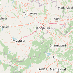
Map view of Mukurthi National Park

Use this park location map to pinpoint Mukurthi National Park in India, understand its exact geographic position, and read its mapped placement within the surrounding landscape more clearly.

Pigeon | © OpenStreetMap contributors

Location context for Mukurthi National Park

Nilgiri DistrictTamil Nadu
Park atlas

Explore the surrounding Nilgiri Hills region and compare adjacent protected landscapes, tracing the Western Ghats' biodiversity.

Discover Other National Parks and Protected Areas Near Mukurthi National Park

Browse a curated selection of national parks and protected areas geographically connected to Mukurthi National Park within the Nilgiri Biosphere Reserve and Western Ghats region. A comparative view helps you trace similar montane grasslands, shola forest patches, and high-elevation wildlife habitats to deepen your understanding of India's significant conservation landscapes.
Watercolor illustration of green hills, a river, and distant pink mountains
National parkKerala
About 15 km away#1 closest

South

Silent Valley National Park: Kerala's Protected Landscape and Geographic Atlas

Explore mapped boundaries and regional terrain in South India.

Silent Valley National Park stands as a key protected area within Kerala, India, offering rich insights into its geographic setting. This destination provides an atlas-driven view of the park's mapped boundaries, its integration with the surrounding regional geography, and the character of its natural landscapes. Users can engage with detailed information designed for structured exploration of protected natural areas and their mapped contexts.

Area
89.52 km²
Established
1984
IUCN
II
Relief
Mountain
Watercolor painting showing green fields, pink and yellow areas, and distant mountains
National parkNilgiri District
About 37 km away#2 closest

North

Mudumalai National Park: National Park Identity and Geographic Context in Nilgiri District

Mapped protected area and natural terrain details for this key Indian park.

Delve into the specific geographic identity of Mudumalai National Park, a protected national park situated in the Nilgiri District. This detail page provides access to its mapped natural landscape, helping users understand its protected boundaries and regional geographic significance. It serves as a foundational point for exploring the park's unique terrain within India's atlas of natural protected areas.

Area
321 km²
Established
1940
IUCN
II
Relief
Mountain
National parkKarnataka
About 40 km away#3 closest

North

Bandipur National Park: Karnataka's Protected Landscape and National Park Atlas Entry

Discover mapped terrain and diverse forest ecosystems in South India.

Bandipur National Park, a prominent national park within Karnataka, serves as a vital hub for understanding protected area geography and landscape diversity. Its ecological significance is amplified by its location at the intersection of the Deccan Plateau and the Western Ghats, supporting a unique blend of forest types and rich biodiversity. This entry provides essential context for atlas-based discovery, detailing the park's mapped terrain, its role as a tiger reserve, and its contribution to the Nilgiri Biosphere Reserve's conservation landscape.

Area
1,456.3 km²
Established
1973
IUCN
II
Relief
Mixed relief
National parkKarnataka
About 95 km away#4 closest

North

Nagarahole National Park: National Park within Karnataka's Protected Geography

Explore mapped boundaries and regional landscape context.

Nagarahole National Park stands as a distinct national park entity within the state of Karnataka, India. This section focuses on its specific geographic footprint and the protected landscape it encompasses, offering valuable data for users engaged in atlas-based discovery of India's conservation areas and natural terrains. Understand its mapped geography and regional significance.

Area
847.98 km²
Established
1983
IUCN
II
Relief
Upland
Wildlife reserveIndia
About 114 km away#5 closest

Southeast

Anaimalai Tiger Reserve: Wildlife Reserve Park Atlas and Geographic Context in India

Mapping protected landscapes and natural terrain of this Indian wildlife reserve.

Anaimalai Tiger Reserve is a significant wildlife reserve located in India, offering rich opportunities for geographic and atlas-based discovery. This page provides detailed information on its protected area status, mapped boundaries, and the surrounding natural landscape context. Delve into the park's specific geography to understand its role as a conservation area within the broader Indian subcontinent.

National parkKerala
About 125 km away#6 closest

Southeast

Eravikulam National Park: National Park with Mapped Protected Boundaries in Kerala

Understanding its geographic setting and landscape identity.

Delve into the protected landscape of Eravikulam National Park, a significant national park located in Kerala. This detailed entry focuses on its geographic coordinates, mapped boundaries, and its role as a distinct protected area within the regional geography. It serves as a valuable resource for exploring the park's natural terrain and its importance in conservation landscapes.

Area
97 km²
Established
1978
IUCN
II
Visitors
148.4K annual
National parkKerala
About 140 km away#7 closest

Southeast

Anamudi Shola National Park: Protected Montane Forest and Wildlife Corridor in Kerala

Explore unique high-altitude ecosystems and regional landscape context.

Anamudi Shola National Park is a compact yet ecologically significant protected area situated in the Western Ghats of Kerala, India. Covering around 7.5 square kilometers, the park preserves rare montane shola forests at elevations exceeding 2,100 meters. Its identity as a critical wildlife corridor, connecting contiguous protected zones, is fundamental to its conservation value. The park's landscape, defined by its unique ecosystems and regional geographic position, offers valuable insights for atlas-driven exploration of protected natural areas.

Area
7.5 km²
Established
2003
IUCN
II
Relief
Mountain
National parkIndia
About 151 km away#8 closest

Southeast

Pampadum Shola National Park: India's Protected Area Landscape Details

Explore mapped terrain and geographic context for this national park.

Gain insight into Pampadum Shola National Park, a key protected area within India's geography. This park detail provides essential information on its designation as a national park, its mapped boundaries, and its contribution to the regional landscape. It serves as a vital point for understanding the distribution and character of protected lands across India, offering a foundation for structured geographic research and atlas-based discovery of natural environments.

Common questions about visiting, size, designation, and location context for Mukurthi National Park

Mukurthi National Park FAQs for park facts, access, geography, and protected area context

Find quick answers about Mukurthi National Park, including protected-area facts, park geography, trail and visitor context, and how the park fits into its surrounding country and regional landscape.
MoriAtlas Explorer

Continue Your Protected Areas Search Across the Global Atlas

Deepen your exploration by continuing the structured search for national parks and protected areas worldwide. Utilize the comprehensive filtering capabilities to compare different conservation landscapes and refine your understanding of global park geography. Discover more about the distribution and characteristics of protected natural areas.

Global natural geography