

Mori Atlas logo
National parkMupa National Park

Explore the mapped boundaries and natural terrain of this national park in Cunene Province.

Mupa National Park: Protected Landscape and Geographic Atlas of Cunene Province, Angola

Mupa National Park stands as a significant protected landscape within the geographic expanse of Cunene Province, Angola. As a designated national park, it offers a unique point of focus for understanding regional protected areas and their mapped territories. This page serves as an atlas-focused entry to Mupa National Park, detailing its role in the conservation landscape and its place within the broader geographic context of southern Angola, allowing for structured discovery of its natural terrain and boundaries.

Angola national parkCunene provincesavanna protected areabird habitatSouthern Africa conservationsemi-arid ecosystem

Mupa National Park

National park

Park overview

Structured park overview, official facts, and landscape profile for Mupa National Park

Mupa National Park park facts, protected area profile, and essential visitor context
Review the core facts for Mupa National Park, including designation, size, terrain, visitor scale, habitats, and operating context in one park-focused overview.

About Mupa National Park

Mupa National Park occupies a vast expanse of southern Angola in the Cunene Province, a region characterized by flat savanna landscapes, seasonal rivers, and vegetation adapted to semi-arid conditions. Established in 1964, the park covers approximately 6,600 square kilometers, making it one of Angola's largest protected areas. The park's establishment reflected Angola's early commitment to wildlife conservation, though the country has since developed additional protected areas across its diverse ecological zones. Mupa sits within a broader landscape of communal grazing lands and agricultural zones, with human settlement occurring within the park boundaries. The park's location in southern Angola places it within a transition zone between more humid tropical regions to the north and the arid Kalahari ecosystems to the south, giving it a distinctive ecological character. Despite its size and potential significance, Mupa National Park remains relatively understudied, with limited research published on its biodiversity, ecosystem dynamics, or conservation status.

Quick facts and research context for Mupa National Park

Mupa National Park is located in the Cunene Province of southern Angola, spanning roughly 6,600 square kilometers of savanna and woodland habitat. The park was proclaimed a national park in December 1964 and represents one of Angola's oldest protected areas. Approximately 18,000 people reside within the park boundaries, primarily engaged in agriculture and cattle breeding activities. The park originally aimed to protect the Angolan giraffe subspecies, though populations have been extirpated since the 1970s. Notable mammal species include lion, leopard, African wild dog, and spotted hyena.

Park context

Deeper park guide and search-rich context for Mupa National Park

Mupa National Park history, landscape, wildlife, and travel context
Explore Mupa National Park through its history, landscape character, ecosystems, wildlife, conservation priorities, cultural context, and seasonal travel timing in a structured park guide built for atlas discovery and search intent.

Why Mupa National Park stands out

Mupa National Park is best known for its significant avian diversity, with the park holding particular importance for birdlife despite limited scientific study of its avifauna. The park's semi-arid savanna environment supports populations of large mammals including lion, leopard, wild dog, and spotted hyena. Historically, the park was established to protect the Angolan giraffe, a subspecies of giraffe endemic to the region, though this population has been lost. The park also represents an important conservation area in southern Angola, protecting representative examples of the region's woodland and savanna ecosystems.

Mupa National Park history and protected-area timeline

Mupa National Park was officially proclaimed on December 26, 1964, during Angola's colonial period under Portuguese administration. The park was initially established with the specific goal of protecting the Angolan giraffe subspecies, Giraffa camelopardalis angolensis, which is native to the region. At the time of establishment, Angola was known as Portuguese West Africa, and the creation of national parks reflected broader colonial conservation efforts in southern Africa. However, by 1974,仅仅十年后,公园内的长颈鹿种群已经消失,这可能是由于栖息地丧失、狩猎压力或与当地社区冲突的结果。安哥拉独立后,该公园继续作为保护区运作,但在随后的几十年里面临着人类住区扩大、游牧牧民活动增加和矿产勘探等多重压力。这些威胁,加上缺乏积极的管理和执法,导致公园的野生动物大幅减少。今天,虽然Mupa仍然是安哥拉保护遗产的重要组成部分,但其实施和有效管理仍然存在挑战。

Mupa National Park landscape and geographic character

Mupa National Park encompasses a landscape of flat to gently rolling savanna terrain typical of southern Angola. The region experiences a semi-arid climate with distinct wet and dry seasons, where seasonal rainfall supports grassland and woodland vegetation communities. The park's terrain includes valley areas where seasonal watercourses flow during the rainy season, providing important water sources for wildlife. The vegetation consists predominantly of miombo woodland in some areas mixed with open grasslands and bushland. The landscape provides relatively open terrain with scattered trees and shrubs, creating habitat favorable for large mammals and ground-dwelling bird species. The region's flat topography allows for extensive views across the savanna, particularly during the dry season when grass cover is reduced.

Mupa National Park ecosystems, habitats, and plant life

The park's ecological character is defined by its semi-arid savanna environment, which supports a mix of woodland and grassland habitats. The miombo woodland, characterized by Brachystegia and Julbernardia tree species, dominates portions of the park, interspersed with more open grass-dominated areas. This mosaic of habitats supports diverse ecological communities, from large mammals to numerous bird species. The park's significance for avifauna is particularly notable, with the diverse birdlife representing one of the park's most important ecological attributes, though comprehensive surveys remain limited. The seasonal availability of water influences wildlife distribution within the park, with permanent and seasonal water sources playing crucial roles in supporting animal populations throughout the year.

Mupa National Park wildlife and species highlights

Mupa National Park supports populations of several notable large mammal species. Lion and African leopard occur within the park, representing the region's apex predators. The park also hosts populations of African wild dog, also known as Cape wild dog, a species of conservation concern across much of its range, and spotted hyena. Historically, the park was established to protect Angolan giraffe, but this subspecies has been extirpated from the park since the 1970s. The park's birdlife is considered particularly significant, with diverse avifauna expected throughout the area though much remains unstudied. The combination of savanna and woodland habitats creates suitable conditions for numerous bird species, including both resident and migratory species that utilize the region seasonally.

Mupa National Park conservation status and protection priorities

Mupa National Park represents an important conservation area in southern Angola, protecting representative examples of the region's savanna and woodland ecosystems. The park's establishment reflected an early recognition of the need to protect Angola's natural heritage and distinctive wildlife, including the endemic Angolan giraffe subspecies. However, the park faces significant conservation challenges from human settlement and activities within its boundaries. Approximately 18,000 people live within the park, engaged primarily in agriculture and cattle breeding, which creates pressure on wildlife habitats. Additional threats include nomadic pastoralists whose livestock competes with native wildlife for resources, and mineral prospecting activities that can damage habitat and disturb wildlife. The loss of the giraffe population highlights the challenges facing conservation in the region, though efforts to protect remaining species and potentially restore extirpated populations remain important priorities.

Mupa National Park cultural meaning and human context

Mupa National Park contains significant human presence within its boundaries, with approximately 18,000 residents living within the park area. These communities are primarily engaged in agriculture and cattle breeding, activities that have shaped the landscape and continue to influence wildlife populations. The presence of pastoralists, both settled agricultural communities and nomadic herders, reflects the broader cultural pattern of southern Angola where livestock keeping remains important to local livelihoods. The interaction between human communities and wildlife creates both challenges for conservation and opportunities for community-based natural resource management. The park's management must balance conservation objectives with the needs and rights of resident communities, a common challenge across African protected areas.

Top sights and standout views in Mupa National Park

Mupa National Park stands as one of Angola's oldest and largest protected areas, established in 1964 to protect the distinctive wildlife of the Cunene Province. The park's vast savanna landscapes support populations of lion, leopard, wild dog, and hyena, while its birdlife remains an understudied but significant ecological asset. The park's history, including the loss of its giraffe population, illustrates both the challenges and the importance of conservation in the region. As a semi-arid protected area in southern Africa, Mupa represents a distinct ecosystem type within Angola's network of national parks and contributes to regional biodiversity conservation efforts.

Best time to visit Mupa National Park

The best time to visit Mupa National Park is during the dry season, typically from May to October, when wildlife viewing is more accessible as vegetation thins and animals concentrate around remaining water sources. The cooler months from June to August offer more comfortable conditions for outdoor activities. However, visitors should note that the park's infrastructure and visitor facilities are limited, and access may be challenging. The wet season from November to April brings green landscapes but can make some areas difficult to access and wildlife more dispersed. Given the park's limited development as a tourism destination, visitors should prepare for a more adventurous and self-sufficient travel experience.

Park location guide

Geography guide, regional context, and park location map for Mupa National Park

Mupa National Park park geography, regions, and map view in Angola
Understand where Mupa National Park sits in Angola through a broader geographic reading of the surrounding landscape, nearby location context, and its mapped position within the national park landscape.

How Mupa National Park fits into Angola

Angola is a unitary presidential republic on the western coast of Southern Africa. Gaining independence from Portugal in 1975, it borders Namibia, the Democratic Republic of the Congo, Zambia, and the Atlantic Ocean. The country has an exclave province called Cabinda. With a population of over 36 million, Angola is rich in oil and mineral resources.

Wider geography shaping Mupa National Park in Angola

Angola is located on the western coast of Southern Africa along the Atlantic Ocean. It is bordered by Namibia to the south, the Democratic Republic of the Congo to the north, Zambia to the east, and the Atlantic Ocean to the west. The country includes the exclave province of Cabinda, which borders the Republic of the Congo and the Democratic Republic of the Congo. The terrain includes coastal lowlands, highland plateaus, and interior plains.

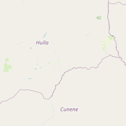
Map view of Mupa National Park

Use this park location map to pinpoint Mupa National Park in Angola, understand its exact geographic position, and read its mapped placement within the surrounding landscape more clearly.

Pigeon | © OpenStreetMap contributors

Location context for Mupa National Park

Cunene Province
Park atlas

Explore Angola's savanna protected landscapes and compare mapped geography in the Cunene Province and surrounding regions.

Discover Nearby National Parks and Protected Areas Beyond Mupa National Park in Angola
Continue your exploration from Mupa National Park to browse other national parks and protected areas across Angola's diverse landscapes. Compare the unique semi-arid savanna ecosystems and regional conservation efforts of adjacent protected areas, gaining broader geographic context for Southern Africa's natural heritage.
National parkKunene Region

Etosha National Park National Park: Mapped Protected Landscape and Regional Geography

Discover its protected boundaries and geographic context.

Gain a structured understanding of Etosha National Park, a prominent national park within Namibia's Kunene Region. This entry focuses on the park's protected landscape identity, detailing its mapped boundaries and geographic significance. Explore Etosha National Park through the lens of atlas-driven discovery, appreciating its role as a key protected area and its contribution to the regional geography of the surrounding landscape.

Area
22,270 km²
Established
1907
IUCN
II
Visitors
200K annual
National parkNamibe Province

Iona National Park: Mapped Protected Landscape in Namibe Province, Angola

Explore the geographic extent and regional context of this national park.

Iona National Park stands as a protected natural area within the administrative region of Namibe Province, Angola. This atlas-focused entry provides detailed insights into the park's mapped boundaries, its regional geographic positioning, and its role as a conservation landscape. Users can engage with specific data to understand the terrain and protected land distribution within this significant Angolan national park.

Area
15,200 km²
Established
1964
IUCN
II
Relief
Mixed relief
National parkNamibia

Skeleton Coast National Park: Namibia's Remote Desert-Coast National Park Exploration

Mapped landscape, shipwrecks, and profound geographic isolation.

Delve into the Skeleton Coast National Park, a monumental protected area in Namibia defined by its stark desert and ocean interface. This page provides detailed geographic context for the park's vast expanse, highlighting its characteristic shipwrecks and the dramatic landscape where towering sand dunes confront the cold Atlantic. Understand the unique protected-area identity of this legendary coastal wilderness through its mapped features and remote setting.

Area
16,845 km²
Established
1971
IUCN
II
Relief
Lowland
National parkNamibia

Mangetti National Park: Protected Landscape and Geographic Atlas in Namibia

Explore mapped boundaries within Namibia's arid terrain.

Mangetti National Park serves as a crucial protected area, offering insights into Namibia's unique geography and conservation landscapes. Delve into the mapped extent of this national park, understanding its specific location and its contribution to the atlas of protected lands in southern Africa. Examine its geographic character and the context it provides for appreciating the country's natural heritage.

Area
420 km²
Established
2008
IUCN
II
Relief
Lowland
National parkAngola

Mavinga National Park: Protected Landscape Identity and Geographic Mapping in Angola

Explore mapped boundaries and regional context of this national park.

Mavinga National Park stands as a designated protected area within Angola, offering insights into the nation's natural landscapes and conservation efforts. This entry details the park's geographic footprint and its role as a national park. It provides users with essential map-based discovery tools to understand the park's setting, its physical geography, and its significance as a protected natural landscape in southern Africa.

Area
46,076 km²
Established
2011
IUCN
II
Relief
Lowland
National parkNamibia

Khaudum National Park: Namibia's Remote Kalahari Protected Landscape and Predatory Wildlife

Explore mapped boundaries and seasonal river ecosystems.

Khaudum National Park is a substantial protected landscape in northeastern Namibia, deep within the Kalahari Desert. This remote national park encompasses over 3,800 square kilometers of dry forest and acacia woodland, dissected by three major Omuramba dry river systems. It is globally recognized for its thriving populations of large predators like lions and spotted hyenas, alongside significant numbers of elephants and giraffes. The park's unique semi-arid terrain and biodiversity make it a key destination for understanding regional protected-area geography and landscape context.

Area
3,842 km²
IUCN
II
Relief
Lowland
Climate
Arid
National parkAngola

Luengue-Luiana National Park: Angola's Premier Protected Woodland and Floodplain Ecosystem

Mapping crucial habitats for large mammals and avian wildlife.

Luengue-Luiana National Park is a vital protected landscape in southeastern Angola, covering an immense area that transitions from open woodland ecosystems to vast, seasonal floodplain grasslands. As a cornerstone of the Kavango-Zambezi Transfrontier Conservation Area, it facilitates critical wildlife movements and supports significant populations of large mammals. Its geography provides essential habitat, particularly within the extensive wetland wilderness and riparian zones along the Cuando River, making it a significant site for regional biodiversity and atlas exploration.

Area
42,000 km²
Established
2011
IUCN
II
Relief
Lowland
National parkMalanje Province

Cangandala National Park: Angola's Protected Landscape in Malanje Province

Discover National Park Geography and Boundaries

Investigate Cangandala National Park, a significant protected area situated in Malanje Province, Angola. This page provides detailed geographic context, focusing on the park's mapped boundaries and its role as a national park within the region's atlas. Explore the fundamental protected landscape characteristics and its specific contribution to Angola's conservation geography, offering a clear entry point for understanding this unique natural area.

Area
600 km²
Established
1970
Relief
Upland
Climate
Tropical

Common questions about visiting, size, designation, and location context for Mupa National Park

Mupa National Park FAQs for park facts, access, geography, and protected area context
Find quick answers about Mupa National Park, including protected-area facts, park geography, trail and visitor context, and how the park fits into its surrounding country and regional landscape.
MoriAtlas Explorer

Continue Your Protected Areas Search Across the Global Atlas

Deepen your exploration by continuing the structured search for national parks and protected areas worldwide. Utilize the comprehensive filtering capabilities to compare different conservation landscapes and refine your understanding of global park geography. Discover more about the distribution and characteristics of protected natural areas.

Global natural geography