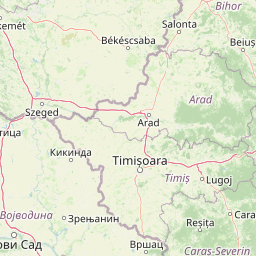
Discover the mapped boundaries and regional geography of this significant protected area.
Mureş Floodplain Natural Park stands as a key protected area within Romania, offering a detailed study of its mapped boundaries and unique geographic setting. This page serves as an atlas-driven entry point to understanding the park's landscape context, its position within Romania's diverse geography, and the broader protected land network. Explore the features that define this important natural reserve through a structured, map-centric lens.
Mureş Floodplain Natural Park
Protected area
Structured park overview, official facts, and landscape profile for Mureş Floodplain Natural Park
Geography guide, regional context, and park location map for Mureş Floodplain Natural Park
Romania is a unitary semi-presidential republic located in Southeast and Central Europe. It borders Ukraine, Hungary, Serbia, Bulgaria, Moldova, and the Black Sea. The country has a population of approximately 19 million and covers an area of 238,397 km². Bucharest is the capital and largest city. Romania joined the European Union in 2007.
Romania lies on the lower course of the Danube River, north of the Balkan Peninsula, and on the northwestern shore of the Black Sea. The terrain is varied, featuring the Carpathian Mountains in the center, the Transylvanian Plateau, the Moldavian Plateau, and plains along the Danube and in the south. The country has a diverse landscape that includes forests, meadows, and wetland areas.
Common questions about visiting, size, designation, and location context for Mureş Floodplain Natural Park
Deepen your exploration by continuing the structured search for national parks and protected areas worldwide. Utilize the comprehensive filtering capabilities to compare different conservation landscapes and refine your understanding of global park geography. Discover more about the distribution and characteristics of protected natural areas.