

Mori Atlas logo
National parkMweru Wantipa National Park

Explore the mapped boundaries and regional atlas context of this national park.

Mweru Wantipa National Park: Protected Landscape Geography in Zambia's Northern Province

Mweru Wantipa National Park stands as a key protected area within Zambia's Northern Province, offering critical geographic context for atlas exploration. This national park represents a significant mapped landscape, inviting discovery of its protected boundaries and natural terrain. Understand its place within regional geography through a structured, map-driven approach to protected land identification.

Miombo woodlandsItigi-Sumbu thicketRare vegetationLake habitatZambiaNorthern Province

Mweru Wantipa National Park

National park

Park overview

Structured park overview, official facts, and landscape profile for Mweru Wantipa National Park

Mweru Wantipa National Park park facts, protected area profile, and essential visitor context

Review the core facts for Mweru Wantipa National Park, including designation, size, terrain, visitor scale, habitats, and operating context in one park-focused overview.

About Mweru Wantipa National Park

Mweru Wantipa National Park is located in the Northern Province of Zambia, a region characterized by rolling woodlands, wetlands, and the prominent Lake Mweru Wantipa after which the park is named. The park's setting within the Central Zambezian Miombo woodlands places it within one of Africa's most extensive woodland ecoregions, where the miombo ecosystem dominates large tracts of southern-central Africa. However, what makes Mweru Wantipa truly exceptional is its inclusion of Itigi-Sumbu thicket, a dense, almost impenetrable vegetation community that represents one of the rarest habitat types on the African continent. This thicket, characterized by a dense tangle of approximately a hundred plant species forming a virtually impassable wall of vegetation, is known from only one other location in central Tanzania. The thicket's presence here makes the park globally significant for biodiversity conservation, as this unique ecosystem exists in virtually no other protected area. The park's proximity to Lake Mweru Wantipa adds ecological value, as the lake and its associated wetlands provide additional habitat diversity within the protected landscape. Despite its ecological significance, Mweru Wantipa has received minimal investment in infrastructure, management, or protection, leaving its remarkable natural assets vulnerable to degradation and loss.

Quick facts and research context for Mweru Wantipa National Park

Mweru Wantipa National Park covers the region around Lake Mweru Wantipa in Zambia's Northern Province. The park falls within the Central Zambezian Miombo woodlands ecoregion but contains the rare Itigi-Sumbu thicket vegetation type, found nowhere else in Zambia and only one other place in Tanzania. The park was once home to significant populations of large mammals including elephant, lion, and black rhinoceros, but wildlife populations have been drastically reduced due to prolonged lack of management and protection. The park currently lacks visitor facilities and remains one of Zambia's least developed protected areas.

Protection and recognition

Analyzing the terrestrial scope, official records, and conservation framework of the park

Mweru Wantipa National Park Protection Status and Designation Details

Mweru Wantipa National Park protection status details cover the officially documented boundaries and terrestrial conservation scope of the landscape. Verifying registered protected area designation records provides clear geographic context for analyzing regional conservation frameworks and management history.

Protection details

Protection scope
Terrestrial
Transboundary protection
No
Park context

Deeper park guide and search-rich context for Mweru Wantipa National Park

Mweru Wantipa National Park history, landscape, wildlife, and travel context

Explore Mweru Wantipa National Park through its history, landscape character, ecosystems, wildlife, conservation priorities, cultural context, and seasonal travel timing in a structured park guide built for atlas discovery and search intent.

Why Mweru Wantipa National Park stands out

Mweru Wantipa National Park is best known for two contrasting stories: the presence of Itigi-Sumbu thicket, one of Africa's rarest and most botanically significant vegetation types found almost nowhere else on the continent, and its dramatic wildlife decline from a once-abundant landscape to one where black rhinoceros have gone extinct and elephant and lion have likely been eliminated. The park represents a stark example of what happens when protected areas receive no effective management, making it significant both as a conservation priority and as a case study in protected area stewardship failures.

Mweru Wantipa National Park history and protected-area timeline

Mweru Wantipa National Park was established as a protected area designated under IUCN Category II, reflecting its national park status and the intention to preserve its natural values. The park was created to protect the unique landscape surrounding Lake Mweru Wantipa and the distinctive ecosystems found within the region. For several decades following its establishment, the park has experienced a profound absence of effective management and protection infrastructure. This management vacuum has allowed significant degradation of both the park's wildlife populations and its unique vegetation communities. The destruction of approximately 70% of the Itigi-Sumbu thicket within the park, including areas along the north shore of the lake where the largest patches were located, demonstrates the consequences of inadequate protection. This historical trajectory from a once-wild landscape to a depleted ecosystem represents one of the more cautionary stories within Zambia's national park system.

Mweru Wantipa National Park landscape and geographic character

The landscape of Mweru Wantipa National Park is defined by the interplay between miombo woodland savanna and the unique Itigi-Sumbu thicket, creating a mosaic of contrasting vegetation types across the protected area. The dominant miombo woodlands consist of deciduous trees from the Brachystegia genus, creating a seasonally variable canopy that sheds leaves during the dry winter months. Interspersed within this woodland matrix are patches of Itigi-Sumbu thicket, an extraordinarily dense vegetation formation that stands in sharp contrast to the more open miombo woodland. Lake Mweru Wantipa itself forms a prominent geographic feature, a large shallow lake whose margins support wetland vegetation and provide water resources for the surrounding landscapes. The terrain across the park is generally flat to gently rolling, typical of the central African plateau, with the thicket patches typically occurring in depressions or areas with particular soil conditions that favor this dense vegetation type.

Mweru Wantipa National Park ecosystems, habitats, and plant life

The ecological character of Mweru Wantipa is defined by the overlap of two major vegetation systems: the widespread Central Zambezian Miombo woodlands and the extremely rare Itigi-Sumbu thicket. This thicket represents one of Africa's most restricted vegetation types, with the Mweru-Wantipa area and one location in central Tanzania being the only known occurrences globally. The thicket's botanical composition includes approximately a hundred plant species that grow together in such dense interconnection that the formation becomes virtually impassable for humans. This unique habitat supports specialized species that depend on the thicket's structure and provides ecosystem functions distinct from the surrounding miombo. The destruction of 70% of this thicket within the park represents a significant biodiversity loss at a continental scale. The park also incorporates the aquatic and wetland ecosystems associated with Lake Mweru Wantipa, adding further ecological diversity to the protected area's character.

Mweru Wantipa National Park wildlife and species highlights

Mweru Wantipa National Park was historically home to significant populations of Africa's iconic large mammals, including elephant, lion, and black rhinoceros. These species represented the park's primary wildlife value and attracted attention as conservation targets for the protected area. However, the prolonged period without effective management and protection has led to catastrophic wildlife decline. Black rhinoceros have been declared extinct from the area, representing a complete loss of a species that was once present within the park. Elephant and lion populations have likely been eliminated as well, though direct confirmation may be limited. This wildlife collapse represents one of the most severe examples of protected area failure in Zambia's conservation estate. The remaining wildlife in the park consists primarily of smaller species that have managed to persist despite the absence of management, though the overall biodiversity value has been severely compromised from its historical baseline.

Mweru Wantipa National Park conservation status and protection priorities

Mweru Wantipa National Park represents a critical conservation challenge due to the dual pressures of habitat destruction and wildlife collapse. The park's global significance stems primarily from containing one of only two known locations for Itigi-Sumbu thicket on Earth, making its preservation essential for maintaining this rare ecosystem type. The fact that approximately 70% of this thicket has already been destroyed, including areas within the nominally protected national park boundaries, demonstrates the severity of the conservation crisis facing this area. Conservation experts estimate that the remaining Itigi-Sumbu thicket could be lost within the next two decades if protective measures are not implemented. The park's designation as an IUCN Category II protected area provides formal recognition of its conservation importance, but without effective on-ground management, this designation has proven insufficient to prevent degradation. The extinction of black rhinoceros and likely elimination of elephant and lion from the park illustrates how quickly wildlife populations can collapse without active protection.

Mweru Wantipa National Park cultural meaning and human context

Mweru Wantipa National Park takes its name from Lake Mweru Wantipa, which has historically been an important resource for local communities in Zambia's Northern Province. The lake and surrounding landscapes have supported fishing, pastoral activities, and other traditional land uses by local populations for generations. The park's establishment as a protected area occurred within the broader context of Zambia's post-independence conservation planning, which sought to designate significant natural areas for protection while balancing community interests. However, the absence of effective management infrastructure has meant that the park has not developed the visitor engagement or community partnership programs that characterize better-managed protected areas in Zambia.

Top sights and standout views in Mweru Wantipa National Park

The most remarkable feature of Mweru Wantipa National Park is its role as a refuge for Itigi-Sumbu thicket, one of Africa's most restricted and botanically significant vegetation types, found almost nowhere else on the continent. The park's location around Lake Mweru Wantipa adds scenic and ecological value, with the lake providing wetland habitats and water resources within the protected landscape. Despite its ecological significance, the park's story is ultimately one of conservation failure, with 70% of its rare thicket destroyed and its large mammal populations eliminated. This combination of extreme biodiversity value and severe degradation makes the park a compelling case for conservation intervention.

Best time to visit Mweru Wantipa National Park

Given the park's current lack of visitor facilities and management infrastructure, visits to Mweru Wantipa require careful planning and self-sufficiency. The dry season from May to October offers more accessible terrain and clearer visibility for wildlife viewing, though wildlife populations are severely depleted from historical levels. The landscape retains its ecological interest year-round due to the unique vegetation communities present, particularly the Itigi-Sumbu thicket. Visitors should be prepared for a remote experience with minimal infrastructure and should not expect the developed tourism facilities found in Zambia's better-known national parks.

Monthly climate preview

Long term average temperature and monthly precipitation patterns sampled at representative elevation

Mweru Wantipa National Park Climate Normals and Annual Weather Rhythm

Recorded measurements show a distinct annual cycle of temperatures and monthly precipitation values across the representative coordinate. Exploring the complete twelve month profile provides detailed climate data for analysis.
Annual mean23 °C
20 °C26 °C
Jan22°
Feb22°
Mar23°
Apr22°
May22°
Jun20°
Jul20°
Aug22°
Sep25°
Oct26°
Nov24°
Dec22°
Warmest month
October

25.9 °C

Coolest month
July

19.9 °C

Wettest month
December

6.5 mm/day

Driest month
July

0 mm/day

Park location guide

Geography guide, regional context, and park location map for Mweru Wantipa National Park

Mweru Wantipa National Park park geography, regions, and map view in Zambia

Understand where Mweru Wantipa National Park sits in Zambia through a broader geographic reading of the surrounding landscape, nearby location context, and its mapped position within the national park landscape.

How Mweru Wantipa National Park fits into Zambia

Zambia is a landlocked nation in Southern Africa with a population of approximately 20 million people. The country is bordered by eight countries and features diverse geography ranging from the Zambezi River to vast plateaus. Lusaka serves as the capital and largest city, while the Copperbelt Province in the north drives much of the economy through copper mining.

Wider geography shaping Mweru Wantipa National Park in Zambia

Zambia is located in Southern Africa and is landlocked, bordered by eight countries: Democratic Republic of the Congo to the north, Tanzania to the northeast, Malawi to the east, Mozambique to the southeast, Zimbabwe and Botswana to the south, Namibia to the southwest, and Angola to the west. The country features varied terrain including the Zambezi River plain in the south, plateaus in the central and northern regions, and the Muchinga Mountains in the northeast. Lake Tanganyika forms part of the northern border.

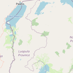
Map view of Mweru Wantipa National Park

Use this park location map to pinpoint Mweru Wantipa National Park in Zambia, understand its exact geographic position, and read its mapped placement within the surrounding landscape more clearly.

Pigeon | © OpenStreetMap contributors

Location context for Mweru Wantipa National Park

Northern Province
Recorded earthquake history

Explore Historical Earthquake Records for Mweru Wantipa National Park

Access the comprehensive collection of seismic events recorded near Mweru Wantipa National Park. MoriAtlas provides a clear, data-driven view of regional seismic history, allowing for an informed perspective on historical activity patterns surrounding this unique Northern Province protected landscape.

Mweru Wantipa National Park Earthquake History

Catalogued events

25 events

Strongest magnitude

Magnitude 5.9

Most recent event

Feb 29, 2024

This history includes earthquakes recorded inside the park or within 50 km of its borders

Park atlas

Explore adjacent conservation landscapes, compare regional park geography, and trace the spread of protected areas surrounding Mweru Wantipa National Park.

Discover More Protected Areas Near Mweru Wantipa National Park and Zambia's Northern Province

Explore national parks and protected areas located near Mweru Wantipa National Park, tracing their geographic distribution and unique ecological characteristics within Zambia's Northern Province. Continue your atlas discovery by comparing surrounding protected landscapes, understanding regional conservation efforts, and mapping the diverse miombo woodlands and rare thicket habitats.
National parkZambia
29 km away#1 closest

East

Nsumbu National Park: Zambia's Lakeside Protected Landscape, Map Atlas, and Geographic Context

Mapped terrain and unique shoreline geography.

Nsumbu National Park stands as a vital protected landscape in Zambia, defined by its prominent position on Lake Tanganyika. The park's approximately 2,026 square kilometers showcase a dramatic geographic interplay between terrestrial environments, including miombo woodlands and rare Itigi-Sumbu thicket, and the vast aquatic expanse of the lake. Users exploring this atlas entry will find detailed information on the park's mapped boundaries, distinctive shoreline features like rocky cliffs and sandy beaches, and its overall role in the regional geography of Southern Africa.

Area
2,026 km²
Established
1985
IUCN
II
Relief
Lowland
National parkLuapula Province
About 66 km away#2 closest

Southwest

Lusenga Plain National Park: Zambia National Park Geographic Atlas

Mapped park boundaries and regional landscape context.

Gain a structured understanding of Lusenga Plain National Park, a dedicated national park situated in Zambia's Luapula Province. This resource details the park's geographic dimensions and its placement within the regional landscape, providing essential context for atlas exploration and a mapped view of protected lands.

Area
800 km²
Established
1972
IUCN
II
Relief
Lowland
National parkHaut-Katanga Province
206 km away#3 closest

Southwest

Kundelungu National Park National Park: Central Africa's Protected Savanna Landscape

Explore the mapped terrain and dramatic geography of this Haut-Katanga Province protected area.

Kundelungu National Park stands as a significant protected area within the Haut-Katanga Province, offering a deep dive into Central Africa's expansive savanna ecosystems and unique natural landmarks. This national park is defined by its rolling grasslands, dotted with characteristic forest galleries that trace the region's water systems, alongside the awe-inspiring Lofoi Falls. Understanding Kundelungu National Park through its mapped boundaries and geographic context reveals its importance as a protected landscape and a key component of regional conservation efforts within the DRC.

Area
7,600 km²
Established
1970
IUCN
II
Relief
Upland
National parkDemocratic Republic of the Congo
209 km away#4 closest

West

Upemba National Park: Protected Landscape and Geographic Atlas within the Democratic Republic of the Congo

Explore its mapped boundaries and diverse ecosystems.

Upemba National Park, located in the Democratic Republic of the Congo, is a premier destination for understanding protected landscapes and regional geography. This national park is characterized by its extensive wetlands, lake ecosystems, and mountainous terrain, providing a rich environment for atlas-driven discovery. Its unique geographic context and diverse habitats make it a pivotal site for exploring central African protected areas and their ecological significance.

Area
11,730 km²
Established
1939
IUCN
II
Relief
Mixed relief
National parkUvinza District
221 km away#5 closest

North

Mahale Mountains National Park: Tanzania's Remote Mountain Forest & Lake Tanganyika Landscape

Explore unique primate habitats and dramatic protected terrain.

Mahale Mountains National Park stands as a testament to unique ecological convergence, where the Mahale Mountains' dense forests dramatically meet the vast expanse of Lake Tanganyika. This protected area is globally recognized for harboring the largest wild population of eastern chimpanzees, offering a rare glimpse into their behavior within a pristine wilderness. The park's landscape is defined by steep mountain slopes, diverse woodland, and aquatic environments, creating a distinctive geographic context that sets it apart from typical savanna protected areas in Tanzania.

Area
1,650 km²
Established
1985
IUCN
II
Visitors
1.1K annual
National parkKatavi Region
About 231 km away#6 closest

Northeast

Katavi National Park: A Vast Protected Landscape in Tanzania's Katavi Region

Explore its unique floodplains, seasonal wetlands, and wildlife spectacles.

Katavi National Park is a significant national park located in the Katavi Region of Tanzania, spanning over 4,471 square kilometers. This remote protected area is characterized by extensive floodplains, the vital Katuma River system, and seasonal lakes like Lake Katavi and Lake Chada, which undergo dramatic changes throughout the year. The park's geography supports a dynamic ecosystem renowned for its large wildlife populations, including spectacular hippo gatherings during dry periods and vast herds of buffaloes and elephants roaming its uncrowded savannas. Katavi offers an unparalleled glimpse into a wild, untamed African landscape.

Area
4,471 km²
Established
1974
IUCN
II
Visitors
1.5K annual
National parkNorthern Province
About 264 km away#7 closest

Southeast

Isangano National Park: Exploring Its Protected Landscape and Geographic Identity in Northern Province

Discover the mapped boundaries and regional context of this national park.

Isangano National Park stands as a protected national park within the vast geographic expanse of Zambia's Northern Province. This dedicated entry provides critical context for understanding the park's role as a conservation landscape, detailing its physical geography and its position within regional atlas data. Explore the mapped outlines and natural terrain features that define Isangano National Park, offering a foundational view for broader geographic exploration and protected-area research.

Area
840 km²
Established
1972
Relief
Lowland
Climate
Tropical
National parkTabora Region
About 365 km away#8 closest

Northeast

Ugalla River National Park: A Tanzania National Park for Geographic Discovery

Explore protected area boundaries and regional landscape context.

Ugalla River National Park serves as a key protected area within Tanzania, specifically situated in the Tabora Region. This page provides essential geographic context, detailing its mapped boundaries and its significance as a national park. It’s designed for users seeking structured information about protected landscapes and their placement within regional geography, offering a factual basis for atlas exploration.

Area
3,865 km²
Established
2019
IUCN
II
Relief
Upland

Common questions about visiting, size, designation, and location context for Mweru Wantipa National Park

Mweru Wantipa National Park FAQs for park facts, access, geography, and protected area context

Find quick answers about Mweru Wantipa National Park, including protected-area facts, park geography, trail and visitor context, and how the park fits into its surrounding country and regional landscape.
MoriAtlas Explorer

Continue Your Protected Areas Search Across the Global Atlas

Deepen your exploration by continuing the structured search for national parks and protected areas worldwide. Utilize the comprehensive filtering capabilities to compare different conservation landscapes and refine your understanding of global park geography. Discover more about the distribution and characteristics of protected natural areas.

Global natural geography
