Mori Atlas logo
National parkMyōkō-Togakushi Renzan National Park

Trace the mapped terrain and regional landscape context of this protected Japanese national park.

Myōkō-Togakushi Renzan National Park: Japan's National Park Geography and Protected Boundaries

Myōkō-Togakushi Renzan National Park represents a significant protected area within Japan's diverse geography. As a designated national park, its mapped boundaries delineate a unique landscape offering insights into the natural terrain and regional ecological context. This page serves as an atlas-focused entry point for understanding the park's geographic identity and its place within Japan's protected lands network, emphasizing mapped exploration and discovery.

volcanic mountainsalpine environmentsJapanese Alpsmountain hikingcrater lakesactive volcano

Myōkō-Togakushi Renzan National Park

National park

Park overview

Structured park overview, official facts, and landscape profile for Myōkō-Togakushi Renzan National Park

Myōkō-Togakushi Renzan National Park park facts, protected area profile, and essential visitor context
Review the core facts for Myōkō-Togakushi Renzan National Park, including designation, size, terrain, visitor scale, habitats, and operating context in one park-focused overview.

About Myōkō-Togakushi Renzan National Park

Myōkō-Togakushi Renzan National Park occupies a distinctive position in central Japan's mountainous interior, protecting a compact but ecologically significant cluster of peaks that form part of the larger Japanese Alps system. The park's creation in 2015 reflected a recognition that this particular mountain ensemble warranted separate national park designation to ensure focused conservation attention and management. The landscape is defined by volcanic mountains that rise dramatically from the surrounding hills, creating a landscape of sharp ridgelines, steep slopes, and alpine meadows. The geological history of these peaks has produced varied terrain, from volcanic crater areas to steep-sided valleys carved by ancient glaciers and erosion. Beyond the natural landscape, the mountains have historically served as sites of religious significance, with shrines and pilgrimage routes threading through the area, particularly around Mount Togakushi where traditional mountain worship practices have persisted.

Quick facts and research context for Myōkō-Togakushi Renzan National Park

Myōkō-Togakushi Renzan National Park is located in the Chūbu region of central Honshu, Japan, straddling Niigata and Nagano Prefectures. The park was established on March 27, 2015, when it was separated from the former Jōshin'etsu-kōgen National Park. The protected area covers 39,772 hectares and is managed by Japan's Ministry of the Environment. The park encompasses seven major peaks exceeding 1,900 meters in elevation, with Mount Hiuchi being the highest at 2,462 meters. The park includes notable water bodies such as Lake Nojiri and Lake Reisenji, which add to the scenic diversity of the alpine landscape.

Park context

Deeper park guide and search-rich context for Myōkō-Togakushi Renzan National Park

Myōkō-Togakushi Renzan National Park history, landscape, wildlife, and travel context
Explore Myōkō-Togakushi Renzan National Park through its history, landscape character, ecosystems, wildlife, conservation priorities, cultural context, and seasonal travel timing in a structured park guide built for atlas discovery and search intent.

Why Myōkō-Togakushi Renzan National Park stands out

Myōkō-Togakushi Renzan National Park is best known for its spectacular mountain landscape characterized by a cluster of steep volcanic peaks rising sharply from the surrounding lowlands. The park protects a series of prominent mountains including Mount Hiuchi, Mount Myōkō, Mount Takatsuma, Mount Iizuna, and Mount Togakushi, each offering distinctive geological features and alpine environments. The presence of Mount Yakeyama as an active volcano adds geological significance, while the network of mountain trails and traditional pilgrimage routes connecting the various peaks provides cultural and recreational value. Lake Nojiri at the foot of the mountains offers additional scenic appeal and ecological habitat within the park boundary.

Myōkō-Togakushi Renzan National Park history and protected-area timeline

The national park was officially established on March 27, 2015, when the Japanese government redesignated a portion of the former Jōshin'etsu-kōgen National Park as a separate protected area. This administrative change reflected the growing recognition that the Myōkō-Togakushi mountain cluster possessed distinct ecological and scenic characteristics that warranted dedicated national park status. Prior to 2015, the area had been protected as part of Jōshin'etsu-kōgen, one of Japan's older national parks established in 1934, but the separation allowed for more focused management attention on this particular mountain region. The establishment of the park represented a continuation of Japan's postwar conservation evolution, which has progressively added new national parks and expanded protected area networks to preserve the nation's most significant natural landscapes.

Myōkō-Togakushi Renzan National Park landscape and geographic character

The park's landscape is dominated by a dramatic cluster of volcanic mountains that form a compact but visually striking mountain group. The highest peak, Mount Hiuchi, reaches 2,462 meters and is flanked by Mount Myōkō at 2,454 meters, with both peaks featuring steep pyramidal forms typical of young volcanic mountains. Mount Yakeyama at 2,400 meters remains volcanically active, representing the geological dynamism that shaped and continues to influence the landscape. The mountain group includes Mount Takatsuma (2,353m), Mount Kurohome (2,054m), Mount Iizuna (1,917m), and Mount Togakushi (1,904m), creating a skyline of multiple prominent peaks. Between the mountains lie valleys and basins that contain significant water bodies, including Lake Nojiri, a scenic caldera lake that reflects the mountains in its waters, and the smaller Lake Reisenji. The combination of high peaks, volcanic terrain, alpine meadows, and lake basins creates a landscape of considerable scenic diversity within a relatively compact area.

Myōkō-Togakushi Renzan National Park ecosystems, habitats, and plant life

The ecological character of Myōkō-Togakushi Renzan reflects its position in the subalpine zone of central Japan, where montane and subalpine forest ecosystems transition with altitude. The lower slopes of the protected mountains support dense forest cover, while the higher elevations feature alpine vegetation communities adapted to the harsh mountain environment. The varied aspect of different peaks and their slopes creates diverse microclimates and habitat conditions across the park. The volcanic nature of several peaks influences soil chemistry and vegetation patterns, with areas of recent volcanic activity supporting earlysuccessional plant communities. The presence of significant water bodies including Lake Nojiri adds wetland habitat diversity to the primarily mountain-focused ecosystem.

Myōkō-Togakushi Renzan National Park conservation status and protection priorities

The national park designation provides formal protection for a representative sample of Japan's alpine mountain ecosystems and volcanic landscapes. The park conserves both the geological features associated with volcanic activity and the ecological communities that depend on the diverse mountain habitats. As a Category II protected area under the IUCN classification, the park is managed with the dual goals of ecosystem preservation and public enjoyment, balancing conservation needs with sustainable recreation opportunities. The separation from the larger Jōshin'etsu-kōgen National Park in 2015 allowed for more tailored management approaches specific to the ecological and scenic values of this particular mountain cluster.

Myōkō-Togakushi Renzan National Park cultural meaning and human context

The mountains within the park have historical significance as sites of traditional Japanese mountain worship and religious practice. Mount Togakushi in particular has been a destination for pilgrims and worshippers, with shrines located at various elevations on the mountain reflecting longstanding spiritual connections to the landscape. The network of trails that connects the various peaks has been used for centuries both for religious pilgrimage and practical travel between communities in the surrounding prefectures. This cultural layer adds historical depth to the natural landscape, though the primary focus of the national park designation centers on natural ecosystem preservation.

Top sights and standout views in Myōkō-Togakushi Renzan National Park

The park's main highlights include the spectacular cluster of volcanic peaks that form its geographic core, with Mount Hiuchi and Mount Myōkō offering dramatic mountain scenery and challenging climbing opportunities. Lake Nojiri provides a accessible scenic feature at the mountain base, while the diversity of peaks ranging from active volcanoes to traditional pilgrimage destinations offers varied visitor experiences. The alpine environment supports distinctive mountain ecosystems, and the compact nature of the park allows visitors to experience multiple peaks and environments within a relatively limited area.

Best time to visit Myōkō-Togakushi Renzan National Park

The most favorable conditions for visiting Myōkō-Togakushi Renzan National Park occur during the summer months from June through September, when trail conditions are most stable and the alpine environment is accessible without winter equipment. Autumn provides another attractive season, with autumn foliage coloring the mountain slopes and clear skies typically prevailing. Winter transforms the landscape into a snow-covered mountain environment suitable for winter sports but requiring appropriate equipment and preparation for the harsh conditions. The shoulder seasons of spring and late autumn offer quieter conditions but involve more variable weather and potential trail closures.
Park location guide

Geography guide, regional context, and park location map for Myōkō-Togakushi Renzan National Park

Myōkō-Togakushi Renzan National Park park geography, regions, and map view in Japan
Understand where Myōkō-Togakushi Renzan National Park sits in Japan through a broader geographic reading of the surrounding landscape, nearby location context, and its mapped position within the national park landscape.

How Myōkō-Togakushi Renzan National Park fits into Japan

Japan is an island nation in East Asia comprising over 14,000 islands in the Pacific Ocean. The country operates as a unitary parliamentary constitutional monarchy with Emperor Naruhito as the reigning monarch and Prime Minister Sanae Takaichi leading the government. With a population of approximately 123 million, Japan is the world's 11th most populous country and a major economic power with one of the strongest militaries, though it has constitutionally renounced its right to declare war.

Wider geography shaping Myōkō-Togakushi Renzan National Park in Japan

Japan is an island nation in the Pacific Ocean, bordered to the west by the Sea of Japan and extending from the Sea of Okhotsk in the north to the East China Sea in the south. The Japanese archipelago lies off the northeast coast of the Asian mainland. Approximately 75% of Japan's terrain is mountainous and heavily forested, with agricultural land and urbanized populations concentrated along the eastern coastal plains. The country is divided into 47 administrative prefectures and eight traditional regions.

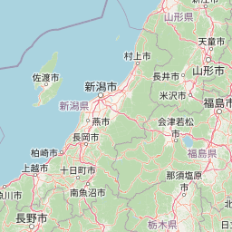
Map view of Myōkō-Togakushi Renzan National Park

Use this park location map to pinpoint Myōkō-Togakushi Renzan National Park in Japan, understand its exact geographic position, and read its mapped placement within the surrounding landscape more clearly.

Pigeon | © OpenStreetMap contributors

Location context for Myōkō-Togakushi Renzan National Park

Nagano PrefectureNiigata Prefecture
Park atlas

Explore regional protected areas and volcanic mountain landscapes surrounding Myōkō-Togakushi Renzan National Park, comparing diverse alpine environments.

Discover Other National Parks Near Myōkō-Togakushi Renzan National Park in Japan's Alpine Region
After exploring Myōkō-Togakushi Renzan National Park's volcanic peaks and alpine terrain, browse a curated selection of other national parks and protected areas across central Japan. Compare their distinct mountain geographies, conservation landscapes, and regional spread to deepen your understanding of the Japanese Alps.
National parkJapan

Jōshin'etsu-kōgen National Park: Protected Landscape and Regional Geography Atlas

Explore the mapped boundaries and geographic identity of this national park.

Jōshin'etsu-kōgen National Park represents a vital protected area within Japan, offering rich opportunities for geographic discovery through its mapped landscape. This entry provides detailed context on its protected boundaries and its relation to the surrounding regional geography, perfect for atlas-based exploration of natural terrains and conservation landscapes. Understand the unique geographic setting of this important national park.

Area
1,481.94 km²
Established
1949
IUCN
II
Relief
Mountain
National parkKantō region

Oze National Park National Park: A Key Protected Landscape in the Kantō Region

Explore its mapped geography and protected area context.

Oze National Park is a designated national park in Japan's Kantō region, offering a prime example of a protected landscape. This page provides detailed insights into its geographic setting and mapped boundaries, contributing to a structured understanding of regional natural terrain. Users can delve into the park's specific identity as a conservation area and its significance within the broader atlas of Japanese geography and protected lands.

Area
372.22 km²
Established
2007
IUCN
V
Relief
Mixed relief
National parkTochigi Prefecture

Nikkō National Park: Discover its Protected Landscape and Regional Geography

Explore mapped boundaries and natural terrain within Tochigi Prefecture.

Understand Nikkō National Park as a key protected area within the geography of Tochigi Prefecture. This dedicated page provides an atlas-style overview of its natural landscape, mapped contours, and significance. Users can gain insights into the park's protected status and its placement within Japan's diverse natural regions, fostering a deeper appreciation for its geographic context.

Area
1,149.08 km²
Established
1934
IUCN
II
Relief
Mountain
National parkSaitama Prefecture

Chichibu-Tama-Kai National Park: Mapped Protected Landscape and Regional Geography

Explore the geographic identity of this national park.

Discover Chichibu-Tama-Kai National Park through its protected landscape features and geographic setting. This page provides detailed atlas context, focusing on the park's mapped boundaries and its contribution to the regional geography of Saitama Prefecture. Understand the unique character and structural significance of this national park for comprehensive geographic discovery.

Area
1,216 km²
Established
1950
IUCN
II
Relief
Mountain
Watercolor illustration of a mountain landscape with a lake, grasses, and flowers
National parkIshikawa Prefecture

Hakusan National Park: Sacred Mountain Protected Landscape in Ishikawa Prefecture

Mapped alpine terrain and volcanic geography for protected area discovery.

Hakusan National Park offers a unique exploration of Japan's sacred mountain heritage and alpine natural beauty. This protected landscape, centered on Mount Haku, features distinct volcanic terrain, crater lakes, and exceptional alpine flora. Users can explore the park's mapped boundaries, understand its place within Ishikawa Prefecture's geography, and appreciate its role as a significant UNESCO Biosphere Reserve for detailed atlas-based discovery.

Area
477 km²
Established
1962
IUCN
II
Relief
Mountain
Watercolor painting of green and pink mountain ranges with forested foreground and distant peaks.
National parkChūbu region

Minami Alps National Park: A Protected Alpine Wilderness in Japan's Chūbu Region

Discover its dramatic peaks and vital river headwaters.

Minami Alps National Park offers a profound exploration into Japan's high-altitude natural geography. As a national park, it preserves a dramatic alpine environment defined by glacially carved terrain and multiple peaks exceeding 3000 meters. This protected landscape serves as a vital watershed, safeguarding the origins of major river systems and showcasing a rugged mountain character distinct from more accessible areas, ideal for understanding protected wildlands.

Area
357.52 km²
Established
1964
IUCN
II
Relief
Mountain
National parkTōhoku region

Bandai-Asahi National Park: National Park Exploration and Geographic Context

Explore protected landscapes and mapped terrain in Japan's Tōhoku region.

Bandai-Asahi National Park provides critical insights into Japan's protected natural areas and regional geography. As a designated national park, it serves as a key entity for understanding mapped boundaries and landscape characteristics within the Tōhoku region. This page is designed for detailed atlas exploration, offering a focused view on the park's geography and its significance as a protected landscape.

Area
1,870.41 km²
Established
1950
IUCN
II
Visitors
7.1M annual
National parkJapan

Fuji-Hakone-Izu National Park: Japan's Premier National Park with Diverse Volcanic Landscapes and Mapped Geography

Explore volcanic terrain, hot springs, islands, and Mount Fuji's iconic protected boundaries.

Fuji-Hakone-Izu National Park is a vast and diverse protected area in Japan, anchored by the iconic Mount Fuji. This national park features a remarkable range of volcanic landscapes, including natural hot springs, rugged coastlines, and the unique Izu Islands extending into the Pacific. Delve into its mapped geography and protected landscape identity for a comprehensive atlas-style understanding of this significant natural asset within Japan.

Area
1,227 km²
Established
1936
IUCN
II
Visitors
11.3M annual

Common questions about visiting, size, designation, and location context for Myōkō-Togakushi Renzan National Park

Myōkō-Togakushi Renzan National Park FAQs for park facts, access, geography, and protected area context
Find quick answers about Myōkō-Togakushi Renzan National Park, including protected-area facts, park geography, trail and visitor context, and how the park fits into its surrounding country and regional landscape.
MoriAtlas Explorer

Continue Your Protected Areas Search Across the Global Atlas

Deepen your exploration by continuing the structured search for national parks and protected areas worldwide. Utilize the comprehensive filtering capabilities to compare different conservation landscapes and refine your understanding of global park geography. Discover more about the distribution and characteristics of protected natural areas.

Global natural geography