

Mori Atlas logo
National parkNaejangsan National Park

Explore the mapped boundaries and regional context of this national park.

Naejangsan National Park: A Protected Landscape in the Geography of South Korea

Naejangsan National Park represents a key protected landscape within the geography of South Korea. This page serves as an atlas entry point, detailing the park's geographic identity and its place within the nation's conservation network. Users can explore the mapped boundaries and understand the natural terrain that defines this significant protected area, offering a foundation for structured discovery.

National ParksSouth KoreaMountain ParksForest Protected AreasAutumn Foliage DestinationsBiodiversity Hotspots

Naejangsan National Park

National park

Park overview

Structured park overview, official facts, and landscape profile for Naejangsan National Park

Naejangsan National Park park facts, protected area profile, and essential visitor context
Review the core facts for Naejangsan National Park, including designation, size, terrain, visitor scale, habitats, and operating context in one park-focused overview.

About Naejangsan National Park

Naejangsan National Park occupies a significant position in South Korea's system of protected areas, representing the mountainous landscapes and forest ecosystems of the southwestern peninsula. The park's terrain is characterized by steep mountainous ridges and valleys that create a diverse array of microhabitats supporting the area's notable biodiversity. Naejangsan itself rises to 763 meters, but the surrounding peaks and ridgelines create an expansive protected landscape that extends across the provincial boundary between Jeollabuk-do and Jeollanam-do. The forest cover consists primarily of deciduous and mixed forest communities that undergo dramatic seasonal transformations, particularly in autumn when the park becomes a premier destination for foliage viewing. The combination of natural beauty, ecological significance, and spiritual heritage makes Naejangsan a distinctive national park that embodies multiple dimensions of Korean conservation and cultural values.

Quick facts and research context for Naejangsan National Park

Naejangsan National Park is located in southwestern South Korea across Jeollabuk-do and Jeollanam-do provinces. The park was established in 1971 as the eighth of South Korea's national parks and covers 81.45 square kilometers around Naejangsan mountain. The mountain rises to 763 meters and has historically served as a sacred Buddhist site, featuring several centuries-old temples. The park supports remarkable biodiversity with 919 documented plant species and 1,880 animal species, including twelve endangered species. The area is classified under IUCN Category II as a national park and is managed by the Korea National Park Service.

Park context

Deeper park guide and search-rich context for Naejangsan National Park

Naejangsan National Park history, landscape, wildlife, and travel context
Explore Naejangsan National Park through its history, landscape character, ecosystems, wildlife, conservation priorities, cultural context, and seasonal travel timing in a structured park guide built for atlas discovery and search intent.

Why Naejangsan National Park stands out

Naejangsan National Park is best known for its exceptional autumn color season, when the mountain's deciduous forests transform into vivid displays of red, orange, and gold foliage that draw visitors from across South Korea. Beyond its seasonal beauty, the park is recognized for its ecological diversity, supporting a remarkable concentration of species across its forested slopes and valley systems. The mountain's spiritual heritage is also a defining characteristic, with historic Buddhist temples integrated into the landscape and contributing to the park's cultural identity.

Naejangsan National Park history and protected-area timeline

Naejangsan National Park was designated as South Korea's eighth national park on 17 November 1971, reflecting the country's growing commitment to preserving representative examples of its natural landscape. The establishment of the park came during a period when South Korea was systematically building its national park system, which had begun with the designation of Baekdu Mountain in 1966. The selection of Naejangsan for protected status recognized both the area's ecological significance and its cultural importance as a historic site of Buddhist worship. The mountain has been a sacred site for centuries, with temples established on its slopes serving as centers of spiritual practice and cultural preservation. The Korea National Park Service was designated as the governing body for managing the park, implementing conservation programs and visitor management frameworks that have evolved over the decades.

Naejangsan National Park landscape and geographic character

The landscape of Naejangsan National Park is defined by mountainous terrain with steep slopes, narrow valleys, and forested ridgelines characteristic of the hillslope topography found throughout southwestern South Korea. Naejangsan itself is the central peak, rising to 763 meters, but the park encompasses a broader network of adjacent ridges and valleys that create a complex and visually varied landscape. The valleys contain streams and small waterfalls that add to the scenic character, while the slopes support dense forest cover that changes dramatically with the seasons. The combination of the mountain's elevation, its forest cover, and the temple complexes nestled within the valleys creates a traditional Korean mountain landscape that has been celebrated in art and literature for centuries.

Naejangsan National Park ecosystems, habitats, and plant life

The ecological character of Naejangsan National Park is defined by its diverse forest ecosystems and the associated biodiversity they support. The park contains 919 documented plant species, representing a rich flora that includes both deciduous and evergreen species adapted to the temperate climate of the Korean peninsula. The forest communities provide critical habitat for the park's animal inhabitants, with 1,880 animal species documented within the boundaries. Twelve of these animal species are classified as endangered, highlighting the park's significance as a refuge for species of conservation concern. The combination of elevation variation, forest types, and the presence of water features in the valleys creates a mosaic of habitats that supports this remarkable diversity.

Naejangsan National Park wildlife and species highlights

Naejangsan National Park supports a significant animal community with 1,880 documented species, including twelve endangered species that receive special conservation attention. The forest-dwelling fauna includes various mammal, bird, reptile, amphibian, and insect species that depend on the park's woodland habitats for survival. The presence of endangered species underscores the ecological importance of the protected area and its role in maintaining biodiversity in the southwestern Korean peninsula. The diverse habitats created by the mountain's topography, from valley streams to ridgeline forests, support different animal communities throughout the park.

Naejangsan National Park conservation status and protection priorities

As South Korea's eighth national park and an IUCN Category II protected area, Naejangsan National Park serves important conservation functions for the southwestern region of the Korean peninsula. The park protects significant forest ecosystems and the biodiversity they contain, including twelve endangered animal species. The protected status helps maintain ecological processes and species populations that might otherwise face pressure from development or resource extraction. The park also preserves a landscape of cultural and spiritual significance, where the integration of natural and cultural values reflects traditional Korean approaches to mountain stewardship. Management by the Korea National Park Service ensures ongoing protection and sustainable visitor access.

Naejangsan National Park cultural meaning and human context

Naejangsan National Park contains significant cultural heritage elements, particularly the Buddhist temples that have been established on the mountain's slopes over centuries. These temple complexes are active religious sites that contribute to the park's identity and provide a cultural dimension that complements its natural features. The mountain has been a place of spiritual practice and pilgrimage, with the temples serving as centers of worship, meditation, and cultural preservation. This religious heritage has shaped the landscape over generations, with temple buildings, stone monuments, and associated traditions becoming integral to the character of Naejangsan.

Top sights and standout views in Naejangsan National Park

Naejangsan National Park stands out for its exceptional autumn foliage season, when the mountain's forests display vivid colors that rank among the most celebrated in South Korea. The park's biodiversity, with 919 plant species and 1,880 animal species including twelve endangered species, represents a remarkable concentration of life in a relatively compact protected area. The historic Buddhist temples within the park add cultural depth, creating a landscape where natural and spiritual heritage interweave. The mountain's 763-meter summit offers hiking opportunities through diverse forest environments, while the valley temples provide cultural and contemplative spaces for visitors.

Best time to visit Naejangsan National Park

The optimal time to visit Naejangsan National Park is during the autumn season, typically from mid-October to early November, when the deciduous forests display their characteristic vibrant foliage in reds, oranges, and golds. This autumn color season is the park's most famous attraction and draws significant visitor numbers. Spring offers another appealing season, with cherry blossoms and fresh green foliage emerging across the slopes. Summer brings lush forest cover but also larger visitor crowds and warmer conditions. Winter provides a quieter experience with bare trees revealing mountain contours, though trail conditions may be more challenging. The choice of season depends on whether visitors prioritize the renowned autumn colors, spring flowers, or the solitude of quieter months.
Park location guide

Geography guide, regional context, and park location map for Naejangsan National Park

Naejangsan National Park park geography, regions, and map view in South Korea
Understand where Naejangsan National Park sits in South Korea through a broader geographic reading of the surrounding landscape, nearby location context, and its mapped position within the national park landscape.

How Naejangsan National Park fits into South Korea

South Korea is a presidential republic on the Korean Peninsula in East Asia. It has a population of about 51 million and Seoul as its capital and largest city. The country is known for its rapid economic development, high technology industry, and cultural exports.

Wider geography shaping Naejangsan National Park in South Korea

South Korea occupies the southern half of the Korean Peninsula in East Asia. It borders North Korea along the Demilitarized Zone to the north, the Yellow Sea to the west, and the Sea of Japan to the east. The terrain is predominantly mountainous with coastal plains along the southern and eastern shores.

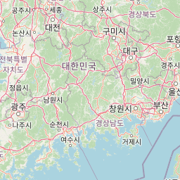
Map view of Naejangsan National Park

Use this park location map to pinpoint Naejangsan National Park in South Korea, understand its exact geographic position, and read its mapped placement within the surrounding landscape more clearly.

Pigeon | © OpenStreetMap contributors

Location context for Naejangsan National Park

Jeollabuk-doJeollanam-do
Park atlas

Trace surrounding mountain landscapes, forest protected areas, and regional conservation sites.

National Parks Near Naejangsan National Park, South Korea: Discover Nearby Protected Areas
After exploring Naejangsan National Park's unique mountain landscape and rich biodiversity, browse other national parks and protected areas across the surrounding region of South Korea. Compare their distinct geographic features, forest types, and conservation priorities to understand the wider network of protected landscapes.
National parkJeollanam-do

Mudeungsan National Park: Mapped Protected Landscape and Regional Geography Context

Explore Mudeungsan National Park's geographic setting in Jeollanam-do.

Mudeungsan National Park offers a distinct protected landscape within the Jeollanam-do region of South Korea. This atlas-focused page details its mapped geographic boundaries and the surrounding natural terrain, providing essential context for understanding its role as a national park. Explore the park's identity through its unique landscape and regional geography.

Area
75.45 km²
Established
2012
IUCN
II
Relief
Mountain
National parkJeollabuk-do

Byeonsan-bando National Park: Protected Landscape and Geographic Context in Jeollabuk-do

Explore mapped terrain and regional park geography.

This detail page provides an in-depth look at Byeonsan-bando National Park, a protected area located in South Korea's Jeollabuk-do region. Users can discover the park's specific geographic identity, understand its mapped boundaries, and explore its role within the broader regional landscape. The content is structured for atlas exploration, offering detailed insights into the park's natural terrain and its significance as a national park.

Area
154.71 km²
Established
1988
IUCN
II
Relief
Mixed relief
National parkSouth Korea

Jirisan National Park: South Korea's Premier Protected Landscape and Map Resource

Explore the mapped terrain and protected area geography.

Jirisan National Park is a key protected area within South Korea, serving as a vital component of the nation's natural landscape. This atlas-focused content provides detailed geographic information, highlighting the park's mapped boundaries and its role within the regional context of the Korean Peninsula. Understand the distinct characteristics of this protected national park for comprehensive geographic discovery.

Area
471.75 km²
Established
1967
IUCN
II
Visitors
1.5M annual
National parkJeollanam-do

Wolchulsan National Park: Detailed Geographic and Protected Landscape Atlas Entry

Explore mapped boundaries and natural terrain context.

This MoriAtlas entry for Wolchulsan National Park provides a detailed look at its identity as a protected landscape within Jeollanam-do, South Korea. Focus is placed on its geographic context and mapped park boundaries, offering a foundation for understanding its place in the regional atlas. Discover the structured details of this national park's natural terrain and its significance as a preserved natural area.

Area
56.6 km²
Established
1988
IUCN
II
Relief
Mountain
National parkJeollabuk-do

Deogyusan National Park: National Park Identity and Geographic Mapping

Explore its protected land boundaries and regional landscape context.

Examine Deogyusan National Park, a designated national park situated in the Jeollabuk-do region of South Korea. This entry provides critical geographic context, focusing on the park's mapped boundaries and its role as a protected landscape. Users can gain a structured understanding of its natural terrain and regional significance, contributing to a broader atlas of protected areas.

Area
231.65 km²
Established
1975
IUCN
V
Visitors
1M annual
National parkChungcheongnam-do

Gyeryongsan National Park: Mapped Protected Landscape in Chungcheongnam-do

Explore its national park designation and regional geography.

Gyeryongsan National Park is a formally protected national park in Chungcheongnam-do, South Korea. This page offers critical atlas context for understanding the park's geographic scope, mapped protected boundaries, and its significance as a natural landscape within the region. Examine the terrain and explore its regional context for a deeper appreciation of its protected status.

Area
64.71 km²
Established
1968
IUCN
II
Relief
Mountain
National parkSouth Gyeongsang Province

Gayasan National Park: National Park Identity and Mapped Geographic Context in South Korea

Discover Protected Landscape and Regional Terrain

Gayasan National Park presents a distinct protected-area entity within South Gyeongsang Province, serving as a crucial point for atlas-driven geographic exploration. As a designated national park in South Korea, it offers insights into its specific mapped boundaries and the surrounding natural terrain. Understanding this park's role within the regional geography provides a foundational element for comprehending broader landscape patterns and protected land distribution across the country.

Area
167.6 km²
Established
1972
IUCN
II
Relief
Mountain
National parkSouth Korea

Hallyeohaesang National Park: South Korea National Park Geographic Atlas Entry

Explore mapped protected area boundaries and natural terrain.

As a designated national park in South Korea, Hallyeohaesang National Park offers a distinct geographic profile crucial for atlas exploration. This entry focuses on its protected landscape features, mapped territorial extent, and regional context within the Republic of Korea. Understand the park's specific geographical markers and its significance as a mapped protected area.

Area
545.63 km²
Established
1968
IUCN
II
Access
Access unknown

Common questions about visiting, size, designation, and location context for Naejangsan National Park

Naejangsan National Park FAQs for park facts, access, geography, and protected area context
Find quick answers about Naejangsan National Park, including protected-area facts, park geography, trail and visitor context, and how the park fits into its surrounding country and regional landscape.
MoriAtlas Explorer

Continue Your Protected Areas Search Across the Global Atlas

Deepen your exploration by continuing the structured search for national parks and protected areas worldwide. Utilize the comprehensive filtering capabilities to compare different conservation landscapes and refine your understanding of global park geography. Discover more about the distribution and characteristics of protected natural areas.

Global natural geography