

Mori Atlas logo
National parkNaracoorte Caves National Park

Discover the mapped natural geography and protected area context of this South Australian national park.

Naracoorte Caves National Park: Protected Landscape Atlas in South Australia

(Naracoorte Caves Complex)

Naracoorte Caves National Park stands as a distinct protected landscape within the vast geography of South Australia. This page offers a detailed atlas-style exploration of its significance as a national park, focusing on its mapped boundaries, unique natural features, and its place within the regional context of Australia. Understand the core identity of this protected area and its contribution to the mapped natural heritage of South Australia.

fossil sitesUNESCO World Heritagelimestone cavesSouth AustraliamegafaunaPleistocene fossils

Naracoorte Caves National Park

National park

Park overview

Structured park overview, official facts, and landscape profile for Naracoorte Caves National Park

Naracoorte Caves National Park park facts, protected area profile, and essential visitor context
Review the core facts for Naracoorte Caves National Park, including designation, size, terrain, visitor scale, habitats, and operating context in one park-focused overview.

About Naracoorte Caves National Park

Naracoorte Caves National Park represents one of Australia's most important paleontological treasures, preserving a window into the continent's prehistoric past through its extensive fossil record. The park's limestone cave system was formed through the dissolution and erosion of limestone bedrock by groundwater over millions of years, creating a complex network of chambers and passages that have served as natural traps for fauna. The fossil accumulation occurred as animals fell through openings in the cave ceiling, becoming trapped and their remains subsequently preserved in layers of eroded topsoil washed and blown into the caves over hundreds of thousands of years. This process created stratified deposits that scientists can use to reconstruct the sequence of faunal changes over time, providing invaluable insights into Australian ecosystems before and during the Pleistocene era. The park's combination of accessible show caves featuring dramatic formations and protected scientific caves containing fossils makes it unique among the world's fossil sites.

Quick facts and research context for Naracoorte Caves National Park

Located near the town of Naracoorte in south-eastern South Australia, the park covers approximately 6.6 square kilometres of remnant vegetation. The World Heritage Area encompasses 3.05 square kilometres containing 26 caves, with fossil-bearing sediment deposits reaching up to 20 metres thick in some locations. The caves served as natural traps, collecting mammals and other creatures that fell into open shafts over millennia, preserving an extraordinarily detailed record of Pleistocene fauna. The park transitioned from a Forest Reserve in 1885, to a Conservation Park in 1972, and finally achieved National Park status in 2001, reflecting its growing recognition as a site of national and international significance.

Park context

Deeper park guide and search-rich context for Naracoorte Caves National Park

Naracoorte Caves National Park history, landscape, wildlife, and travel context
Explore Naracoorte Caves National Park through its history, landscape character, ecosystems, wildlife, conservation priorities, cultural context, and seasonal travel timing in a structured park guide built for atlas discovery and search intent.

Why Naracoorte Caves National Park stands out

The park is internationally significant for its fossil deposits representing Australian megafauna from the Pleistocene epoch. The Victoria Fossil Cave contains the largest known Australian Pleistocene vertebrate fossil cave deposit, discovered in 1969. Notable species preserved here include the marsupial lion (Thylacoleo carnifex), giant wombat-like diprotodon, and ancestral thylacine. The caves also feature spectacular limestone formations including towering stalactites and stalagmites, with some dating back at least 1.34 million years. The Wonambi Fossil Centre displays reconstructed skeletons and dioramas of extinct animals, bringing the prehistoric past to life for visitors.

Naracoorte Caves National Park history and protected-area timeline

The caves were first encountered by European settlers in 1845 with the discovery of Blanche Cave. In 1885, the Department of Woods and Forests appointed a caretaker to protect the caves from vandalism due to their growing popularity. The first documented collection of megafauna fossils occurred in 1908 when William Reddan recovered specimens from Specimen Cave, though this early collection lacked proper stratigraphic documentation. In 1916, control of approximately 20 hectares containing the major caves was transferred to the Immigration, Publicity and Tourist Bureau to manage as a national pleasure resort under the National Pleasure Resort Act 1914. This era lasted until 1972 when the site was proclaimed Naracoorte Caves Conservation Park under the new National Parks and Wildlife Act. The pivotal discovery in 1969 of the massive fossil deposit in Victoria Cave transformed scientific understanding of the site. On 17 December 1994, the park was inscribed on the UNESCO World Heritage List as part of the Australian Fossil Mammal Sites (Riversleigh/Naracoorte). The conservation park was abolished and reconstituted as Naracoorte Caves National Park on 18 January 2001, recognizing its national significance.

Naracoorte Caves National Park landscape and geographic character

The park sits within the Limestone Coast region of South Australia, characterized by gently undulating terrain formed from ancient marine sediments. The underlying limestone geology dates to two major periods of marine deposition: approximately 200 million years ago and again 20 million years ago when much of the area lay beneath sea level. The resulting limestone formations have been subsequently eroded by groundwater, creating the cave system that defines the park's character. The landscape features scattered remnant vegetation across the 6 square kilometres of the park, with the cave entrances appearing as openings in the gentle hillsides. The caves themselves contain spectacular geological formations including stalactites hanging from ceilings, stalagmites rising from floors, and intricate flowstones that have built up over millennia of mineral-rich water dripping through the limestone.

Naracoorte Caves National Park ecosystems, habitats, and plant life

The cave system supports a unique subterranean ecosystem despite its primary significance as a fossil site. The caves maintain consistent temperature and humidity conditions that preserve both geological formations and fossil materials. The surrounding remnant vegetation provides habitat for various native species while the cave interiors, particularly Bat Cave, support significant populations of southern bent-wing bats. These bats breed annually in the cave, utilizing the protected underground environment for shelter. The fossil-bearing sediments represent a complex ecological record showing the composition of fauna spanning multiple ice age cycles, with some deposits reaching 20 metres in thickness. The scientific value lies not just in the individual fossils but in the stratified layers that allow researchers to reconstruct chronological sequences of faunal change.

Naracoorte Caves National Park wildlife and species highlights

While the park is primarily celebrated for its fossil fauna, it also supports living wildlife within and around the cave system. The southern bent-wing bat (Miniopterus orianae bassanii) colonies in Bat Cave represent one of the most significant bat breeding colonies in southern Australia, with thousands of individuals using the cave annually. The park's surface areas contain remnant Australian native vegetation supporting common mammals, birds, and reptiles characteristic of the Limestone Coast region. However, the true wildlife significance lies in the fossil record, which preserves evidence of Australia's unique prehistoric fauna including giant marsupials, massive reptiles, and ancestral versions of living species. The Wonambi Fossil Centre displays reconstructed skeletons that showcase this lost fauna, including the marsupial lion, diprotodon, and various extinct kangaroo species.

Naracoorte Caves National Park conservation status and protection priorities

The park's conservation significance is recognized at multiple levels, from national legislation to international heritage designation. The UNESCO World Heritage inscription in 1994 acknowledged the site as one of the most significant fossil mammal sites in the world, providing irreplaceable evidence of mammalian evolution in Australia. The National Park status established in 2001 reflects domestic recognition of the site's importance requiring permanent protection. Many caves remain closed to the public to protect both the caves themselves and their scientific contents for ongoing research. Some fossil-bearing areas are preserved specifically for future scientific investigation when improved dating and analysis techniques may yield additional insights. The management approach balances public education through show caves with strict protection of areas essential for continued paleontological research.

Naracoorte Caves National Park cultural meaning and human context

The park's cultural context extends beyond its fossil significance to include the history of human interaction with the landscape. The caves have been used by people for thousands of years, with the Limestone Coast region being home to Aboriginal communities whose connections to these landscapes predate European settlement. The European discovery and subsequent management of the caves reflects changing attitudes toward natural heritage, evolving from early exploitation to systematic protection. The development from a tourism-focused national pleasure resort to a scientifically-managed national park demonstrates increasing recognition of the site's deeper significance. The Wonambi Fossil Centre, named after an extinct snake that once inhabited Australia, provides educational interpretation connecting visitors to the deep time scale of Australia's paleontological heritage.

Top sights and standout views in Naracoorte Caves National Park

The Victoria Fossil Cave stands as the park's scientific crown jewel, containing the largest known Australian Pleistocene vertebrate fossil deposit and featuring spectacular fossil displays. Blanche Cave, the first discovered and one of four open to the public, offers visitors the chance to see decorated chambers with impressive formations. The Bat Cave provides a living wildlife experience with thousands of southern bent-wing bats breeding annually, with modern technology allowing visitors to observe normally inaccessible interior areas. The Wonambi Fossil Centre presents interactive displays and dioramas featuring reconstructions of extinct megafauna, bringing the fossil record to life. The combination of accessible show caves, world-class fossil collections, and ongoing scientific research makes this one of Australia's most important natural heritage sites.

Best time to visit Naracoorte Caves National Park

The park can be visited year-round, with the Limestone Coast region experiencing mild temperate conditions. The show caves maintain comfortable temperatures inside regardless of external weather, making cave tours pleasant in both summer and winter. The peak visitor season typically coincides with South Australian school holidays, particularly autumn and spring. Wildlife viewing opportunities, such as observing the bat colony at dusk, may vary seasonally and visitors should check scheduled tour times. The Wonambi Fossil Centre provides indoor interpretation suitable for all weather conditions. For those seeking quieter visitation, weekdays outside holiday periods generally offer a more contemplative experience of this remarkable paleontological site.
Park location guide

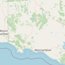
Geography guide, regional context, and park location map for Naracoorte Caves National Park

Naracoorte Caves National Park park geography, regions, and map view in Australia
Understand where Naracoorte Caves National Park sits in Australia through a broader geographic reading of the surrounding landscape, nearby location context, and its mapped position within the national park landscape.

How Naracoorte Caves National Park fits into Australia

Australia is a constitutional monarchy and federal parliamentary democracy comprising six states and ten territories. With a population of nearly 28 million, it is one of the world's most urbanised countries, with most people concentrated on the eastern seaboard. The country has a high Human Development Index and is known for its cultural diversity, ancient Aboriginal heritage, and unique wildlife.

Wider geography shaping Naracoorte Caves National Park in Australia

Australia occupies the entire Australian continent, the island of Tasmania, and numerous smaller islands. It is the world's flattest and driest inhabited continent, featuring vast deserts in the interior (the Outback), tropical rainforests along the eastern coast, and a coastline bordering the Indian and Pacific Oceans.

Map view of Naracoorte Caves National Park

Use this park location map to pinpoint Naracoorte Caves National Park in Australia, understand its exact geographic position, and read its mapped placement within the surrounding landscape more clearly.

Pigeon | © OpenStreetMap contributors

Location context for Naracoorte Caves National Park

Limestone CoastSouth Australia
Park atlas

Uncover regional protected areas and connected landscapes across South Australia's Limestone Coast

Explore Nearby National Parks and Protected Areas Near Naracoorte Caves National Park
After exploring Naracoorte Caves National Park, browse other significant national parks and protected areas across South Australia and its adjacent regions. This curated view allows for geographic comparison, tracing shared geological heritage, and understanding the broader spread of conservation landscapes.
National park

Little Desert National Park: Victoria's Semi-Arid National Park and Protected Landscape

Explore mapped boundaries and unique mallee heathland ecosystems.

Delve into the protected landscape of Little Desert National Park, a significant national park covering over 1,300 square kilometers of Victoria's semi-arid western region. This area is characterized by its deep sandy soils, mallee heathlands, and diverse wildlife, including important populations of native birds. Understanding its geographic setting and mapped boundaries provides crucial insight into Australia's conservation efforts and the preservation of unique desert ecosystems.

Area
1,326.47 km²
Established
1988
IUCN
II
Visitors
50K annual
National parkSouth Australia

Canunda National Park: South Australia's Protected Landscape and Geographic Atlas

Explore mapped boundaries and regional natural geography.

Canunda National Park in South Australia is presented here as a distinct protected landscape. This detail page focuses on its geographic setting, providing insights into its mapped boundaries and its role within the regional atlas context. Understand the park's natural geography and its protected status for informed exploration.

Area
96.24 km²
Established
1959
IUCN
VI
Relief
Lowland
National park

Lower Glenelg National Park: Dramatic River Gorge and Limestone Cave Protected Landscape

Explore its mapped boundaries and unique geological features.

Lower Glenelg National Park in Victoria, Australia, is a national park celebrated for its visually stunning Glenelg River gorge. This protected area showcases millions of years of geological history etched into its limestone cliffs and features the accessible Princess Margaret Rose Cave. Understand the park's mapped landscape, its diverse terrain from riverine woodlands to coastal wetlands, and its significance within regional geographic exploration.

Area
273 km²
Established
1969
IUCN
II
Visitors
200K annual
National parkBarwon South West

Cobboboonee National Park: A Protected Landscape in Australia's Barwon South West Region

Explore its mapped geography and natural terrain.

Cobboboonee National Park represents an important protected area within the Barwon South West region of Australia. This destination offers users a deep dive into the park's specific geography, providing context on its mapped boundaries and the surrounding natural landscapes. It is designed for exploration of the park's protected-area identity and its place within the regional geography, offering structured data for landscape context.

Area
185.1 km²
Established
2008
IUCN
II
Climate
Temperate
National park

Grampians National Park National Park: Sandstone Ranges and Aboriginal Heritage Atlas

Explore its mapped protected landscape and regional geography.

Grampians National Park stands as a testament to Victoria's natural and cultural heritage, featuring striking sandstone mountain ranges and an exceptional concentration of Aboriginal rock art sites. This protected area offers a deep dive into the region's unique geology, from its ancient sedimentary rock formations to its dramatic cliff faces and peaks. Understanding the park's mapped boundaries and its place within the broader geography provides essential context for appreciating its protected landscape identity and its millennia-long human history.

Area
1,672.19 km²
Established
1984
IUCN
II
Relief
Mountain
National park

Mount Richmond National Park: Protected Area Atlas and Southwest Victoria Landscape

Explore mapped terrain and coastal woodland ecosystems.

Mount Richmond National Park is a vital protected area in Victoria's southwest, safeguarding coastal woodland and heath remnants on the region's volcanic plains. As a component of Victoria's national park system, it provides a geographically specific example of a protected landscape, contributing to the regional atlas of natural environments. Its landscape character is defined by eucalyptus woodlands and coastal influences, offering context for understanding conservation corridors and the mapped natural terrain of the southwestern Victorian coast. The park’s inclusion in long-distance walking routes also underscores its value for exploring protected natural areas.

Area
17.33 km²
Established
1960
IUCN
II
Relief
Mixed relief
National park

Budj Bim National Park: Ancient Volcanic Landscapes and World Heritage Protected Area

Explore the unique geography of Budj Bim National Park's crater lakes and lava tubes.

Budj Bim National Park offers an exceptional exploration of volcanic geography and ancient human ingenuity. This protected area features a dramatic landscape dominated by volcanic cones, lava tubes, and the picturesque Lake Surprise crater lake. Its significance is amplified by the presence of sophisticated Aboriginal aquaculture systems, developed thousands of years ago by the Gunditjmara people, which have contributed to its UNESCO World Heritage status. Discover the mapped terrain and protected land context of this geologically and culturally rich Australian national park.

Area
54.7 km²
Established
1960
IUCN
II
Relief
Mixed relief
National park

Discovery Bay Marine National Park: Victoria's Protected Coastal Marine Landscape

Mapped protected waters adjacent to Cape Bridgewater's unique geography.

Discover the geographic scope and protected landscape identity of Discovery Bay Marine National Park, an important marine national park located in Victoria, Australia, near Portland. This protected area safeguards a crucial stretch of the country's southern coastline, contributing to the ecological significance of the Southern Ocean marine region. Its position adjacent to the Discovery Bay Coastal Park highlights an integrated conservation approach, offering users a detailed view of its mapped marine boundaries and the distinctive geological context of the Cape Bridgewater area for atlas exploration.

Area
27.7 km²
Established
2002
IUCN
II
Climate
Temperate

Common questions about visiting, size, designation, and location context for Naracoorte Caves National Park

Naracoorte Caves National Park FAQs for park facts, access, geography, and protected area context
Find quick answers about Naracoorte Caves National Park, including protected-area facts, park geography, trail and visitor context, and how the park fits into its surrounding country and regional landscape.
MoriAtlas Explorer

Continue Your Protected Areas Search Across the Global Atlas

Deepen your exploration by continuing the structured search for national parks and protected areas worldwide. Utilize the comprehensive filtering capabilities to compare different conservation landscapes and refine your understanding of global park geography. Discover more about the distribution and characteristics of protected natural areas.

Global natural geography