Mori Atlas logo
National parkNarawntapu National Park

Discover the mapped boundaries and diverse terrain of this significant Tasmanian national park.

Narawntapu National Park: Coastal Protected Landscape & Marsupial Wildlife Atlas

Narawntapu National Park, situated on Tasmania's north coast, offers a rich tapestry of protected landscapes for atlas exploration. This national park encompasses diverse terrain from coastal headlands and heathlands to woodlands and expansive intertidal mudflats, providing critical habitats for numerous marsupial species and migratory birds. Delve into its geography to understand the unique ecosystems and mapped boundaries that define this significant reserve within Australia's protected area network.

Coastal Protected AreaMarsupial WildlifeWetland Bird HabitatTasmania National ParksIntertidal MudflatsMigratory Bird Site

Narawntapu National Park

National park

Park overview

Structured park overview, official facts, and landscape profile for Narawntapu National Park

Narawntapu National Park park facts, protected area profile, and essential visitor context

Review the core facts for Narawntapu National Park, including designation, size, terrain, visitor scale, habitats, and operating context in one park-focused overview.

About Narawntapu National Park

Narawntapu National Park represents a significant protected coastal ecosystem on Tasmania's northern shoreline, spanning approximately 43 square kilometres between the town of Port Sorell and the estuary mouth of the Tamar River where it meets Bass Strait. The park's landscape encompasses a remarkable diversity of habitats within a relatively compact area, including coastal heathland, dry sclerophyll woodland, herbland, grassland, and salt marsh communities that transition into extensive intertidal mudflats along the estuary edges. Several islands within the Port Sorell estuary fall within the park's boundaries, including the Carbuncle, contributing to the protected area's ecological complexity. The park lies approximately 20 kilometres east of Devonport, 60 kilometres north-west of Launceston, and 250 kilometres north of Hobart, positioning it as an accessible nature destination for visitors traveling through Tasmania's north. The coastal location exposes the park to temperate maritime weather patterns, with prevailing winds from the north-east and north-west bringing most rainfall during the winter months. The highest terrain within the park reaches 392 metres above sea level, providing subtle elevation changes across the landscape rather than dramatic mountain terrain. Narawntapu's protection extends to the low water mark, ensuring the intertidal ecosystems remain undisturbed and continue supporting the rich birdlife and marine life that depend on these productive coastal wetlands.

Quick facts and research context for Narawntapu National Park

Narawntapu National Park covers 43.49 square kilometres along Tasmania's north coast, adjoining Bass Strait between Port Sorell and the Tamar River estuary. The park was established in 1976 and renamed in 2000, with its highest point reaching 392 metres above sea level. It is managed by the Tasmania Parks and Wildlife Service and is listed on Australia's Register of the National Estate. The visitor centre at Springlawn provides opportunities to observe forester kangaroos, Bennett's wallabies, and Tasmanian pademelons in their natural setting. The park encompasses islands in the Port Sorell estuary including the Carbuncle, and includes significant intertidal mudflat areas that support migratory bird populations.

Protection and recognition

Official management boundaries and designated protection records for coastal Tasmanian reserves

Documented Protection Status and Legal Designation of Narawntapu National Park

Official records outline the registered protection scope and formal designation history of Narawntapu National Park following its establishment in the year 2000. Accessing verified registry data like the World Database on Protected Areas helps clarify how regional conservation frameworks catalog coastal Tasmanian habitats.

Protection details

Protection scope
Mixed
Designated year
2000
WDPA ID
101802
Park context

Deeper park guide and search-rich context for Narawntapu National Park

Narawntapu National Park history, landscape, wildlife, and travel context

Explore Narawntapu National Park through its history, landscape character, ecosystems, wildlife, conservation priorities, cultural context, and seasonal travel timing in a structured park guide built for atlas discovery and search intent.

Why Narawntapu National Park stands out

Narawntapu is particularly renowned for its exceptional density of marsupial wildlife, with visitors commonly encountering forester kangaroos, Bennett's wallabies, Tasmanian pademelons, common wombats, and Tasmanian devils in open grassland areas near the Springlawn visitor precinct. The park's intertidal mudflats in the North East Arm area form part of the Rubicon Estuary Important Bird Area, supporting significant populations of migratory waders including pied oystercatchers. The coastal heathland and sclerophyll woodland habitats support threatened bird species such as the hooded plover, Tasmanian wedge-tailed eagle, and swift parrot, making the park a notable location for birdwatching and wildlife observation within Tasmania.

Narawntapu National Park history and protected-area timeline

The land that now constitutes Narawntapu National Park was first reserved as a protected area on 29 June 1976, initially designated as Asbestos Range National Park in reference to the nearby Asbestos Range geological formation. However, park managers and tourism authorities grew concerned that the word asbestos carried negative connotations that discouraged potential visitors from exploring the area, despite the name referring only to the geological feature and not to any actual asbestos deposits. Following a formal review process, the park was renamed to Narawntapu in the year 2000, adopting a name of Tasmanian Aboriginal origin that specifically references the coastal promontories of West Head and Badger Head within the park's boundaries. This renaming represented a broader movement within Australian protected areas toward acknowledging and preserving indigenous place names and cultural heritage. The park was formally listed on Australia's Register of the National Estate, recognizing its significance as a protected landscape of national importance. The establishment of visitor facilities at Springlawn has enabled tourists to observe native wildlife in accessible settings, with the area becoming particularly popular among visitors arriving from Devonport and Port Sorell. The park's conservation history includes management challenges related to wildlife disease, notably a mange outbreak among common wombat populations that began in 2010 and significantly impacted the species' numbers within the park by 2019.

Narawntapu National Park landscape and geographic character

The physical landscape of Narawntapu National Park presents a varied coastal terrain characterised by low to moderate elevation undulating terrain rising to a maximum of 392 metres above sea level. The park's eastern boundary follows the coastline of Bass Strait, where coastal headlands such as West Head and Badger Head project into the sea, creating distinctive promontories that the park's Aboriginal name references. The Port Sorell estuary cuts into the coastline on the western side of the park, introducing tidal influences and creating the extensive intertidal mudflat environments that characterise the North East Arm area. The Carbuncle and other smaller islands within the estuary fall within park boundaries, adding aquatic and island habitats to the protected area's diversity. The terrain transitions from coastal heathland on exposed headlands through drier sclerophyll woodland on the more sheltered slopes to grassland plains in the valley floors and wetland margins. Salt marsh communities occupy the transitional zones between terrestrial and aquatic environments, particularly around the estuary margins where tidal influence creates brackish conditions. The combination of coastal promontories, island environments, woodland ridges, and wetland flats creates a landscape of considerable visual and ecological variety within a relatively compact protected area.

Narawntapu National Park ecosystems, habitats, and plant life

The ecological character of Narawntapu is defined by a mosaic of vegetation communities that reflect the park's coastal location and temperate climate. Coastal heathland dominates the exposed headland areas, characterised by drought-resistant shrubs adapted to salt-laden winds and relatively poor soils. Dry sclerophyll woodland covers the more sheltered slopes and ridges, with eucalyptus species forming an open canopy above a diverse understory of grasses and shrubs. Herbland and grassland communities occupy the valley floors and areas surrounding wetlands, providing the open grassy plains that have become famous for their abundant marsupial populations. Salt marsh vegetation fringe the estuary edges, tolerating the periodic inundation and brackish conditions that characterise these transitional environments. The rare pygmy clubmoss has been recorded within the park, representing a species of particular botanical interest. The intertidal mudflats represent one of the park's most ecologically significant features, supporting highly productive benthic communities that form the base of food chains supporting vast numbers of migratory shorebirds. The Rubicon Estuary system, of which Narawntapu's mudflats form a part, has been identified as an Important Bird Area by BirdLife International due to its international significance for migratory wader species.

Narawntapu National Park wildlife and species highlights

Narawntapu National Park supports an exceptional concentration of marsupial species, making it one of Tasmania's most wildlife-rich protected areas. The Springlawn visitor area provides reliable sightings of forester kangaroos, Bennett's wallabies, and Tasmanian pademelons that graze openly on the grassland plains, often congregating in considerable numbers. Common wombats inhabit the park's woodland and heathland areas, though their populations have been severely affected by a mange outbreak that began in 2010 and reduced the population to between 3 and 10 individuals by 2019. Tasmanian devils, the iconic marsupial carnivore of Tasmania, are also present within the park and can be observed, particularly at dawn and dusk. Smaller marsupials including eastern quolls and spotted-tail quolls occupy the diverse habitats across the park, while monotremes such as platypus and short-beaked echidnas add to the mammalian diversity. The birdlife is particularly notable, with the intertidal mudflats supporting internationally significant populations of migratory waders including pied oystercatchers that travel between Tasmania and northern hemisphere breeding grounds. Threatened bird species including the hooded plover, Tasmanian wedge-tailed eagle, and swift parrot nest and forage within the park's various habitats. Wetland areas support diverse waterbird assemblages including several duck species, herons, swans, cormorants, coots, black-backed bitterns, and grebes, particularly during seasonal gatherings.

Narawntapu National Park conservation status and protection priorities

The conservation significance of Narawntapu National Park extends beyond its role as a protected area within Tasmania's national park network. The park's intertidal mudflats form a critical component of the Rubicon Estuary Important Bird Area, recognised internationally for their importance to migratory shorebird populations that depend on these productive feeding grounds during their annual migrations between southern Australia and northern hemisphere breeding areas. The presence of threatened bird species including the hooded plover, Tasmanian wedge-tailed eagle, and swift parrot demonstrates the park's importance as habitat for species of conservation concern. The diverse vegetation communities, ranging from coastal heathland through sclerophyll woodland to salt marsh, represent relatively intact examples of Tasmania's coastal ecosystems. The park's listing on Australia's Register of the National Estate reflects its recognition as a place of national environmental significance. Management efforts have addressed wildlife disease challenges, with scientific teams implementing treatment programs for wombats affected by mange, though these efforts were ultimately unsuccessful in preventing the deaths of infected individuals. The protection of coastal and wetland habitats ensures the continuation of ecological processes that support both resident and migratory species.

Narawntapu National Park cultural meaning and human context

The name Narawntapu carries deep cultural significance, derived from Tasmanian Aboriginal language and specifically referencing the coastal promontories of West Head and Badger Head that form prominent landscape features within the park. This naming reflects the long history of Aboriginal occupation and connection to the Tasmanian coastline, with the coastal areas providing traditional food resources and cultural significance for local indigenous communities. The park's 2000 renaming from Asbestos Range National Park acknowledged indigenous heritage while addressing practical concerns about visitor perception. The landscape has been shaped by both natural processes and historical human activity, with the coastal location providing contexts for settlement, fishing, and other traditional land uses that predate European colonisation of Tasmania. The cultural layer adds depth to the park's identity beyond its ecological values, connecting contemporary protected area management with the longer human history of the Tasmanian coastline.

Top sights and standout views in Narawntapu National Park

Narawntapu National Park offers distinctive wildlife viewing opportunities at the Springlawn visitor area where forester kangaroos, Bennett's wallabies, and Tasmanian pademelons can be observed grazing in open grassland settings. The coastal headlands of West Head and Badger Head provide scenic lookouts over Bass Strait and the estuary waters below. The intertidal mudflats of the North East Arm support remarkable concentrations of migratory shorebirds, particularly pied oystercatchers, making this a significant destination for birdwatching enthusiasts. The diversity of habitats within a relatively compact area allows visitors to experience heathland, woodland, grassland, and wetland environments in a single visit. The park's accessibility from Devonport and Port Sorell makes it a convenient destination for visitors exploring Tasmania's north coast.

Best time to visit Narawntapu National Park

Narawntapu National Park experiences a temperate maritime climate with characteristic mild temperatures and mainly winter rainfall, making it suitable for visits throughout the year. Mean summer temperatures reach around 17 degrees Celsius in January, while winter temperatures average around 9 degrees Celsius in July, providing comfortable conditions for outdoor exploration in most seasons. The prevailing north-east and north-west winds influence visitor comfort, with spring and autumn often presenting calmer conditions. Winter rainfall can make some tracks muddy and less suitable for walking, though the park remains accessible. The summer months typically offer longer daylight hours for wildlife viewing and landscape appreciation, while the winter season brings fewer visitors and opportunities for more solitary exploration of the park's trails and observation areas.
Park guides

Essential visit planning insights for Tasmania's coastal protected landscape

Narawntapu National Park Focused Guides and Practical Planning Resources

Focused reference resources help visitors navigate specific questions regarding protected coastal terrain and seasonal conditions. Published guides examine visit timing, seasonal weather patterns, and optimal periods for observing marsupial wildlife.
Monthly climate preview

Explore long-term average temperatures and precipitation trends in northern Tasmania.

Narawntapu National Park Climate Normals and Monthly Weather Patterns

Long-term climate data at the representative elevation shows monthly mean temperatures spanning from 9.5 to 17.3 degrees Celsius alongside distinct daily precipitation patterns. Comparing the full twelve-month profile reveals seasonal temperature ranges and subtle moisture shifts across the northern Tasmanian coast.
Annual mean13 °C
10 °C17 °C
Jan17°
Feb17°
Mar16°
Apr14°
May12°
Jun10°
Jul10°
Aug10°
Sep10°
Oct12°
Nov13°
Dec15°
Warmest month
February

17.3 °C

Coolest month
August

9.6 °C

Wettest month
August

3.4 mm/day

Driest month
February

1.5 mm/day

Park location guide

Geography guide, regional context, and park location map for Narawntapu National Park

Narawntapu National Park park geography, regions, and map view in Australia

Understand where Narawntapu National Park sits in Australia through a broader geographic reading of the surrounding landscape, nearby location context, and its mapped position within the national park landscape.

How Narawntapu National Park fits into Australia

Australia is a constitutional monarchy and federal parliamentary democracy comprising six states and ten territories. With a population of nearly 28 million, it is one of the world's most urbanised countries, with most people concentrated on the eastern seaboard. The country has a high Human Development Index and is known for its cultural diversity, ancient Aboriginal heritage, and unique wildlife.

Wider geography shaping Narawntapu National Park in Australia

Australia occupies the entire Australian continent, the island of Tasmania, and numerous smaller islands. It is the world's flattest and driest inhabited continent, featuring vast deserts in the interior (the Outback), tropical rainforests along the eastern coast, and a coastline bordering the Indian and Pacific Oceans.

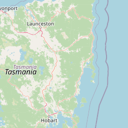
Map view of Narawntapu National Park

Use this park location map to pinpoint Narawntapu National Park in Australia, understand its exact geographic position, and read its mapped placement within the surrounding landscape more clearly.

Pigeon | © OpenStreetMap contributors

Location context for Narawntapu National Park

Tasmania
Natural feature types

Examine the Mapped Geography and Natural Features of Narawntapu National Park

Use MoriAtlas to navigate the specific landforms and coastal environments that define the character of Narawntapu National Park. This structured collection offers a deeper geographic understanding of the park's coastal headlands, estuarine mudflats, and surrounding natural terrain.
Recorded earthquake history

Review the Historical Earthquake Catalogue for Narawntapu National Park

Access a detailed archive of recorded seismic activity occurring near Narawntapu National Park. This MoriAtlas dataset allows for the examination of historical earthquake events, providing clear data points on magnitude and distance from the park borders for comprehensive regional geographic understanding.

Narawntapu National Park Earthquake History

Catalogued events

1 event

Strongest magnitude

Magnitude 4

Most recent event

Aug 23, 1997

This history includes earthquakes recorded inside the park or within 50 km of its borders

Park atlas

Trace the geographic spread of protected areas and landscapes adjacent to Narawntapu National Park.

Continue Your Park Discovery: National Parks and Protected Areas Near Narawntapu National Park

Explore national parks and protected areas located in the wider region surrounding Narawntapu National Park, encompassing diverse coastal habitats, woodlands, and unique marsupial ecosystems found across Tasmania. Compare their geographic features, conservation status, and ecological significance to gain broader context on Tasmania's network of protected landscapes and find your next area for exploration.
National parkTasmania
46 km away#1 closest

Southwest

Mole Creek Karst National Park: Mapped Protected Area and Tasmanian Landscape Atlas

Explore the geography and park boundaries within Tasmania's protected lands.

Mole Creek Karst National Park stands as a key protected area within Tasmania, offering a unique glimpse into the island state's natural geography. This resource facilitates an atlas-style discovery of the park's mapped landscape, its protected boundaries, and its significance within the broader context of Australian protected lands. Understand the park's terrain and its role in the region's conservation heritage.

Area
13.45 km²
Established
1996
IUCN
II
Relief
Mountain
Nature reserveTasmania
About 60 km away#2 closest

South

Liffey Valley Reserve: Geographic Overview of a Tasmania Nature Reserve and Landscape

Protected sclerophyll forest and temperate rainforest sequences

Liffey Valley Reserve in Tasmania provides a focused look at how protected land boundaries align with natural elevation gradients. Its four component parcels protect a complete sequence of Tasmanian vegetation, spanning from ridge-top alpine heath to mossy rainforest depressions. This site acts as a key reference for understanding private conservation geography and the rugged terrain characterizing the eastern edge of the central highlands.

Area
2.75 km²
Established
1991
Water
Major water bodies
Season
Year-round
National parkTasmania
62 km away#3 closest

South

Walls of Jerusalem National Park: A Mapped Alpine Wilderness in Tasmania

Explore protected landscapes with biblical place names.

Walls of Jerusalem National Park in Tasmania is a distinguished national park characterized by its rugged alpine terrain and dramatic quartzite formations, most notably King Davids Peak. The park's landscape is further distinguished by a unique series of features named after biblical locations, offering an evocative exploration for those interested in geographic discovery. As a protected wilderness area within the Tasmanian Wilderness World Heritage Area, it provides valuable insight into Australia's significant natural landscapes and their mapped representation.

Area
518 km²
Established
1978
IUCN
II
Relief
Mountain
National parkTasmania
62 km away#4 closest

Southwest

Cradle Mountain, Lake St Clair National Park: Tasmania's Mapped Protected Landscape and Geography

Explore national park boundaries and regional natural terrain.

Gain insight into Cradle Mountain, Lake St Clair National Park, a protected national park in Tasmania, Australia. This entry provides a foundational understanding of its mapped terrain, geographic setting, and protected area status. Delve into the specific landscape characteristics that define this significant conservation zone and its place within the national atlas.

Area
1,614.43 km²
Established
1922
IUCN
II
Visitors
209K annual
National parkTasmania
83 km away#5 closest

West

Rocky Cape National Park: Tasmania's Coastal National Park with Ancient Aboriginal Heritage

Explore the dramatic headland, heath ecosystems, and mapped park boundaries.

Rocky Cape National Park on Tasmania's North West Coast is a nationally significant protected area recognized for its ancient Aboriginal archaeological heritage, representing at least 8,000 years of continuous occupation. The park's landscape unfolds across a dramatic coastal headland, featuring rugged rocky shores, expansive heathlands, and coastal woodlands that define this wild section of Tasmania. Its protected status underscores its importance for both cultural discovery and the preservation of unique Australian coastal ecosystems. Understanding Rocky Cape National Park offers direct insight into the region's geography and the enduring legacy of its first peoples.

Area
30.64 km²
Established
1967
IUCN
II
Relief
Lowland
Watercolor illustration showing a lake with distant mountains and vegetation
National parkAustralia
85 km away#6 closest

Southeast

Ben Lomond National Park: Tasmania's Premier Alpine Protected Landscape & Geography

Explore unique dolerite geology, plateau scenery, and alpine ecosystems.

Ben Lomond National Park is a premier alpine protected area within Australia, known for its dramatic dolerite geology and extensive plateau terrain. This national park offers a distinct mountain landscape shaped by glacial history, featuring notable peaks and significant alpine ecosystems. Discover the mapped boundaries and regional geographic context of this unique Australian protected land, understanding its place within the broader atlas of natural landscapes.

Area
162 km²
Established
1947
IUCN
II
Relief
Mountain
National parkTasmania
89 km away#7 closest

West

Savage River National Park: Discover Tasmania's Protected Landscape Geography

Explore mapped boundaries and regional park context.

Savage River National Park represents a distinct protected area within Tasmania, Australia, offering valuable insights into the island's natural geography and conservation landscape. As a designated national park, its mapped territory contributes to the understanding of regional protected areas and their distribution across Tasmania. This entity serves as a crucial point for atlas-based exploration, allowing users to grasp its geographic identity and its place within a broader map of Australian natural territories.

Area
179.8 km²
Established
1999
IUCN
II
Climate
Temperate
National parkTasmania
114 km away#8 closest

East

Mount William National Park: Protected Landscape and National Park Atlas Details

Discover mapped geography and protected area context within Tasmania.

Mount William National Park stands as a vital protected area within Tasmania's vast network of natural landscapes. This detailed entry focuses on its identity as a national park, providing essential geographic context and mapped boundaries for atlas exploration. Understanding Mount William National Park's place in Tasmania's regional geography allows for a richer appreciation of Australia's protected lands.

Area
184.39 km²
Established
1973
IUCN
II
Relief
Lowland

Common questions about visiting, size, designation, and location context for Narawntapu National Park

Narawntapu National Park FAQs for park facts, access, geography, and protected area context

Find quick answers about Narawntapu National Park, including protected-area facts, park geography, trail and visitor context, and how the park fits into its surrounding country and regional landscape.
MoriAtlas Explorer

Continue Your Protected Areas Search Across the Global Atlas

Deepen your exploration by continuing the structured search for national parks and protected areas worldwide. Utilize the comprehensive filtering capabilities to compare different conservation landscapes and refine your understanding of global park geography. Discover more about the distribution and characteristics of protected natural areas.

Global natural geography