
Mori Atlas logo
National parkNarrien Range National Park

Discover the geographic setting and mapped boundaries of this key national park.

Narrien Range National Park: A Mapped Protected Landscape in Queensland, Australia

Narrien Range National Park stands as a significant protected natural area within Queensland, Australia, offering a distinct geographic identity for exploration. This national park provides a focal point for understanding the region's mapped landscapes and the structured context of protected lands. Delve into the specific atlas attributes of Narrien Range National Park to grasp its unique place within the broader geography of northeastern Australia, emphasizing its role as a conservation landscape.

mountain reservesQueensland national parkscentral QueenslandIUCN Category IIprotected areasremote parks

Narrien Range National Park

National park

Park overview

Structured park overview, official facts, and landscape profile for Narrien Range National Park

Narrien Range National Park park facts, protected area profile, and essential visitor context

Review the core facts for Narrien Range National Park, including designation, size, terrain, visitor scale, habitats, and operating context in one park-focused overview.

About Narrien Range National Park

Narrien Range National Park protects a distinctive mountainous landscape in central Queensland, representing one of the more remote protected areas within the state's national park system. The park's core significance lies in its preservation of the Narrien Range, a collection of ridges and valleys that rise above the surrounding semi-arid plains characteristic of inland Queensland. This mountainous island of habitat exists within a broader landscape dominated by pastoral use, making the protected area an important refuge for native vegetation and wildlife that cannot survive in heavily modified grazing lands. The park's distance from major urban centers contributes to its wilderness character, with limited infrastructure and minimal visitation compared to more accessible Queensland national parks closer to the coast. Protection of this mountainous landscape ensures the preservation of geological features, native plant communities, and the ecological processes that sustain them within a region where development pressures continue to expand.

Quick facts and research context for Narrien Range National Park

Narrien Range National Park is located in central Queensland, Australia, occupying approximately 40.20 square kilometers of protected terrain centered on the Narrien Range. The park lies roughly 796 kilometers northwest of Brisbane, placing it within a remote section of the state far from major population centers. The area is classified under IUCN Category II as a national park, reflecting its primary purpose of preserving natural landscape and biodiversity. Management responsibility falls to the Queensland Parks and Wildlife Service, which administers the park as part of Queensland's statewide system of protected areas.

Protection and recognition

Tracking terrestrial management scope and regional conservation data

Narrien Range National Park Protected Area Profile and Designation Status

National park datasets provide verified insight into the terrestrial management scope and formal protection status of Narrien Range National Park. Reviewing official designation records helps researchers and conservationists map regional wilderness boundaries without relying on unverified international designations.

Protection details

Protection scope
Terrestrial
Transboundary protection
No
Monthly climate preview

Historical temperature ranges and daily precipitation patterns in Central Queensland

Narrien Range National Park Climate Normals and Monthly Weather Averages

Long-term records at 339 meters elevation show hot conditions peaking near forty degrees in December, contrasting with cooler, dry periods during June and July. Accessing the complete monthly profile reveals precise daily rainfall rates and detailed temperature bands for all twelve months in Narrien Range National Park.
Annual mean23 °C
15 °C28 °C
Jan28°
Feb27°
Mar26°
Apr23°
May19°
Jun16°
Jul15°
Aug17°
Sep21°
Oct25°
Nov27°
Dec28°
Warmest month
January

28 °C

Coolest month
July

15.3 °C

Wettest month
February

4 mm/day

Driest month
July

0.5 mm/day

Park location guide

Geography guide, regional context, and park location map for Narrien Range National Park

Narrien Range National Park park geography, regions, and map view in Australia

Understand where Narrien Range National Park sits in Australia through a broader geographic reading of the surrounding landscape, nearby location context, and its mapped position within the national park landscape.

How Narrien Range National Park fits into Australia

Australia is a constitutional monarchy and federal parliamentary democracy comprising six states and ten territories. With a population of nearly 28 million, it is one of the world's most urbanised countries, with most people concentrated on the eastern seaboard. The country has a high Human Development Index and is known for its cultural diversity, ancient Aboriginal heritage, and unique wildlife.

Wider geography shaping Narrien Range National Park in Australia

Australia occupies the entire Australian continent, the island of Tasmania, and numerous smaller islands. It is the world's flattest and driest inhabited continent, featuring vast deserts in the interior (the Outback), tropical rainforests along the eastern coast, and a coastline bordering the Indian and Pacific Oceans.

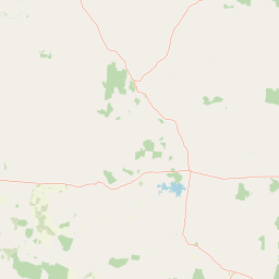
Map view of Narrien Range National Park

Use this park location map to pinpoint Narrien Range National Park in Australia, understand its exact geographic position, and read its mapped placement within the surrounding landscape more clearly.

Pigeon | © OpenStreetMap contributors

Location context for Narrien Range National Park

Queensland
Natural feature types

Browse the Detailed Geographic Collection for Narrien Range National Park

Examine the physical landmarks and natural terrain associated with Narrien Range National Park through our structured atlas. Gain a clearer understanding of the park landscape by navigating through mapped features and geological formations that exist within or adjacent to this remote Australian wilderness.
Park atlas

Browse more protected landscapes in Queensland's semi-arid interior, comparing their regional geography.

Discover Other National Parks and Protected Areas Near Narrien Range National Park

After exploring Narrien Range National Park, continue your geographic discovery by browsing other national parks and protected areas across central Queensland, Australia. Compare different mountainous landscapes, semi-arid terrains, and conservation zones to understand the regional spread of protected lands in this remote part of Australia.
National parkQueensland
55 km away#1 closest

West

Cudmore National Park: Mapped Protected Area in Queensland's Geography

Explore the unique landscape and regional context.

Cudmore National Park represents a distinct protected landscape within the vast geographic expanse of Queensland, Australia. This national park offers a valuable point of entry for understanding regional conservation efforts and the mapped distribution of protected lands. Examine its specific location within Queensland's natural terrain and appreciate its role in the broader atlas of Australian protected areas, focusing on its geographic identity and landscape features.

Area
204 km²
Established
1998
IUCN
II
Climate
Arid
National parkQueensland
About 61 km away#2 closest

North

Epping Forest National Park: Queensland National Park Protected Landscape Identity

Explore its mapped boundaries and regional geography.

Delve into the protected landscape of Epping Forest National Park, a designated national park situated in Queensland, Australia. This entry provides critical atlas-level information, focusing on the park's geographic setting and its role within the regional landscape. Understand its precise location, mapped protected area boundaries, and its contribution to the natural geography of northeastern Australia, offering a factual basis for geographic discovery.

Area
31.6 km²
Established
1971
IUCN
Ia
Relief
Lowland
National parkQueensland
About 78 km away#3 closest

Northeast

Mazeppa National Park: Queensland's Semi-Arid Gidgee Scrub Protected Landscape

Explore mapped boundaries of this Central Queensland national park.

Mazeppa National Park preserves critical examples of semi-arid gidgee scrub, a vegetation type significantly reduced across inland Queensland. This protected woodland ecosystem, situated in Central Queensland, offers a glimpse into the region's natural heritage with its characteristic terrain of gently undulating plains and dense gidgee tree stands. Discover its mapped geographic context and the unique outback landscape identity that makes it a noteworthy conservation area among Australia's national parks.

Area
41.3 km²
Established
1972
IUCN
II
Scope
Terrestrial
National parkQueensland
93 km away#4 closest

Northeast

Peak Range National Park: Mapped Protected Landscape and Regional Geography in Queensland

Explore Queensland's protected areas and natural terrain context.

Peak Range National Park is presented here as a key protected landscape within the diverse geography of Queensland, Australia. Users can explore its specific mapped boundaries and understand its regional setting, contributing to a structured overview of natural areas. This provides essential geographic context and supports deeper atlas-based discovery of Queensland's protected lands and varied terrain.

Area
25 km²
Established
1983
IUCN
II
Relief
Mountain
National parkQueensland
About 132 km away#5 closest

Southeast

Snake Range National Park: Queensland Protected Area and Landscape Mapping

Explore the geographic boundaries and natural terrain.

Snake Range National Park is a significant protected national park entity within Queensland, Australia. This detailed entry provides essential geographic context, focusing on the park's mapped boundaries, its role as a conservation landscape, and its integration into the wider regional geography. For users interested in atlas exploration, understanding the specific natural terrain and protected area distribution of Snake Range National Park is paramount.

Area
26.88 km²
Established
1972
IUCN
II
Relief
Mountain
National parkQueensland
About 157 km away#6 closest

North

Blackwood National Park: Queensland National Park Protected Landscape and Geography

Mapped protected area boundaries in northeastern Australia.

Blackwood National Park, identified as a national park, offers a distinct protected landscape within Queensland's expansive geography. This entry focuses on its specific mapped boundaries and its role as a conservation area in northeastern Australia. Users can delve into the park's geographic context, understanding its significance as part of Queensland's diverse natural heritage and contributing to a comprehensive atlas of protected lands in the region.

Area
16 km²
Established
1991
IUCN
II
Relief
Upland
National parkQueensland
About 163 km away#7 closest

Southeast

Minerva Hills National Park: Queensland National Park Atlas and Mapped Landscape

Explore its protected boundaries and geographic setting in northeastern Australia.

Minerva Hills National Park is a distinct protected area offering valuable insights into Queensland's natural geography. This detail page provides essential context for understanding the park's landscape character, its mapped natural terrain, and its significance as a national park within the northeastern Australian region. Engage with its geography to understand its place in the larger atlas of protected lands.

Area
27.9 km²
Established
1994
IUCN
II
Relief
Mountain
National parkMaranoa Region
178 km away#8 closest

Southeast

Carnarvon National Park: Mapped Geography and Protected Landscape Identity

Explore the sandstone gorges and ancient sites of Queensland's natural heritage.

Carnarvon National Park represents a significant protected area within the Maranoa Region of Queensland, Australia. This national park encompasses a vast expanse of approximately 2,980 square kilometers, primarily celebrated for its dramatic sandstone gorges, particularly Carnarvon Gorge, and its globally significant Aboriginal rock art sites. Positioned across the Great Dividing Range, the park's landscape features a compelling mix of deep valleys, sandy plains, and basalt-capped tablelands, offering rich cartographic and geographic context. Its designation as a national park underscores its importance for preserving these unique natural and cultural landscapes for atlas-based discovery.

Area
2,980 km²
Established
1932
IUCN
II
Visitors
65K annual

Common questions about visiting, size, designation, and location context for Narrien Range National Park

Narrien Range National Park FAQs for park facts, access, geography, and protected area context

Find quick answers about Narrien Range National Park, including protected-area facts, park geography, trail and visitor context, and how the park fits into its surrounding country and regional landscape.
MoriAtlas Explorer

Continue Your Protected Areas Search Across the Global Atlas

Deepen your exploration by continuing the structured search for national parks and protected areas worldwide. Utilize the comprehensive filtering capabilities to compare different conservation landscapes and refine your understanding of global park geography. Discover more about the distribution and characteristics of protected natural areas.

Global natural geography