Mori Atlas logo
National parkNijhum Dweep National Park

Discover the mapped boundaries and regional geographic context of this significant protected area.

Nijhum Dweep National Park: Bangladesh's Protected Landscape and Geographic Atlas Entry

Nijhum Dweep National Park stands as a vital protected area within the deltaic geography of Bangladesh. This page offers an atlas-style exploration of its protected landscape, detailing its mapped boundaries and geographic setting. Understand the role of Nijhum Dweep National Park as a key entity in the country's natural heritage and its place within the broader regional context of South Asia's diverse terrain.

mangrove forestdelta ecosystembirdwatchingmarine protected areacoastal wetlandsisland park

Nijhum Dweep National Park

National park

Park overview

Structured park overview, official facts, and landscape profile for Nijhum Dweep National Park

Nijhum Dweep National Park park facts, protected area profile, and essential visitor context
Review the core facts for Nijhum Dweep National Park, including designation, size, terrain, visitor scale, habitats, and operating context in one park-focused overview.

About Nijhum Dweep National Park

Nijhum Dweep National Park represents one of Bangladesh's most significant protected areas, encompassing a unique deltaic ecosystem where the Meghana River meets the Bay of Bengal. The park's location within the Sunderbans Delta places it at the heart of the world's largest mangrove forest system, though Nijhum Dweep itself displays distinct ecological characteristics from the better-known western portions of the delta. The park consists of a cluster of low-lying islands formed from alluvial sediments, creating a dynamic landscape shaped by tidal influences and riverine processes. The mangrove vegetation creates a complex habitat structure supporting both terrestrial and aquatic biodiversity, while the extensive mudflats and sand flats provide crucial feeding grounds for shorebirds and wading species. The combination of freshwater input from the Meghana River and saline tidal flows has produced a heterogeneous environment supporting species adapted to varying salinity conditions. The park's designation as a national park in 2001 reflected growing recognition of the area's ecological importance, while the 2019 establishment of the adjacent marine protected area extended protection to the surrounding waters and their resident cetacean populations.

Quick facts and research context for Nijhum Dweep National Park

Nijhum Dweep National Park spans 16,352 hectares on the Meghana River in Bangladesh's Noakhali District. The protected area comprises four to five islands including Char Osman, Char Kamla, Char Muri, and Bellar Char, situated about 2 kilometers southwest of Hatiya. Established in April 2001 under Bangladesh's Wildlife Act of 1974, the park features a humid and warm climate typical of deltaic environments. The ecosystem includes mangrove forests dominated by Sonneratia and Avicennia species, interspersed with intertidal mudflats, sandy beaches, and grassland areas. In 2019, the adjacent waters were declared as the Nijhum Dwip Marine Protected Area, extending conservation coverage to the marine environment.

Park context

Deeper park guide and search-rich context for Nijhum Dweep National Park

Nijhum Dweep National Park history, landscape, wildlife, and travel context
Explore Nijhum Dweep National Park through its history, landscape character, ecosystems, wildlife, conservation priorities, cultural context, and seasonal travel timing in a structured park guide built for atlas discovery and search intent.

Why Nijhum Dweep National Park stands out

Nijhum Dweep National Park is most renowned for hosting the world's largest population of Indian skimmer birds, a globally threatened species that breeds extensively within the park's boundaries. The park serves as a major hub for migratory bird traffic, with over 100 species of resident and migratory birds recorded in the area. The wetland ecosystem provides critical habitat for endangered species including the spoon-billed sandpiper, Nordmann's greenshank, and Asian dowitcher. The surrounding waters support significant populations of Ganges river dolphins, Indo-Pacific humpback dolphins, and Irrawaddy dolphins, making it one of the few places in Bangladesh where multiple dolphin species coexist.

Nijhum Dweep National Park history and protected-area timeline

Nijhum Dweep National Park was formally established on April 8, 2001, when the Government of Bangladesh declared the area a national park under the provisions of the Wildlife Act of 1974. Prior to formal protection, the area functioned as a forest reserve with varying levels of management intensity. The declaration came amid increasing concern over habitat degradation in coastal Bangladesh and recognition of the delta's importance for migratory bird populations. The creation of the park also reflected growing awareness of the need to balance conservation with the livelihoods of local communities who had historically depended on the forest's resources. In 2019, Bangladesh expanded conservation coverage by declaring the adjacent marine waters as the Nijhum Dwip Marine Protected Area, acknowledging the interconnectedness of terrestrial and marine ecosystems in the delta region. This extension of protected status addressed the growing pressures on marine biodiversity, particularly cetacean populations that move between freshwater and marine environments.

Nijhum Dweep National Park landscape and geographic character

The physical landscape of Nijhum Dweep National Park is defined by its position in the Meghana River estuary, where riverine and marine processes interact to create a dynamic deltaic environment. The park comprises four to five interconnected islands, including Char Osman, Char Kamla, Char Muri, and Bellar Char, each formed from alluvial deposits and subject to ongoing morphological change. The terrain is predominantly flat, with elevation rarely exceeding 16 meters above sea level, making the area vulnerable to flooding and tidal surges. The park features approximately 20 kilometers of sandy beach along its marine margins, while the interior areas consist of mangrove forest intermixed with grassland patches. Intertidal mudflats and sand flats dominate the peripheral zones, exposed during low tide and submerged during high tides. The pneumatophore roots of mangrove trees create a distinctive visual pattern across the forest floor, particularly in areas dominated by Sonneratia apetala and Avicennia alba. The overall landscape presents a mosaic of aquatic and terrestrial habitats that shift with the tidal cycle, creating constantly changing conditions across the park.

Nijhum Dweep National Park ecosystems, habitats, and plant life

The ecological character of Nijhum Dweep National Park reflects its position within one of the world's most productive mangrove ecosystems. The park's vegetation includes approximately 152 plant species distributed across 56 families, with mangroves forming the dominant forest type. The mangrove community includes several species of true mangroves as well as associated plant species adapted to brackish water conditions. Seven plant species recorded in the park are considered rare within Bangladesh, including Bruguiera gymnorhiza, Derris trifoliata, and Diospyros blancoi. The intertidal zones support specialized salt-tolerant vegetation, while the grassland areas provide habitat for different ecological communities. The water bodies within and adjacent to the park function as major conduits for migratory species, with the channels supporting rich micro benthos communities that form the base of the food web. The mixing of fresh and salt water creates conditions supporting species with varying ecological requirements, contributing to the area's high biodiversity. The humid and warm climate typical of the region supports year-round biological activity, though seasonal patterns influence the presence of migratory species.

Nijhum Dweep National Park wildlife and species highlights

The wildlife community of Nijhum Dweep National Park demonstrates the park's significance as a biodiversity hotspot, particularly for birds and marine mammals. The park supports the world's largest population of Indian skimmers, a globally threatened bird species that nests and feeds within the park's boundaries. Over 100 bird species have been recorded, including both resident and migratory populations that use the area as a crucial stopover or wintering site. Among the notable species are the spoon-billed sandpiper, one of the world's most threatened shorebirds, along with Asian dowitchers, Nordmann's greenshanks, spotted redshanks, and goliath herons. The mammal community includes several species of conservation concern, with spotted deer being particularly abundant and commonly observed within the forest. Small-clawed otters, golden jackals, fishing cats, and monitor lizards represent additional terrestrial species. The aquatic environment supports remarkable cetacean diversity, including Ganges river dolphins, Indo-Pacific humpback dolphins, Indo-Pacific finless porpoises, and Irrawaddy dolphins. Occasional whale sightings have been recorded in the surrounding waters. The park also supports populations of turtles and various dolphin species.

Nijhum Dweep National Park conservation status and protection priorities

Nijhum Dweep National Park plays a critical role in protecting some of Bangladesh's most ecologically significant habitats and species. The park's IUCN Category IV designation reflects its function as a habitat and species management area, focusing on active management to maintain conditions favorable for biodiversity conservation. The designation of adjacent waters as a Marine Protected Area in 2019 extended conservation coverage to the marine and brackish water ecosystems, addressing the needs of cetacean species that depend on both freshwater and marine environments. The park provides crucial habitat for numerous globally threatened species, including several bird species listed as endangered or vulnerable on the IUCN Red List. The wetland habitats function as important carbon sinks and provide ecosystem services including coastal protection, nutrient cycling, and support for fisheries. Conservation challenges include balancing human needs with wildlife protection, as local communities maintain traditional livelihoods within and adjacent to the park boundaries. Registered forest villagers retain certain rights to collect wood, harvest forest products, and practice limited agriculture within designated areas.

Nijhum Dweep National Park cultural meaning and human context

Human communities have historically existed within the boundaries of what is now Nijhum Dweep National Park, with approximately 8,000 inhabitants currently residing within the protected area. The local population depends primarily on fishing and cultivation for their livelihoods, maintaining traditional practices that have shaped the landscape over generations. Registered forest villagers hold specific rights within the reserve, including permission for wood collection for fuel and building materials, hunting, betel leaf production, livestock grazing, and harvesting of other forest products. Limited agriculture is permitted in allocated land areas, reflecting a system that has historically integrated human use with forest conservation. The relationship between local communities and the mangrove ecosystem represents a model of co-existence, though managing the balance between livelihood needs and conservation objectives remains an ongoing challenge. The cultural landscape reflects generations of adaptation to the dynamic deltaic environment, where island formation and erosion continually reshape the physical geography.

Top sights and standout views in Nijhum Dweep National Park

The standout feature of Nijhum Dweep National Park remains its exceptional birdlife, highlighted by the world's largest population of Indian skimmers that use the park as their primary breeding and feeding ground. The convergence of multiple cetacean species, including Ganges river dolphins, humpback dolphins, and Irrawaddy dolphins, in the surrounding waters makes the park particularly significant for marine mammal conservation. The park's location within the Sunderbans Delta connects it to the broader mangrove ecosystem that represents the world's largest such forest, while its specific character as an island archipelago provides distinct ecological conditions. The 20-kilometer sandy beach offers opportunities for coastal landscape appreciation, while the maze of waterways and mangrove channels creates a distinctive visual environment. The presence of globally threatened species including the spoon-billed sandpiper and Nordmann's greenshank underscores the park's international conservation significance.

Best time to visit Nijhum Dweep National Park

The optimal period for visiting Nijhum Dweep National Park coincides with the migratory bird season, typically from October through March, when numerous species including Indian skimmers, shorebirds, and waterfowl are present in significant numbers. The winter months offer the best opportunities for birdwatching, as the park's wetlands host concentrations of migratory species that arrive from northern breeding grounds. The humid and warm climate persists year-round, with the monsoon season from June to September bringing heavy rainfall and creating challenging conditions for park access. The dry season from November to February generally offers more comfortable conditions for exploration, though the park's intertidal and marine environments can be enjoyed in other seasons as well. Visitors interested in dolphin sightings may find different species more active during different seasons, though year-round opportunities exist. The timing of visits may also be influenced by tidal conditions, as the intertidal mudflats and channels are most accessible during specific tidal phases.

Park location guide

Geography guide, regional context, and park location map for Nijhum Dweep National Park

Nijhum Dweep National Park park geography, regions, and map view in Bangladesh
Understand where Nijhum Dweep National Park sits in Bangladesh through a broader geographic reading of the surrounding landscape, nearby location context, and its mapped position within the national park landscape.

How Nijhum Dweep National Park fits into Bangladesh

Bangladesh, officially the People's Republic of Bangladesh, is a South Asian country known for its high population density and deltaic geography formed by the Ganges-Brahmaputra river system. It gained independence from Pakistan in 1971 following a liberation war. The country operates as a unitary parliamentary republic with Dhaka as its capital and largest city, while Chittagong serves as the second-largest city and main port.

Wider geography shaping Nijhum Dweep National Park in Bangladesh

Bangladesh occupies the delta region at the confluence of the Ganges, Brahmaputra, and Meghna rivers in South Asia. The country shares land borders with India to the north, west, and east, and Myanmar to the southeast, while its southern boundary is along the Bay of Bengal. The terrain is predominantly low-lying deltaic plain, making it susceptible to flooding. The country is separated from Bhutan and Nepal by the Siliguri Corridor and from China by the Indian state of Sikkim.

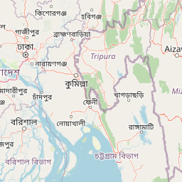
Map view of Nijhum Dweep National Park

Use this park location map to pinpoint Nijhum Dweep National Park in Bangladesh, understand its exact geographic position, and read its mapped placement within the surrounding landscape more clearly.

Pigeon | © OpenStreetMap contributors

Location context for Nijhum Dweep National Park

Chittagong DivisionNoakhali District
Park atlas

Trace the regional spread of deltaic protected areas, mangrove forests, and coastal wetlands for comparison

Discover Other Protected Areas Near Nijhum Dweep National Park and Its Deltaic Ecosystem
After exploring the unique mangrove forests and island geography of Nijhum Dweep National Park, delve into an atlas of other protected areas spanning Bangladesh's deltaic region and coastal wetlands. Compare diverse ecosystems and conservation landscapes, tracing their regional spread for richer geographic context and deeper protected-area discovery.
National parkChittagong District

Baroiyadhala National Park: A Vital Wildlife Corridor and Protected Forest Landscape in Bangladesh

Discover its terrain, mapped boundaries, and regional significance.

Baroiyadhala National Park, situated in Bangladesh's Chittagong District, stands as a critical national park dedicated to preserving forest ecosystems and functioning as an essential wildlife corridor. The park's undulating terrain and dense vegetation are vital for supporting threatened species and maintaining habitat connectivity. This page offers an atlas-style exploration of Baroiyadhala National Park, detailing its protected area status, geographic context within the Chittagong region, and its significance for conservation in South Asia, providing a rich understanding of its natural landscape.

Area
29.34 km²
Established
2010
IUCN
II
Climate
Tropical
National parkPatuakhali District

Kuakata National Park: Protected Landscape Identity and Geographic Atlas

Mapped boundaries and regional context within Patuakhali District.

Kuakata National Park is a significant protected area designated as a national park, offering valuable insights into the geography of Patuakhali District. This park detail page provides a structured exploration of its mapped boundaries and protected landscape characteristics, serving as a vital entry point for understanding its place within the larger atlas of global natural sites. Focus on its specific geographic setting and conservation status for detailed discovery.

Area
16.13 km²
Established
2010
IUCN
II
Relief
Lowland
National parkCox's Bazar District

Medhakachhapia National Park: Protected Mangrove Landscape and Geography in Cox's Bazar

Mapping the boundaries of a unique coastal Bangladesh National Park.

Medhakachhapia National Park is a distinct protected area in Cox's Bazar District, Bangladesh, renowned for its old-growth Rhizophora apiculata mangrove forest. Spanning approximately 396 hectares, it serves as a crucial habitat and represents a specific type of tropical coastal landscape. This park's designation as a national park highlights its conservation importance, particularly its role in protecting some of Bangladesh's most mature mangrove stands. Explore its geographic context and protected status for a deeper understanding of its natural landscape.

Area
3.959 km²
Established
2008
IUCN
IV
Relief
Lowland
National parkRangamati District

Kaptai National Park: Protected Landscape and Geographic Context in Rangamati District

Explore its mixed evergreen forest and lakeside terrain.

Kaptai National Park is a crucial protected area located in Bangladesh's Rangamati District, renowned for its mixed evergreen forests and unique position adjacent to Kaptai Lake. This detail page provides an atlas-oriented perspective on the park's geographic identity, mapped boundaries, and its role within the diverse Chittagong Hill Tracts region. Understand the terrain, from rolling hills to lakeside environments, and appreciate its conservation significance as a national park.

Area
54.64 km²
Established
1999
IUCN
II
Climate
Subtropical
National parkBangladesh

Himchari National Park: A Protected National Park within Bangladesh's Delta Geography

Mapped protected area and landscape context in South Asia.

Himchari National Park represents a vital protected natural area contributing to the rich geography of Bangladesh. As a national park, it offers users a focal point for understanding mapped landscapes and the distribution of conservation lands within the South Asian delta region. Exploring this entity provides insight into the country's protected areas and their unique environmental settings for structured atlas discovery.

Area
17.29 km²
Established
1980
IUCN
IV
Relief
Upland
National parkTripura

Clouded Leopard National Park: National Park Protected Area in Tripura's Forested Landscape

Mapped primate habitat and regional geography in Northeast India.

Clouded Leopard National Park serves as a critical protected area within Tripura, India, focusing on the conservation of its forest ecosystems and primate populations, including the Phayre's langur. As part of the larger Sepahijala Wildlife Sanctuary, its mapped boundaries contribute to the regional protected landscape. This national park offers valuable insight into the natural terrain and biodiversity specific to Northeast India, providing a unique geographic focus for atlas exploration.

Area
5.08 km²
Established
2007
IUCN
II
Climate
Tropical
National parkIndia

Phawngpui National Park: An Indian National Park's Protected Landscape and Geography

Explore its mapped boundaries and regional natural terrain.

Phawngpui National Park stands as a distinct protected area within India, contributing significantly to the nation's atlas of natural landscapes. Its designation as a national park underscores its importance for understanding regional geography and mapped terrain. This profile focuses on the park's specific protected-area identity and its role in the broader geographic context of India, offering clear insights for landscape and park map discovery.

Area
50 km²
Established
1992
IUCN
II
Visitors
469 annual
Watercolor painting showing mangrove trees, water channels, and hills in the background
National parkWest Bengal

Sundarbans National Park: UNESCO World Heritage Mangrove National Park in West Bengal

Explore its tidal geography and mapped protected boundaries.

Sundarbans National Park is a vital protected area on the Ganges Delta, recognized globally as the world's largest mangrove forest and a UNESCO World Heritage Site. Located in West Bengal, this national park features a unique estuarine geography characterized by intricate tidal channels and distributaries that define its landscape. Its protected boundaries safeguard a complex ecosystem, offering rich opportunities for atlas-driven exploration of its distinctive natural terrain and coastal wetland significance.

Area
1,330.1 km²
Established
1984
IUCN
II
Relief
Lowland

Common questions about visiting, size, designation, and location context for Nijhum Dweep National Park

Nijhum Dweep National Park FAQs for park facts, access, geography, and protected area context
Find quick answers about Nijhum Dweep National Park, including protected-area facts, park geography, trail and visitor context, and how the park fits into its surrounding country and regional landscape.
MoriAtlas Explorer

Continue Your Protected Areas Search Across the Global Atlas

Deepen your exploration by continuing the structured search for national parks and protected areas worldwide. Utilize the comprehensive filtering capabilities to compare different conservation landscapes and refine your understanding of global park geography. Discover more about the distribution and characteristics of protected natural areas.

Global natural geography