Mori Atlas logo
National parkNki National Park

Discover the mapped boundaries and geographic context of Nki National Park.

Nki National Park: A National Park Landscape in Cameroon's Protected Area Atlas

(Parc national de Nki)

Nki National Park stands as a significant protected landscape within Cameroon, representing a key national park entity for geographic discovery. This page provides detailed insights into its protected area identity and location within the broader atlas of natural landscapes. Users can explore the park's specific geographic context and understand its role as a designated national park within Central Africa's diverse terrain.

National ParkCongo BasinForest ElephantsGorillasBirdwatchingTropical Rainforest

Nki National Park

National park

Park overview

Structured park overview, official facts, and landscape profile for Nki National Park

Nki National Park park facts, protected area profile, and essential visitor context
Review the core facts for Nki National Park, including designation, size, terrain, visitor scale, habitats, and operating context in one park-focused overview.

About Nki National Park

Nki National Park represents one of Cameroon and Central Africa's most significant conservation achievements, protecting a substantial portion of the Congo Basin's rainforest heritage. The park's extreme remoteness has allowed it to retain much of its original character and ecological integrity, unlike many other forest protected areas in the region that have suffered from logging, agriculture, or other human pressures. The landscape is predominantly hilly, with elevation ranging from 350 to 650 meters, and the terrain remains largely unexplored in some areas. The park is bisected by the Dja River, which serves as both a vital water source and a transportation corridor for wildlife. The river also creates challenging conditions for poachers during certain seasons due to strong currents, though this seasonal protection is limited. Nki's ecosystem supports a remarkable diversity of habitats, from semi-evergreen forests with towering canopy trees to seasonally flooded riparian zones along the Dja. The park's position within the Sangha ecoregion places it at the heart of a transboundary conservation landscape that spans three nations, creating opportunities for collaborative wildlife management and habitat protection across international borders.

Quick facts and research context for Nki National Park

Nki National Park spans 3,093 km² in southeastern Cameroon, making it one of the country's largest protected areas. The park was officially established on October 17, 2005, following its designation as an Essential Protection Zone in 1995. Located at elevations between 350 and 650 meters above sea level, the park features hilly terrain within the Sangha ecoregion. The Dja River traverses the park, and Nki Falls provides a notable waterfall feature. The area experiences a tropical climate with average temperatures around 24°C and annual rainfall of approximately 1,500 mm. The surrounding region has a population density of only about five people per square kilometer, reflecting the extreme remoteness of the area. The park contains 73 known bais, which are forest clearings that serve as critical wildlife aggregation points.

Park context

Deeper park guide and search-rich context for Nki National Park

Nki National Park history, landscape, wildlife, and travel context
Explore Nki National Park through its history, landscape character, ecosystems, wildlife, conservation priorities, cultural context, and seasonal travel timing in a structured park guide built for atlas discovery and search intent.

Why Nki National Park stands out

Nki National Park is best known for its extraordinary elephant populations and pristine rainforest wilderness. The park hosts one of the highest densities of African forest elephants in Central Africa, with an estimated 3,000 individuals and a density of roughly 2.5 elephants per square kilometer when combined with neighboring Boumba Bek National Park. The park is also home to approximately 6,000 gorillas, making it a crucial stronghold for these endangered primates. Its 73 forest clearings, known as bais, support remarkable wildlife congregations, including the recently discovered Ikwa Bai, the largest in the region. The park's avifauna includes over 265 recorded bird species. The area is also significant for its population of Baka Pygmies, whose ancestral lands overlap with the park boundaries.

Nki National Park history and protected-area timeline

The conservation history of Nki National Park spans several decades and reflects the complex challenges of protecting Central Africa's forest wilderness while acknowledging the rights and livelihoods of local communities. The World Wildlife Fund began working on conservation in the region during the 1980s, with initial efforts focused on addressing the logging industry that had been active in the area. The former logging town of Ndongo, once home to approximately 300 residents with functioning roads and employment opportunities, became a symbol of this transition when logging companies withdrew in 1988 following pressure from conservation organizations. This departure left behind broken machinery and a damaged local economy, creating tensions between conservation goals and community needs. In 1995, Nki was designated as an Essential Protection Zone, granting it formal protected status for the first time. The park was officially established as a national park on October 17, 2005, when the Cameroonian government decreed the creation of both Nki and Boumba Bek National Parks. Throughout this period, Baka Pygmy communities have advocated for reduced park boundaries and greater usage rights, arguing that the protected area encroaches on their ancestral lands. The park is now part of the TRIDOM initiative, a tri-national conservation program coordinating forest management across Cameroon, Gabon, and the Central African Republic.

Nki National Park landscape and geographic character

The landscape of Nki National Park is characterized by gently rolling hills throughout much of its expanse, with elevations ranging from 350 to 650 meters above sea level. The terrain remains largely undeveloped and has never been completely explored, adding to the park's mystique as a wilderness area. The Dja River, one of the region's most significant waterways, traverses the park from south to north, providing a critical water source for both wildlife and the surrounding ecosystem. Nki Falls, a notable waterfall on the river, adds a striking natural feature to the landscape. The park contains 73 documented bais, which are natural forest clearings that provide open spaces within the otherwise dense rainforest. The largest of these, Ikwa Bai, was discovered in April 2006 and spans a slightly larger area than the previously record-holding Dzanga Sangha Bai in the Central African Republic. These clearings typically feature small creeks running through their centers, rocky and sandy substrates, and mineral pits that attract wildlife seeking essential nutrients. The forest surrounding these clearings is primarily semi-evergreen with an open canopy dominated by tall Triplochiton trees reaching 50 to 60 meters in height, interspersed with patches of closed evergreen forest.

Nki National Park ecosystems, habitats, and plant life

The ecological character of Nki National Park is defined by its position within the Sangha ecoregion, one of the most biodiverse forest regions in Central Africa. The park's primary forest type is semi-evergreen forest with an open canopy, where the towering Triplochiton tree dominates the landscape, reaching heights of 50 to 60 meters. This forest type is interspersed with larger patches of closed evergreen forest, creating a mosaic of habitats that supports diverse species assemblages. Along the Dja River and other watercourses, seasonally flooded Uapaca trees create distinctive riparian zones that experience periodic inundation. The park's network of 73 bais, or forest clearings, represents a unique habitat type that breaks the continuous forest cover and provides critical resources for wildlife. These clearings support concentrations of megafauna that would be difficult to observe in the dense forest and serve as natural mineral licks where elephants, gorillas, and other animals gather to feed on nutrient-rich soils. The combination of forest types, river systems, and clearings creates a complex ecological system that supports exceptional biodiversity.

Nki National Park wildlife and species highlights

Nki National Park supports an extraordinary concentration of wildlife, with particular significance for forest elephants and great apes. The park hosts approximately 3,000 African forest elephants, representing one of the highest population densities in Central Africa at roughly 2.5 individuals per square kilometer. This population has shown encouraging growth, rising from 1,547 individuals in 1998 to 3,000 by 2006. Gorillas are also abundant, with an estimated 6,000 adults residing within the park. The park supports diverse primate populations including the crested monkey, De Brazza monkey, and black colobus, with the latter two species reportedly found only east of the Dja River. Other notable mammals include sitatunga, various duikers, bushbucks, giant forest hogs, bush pigs, leopards, and bongos. The avifauna is equally impressive, with 265 bird species recorded, including the Dja River scrub warbler and several nightjar species. The discovery of Prigogine's nightjar in the park suggests the presence of species previously known only from the Democratic Republic of Congo. Crocodiles inhabit the river systems, and hundreds of fish species are found in the park's waters.

Nki National Park conservation status and protection priorities

Nki National Park represents a critical conservation priority within Central Africa's Congo Basin, protecting some of the region's most intact rainforest and the species that depend on it. The park's designation as an Essential Protection Zone in 1995 and its formal establishment as a national park in 2005 reflect Cameroon commitment to preserving this wilderness area. The forest elephant population, despite facing significant poaching pressure, has shown recovery from 1,547 individuals in 1998 to approximately 3,000 by 2006, demonstrating the potential effectiveness of protection measures. However, poaching remains the most significant threat to the park's wildlife, driven by economic pressures following Cameroon's depression in the 1980s. The removal of logging operations from the park represents a conservation success, as the infrastructure requirements for commercial logging would have fragmented the wilderness. The park's integration into the TRIDOM initiative creates a transboundary conservation framework spanning Cameroon, Gabon, and the Central African Republic, connecting Nki with Minkebe National Park, Boumba Bek National Park, Odzala National Park, and the Dja Wildlife Reserve. This tri-national approach aims to create coordinated land management plans and establish wildlife corridors across international borders.

Nki National Park cultural meaning and human context

The area surrounding Nki National Park is home to approximately 22,882 people, comprising both Bantu ethnic groups and Baka Pygmies, who are recognized as a minority in Cameroon's constitution. The Baka, along with other groups including the Djem, Bangando, Bakwele, and Zime tribes, have ancestral connections to the forest lands that now fall within the park boundaries. The relationship between conservation efforts and indigenous communities has been complex, with the establishment of the park creating tensions over land use and resource access. Prior to WWF intervention in the 1980s, the area supported logging operations that provided employment in towns like Ndongo. The departure of logging companies in 1988 had significant economic impacts on local communities, and some indigenous groups have opposed the park's boundaries, requesting reduced areas and greater usage rights. Conservation organizations have recognized the need to address community welfare alongside wildlife protection, acknowledging that poverty alleviation is essential for successful forest conservation.

Best time to visit Nki National Park

Nki National Park can be visited year-round, though the tropical climate creates distinct seasonal conditions that affect the visitor experience. The area experiences two rainy seasons, from September to November and from March to June, separated by two dry seasons from November to March and from July to August. During the dry seasons, wildlife viewing along the Dja River and at the forest clearings becomes more accessible as animals concentrate around remaining water sources. The period from November to March generally offers the most comfortable conditions for exploration, with lower humidity and reduced rainfall. However, visitors should note that the strong currents on the Dja River during the rainy seasons create natural barriers that have historically limited poaching activity in central areas of the park. The wetter periods, while presenting logistical challenges, offer the opportunity to experience the park's waterfalls and lush rainforest atmosphere at their peak. Due to the park's extreme remoteness, all visits require careful planning and coordination with park management authorities.

Park location guide

Geography guide, regional context, and park location map for Nki National Park

Nki National Park park geography, regions, and map view in Cameroon
Understand where Nki National Park sits in Cameroon through a broader geographic reading of the surrounding landscape, nearby location context, and its mapped position within the national park landscape.

How Nki National Park fits into Cameroon

Cameroon is a Central African country spanning coastal, highland, and forest regions. It has a population of nearly 31 million people who speak 250 native languages alongside English and French as official languages. The country gained independence from France in 1960 and unified with British Southern Cameroons in 1961.

Wider geography shaping Nki National Park in Cameroon

Cameroon is located in Central Africa, bordering Nigeria and Chad to the west and north, the Central African Republic to the east, and Equatorial Guinea, Gabon, and the Republic of the Congo to the south. The country has a coastline on the Bight of Biafra, part of the Gulf of Guinea. Terrain includes coastal plains, mountainous highlands (including Mount Cameroon), plateaus, and dense rainforest regions.

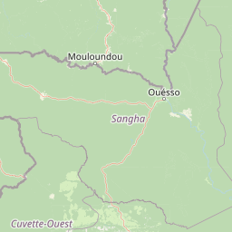
Map view of Nki National Park

Use this park location map to pinpoint Nki National Park in Cameroon, understand its exact geographic position, and read its mapped placement within the surrounding landscape more clearly.

Pigeon | © OpenStreetMap contributors

Location context for Nki National Park

East Province
Park atlas

Compare other protected areas within Cameroon's Congo Basin, tracing the mapped regional geography and vital conservation landscapes.

Explore Other National Parks and Protected Areas Near Nki National Park, Cameroon
Browse other national parks and protected areas near Nki National Park, encompassing vital rainforest ecosystems and conservation landscapes across Cameroon's Congo Basin. Compare their distinct protected geographies, trace the distribution of key wildlife habitats, and expand your understanding of Central African park interconnections.
National parkEast Province

Boumba Bek National Park: National Park with Protected Landscape Identity in East Province

Explore its geographic context and mapped protected boundaries.

Boumba Bek National Park is a key protected area within Cameroon's East Province, offering a dedicated focus for understanding national park landscapes. This resource facilitates discovery of its precise geographic footprint and its significance as a mapped protected land. Users can delve into its regional context and explore the atlas-level details defining its protected status and natural landscape character.

Area
2,382 km²
Established
2005
IUCN
II
Relief
Lowland
National park

Lobéké National Park National Park: A Protected Landscape within the Congo Basin

Explore its semi-evergreen forest, unique bais, and riverine ecosystems.

Lobéké National Park represents a core protected national park within the vast Congo Basin, renowned for its exceptionally high densities of African forest elephants and western lowland gorillas. Covering over 2,000 square kilometers of largely untouched semi-evergreen forest, the park features distinct ecosystems including mineral-rich bais clearings, saline swamp savannas, and diverse riverine habitats. As a crucial component of the Sangha Trinational protected area, Lobéké National Park offers a profound look into Central African wilderness and its unique natural geography.

Area
2,178 km²
Established
1999
IUCN
II
Relief
Lowland
National parkCuvette-Ouest Department

Odzala-Kokoua National Park National Park: Mapped Protected Landscape in Cuvette-Ouest

Explore its geographic boundaries and regional terrain.

Odzala-Kokoua National Park is a key national park entity, offering a distinct protected landscape within the Cuvette-Ouest Department. This page provides an atlas-style exploration of its mapped boundaries and geographic context. Delve into the specifics of this protected area to understand its contribution to the regional geography and natural landscape, facilitating structured discovery of its terrain.

Area
13,500 km²
Established
1935
IUCN
II
Visitors
50 annual
Watercolor painting showing rolling hills, green vegetation, and a pinkish river area
National parkCentral African Republic

Dzanga-Ndoki National Park National Park: Mapped Boundaries and Geographic Context in Central Africa

Explore protected landscape geography and park atlas details.

Gain a structured understanding of Dzanga-Ndoki National Park as a protected area in the Central African Republic. This page focuses on its precise geographic scope, mapped park boundaries, and its identity as a National Park. It serves as an entry point for exploring the park's landscape context and its place within the atlas of protected natural areas, offering factual details for geographic discovery.

Area
1,143.26 km²
Established
1990
IUCN
II
Relief
Lowland
National parkGabon

Minkébé National Park: Protected Area and Geographic Context in Gabon

Explore the mapped terrain and protected landscape of this national park.

Gain a structured understanding of Minkébé National Park, a designated national park situated in Gabon. This destination focuses on the park's protected landscape, its distinct mapped boundaries, and its contribution to the regional geography of Central Africa. Examine how its protected status shapes the natural terrain and offers a unique angle for geographic discovery.

Area
7,570 km²
Established
2002
IUCN
II
Relief
Upland
National parkCongo

Nouabalé-Ndoki National Park: Congo National Park & Protected Landscape Atlas

Explore protected area geography and mapped terrain.

Nouabalé-Ndoki National Park is a designated national park in Congo, offering rich opportunities for geographic discovery and atlas exploration. This page details the park's protected landscape, its mapped boundaries, and its significance within the regional geography of Congo. Users can investigate the park's natural terrain and its place within the broader atlas of protected areas.

Area
3,921.61 km²
Established
1993
IUCN
II
Relief
Lowland
National parkGabon

Ivindo National Park: A Protected Rainforest Landscape in Gabon

Explore its waterfalls, diverse ecosystems, and mapped geographic context.

Ivindo National Park represents a significant protected landscape within Gabon, spanning a vast area of intact tropical rainforest. Recognized as a UNESCO World Heritage Site, the park is defined by the Ivindo River and its dramatic waterfalls, including the famous Kongou and Mingouli Falls. Its geography includes mountainous terrain and vital riverine ecosystems, supporting critical populations of forest elephants and great apes. This page offers a gateway to understanding the park's protected status, its unique natural features, and its role in the broader geography of Central Africa.

Area
3,000 km²
Established
2002
IUCN
II
Relief
Mixed relief
National parkCongo

Ntokou-Pikounda National Park: Congo's Protected Landscape and Regional Geographic Atlas

Explore the mapped boundaries of this national park in Congo.

Ntokou-Pikounda National Park serves as a critical point of reference for understanding protected landscapes in Congo. As a national park, its geographic scope and mapped boundaries are essential for atlas-based discovery. This detailed entry facilitates an exploration of its protected terrain and regional context, highlighting its significance within the broader conservation geography.

Area
4,572 km²
Established
2012
IUCN
II
Relief
Lowland

Common questions about visiting, size, designation, and location context for Nki National Park

Nki National Park FAQs for park facts, access, geography, and protected area context
Find quick answers about Nki National Park, including protected-area facts, park geography, trail and visitor context, and how the park fits into its surrounding country and regional landscape.
MoriAtlas Explorer

Continue Your Protected Areas Search Across the Global Atlas

Deepen your exploration by continuing the structured search for national parks and protected areas worldwide. Utilize the comprehensive filtering capabilities to compare different conservation landscapes and refine your understanding of global park geography. Discover more about the distribution and characteristics of protected natural areas.

Global natural geography