
Mori Atlas logo
National parkNyungwe National Park

Discover the mapped boundaries and natural terrain of this East African protected area.

Nyungwe National Park: Rwanda's Protected National Park Landscape and Geography

Nyungwe National Park stands as a significant protected national park within Rwanda, offering a focal point for exploring the nation's unique geography and conservation landscapes. As a key protected area, its mapped boundaries define a region rich in natural terrain, contributing to the broader atlas of East African protected lands. Users can delve into the specific geographic context and landscape character of this national park, understanding its role within Rwanda's diverse natural environment for structured discovery.

rainforestmountain forestchimpanzeesAlbertine RiftEast AfricaRwanda

Nyungwe National Park

National park

Park overview

Structured park overview, official facts, and landscape profile for Nyungwe National Park

Nyungwe National Park park facts, protected area profile, and essential visitor context

Review the core facts for Nyungwe National Park, including designation, size, terrain, visitor scale, habitats, and operating context in one park-focused overview.
Protection and recognition

Analyzing official conservation frameworks and global designations within the Rwandan landscape

Nyungwe National Park Protection Status and UNESCO World Heritage Recognition

Documented records detail the formal protection status of Nyungwe National Park, highlighting its inclusion as a UNESCO World Heritage site. Atlas data compiles official designations and management frameworks to provide a clear geographic perspective on regional conservation.
Monthly climate preview

Long-term representative point measurements tracking monthly averages across the protected terrain

Nyungwe National Park Climate Normals, Annual Temperature and Precipitation Rhythm

Nyungwe National Park exhibits measured annual temperature ranges between seventeen and twenty degrees Celsius alongside monthly precipitation variations from less than one millimeter up to six millimeters daily. Analyzing the complete twelve-month record clarifies long-term baseline conditions and year-round environmental patterns across the protected landscape.
Annual mean19 °C
18 °C20 °C
Jan19°
Feb20°
Mar19°
Apr19°
May18°
Jun18°
Jul18°
Aug19°
Sep20°
Oct20°
Nov19°
Dec19°
Warmest month
September

20 °C

Coolest month
June

17.8 °C

Wettest month
November

6.6 mm/day

Driest month
July

0.8 mm/day

Park location guide

Geography guide, regional context, and park location map for Nyungwe National Park

Nyungwe National Park park geography, regions, and map view in Rwanda

Understand where Nyungwe National Park sits in Rwanda through a broader geographic reading of the surrounding landscape, nearby location context, and its mapped position within the national park landscape.

How Nyungwe National Park fits into Rwanda

Rwanda is a landlocked East African nation bordered by Uganda, Tanzania, Burundi, and the Democratic Republic of the Congo. The country features mountains in the west, savanna in the southeast, and several volcanoes in the northwest forming part of the Virunga chain. It has a tropical highland climate with two rainy and two dry seasons annually.

Wider geography shaping Nyungwe National Park in Rwanda

Rwanda lies in the Great Rift Valley of East Africa, bordered by Uganda to the north, Tanzania to the east, Burundi to the south, and the Democratic Republic of the Congo to the west. The western region features mountains and lakes, while the southeast consists of savanna. Several volcanoes forming part of the Virunga Mountains are located in the northwest.

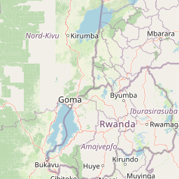
Map view of Nyungwe National Park

Use this park location map to pinpoint Nyungwe National Park in Rwanda, understand its exact geographic position, and read its mapped placement within the surrounding landscape more clearly.

Pigeon | © OpenStreetMap contributors
Park atlas

Trace the geographic spread of protected landscapes, comparing park features and conservation efforts across the Albertine Rift region.

Continue Your Park Discovery: Explore National Parks and Protected Areas Surrounding Nyungwe National Park

Expand your exploration beyond Nyungwe National Park to browse other national parks and protected areas in Rwanda and the broader East Africa region. Compare mapped park geography, trace regional conservation landscapes, and understand the spread of significant natural habitats, including those found within the Albertine Rift.
National parkRwanda
Mapped park locations coincide#1 closest

Nyungwe Forest National Park: Protected Landscape in Rwanda's Geography

National park mapping and regional context discovery.

Understand Nyungwe Forest National Park as a distinct protected landscape within the atlas of Rwanda. This page details its status as a national park, focusing on its geographic positioning and mapped protected boundaries. Explore the park's integral role in the regional geography of East Africa, providing a foundation for structured discovery of its natural terrain and conservation importance.

National parkBurundi
About 50 km away#2 closest

South

Kibira National Park: Burundi's Protected National Park Landscape and Geography

Mapped protected area within the Great Rift Valley region.

Kibira National Park represents a vital protected national park entity within Burundi's diverse geography. As part of the Great Rift Valley's expanse, its mapped boundaries and landscape identity offer a focal point for understanding regional protected areas. This park's presence in Burundi contributes essential data to a structured atlas of natural landscapes and conservation lands across East Africa.

Area
400 km²
IUCN
II
Relief
Mountain
Climate
Tropical
Watercolor illustration of a landscape with mountains, water bodies, and grassy fields
National parkDemocratic Republic of the Congo
About 60 km away#3 closest

West

Kahuzi-Biega National Park: Protected Volcanic and Rainforest Landscapes in the Congo

Geographic atlas of the Mitumba Mountains and lowland rainforest transition

Kahuzi-Biega National Park occupies a significant expanse in the eastern Democratic Republic of the Congo, connecting mountainous volcanic terrain with sprawling tropical lowland forests. The area supports an unparalleled diversity of vegetation, tracking from subalpine summits down to rare swamp and riparian habitats. This site acts as a key reference for understanding the ecological richness of the Albertine Rift and the broader Congo Basin landscape.

Area
6,000 km²
Established
1970
IUCN
II
Relief
Mixed relief
National parkSouth Kivu Province
About 62 km away#4 closest

West

Kahuzi-Biéga National Park: Protected Mountain and Rainforest Geography in South Kivu

Mapped terrain from volcanic summits to equatorial forest basins.

Kahuzi-Biéga National Park represents a significant protected area within the South Kivu Province. The geography features two distinct sectors connected by a narrow ecological corridor, encompassing everything from high-altitude subalpine heather zones to dense tropical lowland environments. This dataset provides a detailed look at the park boundaries, volcanic topography, and the regional landscape context that defines this essential habitat.

Area
6,000 km²
Established
1970
IUCN
II
Relief
Mixed relief
National parkWestern Province
About 83 km away#5 closest

North

Gishwati Forest National Park: Discover Rwanda's Protected Landscape Geography

Mapped protected area boundaries and regional natural landscape.

Gishwati Forest National Park offers a focused exploration of a significant protected natural landscape in Rwanda's Western Province. This resource provides detailed geographic context, highlighting the park's mapped boundaries and its role within the country's conservation areas. Understand its terrain and regional landscape importance through an atlas-centric view.

Area
32.02 km²
Established
2015
IUCN
IV
Relief
Mountain
National parkRwanda
About 83 km away#6 closest

North

Gishwati-Mukura National Park: Rwanda's Protected Montane Forest Landscape in the Albertine Rift

Explore its mapped boundaries and regional geography.

Gishwati-Mukura National Park, located in western Rwanda, is a vital protected area renowned for its montane forest ecosystems. This national park occupies mountainous terrain characteristic of the Albertine Rift, contributing significantly to watershed protection and regional biodiversity. Users can explore its specific geographic context, mapped landscape features, and its role within Rwanda's broader conservation atlas.

Area
32.02 km²
Established
2015
IUCN
II
Relief
Highland
National parkBurundi
About 84 km away#7 closest

South

Rusizi National Park: National Park in Burundi's Geographic Landscape Context

Explore mapped protected area boundaries and regional geography.

Rusizi National Park stands as a significant protected area within Burundi, contributing to the nation's conservation atlas. This national park offers a distinct geographic profile, showcasing its specific landscape and terrain features within the East African context. Users can delve into the mapped boundaries of Rusizi National Park to understand its protected status and its role in the regional geography, facilitating detailed geographic discovery.

Area
90 km²
Established
1980
IUCN
II
Climate
Tropical
Watercolor illustration of rolling hills, mountains, and a river or lake
National parkDemocratic Republic of the Congo
About 95 km away#8 closest

North

Virunga National Park: Democratic Republic of the Congo's Premier Protected Landscape

Mapped boundaries and diverse Albertine Rift endemic geography.

Virunga National Park represents a pivotal protected area within the Democratic Republic of the Congo, characterized by an exceptional range of geographic features and vital ecosystems. Its protected landscape includes active volcanoes like Nyiragongo with its lava lake, the towering Rwenzori Mountains, and diverse lowland savannas. This atlas-focused entry highlights the park's unique position in the Albertine Rift, crucial for numerous endemic species and offering significant insight into regional geography and protected land context.

Area
7,800 km²
Established
1925
IUCN
II
Relief
Mountain

Common questions about visiting, size, designation, and location context for Nyungwe National Park

Nyungwe National Park FAQs for park facts, access, geography, and protected area context

Find quick answers about Nyungwe National Park, including protected-area facts, park geography, trail and visitor context, and how the park fits into its surrounding country and regional landscape.
MoriAtlas Explorer

Continue Your Protected Areas Search Across the Global Atlas

Deepen your exploration by continuing the structured search for national parks and protected areas worldwide. Utilize the comprehensive filtering capabilities to compare different conservation landscapes and refine your understanding of global park geography. Discover more about the distribution and characteristics of protected natural areas.

Global natural geography

