Mori Atlas logo
National parkOlympic National Park

Understand the mapped boundaries and regional terrain of this significant protected area.

Olympic National Park National Park: Its Geographic Identity and Protected Landscape in Washington

Olympic National Park in Washington represents a vital protected landscape within the United States, offering a unique opportunity for geographic exploration. This page delves into the park's specific identity as a national park, detailing its mapped boundaries and the regional context it occupies. Users can discover how its protected lands contribute to the broader geographic tapestry of Washington, providing a foundation for understanding its natural terrain and landscape character through an atlas-focused lens.

Temperate RainforestGlacial MountainsPacific CoastlineOld-Growth ForestWilderness AreaWorld Heritage Site

Olympic National Park

National park

Park overview

Structured park overview, official facts, and landscape profile for Olympic National Park

Olympic National Park park facts, protected area profile, and essential visitor context

Review the core facts for Olympic National Park, including designation, size, terrain, visitor scale, habitats, and operating context in one park-focused overview.

About Olympic National Park

Olympic National Park stands as one of the most ecologically diverse protected areas in the United States, preserving a compact yet extraordinarily varied landscape within a single management boundary. The Olympic Peninsula, a roughly circular landmass surrounded by the Pacific Ocean, Juan de Fuca Strait, and the waters of Puget Sound, supports four dramatically different environmental zones within its mountainous core. The Pacific coastline stretches for 60 miles, offering remote sandy beaches backed by forest and punctuated by dramatic sea stacks and tide pools. Rising behind the coast, the Olympic Mountains contain ancient glaciers carved into their peaks and ridges, the product of the range's position capturing moisture-laden Pacific storms. On the western slopes, the famous temperate rainforests of the Hoh and Quinault drainages receive more than 12 feet of annual precipitation, creating forests where huge western redcedar and Sitka spruce support epiphytic mosses and ferns in seemingly endless green layers. The eastern slopes lie in a rainshadow, supporting drier forest types and opening into subalpine meadows that burst with wildflowers in summer. This ecological variety exists because the mountains effectively separate the peninsula from surrounding landmasses, allowing unique species to evolve in isolation while creating the dramatic environmental gradients that define the park's character.

Quick facts and research context for Olympic National Park

Olympic National Park occupies the entire Olympic Peninsula in western Washington State, spanning four counties and protecting four distinct landscape regions. The park contains the Olympic Mountains, a range shaped by tectonic forces and glacial activity, with Mount Olympus rising to 7,965 feet as the highest peak. The western slopes receive extraordinary precipitation, with some areas recording over 12 feet annually, supporting the contiguous United States' most extensive temperate rainforests. The park holds approximately 366,000 acres of old-growth forests and maintains 60 miles of Pacific coastline featuring remote beaches and sea stacks. Nearly 95 percent of the park is designated wilderness, named the Daniel J. Evans Wilderness since 2017.

Protection and recognition

Documented conservation frameworks, biosphere reserve status, and global heritage classifications

Olympic National Park Protection Status and UNESCO Designations

Map the documented protection status, management scope, and conservation boundaries of Olympic National Park within the wider Pacific Northwest landscape. Verified records trace its designation history since 1976, outlining its dual recognition as a UNESCO World Heritage site and a Biosphere Reserve.

International recognition

Protection details

Protection scope
Mixed
Designated year
1976
Core area
3,509.88 km²
Buffer area
3,699.39 km²
Park context

Deeper park guide and search-rich context for Olympic National Park

Olympic National Park history, landscape, wildlife, and travel context

Explore Olympic National Park through its history, landscape character, ecosystems, wildlife, conservation priorities, cultural context, and seasonal travel timing in a structured park guide built for atlas discovery and search intent.

Why Olympic National Park stands out

Olympic National Park is best known for its remarkable temperate rainforests, particularly the Hoh and Quinault Rainforests, where moss-draped Sitka spruce and western hemlock create ethereal forest scenes unlike anything else in the continental United States. The park's glacier-capped Olympic Mountains contain the largest concentration of glaciers in the contiguous United States outside the North Cascades, with Mount Olympus holding the greatest glaciation of any non-volcanic peak in the lower 48. The Pacific coastline offers remote, rugged beach experiences with sea stacks, tide pools, and unbroken wilderness stretches. The park also protects critical habitat for Roosevelt elk, the largest elk subspecies in North America, and serves as a refuge for species found nowhere else on the planet.

Olympic National Park history and protected-area timeline

The protection of Olympic's wild lands unfolded over decades of political effort and evolving conservation philosophy. Long before European settlement, the Olympic Peninsula supported Native American communities including the Hoh and Quileute peoples, who utilized the coast, rivers, and mountain meadows for fishing, hunting, and gathering. The formal campaign to protect the Olympic Peninsula began with exploratory expeditions in the 1890s by Lieutenant Joseph P. O'Neil and Judge James Wickersham, whose combined political efforts led President Grover Cleveland to create the Olympic Forest Reserve in 1897. This reserve became Olympic National Forest in 1907, but it offered limited protection against logging interests. In 1909, President Theodore Roosevelt established Mount Olympus National Monument primarily to protect the subalpine calving grounds of Roosevelt elk herds. Pressure for full national park status grew through the 1920s and 1930s as clear-cutting revealed the ecological and scenic value of the peninsula's forests. On June 29, 1938, President Franklin D. Roosevelt signed legislation creating Olympic National Park, which the Civilian Conservation Corps then developed with infrastructure including the park headquarters, now on the National Register of Historic Places. The park expanded in 1953 to include the Pacific coastline between the Queets and Hoh rivers. In 1988, Congress designated 95 percent of the park as the Olympic Wilderness, later renamed the Daniel J. Evans Wilderness in 2017 to honor the former Washington governor and senator who co-sponsored the wilderness legislation.

Olympic National Park landscape and geographic character

The Olympic Peninsula's landscape reflects the powerful geological forces that created and continue to shape this mountainous promontory. The Olympic Mountains form a circular range rising from the peninsula's core, their peaks and ridges carved by Pleistocene glaciers into dramatic cirques, arêtes, and U-shaped valleys. Mount Olympus, at 7,965 feet, dominates the western Olympic Mountains and supports the largest glacier system of any non-volcanic peak in the contiguous United States. The mountains have a complex geological character, formed as an accretionary wedge where the Juan de Fuca Plate subducts beneath the North American continent, creating a curious mélange of basaltic and oceanic sedimentary rock. The coastal region presents a fundamentally different character, with 60 miles of sandy beach interrupted by rocky headlands, sea stacks, and tide pools. The Ozette Loop section offers access to one of the most remote coastal areas, where a boardwalk path traverses coastal cedar swamp before reaching wild beaches. The landscape also features distinctive turbidite formations and petroleum-scented mélanges that locals call smell rocks, geological signatures of the deep processes that built this land.

Olympic National Park ecosystems, habitats, and plant life

The ecological character of Olympic National Park is defined by extraordinary environmental gradients created by the interaction of moisture-laden Pacific storms with the Olympic Mountains. The western slopes intercept moisture-bearing weather systems, creating conditions that support the most extensive temperate rainforests in the continental United States. The Hoh and Quinault Rainforests exemplify this ecosystem, where annual precipitation exceeding 12 feet supports massive conifers including Sitka spruce, western hemlock, coast Douglas-fir, and western redcedar. These forests develop complex vertical structure, with epiphytic mosses and ferns coating every surface and creating the layered, otherworldly atmosphere that defines these places. The eastern slopes lie in the rainshadow of the mountains, receiving roughly 17 inches of annual precipitation in some areas, supporting drier forest types with smaller trees and less dense undergrowth. Above the forest line, subalpine meadows and wildflower gardens occupy valley floors and ridges, supporting species adapted to harsh alpine conditions. The park's isolation on a peninsula separated from other mountain ranges has allowed numerous endemic species to evolve, including the Olympic marmot, Piper's bellflower, and Flett's violet.

Olympic National Park wildlife and species highlights

Olympic National Park provides critical habitat for a remarkable assembly of wildlife species, some found nowhere else on Earth. The park's flagship large mammal is the Roosevelt elk, the largest subspecies of elk in North America, which the original park designation specifically sought to protect as a keystone species of the peninsula's ecosystems. Black-tailed deer are abundant throughout the park, serving as prey for the park's healthy cougar population estimated at approximately 150 individuals. Black bears are also plentiful, roaming the forests in search of berries, nuts, and other food sources. The park supports notable bird diversity, with species like the northern spotted owl inhabiting old-growth forests and bald eagles soaring along the coast. Mountain goats, though introduced accidentally in the 1920s, have established populations that have impacted native vegetation, prompting management efforts by the National Park Service. Marine mammals including whales, dolphins, sea lions, seals, and sea otters inhabit offshore waters. The streams support salmon runs, though dam removal on the Elwha River beginning in 2012 has restored access to historical spawning habitat for Pacific salmon and steelhead.

Olympic National Park conservation status and protection priorities

Olympic National Park represents one of the most significant conservation achievements in American protected area history, preserving ecological systems of global importance within a single national park boundary. The park's designation as a UNESCO World Heritage Site in 1981 recognized its outstanding universal value as a landscape containing remarkable ecological processes and habitats. Its earlier designation as an International Biosphere Reserve in 1976 acknowledged its role as a living laboratory for understanding temperate forest ecosystems. The park contains approximately 366,000 acres of old-growth forests, representing substantial remnants of the primeval forest that once covered the Pacific Northwest. The 1988 designation of 877,000 acres as wilderness, now called the Daniel J. Evans Wilderness, provides the highest level of federal protection for the vast majority of the park. The Elwha Ecosystem Restoration Project, the second-largest ecosystem restoration in National Park Service history, removed two dams beginning in 2012 to restore anadromous fish access to 65 miles of historical habitat. The park's isolation and variety of habitats have created conditions favoring endemism, with numerous species found nowhere else, reinforcing its importance as a biological reserve for understanding evolution and ecosystem dynamics.

Olympic National Park cultural meaning and human context

The human history of the Olympic Peninsula extends thousands of years, with indigenous peoples maintaining continuous presence long before European explorers arrived. The Hoh people inhabited the Hoh River valley while the Quileute made their home at La Push near the mouth of the Quileute River, both communities maintaining relationships with the coastal and forest environments that defined their cultural practices. Recent archaeological research has revealed more extensive use of subalpine meadows by indigenous peoples than previously understood, challenging earlier assumptions about the limited human footprint in Olympic mountains. European settlement brought timber extraction to the peninsula in the late 19th and early 20th centuries, generating the public pressure that eventually led to protected status for the region. The park's naming reflects the Olympic Mountains, which were named for their perceived resemblance to Mount Olympus in Greece, though the mountains themselves had no connection to Greek mythology. Place names throughout the park, like Sol Duc meaning sparkling waters in the Quileute language, preserve traces of indigenous heritage within the landscape.

Top sights and standout views in Olympic National Park

Olympic National Park offers visitors extraordinary diversity within a single destination, with the Hoh Rainforest presenting perhaps the most iconic experience, where cathedral-like aisles of moss-draped trees create an almost prehistoric atmosphere. Hurricane Ridge provides sweeping panoramic views of the Olympic Mountains and opportunities for winter sports, though the visitor center that burned in 2023 is slated for replacement. The Pacific coastline presents a distinctive backcountry experience, allowing multi-day beach hikes past sea stacks and through tidepool-rich intertidal zones. Lake Crescent, a glacially carved lake of extraordinary depth, offers boating and fishing in a dramatically beautiful setting. The Ozette Loop provides access to remote coastal wilderness via a boardwalk-enhanced route through ancient cedar swamp. The Elwha River restoration has opened former reservoir beds to restoration, creating new habitat for returning salmon runs.

Best time to visit Olympic National Park

Olympic National Park can be visited year-round, though the character of the experience changes dramatically with the seasons. Summer and early fall typically offer the most reliable conditions for backcountry travel and beach visits, with July, August, and September frequently delivering extended dry periods that allow access to rain forest trails without the constant drizzle typical of other months. The high country and subalpine meadows are most accessible from July through September, when snow has melted from trails and wildflowers paint the meadows in vivid colors. Winter transforms the park, particularly at Hurricane Ridge, which offers downhill skiing and snowboarding opportunities when weather permits access on Friday through Sunday. The rain forests are uniquely atmospheric in the cooler months, with the mosses and ferns maintaining their green intensity while fewer visitors share the trails. Coastal visits are possible year-round, though winter storms create dramatic wave action and visitors must be aware of tidal conditions that can block beach passages. The park's popularity means that overnight permits for backcountry routes like the Ozette Loop should be secured well in advance during summer months.
Monthly climate preview

Analyze long term temperature patterns and monthly precipitation averages based on historical data.

Olympic National Park Climate Normals and Average Weather by Month

Long term climatology at the representative elevation of 663 meters shows a distinct rhythm of wet, cold periods alongside drier, warmer conditions during the mid year months. Accessing the complete twelve month profile allows for a detailed comparison of average temperature shifts and daily precipitation trends.
Annual mean7 °C
2 °C14 °C
Jan
Feb
Mar
Apr
May
Jun11°
Jul14°
Aug14°
Sep12°
Oct
Nov
Dec
Warmest month
August

14.5 °C

Coolest month
December

1.6 °C

Wettest month
November

9.7 mm/day

Driest month
July

1.2 mm/day

Park location guide

Geography guide, regional context, and park location map for Olympic National Park

Olympic National Park park geography, regions, and map view in United States of America

Understand where Olympic National Park sits in United States of America through a broader geographic reading of the surrounding landscape, nearby location context, and its mapped position within the national park landscape.

How Olympic National Park fits into United States of America

The United States of America is a federal presidential republic and one of the world's largest countries by area and population. It consists of 50 states across a vast territory spanning multiple time zones, with its capital in Washington, D.C. and largest city in New York City. The nation has a diverse economy, influential political system, and significant cultural and military presence globally.

Wider geography shaping Olympic National Park in United States of America

The United States occupies a vast territory in North America, bordered by Canada to the north and Mexico to the south. The 48 contiguous states stretch from the Atlantic to the Pacific Ocean, while Alaska occupies the northwestern region and Hawaii is an archipelago in the Pacific. The country encompasses diverse terrain including the Rocky Mountains, Appalachian Mountains, Great Plains, and extensive river systems.

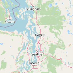
Map view of Olympic National Park

Use this park location map to pinpoint Olympic National Park in United States of America, understand its exact geographic position, and read its mapped placement within the surrounding landscape more clearly.

Pigeon | © OpenStreetMap contributors

Location context for Olympic National Park

Washington
Natural feature types

Continue Exploring Natural Features of Olympic National Park

Deepen your understanding of the geological and ecological makeup of Olympic National Park by browsing its mapped natural features. This MoriAtlas collection offers a structured approach to identifying the peaks, forests, and coastal landmarks that characterize this unique region.
Recorded earthquake history

Explore the Historical Earthquake Record Catalogue for Olympic National Park

Review documented seismic history for the Olympic National Park region through this structured catalogue of USGS event records. MoriAtlas provides a clear interface to sort and compare historical earthquake occurrences by magnitude and location to better understand recorded regional seismic patterns.

Olympic National Park Earthquake Records

Catalogued events

172 events

Strongest magnitude

Magnitude 5.8

Most recent event

Aug 19, 2025

This history includes earthquakes recorded inside the park or within 50 km of its borders

Park atlas

Trace the regional geography, comparing diverse protected landscapes across the Pacific Northwest.

Explore Nearby National Parks and Protected Areas Around Olympic National Park

Discover additional national parks and protected areas geographically connected to Olympic National Park across the broader Pacific Northwest region. Compare diverse ecosystems, mapped terrain, and conservation landscapes, tracing how protected areas like Olympic fit into the wider regional context.
Wildlife reserveWashington
Park boundaries overlap#1 closest

South

Mount Skokomish Wilderness: Ridge Systems and Alpine Geography in Washington State

Exploration of a protected Olympic Peninsula mountain landscape.

Mount Skokomish Wilderness protects a dramatic stretch of the eastern Olympic Mountains defined by steep ridges and glacial basins. The area serves as a critical headwaters region and offers a dense display of peaks and old-growth forest transitions across its varied elevation profile, providing essential landscape context for the region.

Area
53.79 km²
Established
1984
IUCN
Ib
Relief
Mountain
Marine protected areaWashington
Park boundaries overlap#2 closest

West

Olympic Coast National Marine Sanctuary: Mapping the Washington Outer Coast Marine Protected Area

Pacific Ocean canyons, shelf ecosystems, and coastal wilderness

Defined by its proximity to the Olympic Peninsula, this marine protected area spans a rugged stretch of the Pacific Ocean. The sanctuary encompasses significant seafloor features including the Nitinat and Quinault canyons, alongside dynamic upwelling zones that support diverse marine life and complex tidal habitats.

Area
8,260 km²
Established
1994
IUCN
IV
Climate
Temperate
Protected landscapeWashington
Park boundaries overlap#3 closest

Southeast

Olympic National Forest: Atlas and Geographic Overview of Washington Protected Lands

Temperate rainforests, alpine ridges, and fjord shorelines

Olympic National Forest defines the outer reaches of the Olympic Mountains, featuring a massive expanse of old-growth conifers and high-precipitation temperate rainforests. This protected area connects diverse ecosystems ranging from the brackish waters of Hood Canal to rugged, snow-dusted subalpine ridges. Our detailed geographic mapping highlights the forest's role as a vital buffer and wilderness corridor within the broader Pacific Northwest landscape.

Area
2,541.89 km²
Established
1897
Relief
Mountain
Climate
Temperate
Nature reserveBritish Columbia
About 23 km away#4 closest

North

Race Rocks Ecological Reserve: Protected Marine Landscape and Island Geography

Nature reserve in the Strait of Juan de Fuca, British Columbia

Race Rocks Ecological Reserve is a geographically distinct protected area consisting of low-lying rocky islets and surrounding high-current marine waters. Located in the Strait of Juan de Fuca, the reserve is recognized for its intense tidal mixing, which supports productive food webs and diverse marine mammals. This site provides a vital window into the ecological dynamics of the Pacific coast through its role as a dedicated research and conservation zone.

Area
2.27 km²
Established
1980
IUCN
Ia
Relief
Lowland
National parkBritish Columbia
32 km away#5 closest

Northwest

Pacific Rim National Park Reserve: National Park Protected Landscape & Map Atlas

Mapped boundaries and regional geographic context in British Columbia.

Pacific Rim National Park Reserve stands as a distinct protected natural landscape, serving as a critical component of Canada's national park inventory. This page facilitates an atlas-style exploration of its mapped boundaries and its position within the broader geography of British Columbia. Understanding the park's protected status and its integration with the surrounding natural terrain offers valuable insight into conservation landscapes.

Area
511 km²
Established
1970
IUCN
VI
Visitors
1.2M annual
National parkBritish Columbia
52 km away#6 closest

North

Gulf Islands National Park Reserve: British Columbia National Park Protected Area

Mapped boundaries and regional geographic context.

Delve into the protected landscape of Gulf Islands National Park Reserve, a significant national park located in British Columbia. This entry provides detailed insights into its mapped boundaries, regional geographic setting, and its identity as a protected area. Understand the park's place within the natural terrain and atlas of Canada, offering a clear geographic overview for focused discovery and landscape context.

Area
36 km²
Established
2003
IUCN
VI
Visitors
28.4K annual
Marine protected areaUnited States of America
About 78 km away#7 closest

Northeast

Padilla Bay National Estuarine Research Reserve: Coastal Protected Area Geography

A significant tidal estuary and marine protected landscape in Washington

This marine protected area encompasses large, shallow tidal mudflats and salt marshes within the Salish Sea. It serves as a essential hub for ecological research and conservation, framing a hybrid environment where historical diked farmlands meet protected coastal terrain. The reserve offers deep insight into the regional geography of Washington, detailing how tidal processes and human history have shaped this productive Pacific Northwest estuarine landscape.

Area
32 km²
Established
1980
Relief
Lowland
Access
Easy access
Protected landscapeWashington
99 km away#8 closest

East

Mount Baker, Snoqualmie National Forest: Mapped Geography and Protected Landscape Analysis

Exploratory atlas of Washington's primary Cascade Range wilderness

Delve into the structural geography of Mount Baker, Snoqualmie National Forest. This protected area corridor serves as a major ecological transition zone between the Puget Sound lowlands and the interior Cascades, characterized by extensive glaciers, wild river systems, and iconic stratovolcanoes that define the regional landscape of Washington state.

Area
6,978 km²
Established
1974
Relief
Mountain
Climate
Alpine

Common questions about visiting, size, designation, and location context for Olympic National Park

Olympic National Park FAQs for park facts, access, geography, and protected area context

Find quick answers about Olympic National Park, including protected-area facts, park geography, trail and visitor context, and how the park fits into its surrounding country and regional landscape.
MoriAtlas Explorer

Continue Your Protected Areas Search Across the Global Atlas

Deepen your exploration by continuing the structured search for national parks and protected areas worldwide. Utilize the comprehensive filtering capabilities to compare different conservation landscapes and refine your understanding of global park geography. Discover more about the distribution and characteristics of protected natural areas.

Global natural geography