
Mori Atlas logo
Nature reserveOstoja Augustowska

A comprehensive atlas exploration of boreal woodlands, peatland systems, and interconnected riverine wilderness

Ostoja Augustowska: Mapping the Protected Landscapes and Primeval Forest Geography of Northeastern Poland

Ostoja Augustowska represents a sprawling, ecologically intact expanse of coniferous forest and wetland mosaic in northeastern Poland. This protected landscape encompasses a diverse terrain of raised bogs, transitional mires, and dystrophic lakes along the Augustów Plain. By analyzing its mapped boundaries and geographic corridors, researchers and enthusiasts gain a deeper understanding of one of Central Europe's most significant wilderness refuges for large mammals and rare boreal flora.

Natura 2000lowland forestPuszcza Augustowskaconiferous forestpeatlandsraised bogs
A flat-style digital illustration showing a mountain valley viewed through a frame of tall trees in the foreground, with a winding river and a small waterfall on a rocky cliff in the distance under a soft, light-filled sky.

Ostoja Augustowska

Nature reserve

Park overview

Structured park overview, official facts, and landscape profile for Ostoja Augustowska

Ostoja Augustowska park facts, protected area profile, and essential visitor context

Review the core facts for Ostoja Augustowska, including designation, size, terrain, visitor scale, habitats, and operating context in one park-focused overview.

About Ostoja Augustowska

Ostoja Augustowska is one of the most extensive protected forest areas in Poland, designated as a Natura 2000 Site of Community Importance and forming a core component of the broader Augustów Primeval Forest landscape. Stretching roughly 50 kilometers across the northern reaches of Podlaskie Voivodeship, it covers nearly the entire Augustów Plain and reaches into the neighboring physiographic regions, including the eastern Suwałki Lake District to the north and the edge of the Biebrza Basin to the south.

From an ecological perspective, the site is characterized by an exceptional continuity of forest cover. Pine-dominated boreal fresh coniferous forests prevail across much of the southern part of the area, while spruce forests occupy the wetter habitats of the northern sections. Some older stands include 180-year-old pines and spruces reaching heights of up to 40 meters, reflecting pockets of near-natural forest structure. The forest mosaic is enriched by boggy alder woods, fragments of oak-lime-hornbeam forest, wet meadows, and pastures, while the northwestern portion is dominated by an extensive open peatland complex along the Rospuda river.

The diversity of wetland habitats is one of the site's defining features. Numerous dystrophic lakes are embedded within raised bog and transitional mire systems, and alkaline fens add further ecological richness. Eleven natural and semi-natural habitat types protected under the EU Habitats Directive have been documented here. The combination of forests, mires, and lakes makes Ostoja Augustowska a critical stronghold for threatened species and a key ecological corridor linking Central European forests with the larger woodland systems of Eastern Europe.

Beyond its ecological significance, Ostoja Augustowska is also highly relevant for nature-based tourism, low-impact recreation, and landscape preservation. Its proximity to Wigry National Park to the north and the Biebrza National Park to the south positions it within a network of major Polish protected areas, enhancing the regional value of northeastern Poland as a destination for wildlife observation, hiking, and exploration of relatively undisturbed European lowland wilderness.

Quick facts and research context for Ostoja Augustowska

Ostoja Augustowska is a Natura 2000 Site of Community Importance (code PLH200005) covering about 107,068 hectares in Podlaskie Voivodeship, Poland. It lies within the Augustów Plain and the edge of the Biebrza Basin, adjacent to the Polish-Lithuanian and Polish-Belarusian borders. Established in 2009 by the European Commission, the area encompasses approximately 50 kilometers of continuous forested landscape and overlaps substantially with the Puszcza Augustowska forest complex and its associated bird protection area. Thirteen nature reserves lie within its boundaries, and supervised protection is administered by the Regional Director for Environmental Protection in Białystok.

Protection and recognition

Documented terrestrial protection scope and international recognition records

Ostoja Augustowska Protection Status and Natura 2000 Recognition Data

Ostoja Augustowska maintains a documented terrestrial protection scope backed by official Natura 2000 recognition records. Structured conservation data details the established designation framework for this protected area.

International recognition

Protection details

Protection scope
Terrestrial
Transboundary protection
No
Park context

Deeper park guide and search-rich context for Ostoja Augustowska

Ostoja Augustowska history, landscape, wildlife, and travel context

Explore Ostoja Augustowska through its history, landscape character, ecosystems, wildlife, conservation priorities, cultural context, and seasonal travel timing in a structured park guide built for atlas discovery and search intent.

Why Ostoja Augustowska stands out

Ostoja Augustowska is best known for being one of the largest and most intact lowland forest complexes in Central Europe, formed by the Augustów Primeval Forest and its surrounding peatlands. It stands out for its vast pine and spruce boreal-type woodlands, abundant dystrophic lakes surrounded by bogs, and extensive raised bog and transitional mire systems along the Rospuda valley. Combined with its role as a corridor for large forest mammals and a refuge for rare orchid species and other threatened plants, the site represents a defining example of northeastern Poland's wilderness character within the EU Natura 2000 network.
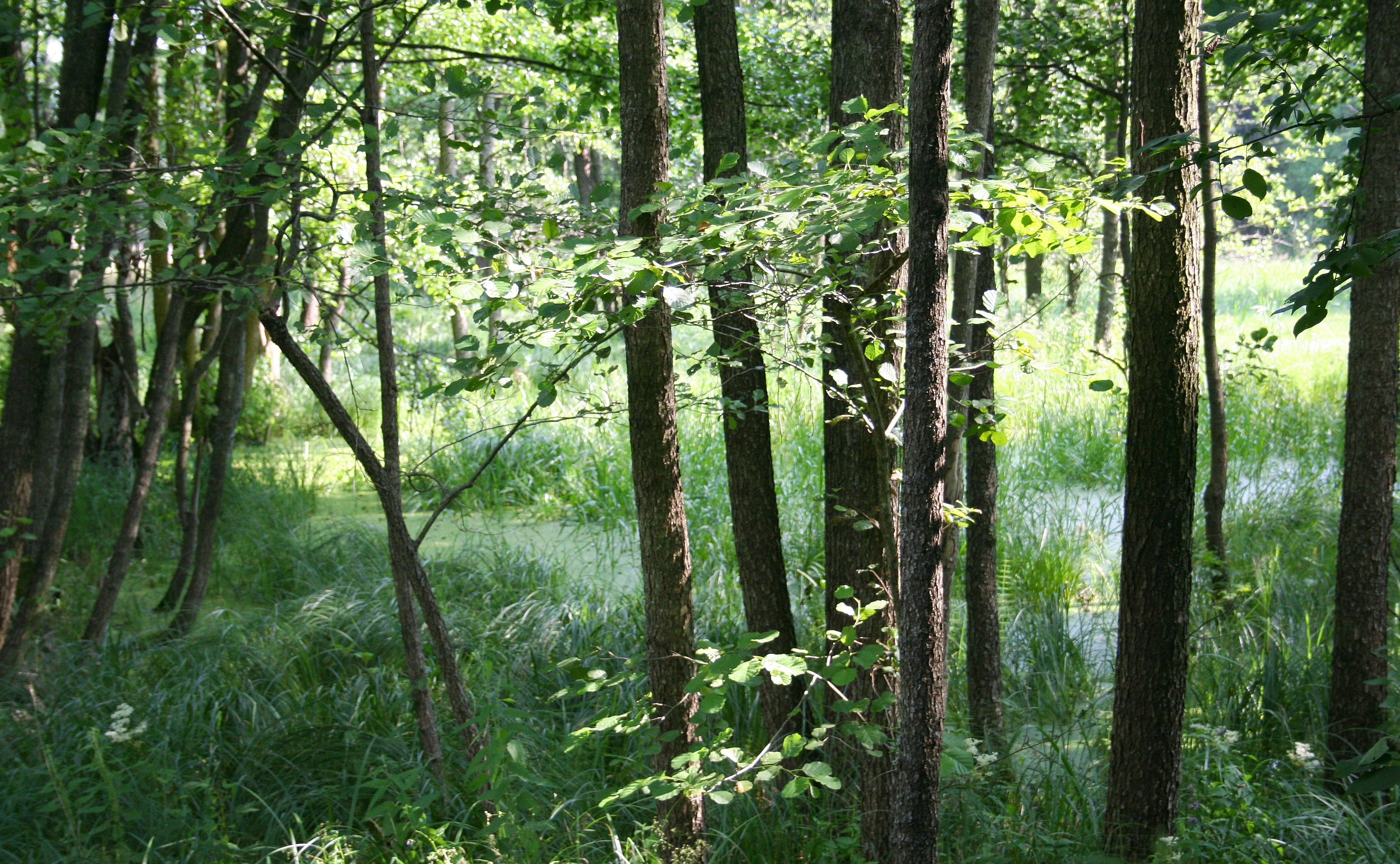
A dense forest scene with thin tree trunks and lush green undergrowth near a swampy, marshy area.
A forest community near the Rospuda River within Ostoja Augustowska.

Ostoja Augustowska history and protected-area timeline

Ostoja Augustowska was formally designated as a Site of Community Importance in 2009 by the European Commission, as part of the Natura 2000 ecological network designed to protect natural habitats and species of EU-wide importance. The designation followed expanding recognition during the early 2000s of the Augustów Primeval Forest as one of the most significant lowland forest complexes remaining in Central Europe, particularly important for ecological connectivity between Central and Eastern European woodland systems.

Earlier national-level protections had already been in place across parts of the area through the establishment of multiple nature reserves and the broader Obszar Chronionego Krajobrazu Puszcza i Jeziora Augustowskie, a Protected Landscape Area covering nearly 60 percent of the site. These layered protections created a foundation on which the European-scale Natura 2000 designation was built, integrating the region's existing reserve network into the EU-wide conservation framework. The site also substantially overlaps with the Puszcza Augustowska Special Protection Area (PLB200002), reinforcing its status under the Birds Directive.

Ostoja Augustowska landscape and geographic character

The landscape of Ostoja Augustowska is defined above all by vast, continuous forest cover set within a glacial lowland setting shaped by moraines, outwash plains, and post-glacial lake basins. The terrain belongs primarily to the Augustów Plain, with northern extensions into the Suwałki Lake District and southern edges reaching toward the Biebrza Basin. Altitude differences are modest, but the patterning of forests, peatlands, lakes, and river valleys creates a strongly varied scenery.

Open mires and peatland complexes occupy the northwestern part of the site, particularly along the Rospuda river, where a near treeless landscape of raised bogs and transitional mires dominates. Across the rest of the area, dense coniferous woodlands dominate the horizon, broken only by occasional clearings, meadow complexes, and small lake depressions. Dystrophic lakes dot the forested interior, usually ringed by Sphagnum bogs and alder swamp.

The result is a mosaic of near-natural forest, wetland, and open mire, providing a landscape that is unusually intact for the European lowlands and offering long, uninterrupted vistas of woodland interspersed with open water and bog openings.

Ostoja Augustowska ecosystems, habitats, and plant life

Ostoja Augustowska protects a rich complex of forest and peatland habitats that together support an exceptional diversity of plant and animal life within the Polish lowlands. Eleven natural and semi-natural habitat types protected under the EU Habitats Directive occur here, including boreal pine and spruce forests, bog woodland, dystrophic lakes, raised bogs with active peat-forming vegetation, transitional mires and quaking bogs, and alkaline fens. This concentration of protected habitat types is unusually high for a single Natura 2000 site and reflects the area's broad ecological gradients between dry sandy forest soils and waterlogged peatlands.

The forests are dominated by pine and spruce, with spruce increasingly prominent in recent decades, particularly within saskan-type stands of fresh continental pine forest. Native admixed species include pedunculate oak, common juniper, hazel, and alder buckthorn. Introduced species such as northern red oak and black cherry are present only in small quantities. Old-growth pockets with trees up to 180 years old and 40 meters tall remain, contributing to the near-natural character of the forest. Beyond forests, open peatlands, wet meadows, and pastures add further structural variety.

Wetland systems are equally central to the area's ecological identity. Numerous dystrophic lakes, especially along the Rospuda corridor, are embedded within extensive bog complexes, while alkaline fens and transitional mires support specialized plant communities adapted to nutrient-poor, waterlogged conditions. The area also harbors rare vascular plants, several of which are listed on Annex II of the EU Habitats Directive, including orchid species and the sole Polish population of Virginia grapefern (Botrychium virginianum), giving the site an exceptional botanical significance within the country.

Ostoja Augustowska wildlife and species highlights

Ostoja Augustowska supports an important population of large mammals characteristic of European lowland forest wilderness. The area is a stronghold for the Eurasian lynx (Lynx lynx), gray wolf (Canis lupus), European otter (Lutra lutra), and Eurasian beaver (Castor fiber), all species of priority conservation concern and listed under the EU Habitats Directive.

The site's extensive forests, peatlands, and lake systems also create favorable conditions for many other woodland and wetland species, including deer, wild boar, and a wide range of birdlife associated with mature coniferous forest, bog openings, and dystrophic lake margins. The substantial overlap between Ostoja Augustowska and the Puszcza Augustowska Special Protection Area reflects the site's recognized importance for protected bird species, particularly those dependent on large, undisturbed forest tracts and peatland habitats.

Together, the area's combination of apex predators, semi-aquatic mammals, and diverse birdlife gives it a wildlife character more typical of Eastern European wilderness than of the densely populated landscapes elsewhere in lowland Poland.

Ostoja Augustowska conservation status and protection priorities

Ostoja Augustowska is one of the most conservation-significant forested Natura 2000 sites in Poland, recognized at the European level for its large size, habitat diversity, and ecological connectivity. Its designation as a Site of Community Importance in 2009 under the EU Habitats Directive placed it within the formal Natura 2000 network, with the Regional Director for Environmental Protection in Białystok responsible for oversight.

The area integrates multiple layers of protection. Approximately 60 percent of the site sits within the Puszcza i Jeziora Augustowskie Protected Landscape Area, while smaller portions fall within the Pojezierze Sejneńskie, Dolina Rospudy, and Dolina Biebrzy protected landscape areas. Thirteen nature reserves collectively cover 3.75 percent of the site, including Łempis, Kukle, Perkuć, Mały Borek, Starożyn, Kuriańskie Bagno, Kozi Rynek, Jezioro Kalejty, Stara Ruda, Glinki, Brzozowy Grąd, Jezioro Kolno, and Tobolinka. The site also overlaps almost entirely with the Puszcza Augustowska Special Protection Area for birds, reinforcing its combined importance under both the Habitats and Birds Directives.

Beyond legal protection, the site's most fundamental conservation value lies in its ecological function: together with adjacent forests in Lithuania and Belarus, the Augustów Primeval Forest forms one of the largest continuous lowland forest complexes in Central Europe, serving as a critical corridor for wildlife movement between Central and Eastern European ecosystems.

Top sights and standout views in Ostoja Augustowska

Ostoja Augustowska stands out for hosting eleven protected habitat types within a single contiguous area, including boreal coniferous forest, raised bogs, transitional mires, and alkaline fens, an unusually rich concentration for a Polish Natura 2000 site. It contributes the largest share of the Augustów Primeval Forest to European conservation, encompassing old-growth stands with trees up to 180 years old and 40 meters tall.

The site also holds botanical rarities of national importance, including the only Polish population of Virginia grapefern, and it functions as a refuge for lynx, wolf, otter, and beaver, large mammals that depend on its scale and habitat integrity. Overlapping with the Puszcza Augustowska bird protection area and surrounded by Wigry National Park and Biebrza National Park, Ostoja Augustowska sits at the heart of northeastern Poland's network of major protected landscapes.

Best time to visit Ostoja Augustowska

Ostoja Augustowska is best experienced during the warm months, when long daylight hours and accessible forest and peatland trails make wildlife observation, birdwatching, and bog exploration most rewarding. Late spring and summer bring active birdlife, blooming orchid-rich meadows, and accessible peatland viewpoints, particularly along the Rospuda valley, though mosquitoes can be intense in wetland areas during this period. Autumn offers quieter forest conditions, more visible large mammals, and richly colored boreal-type woodlands, while winter reveals the stark beauty of the coniferous forest landscape and easier tracking of wildlife in snow, though some peatland areas become difficult to access.
Monthly climate preview

Long term temperature and precipitation averages recorded at representative coordinates

Ostoja Augustowska Climate Normals and Measured Annual Weather Patterns

Measured temperature and precipitation normals outline the annual rhythm across representative coordinates in Ostoja Augustowska. Reviewing the complete twelve month profile clarifies long term climate variations and historical averages.
Annual mean7 °C
-5 °C18 °C
Jan-5°
Feb-4°
Mar
Apr
May13°
Jun16°
Jul18°
Aug18°
Sep13°
Oct
Nov
Dec-3°
Warmest month
July

18.3 °C

Coolest month
January

-5.2 °C

Wettest month
July

2.8 mm/day

Driest month
March

1.4 mm/day

Park location guide

Geography guide, regional context, and park location map for Ostoja Augustowska

Ostoja Augustowska park geography, regions, and map view in Poland

Understand where Ostoja Augustowska sits in Poland through a broader geographic reading of the surrounding landscape, nearby location context, and its mapped position within the national park landscape.

How Ostoja Augustowska fits into Poland

Poland, officially the Republic of Poland, is a Central European country spanning from the Baltic Sea in the north to the Carpathian Mountains in the south. It borders Germany, Czech Republic, Slovakia, Ukraine, Belarus, Lithuania, and Kaliningrad Oblast. The country has a temperate climate, diverse landscapes, and is known for its rich history, cultural heritage, and strong economic position within the EU.

Wider geography shaping Ostoja Augustowska in Poland

Poland occupies 312,696 km2 in Central Europe, extending from the Baltic Sea coast in the north to the Sudetes and Carpathian Mountains in the south. It borders Germany to the west, Czech Republic and Slovakia to the south, Ukraine and Belarus to the east, and Lithuania and Kaliningrad Oblast to the northeast. The landscape includes lowland plains, uplands, and mountain ranges.

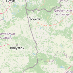
Map view of Ostoja Augustowska

Use this park location map to pinpoint Ostoja Augustowska in Poland, understand its exact geographic position, and read its mapped placement within the surrounding landscape more clearly.

Pigeon | © OpenStreetMap contributors

Location context for Ostoja Augustowska

Podlaskie Voivodeship

Explore photographic records of coniferous woodlands, raised bogs, and protected lowland terrain.

Ostoja Augustowska Photos and Landscapes: Visual Guide to the Primeval Forest

Visual records capture the dense pine forests, dark dystrophic lakes, and open peatland mires defining Ostoja Augustowska. Studying these protected-area habitats reveals the untouched wilderness character and glacial lowland terrain of northeastern Poland.

A dense forest scene with thin tree trunks and lush green undergrowth near a swampy, marshy area.

Park atlas

Compare nearby regional reserves and contiguous forest ecosystems in northeastern Poland

Parks Near Ostoja Augustowska: Discover Surrounding Protected Landscapes and Reserves

Explore other protected areas near Ostoja Augustowska to compare lowland forest ecosystems and wetland habitats across the surrounding region. Analyzing adjacent conservation landscapes reveals broader regional biodiversity patterns and connected wildlife corridors.
Nature reservePodlaskie Voivodeship
Mapped location lies within the park boundary#1 closest

Southeast

Rezerwat przyrody Mały Borek: Pine Bore Forest and Peatland Geography in Podlaskie

Protected nature reserve in the Augustów Primeval Forest

Rezerwat przyrody Mały Borek is a significant nature reserve located in the Podlaskie Voivodeship of Poland. The area is defined by its extensive pine bore forests, central raised bogs, and transition zones of alder swamp. As part of the Natura 2000 network, it provides essential habitat and stands as a key scientific reference for the natural forest landscape of the Augustów Plain.

Area
0.905 km²
Established
1959
Relief
Lowland
Scope
Terrestrial
National parkPodlaskie Voivodeship
Park boundaries overlap#2 closest

Northwest

Wigierski Park Narodowy: Mapped Protected Landscapes of Northeastern Poland

A regional atlas of postglacial terrain and lake ecosystems.

Wigierski Park Narodowy represents a vital expanse of protected land in the Podlaskie Voivodeship. This profile offers insights into its glacial moraine ridges, kettle hole topography, and the specific distribution of forest-fringed bog habitats that define this distinct segment of the Lithuanian Lake District.

Area
150.898 km²
Established
1989
Visitors
110K annual
Relief
Upland
Watercolor illustration showing lakes, green vegetation, and hills in the background
National parkPodlaskie Voivodeship
Park boundaries overlap#3 closest

Northwest

Wigry National Park: Protected Area Atlas of Poland's Glacial Lake District

Explore mapped landscapes and wetland ecosystems in Podlaskie Voivodeship

Delve into the geography of Wigry National Park, a national park situated in the Podlaskie Voivodeship of northeastern Poland. This protected area is defined by its glacial landscape, featuring 42 lakes including the expansive Lake Wigry, alongside critical wetland habitats and significant peat bogs. Discover the mapped boundaries and ecological importance of Wigry National Park, renowned as a prime location for beaver populations and a vital component of Poland's protected lands atlas.

Area
150.86 km²
Established
1989
IUCN
II
Visitors
110K annual
Watercolor painting showing a wetland scene with reeds, patches of water, and trees under a light sky
National parkPodlaskie Voivodeship
Park boundaries overlap#4 closest

Southwest

Biebrza National Park: Protected Fenlands and River Basin Geography in Northeastern Poland

Tracing the largest lowland peat bog complex in the European landscape

Biebrza National Park serves as the premier protected wetland area in Poland, characterized by its vast, intact marshlands and the meandering Biebrza River valley. This geographic profile details the park's critical fen ecosystems, floodplain dynamics, and distinctive habitats that support diverse avian and mammalian populations within the Podlaskie region.

Area
592.23 km²
Established
1993
IUCN
II
Relief
Lowland
A watercolor painting of a flat wetland landscape with a winding river in the foreground, small clusters of trees, and rolling hills in the soft, distant background.
National parkPodlaskie Voivodeship
Park boundaries overlap#5 closest

Southwest

Biebrzański Park Narodowy: A Protected Wetland Landscape in Podlaskie Voivodeship, Poland

Mapped river valley and peatland geography.

Located in the northeast of Poland, Biebrzański Park Narodowy protects a sprawling, flat basin defined by the slow-meandering Biebrza River. This critical protected area encompasses rare peat bogs, floodplain meadows, and alder carrs, functioning as a vital refuge for wetland species within the broader Podlaskie Voivodeship landscape.

Area
592.23 km²
Established
1993
Visitors
23.2K annual
Relief
Lowland
Protected landscapePodlaskie Voivodeship
About 21 km away#6 closest

Northwest

Suwalski Park Krajobrazowy: Glacial Terrain and Protected Landscape Atlas

Mapping the post-glacial geography of Podlaskie Voivodeship

Suwalski Park Krajobrazowy represents a highly distinct glacial environment within the Polish lowlands. Explore the distribution of its iconic morainic landforms, extensive boulder reserves, and the deep basin of Lake Hańcza. The park provides critical geographic context for understanding the interplay between ice-transported geology and local hydrological features in northeastern Poland.

Area
63.38 km²
Established
1976
Relief
Upland
Climate
Temperate
Watercolor illustration showing a landscape with forests, a river, and distant hills
National parkLithuania
30 km away#7 closest

East

Dzūkija National Park: Explore Lithuania's Largest Protected Forest and Inland Dune Landscapes

Mapped protected area geography and natural terrain of the Dainava region.

Delve into the protected landscape of Dzūkija National Park, Lithuania's expansive national park renowned for its vast primeval pine forests and extraordinary inland dune formations. This page provides a detailed atlas-style view of the park's mapped boundaries, diverse terrain, and significant natural features, offering insight into its protected territory and regional geographic importance. Examine the unique wetland systems and forest ecosystems that make this a crucial area for protected land discovery.

Area
584.53 km²
Established
1991
IUCN
II
Visitors
30K annual
Nature reserveWarmian-Masurian Voivodeship
About 42 km away#8 closest

West

Rezerwat przyrody Mazury Nature Reserve: A Protected Lake and Forest Landscape in Poland

Regional geography of the Ełk Lake District and Masurian water landscapes.

This nature reserve safeguards a 388-hectare water and forest mosaic in the Warmian-Masurian Voivodeship. It offers a detailed look at glacial lake ecosystems, forested islands on Lake Piłwąg, and mature mixed deciduous forest stands that represent the classic character of the Masurian landscape.

Area
3.887 km²
Established
1981
Relief
Lowland
Scope
Terrestrial

Common questions about visiting, size, designation, and location context for Ostoja Augustowska

Ostoja Augustowska FAQs for park facts, access, geography, and protected area context

Find quick answers about Ostoja Augustowska, including protected-area facts, park geography, trail and visitor context, and how the park fits into its surrounding country and regional landscape.
MoriAtlas Explorer

Continue Your Protected Areas Search Across the Global Atlas

Deepen your exploration by continuing the structured search for national parks and protected areas worldwide. Utilize the comprehensive filtering capabilities to compare different conservation landscapes and refine your understanding of global park geography. Discover more about the distribution and characteristics of protected natural areas.

Global natural geography