Mori Atlas logo
Nature reservePalm Islands Nature Reserve

Discover the mapped boundaries and critical island geography of this key Mediterranean nature reserve.

Palm Islands Nature Reserve: Lebanon's Vital Protected Coastal Landscape and Marine Ecosystem

Palm Islands Nature Reserve represents a significant protected coastal area in Lebanon, comprising three rocky limestone islands and surrounding marine waters. As a designated nature reserve, it plays a crucial role as a nesting ground for endangered green sea turtles and a sanctuary for Mediterranean monk seals, vital components of the regional marine atlas. This reserve is a key stopover for migratory birds along the Mediterranean Flyway, underscoring its ecological importance within the mapped natural landscapes of the region.

Mediterranean islandsMarine protected areaSea turtle nesting siteMigratory bird habitatRamsar siteLimestone islands

Palm Islands Nature Reserve

Nature reserve

Park overview

Structured park overview, official facts, and landscape profile for Palm Islands Nature Reserve

Palm Islands Nature Reserve park facts, protected area profile, and essential visitor context
Review the core facts for Palm Islands Nature Reserve, including designation, size, terrain, visitor scale, habitats, and operating context in one park-focused overview.

About Palm Islands Nature Reserve

Palm Islands Nature Reserve represents Lebanon's commitment to preserving its Mediterranean coastal and marine biodiversity within a system of protected areas. The three islands, composed primarily of eroded limestone formations, create a unique insular ecosystem where marine and terrestrial environments interact directly. The reserve was officially established in 1992 through Lebanese law declaring the islands and surrounding waters as protected, managed under the authority of the Lebanese Ministry of Environment with daily operations handled by the Mina City Environment Protection Committee. The islands remain in public ownership and were opened to restricted public access in 1999, with visitor access permitted only during the summer months of July through September to minimize disturbance to nesting wildlife. The surrounding marine waters support diverse ecological communities, while the islands themselves contain historical evidence of human occupation spanning from the late Roman period through the Crusades and into the modern era.

Quick facts and research context for Palm Islands Nature Reserve

The Palm Islands Nature Reserve lies off the coast of Tripoli in North Governorate, Lebanon, with the three islands positioned roughly 5.5 kilometres northwest of El Mina. Palm Island, the largest at 180,796 square metres, reaches just 6 metres above sea level and contains approximately 570 palm trees that are irrigated from a restored freshwater well. Ramkine Island, the smallest at 34,903 square metres, rises to 12 metres and bears the remains of an early 20th-century lighthouse with cannon emplacements and underground galleries. The islands feature karstic limestone terrain with marine erosion features, and their sandy shores are composed primarily of biological remains including foraminifera skeletons and marine organism fragments.

Park context

Deeper park guide and search-rich context for Palm Islands Nature Reserve

Palm Islands Nature Reserve history, landscape, wildlife, and travel context
Explore Palm Islands Nature Reserve through its history, landscape character, ecosystems, wildlife, conservation priorities, cultural context, and seasonal travel timing in a structured park guide built for atlas discovery and search intent.

Why Palm Islands Nature Reserve stands out

The Palm Islands are most notably recognized as one of the Mediterranean's critical nesting sites for endangered green sea turtles (Chelona mydas), which use the beaches as primary nesting grounds. The reserve also provides refuge for the rare Mediterranean monk seal, one of the world's most endangered marine mammals. The islands function as a vital stopover and resting area for migratory birds along the East Atlantic Flyway, supporting significant birdlife diversity during seasonal migrations. The reserve's multiple international protection designations underscore its importance as a coastal and marine ecosystem of global significance.

Palm Islands Nature Reserve history and protected-area timeline

The Palm Islands have a rich historical legacy extending over two millennia. Archaeological evidence, including numerous ostraca dating to the late Roman and medieval periods, confirms the islands hosted important settlements with rock-cut cisterns providing freshwater access. The first scientific excavation occurred in October 1973, revealing foundations of several Crusader-era buildings incorporating reused architectural elements from earlier structures. Medieval Arab geographer al-Idrisi documented the islands during the twelfth century, describing them as four islands in a row off Tripoli, named Narcissus Isle, Column Isle, Monk's Isle, and Ardhakun. The Crusaders constructed a church on Palm Island dedicated to Thomas the Apostle, where in 1224 Alice of Champagne married Bohemond V of Antioch in a royal ceremony. The islands later became the site of tragedy in 1289 when Mameluke forces caught panic-stricken residents fleeing to the island; many took refuge in the church where they were massacred. The islands were subsequently abandoned for centuries before modern rehabilitation works restored the freshwater well, constructed a boat dock, and established walking trails for visitors.

Palm Islands Nature Reserve landscape and geographic character

The physical landscape of the Palm Islands consists of flat, eroded limestone terrain with minimal relief, characteristic of marine limestone formations subjected to long-term erosion processes. The islands display typical karstic features resulting from both marine and aerial erosion, with open gutters varying in width depending on exposure to wave action versus atmospheric conditions. Palm Island, the largest, features rocky shorelines along its northwestern to southern extent while sandy beaches occupy the northern and eastern faces. The island's central area contains earthen ground with evidence of historical human occupation, including a restored freshwater well and remains of salt evaporation ponds. The sandy shores and dunes are biologically formed, composed predominantly of foraminifera skeletons giving the sand a distinctive light coloration, mixed with gastropod shell fragments and echinoderm skeletal material. Ramkine Island rises more prominently to approximately 12 metres above sea level, supporting the remains of a lighthouse and associated defensive structures from the early 20th century.

Palm Islands Nature Reserve ecosystems, habitats, and plant life

The Palm Islands support a distinctive ecological environment where Mediterranean marine and island terrestrial systems converge. The shallow orthent soils found on rocky island portions support ephemeral flora that emerges during the wet season when fresh water accumulates in limestone crevasses. More developed soils in western Palm Island areas formed through aeolian processes and beach-deposited calcareous sands provide substrate for the island's characteristic palm vegetation. The surrounding marine environment contains productive shallow waters supporting marine food chains critical to sea turtle and monk seal foraging. The islands' position along major migratory bird routes creates seasonal pulses of avian activity, with resting and nesting birds utilizing the coastal habitats. The overall ecosystem represents a fragile interface between marine and terrestrial domains, where biodiversity concentrates due to the isolated island setting and protected status.

Palm Islands Nature Reserve wildlife and species highlights

The Palm Islands Nature Reserve serves as a critical refuge for several globally threatened species, most notably the endangered green sea turtle (Chelona mydas) which uses the islands' sandy beaches as primary nesting habitat. The surrounding waters provide foraging grounds for these marine reptiles throughout their lifecycle. The reserve also shelters populations of the Mediterranean monk seal, one of the world's rarest and most endangered seal species, which utilizes the islands' rocky shores and adjacent waters as resting and breeding habitat. The islands function as an Important Bird Area, providing essential stopover habitat for migratory birds traversing the Mediterranean during seasonal migrations between Europe, Africa, and beyond. The combination of nesting marine reptiles, endangered marine mammals, and migratory bird concentrations makes this small island reserve disproportionately important for Mediterranean biodiversity conservation.

Palm Islands Nature Reserve conservation status and protection priorities

The Palm Islands Nature Reserve holds multiple international conservation designations reflecting its significant ecological value. Designation as a Ramsar Wetland of Special International Importance in 1980 recognized the islands' role as critical coastal wetland habitat. The reserve was later designated as a Mediterranean Specially Protected Area under the 1995 Barcelona Convention, providing framework for regional marine and coastal protection cooperation. BirdLife International's identification as an Important Bird Area acknowledges the islands' significance for migratory bird populations. The 1992 legal declaration establishing protected status was reinforced by specific management structures, including the Mina City Environment Protection Committee and dedicated ranger presence. The reserve faced significant environmental stress from the 2006 Jiyeh Power Station oil spill, which coated island shores and required clean-up and monitoring intervention by the International Union for Conservation of Nature to mitigate damage to turtles, birds, and marine organisms.

Palm Islands Nature Reserve cultural meaning and human context

The Palm Islands carry deep historical significance within the broader context of Lebanon's Mediterranean coastal heritage. The islands appear in medieval geographic literature, particularly in the works of twelfth-century Arab geographer al-Idrisi who documented their names and positions relative to Tripoli when the city was under Crusader rule. The Crusader presence is physically attested by the remains of a church on Palm Island, built atop earlier settlement layers and later the site of a significant historical event: the 1224 royal wedding between Alice of Champagne and Bohemond V of Antioch. The tragic 1289 massacre when Mamelukes caught fleeing residents who had sought refuge in the church marked a dark chapter in the islands' history. The French Mandate period in the early 20th century saw rabbit farming operations that gave Palm Island its alternative name Rabbits Island. The islands' cultural landscape includes the restored well, old salt evaporation ponds, and the lighthouse on Ramkine Island with its associated defensive cannon emplacements and underground galleries.

Top sights and standout views in Palm Islands Nature Reserve

The Palm Islands combine natural and cultural significance within a compact Mediterranean island reserve. Endangered green turtle nesting beaches represent one of the Mediterranean's most important reptile conservation sites. The rare Mediterranean monk seal finds refuge in the reserve's marine waters and rocky shores. Historical layers from Roman through Crusader periods are embedded in the island landscape, with the church ruins representing tangible connections to medieval Levantine history. The summer-only visitor access period reflects careful balance between public engagement and ecological protection. The three distinct islands each offer different character: Palm Island's palm groves and sandy beaches, Sanani's rocky terrain, and Ramkine's elevated position with lighthouse heritage.

Best time to visit Palm Islands Nature Reserve

The Palm Islands Nature Reserve permits public access only during the summer months, typically July through September, when conditions are most suitable for visitors and wildlife disturbance is minimized. This restricted access period aligns with optimal weather conditions for boat transit to the islands and outdoor exploration. However, the reserve may close even during this permitted window if environmental research or conservation work is underway. The summer season offers warm, dry conditions ideal for beach access and island walking trails, though visitors should expect higher temperatures typical of the eastern Mediterranean. Wildlife viewing opportunities differ seasonally, with nesting activity for turtles occurring earlier in the year and migratory bird presence concentrated during spring and autumn passage periods.
Park location guide

Geography guide, regional context, and park location map for Palm Islands Nature Reserve

Palm Islands Nature Reserve park geography, regions, and map view in Lebanon
Understand where Palm Islands Nature Reserve sits in Lebanon through a broader geographic reading of the surrounding landscape, nearby location context, and its mapped position within the national park landscape.

How Palm Islands Nature Reserve fits into Lebanon

Lebanon is a unitary parliamentary republic under confessionalism with a population of over 5 million. Located on the Mediterranean coast at the crossroads of ancient trade routes, it has a diverse religious composition with Islam and Christianity as the main faiths. The country has historical roots dating to Phoenicia and has been ruled by Romans, Byzantines, Ottoman Empire, and France.

Wider geography shaping Palm Islands Nature Reserve in Lebanon

Lebanon is located in the Levant region of West Asia on the eastern Mediterranean coast. It is bordered by Syria to the north and east, Israel to the south, and the Mediterranean Sea to the west. The country has a small territory of 10,452 square kilometres, with a narrow coastal plain and mountainous interior including the Lebanon Mountains.

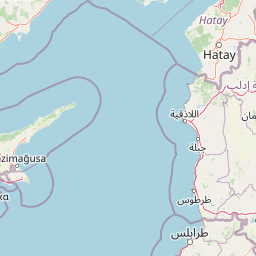
Map view of Palm Islands Nature Reserve

Use this park location map to pinpoint Palm Islands Nature Reserve in Lebanon, understand its exact geographic position, and read its mapped placement within the surrounding landscape more clearly.

Pigeon | © OpenStreetMap contributors
Park atlas

Compare coastal ecosystems and marine reserves across the surrounding Lebanese region.

Parks and Protected Areas Near Palm Islands Nature Reserve for Geographic Discovery
Explore additional protected areas, marine reserves, and coastal landscapes adjacent to Palm Islands Nature Reserve within Lebanon and the broader Mediterranean region. Compare diverse natural habitats and trace the geographic spread of protected ecosystems, deepening your atlas-style understanding of regional conservation efforts.
Nature reserveLebanon

Horsh Ehden Nature Reserve: Protected Nature Reserve within Lebanon's Regional Geography

Explore mapped protected land and natural terrain.

Horsh Ehden Nature Reserve is identified as a critical protected area within Lebanon. This page facilitates an atlas-style exploration of the reserve's specific geographic footprint, highlighting its mapped boundaries and the distinct natural terrain it preserves. Understanding Horsh Ehden Nature Reserve's role as a nature reserve contributes to a broader appreciation of protected landscapes and their regional context.

Area
17.4 km²
Established
1992
IUCN
Ib
Relief
Mountain
Nature reserveNorth Lebanon Governorate

Tannourine Cedar Forest Nature Reserve: A Premier Protected Cedar Landscape in North Lebanon

Mapped geography of Lebanon's largest cedar forest.

Delve into the Tannourine Cedar Forest Nature Reserve, a protected area critically important for its extensive cedar groves within the North Lebanon Governorate. This nature reserve encompasses a complex mountain geography characterized by deep ravines, imposing cliffs, and secluded caves, providing a dramatic backdrop for its dominant cedar population. Users can explore the mapped boundaries and understand the regional landscape context of this ecologically significant coniferous forest, essential for Lebanon's natural atlas.

Area
1.955 km²
Established
1999
IUCN
IV
Relief
Mountain
Nature reserveKeserwan District

Jabal Moussa Biosphere Reserve: Lebanon's Protected Nature Reserve with Distinct Geographic Identity

Mapped protected landscape within Keserwan District's regional geography.

Jabal Moussa Biosphere Reserve represents a crucial protected area in Lebanon, defined by its unique natural landscape and mapped boundaries. Positioned within the Keserwan District, this nature reserve offers valuable insights for geographic exploration and understanding protected land distribution. Its inclusion in the MoriAtlas platform highlights its significance for regional conservation and atlas-style discovery of Lebanon's natural terrain.

Area
65 km²
Established
2009
Relief
Mountain
Climate
Mediterranean
Biosphere reserveLebanon

Aammiq Wetland Biosphere Reserve: Mapping Lebanon's Crucial Freshwater Protected Landscape

Discover its geography, mapped terrain, and role as a biodiversity hotspot.

Aammiq Wetland is Lebanon's most significant freshwater protected area, recognized as a UNESCO Biosphere Reserve and Ramsar site. Its unique geography, characterized by extensive reedbeds and open pools fed by mountain snowmelt, makes it a vital stopover for countless migratory bird species traversing the Middle East. This protected landscape offers rich opportunities for atlas-style exploration, revealing the ecological importance of its mapped terrain and its role as a critical biodiversity hotspot.

Area
2.53 km²
Established
1999
IUCN
IV
Relief
Lowland
Nature reserveLebanon

Al Shouf Cedar Nature Reserve: A Protected Landscape in Lebanon's Geography

Explore its mapped natural terrain and protected boundaries.

Investigate Al Shouf Cedar Nature Reserve, a protected natural area situated within Lebanon. This page offers a detailed view of its protected landscape identity and geographic context, crucial for understanding its placement within the region's natural atlas. Examine the mapped terrain and park boundaries that distinguish this significant nature reserve.

Area
550 km²
Established
1996
Relief
Mountain
Climate
Temperate
Nature reserveLebanon

Tyre Coast Nature Reserve: Lebanon's Protected Nature Reserve Geography and Atlas Mapping

Discover the mapped natural landscape and regional context.

Tyre Coast Nature Reserve represents a distinct protected area within Lebanon, offering a unique focus for geographic exploration. This entry provides detailed insights into its mapped boundaries, situating it within the broader natural landscape and regional geography of the country. Engage with the structured atlas data to understand the specific protected land identity and geographic characteristics of this nature reserve.

Area
3.8 km²
Established
1998
Relief
Lowland
Climate
Mediterranean
National parkIsrael

Bar'am National Park: Preserving Ancient Jewish Heritage and Galilee Landscape

Explore significant Talmudic-era synagogues and borderland geography.

Bar'am National Park is an important archaeological site in Israel's upper Galilee, renowned for its remarkably preserved ancient Jewish synagogues dating to the Talmudic period. These structures represent significant tangible evidence of Jewish religious life and architectural styles from late antiquity. Situated amidst the rolling hills of the Galilee countryside, the park's landscape offers a unique combination of historical reflection and scenic views towards the Lebanese border, making it a key destination for understanding regional heritage and geography.

Relief
Upland
Access
Moderate access
Scope
Terrestrial
Water
No major water
National parkIsrael

Yehi'am Fortress National Park: National Park with Protected Landscape Identity in Israel

Discover its mapped geographic boundaries and regional landscape context.

Yehi'am Fortress National Park is a key protected area situated within the geographic landscape of Israel. This national park entry provides structured insights into its distinct natural features and its role as a mapped protected zone. Explore the regional context and unique geographic identity of Yehi'am Fortress National Park, contributing to a broader understanding of Israel's conservation landscapes.

Relief
Upland
Access
Moderate access
Scope
Terrestrial
Water
No major water

Common questions about visiting, size, designation, and location context for Palm Islands Nature Reserve

Palm Islands Nature Reserve FAQs for park facts, access, geography, and protected area context
Find quick answers about Palm Islands Nature Reserve, including protected-area facts, park geography, trail and visitor context, and how the park fits into its surrounding country and regional landscape.
MoriAtlas Explorer

Continue Your Protected Areas Search Across the Global Atlas

Deepen your exploration by continuing the structured search for national parks and protected areas worldwide. Utilize the comprehensive filtering capabilities to compare different conservation landscapes and refine your understanding of global park geography. Discover more about the distribution and characteristics of protected natural areas.

Global natural geography