Mori Atlas logo
National parkPatagonia National Park

Discover the mapped boundaries and regional terrain of this significant national park.

Patagonia National Park Chile: Protected Landscape & Geographic Context in Aysén Region

(Parque Nacional Patagonia)

Patagonia National Park stands as a protected landscape within Chile's Aysén Region, offering unique opportunities for geographic and map-based discovery. This park represents a vital component of the region's protected areas, providing a distinct geographic setting for exploration. Users can delve into its specific location, understand its mapped boundaries, and explore the natural terrain that defines this significant national park within a broader atlas context.

National ParkPatagoniaAysén RegionSouthern AndesGrassland EcosystemForest Ecosystem

Patagonia National Park

National park

Park overview

Structured park overview, official facts, and landscape profile for Patagonia National Park

Patagonia National Park park facts, protected area profile, and essential visitor context
Review the core facts for Patagonia National Park, including designation, size, terrain, visitor scale, habitats, and operating context in one park-focused overview.

About Patagonia National Park

Patagonia National Park represents one of the most significant recent additions to Chile's national park system, born from a unique public-private partnership in conservation. The park's core is the Chacabuco Valley, an east-west corridor that forms a natural pass over the Andes Mountains, creating an ecologically vital transition zone between the grasslands of Argentine Patagonia and the forests of Chilean Patagonia. This geographic position gives the park extraordinary biodiversity, encompassing steppe ecosystems, riparian forests, and wetland habitats within its boundaries. The transformation of this landscape from a heavily grazed sheep ranch to a protected wilderness represents one of the most ambitious restoration projects in South America. Visitors can explore the park through an extensive network of trails that traverse diverse ecosystems, with the central Lodge at Valle Chacabuco serving as the main hub for visitor services, including accommodations, dining, and educational exhibits about the park's ecology and conservation history.

Quick facts and research context for Patagonia National Park

Located in Chile's Aysén Region, Patagonia National Park occupies the Chacabuco Valley at the crossroads of two major ecosystems. The park was formally designated in 2018 following a decade-long restoration effort by Conservación Patagónica, transforming former sheep ranchland into protected wilderness. It encompasses diverse habitats from arid steppe to temperate forest, providing refuge for endangered species including the huemul deer and serves as a model for large-scale ecosystem restoration in Patagonia.

Park context

Deeper park guide and search-rich context for Patagonia National Park

Patagonia National Park history, landscape, wildlife, and travel context
Explore Patagonia National Park through its history, landscape character, ecosystems, wildlife, conservation priorities, cultural context, and seasonal travel timing in a structured park guide built for atlas discovery and search intent.

Why Patagonia National Park stands out

Patagonia National Park is best known for its unique position at the ecological boundary between the Patagonian steppe and the Magellanic forests, creating a remarkable diversity of landscapes within a single protected area. The park has become a symbol of successful private conservation efforts, having been created through the vision and land donation of Tompkins Conservation. It is renowned for its ambitious ecosystem restoration program that has removed hundreds of kilometers of fencing, re-established native grasslands, and created habitat corridors for endangered huemul deer. The park also features the striking Chacabuco Valley, which serves as a natural pass through the Andes, and contains a network of trails and campgrounds centered around a visitor facility that exemplifies sustainable park infrastructure.

Patagonia National Park history and protected-area timeline

The land that now comprises Patagonia National Park has undergone multiple transformations over the past century. Originally established as a sheep ranch by British explorer Lucas Bridges in 1908, the Estancia Valle Chacabuco became one of the region's largest livestock operations, supporting nearly 25,000 animals annually. In 1964, under President Eduardo Frei Montalva's administration, the land was expropriated and distributed among local families, though the Pinochet regime later reclaimed it and sold it to a Belgian landowner in 1980. The property remained in private hands until 1995 when Kris and Doug Tompkins first visited the Chacabuco Valley. Recognizing its exceptional conservation value, as identified by CONAF over decades, Conservación Patagónica purchased the 70,600-hectare estate in 2004 and began systematically acquiring additional properties to create a contiguous protected area. On January 29, 2018, Chilean President Michelle Bachelet and Kris Tompkins signed a decree establishing Patagonia National Park, combining the former ranchland with Lago Jeinimeni National Reserve and Lago Cochrane National Reserve to form a 260,000-hectare protected complex.

Patagonia National Park landscape and geographic character

The park's dramatic landscape reflects its position at the intersection of two distinct ecological regions. The eastern portion features the arid Patagonian steppe, characterized by minimal rainfall, cold winds, and sandy soils supporting hardy shrubs and tuft grasses. As the terrain rises toward the Andes to the west, the landscape transforms into dense forests dominated by southern beech species including lenga, ñire, and coiue. The Chacabuco Valley itself serves as a natural corridor, with glacier-fed streams and rivers running westward toward the Pacific Ocean despite the park's position on the eastern side of the continental divide. The terrain includes rolling grasslands, forest-lined watercourses, and mountain vistas that define the Patagonian wilderness character.

Patagonia National Park ecosystems, habitats, and plant life

The park's location at the crossroads of the Patagonian steppe and the Magellanic subpolar forests creates an exceptional diversity of habitats within a single protected area. The steppe ecosystem supports specialized flora including calafate, quilembay, and yaoyín shrubs, along with native coirón grasses adapted to arid conditions. The forest ecosystem on the western slopes receives high rainfall and supports dense vegetation with remarkable biodiversity, including 370 vascular plant genera. Wetlands and riparian corridors add additional ecological diversity, providing critical habitat for waterfowl and amphibians. The park's restoration has focused on reconnecting these habitats by removing fencing that previously fragmented the landscape.

Patagonia National Park wildlife and species highlights

Patagonia National Park provides critical habitat for several threatened species, most notably the endangered huemul deer, which persists in only small populations across its historic range. The park supports an estimated 100 to 200 huemul individuals, representing one of the largest known surviving populations on Earth. Puma populations thrive in the park, serving as keystone predators, while guanacos roam the steppe as the most abundant herbivore in Patagonia. The avifauna is exceptionally diverse, featuring the Andean condor, Magellanic woodpecker, black-necked swan, Chilean flamingo, and numerous other species. The park's streams support native fish species including perch, pejerrey patagonico, and puyen, as well as introduced trout species.

Patagonia National Park conservation status and protection priorities

The creation of Patagonia National Park represents a landmark achievement in large-scale landscape conservation and ecosystem restoration. The park serves as a model for restoring degraded Patagonian grasslands, having removed over half of the 640 kilometers of fencing that previously fragmented wildlife habitat. Native grass restoration efforts using locally collected seeds have helped reverse desertification processes caused by decades of intensive sheep ranching. The recovery of the huemul deer remains the highest conservation priority, with population tracking and protection programs in place, while puma monitoring through GPS collars provides crucial data for understanding predator-prey dynamics. The park's visitor infrastructure demonstrates sustainability through renewable energy systems and local materials, minimizing the environmental footprint of protected area management.

Patagonia National Park cultural meaning and human context

The park sits within the broader Patagonian landscape that has been shaped by human activity over more than a century, particularly through the establishment of Estancia Valle Chacabuco as a major sheep ranching operation. The conservation project has actively engaged local communities by employing former gauchos as park rangers and conservation workers, providing employment in a region with limited economic opportunities. Educational outreach programs bring local children into the park to learn about conservation, while annual events like the Huemul Festival build community connection to the park's mission. The park represents a transition from the region's pastoral heritage to a new economy based on ecological stewardship and sustainable tourism.

Best time to visit Patagonia National Park

The park operates seasonally from October through April, corresponding with Patagonia's spring and summer months when conditions are most suitable for visitor activities. During this period, the weather ranges from cool to mild, with longer daylight hours allowing extended exploration of the trail network. The summer months typically offer the most stable conditions for backcountry travel, though weather in Patagonia can change rapidly regardless of season. Visitors should be prepared for variable conditions and the park's remote location, which requires planning for self-sufficiency during backcountry excursions.

Park location guide

Geography guide, regional context, and park location map for Patagonia National Park

Patagonia National Park park geography, regions, and map view in Chile
Understand where Patagonia National Park sits in Chile through a broader geographic reading of the surrounding landscape, nearby location context, and its mapped position within the national park landscape.

How Patagonia National Park fits into Chile

Chile is a presidential republic in western South America, extending as a narrow strip along the western edge of the continent between the Andes Mountains and the Pacific Ocean. It is the southernmost country in the world and the closest to Antarctica. The country is bordered by Peru, Bolivia, and Argentina, and administers several Pacific islands including Easter Island. Chile is a major copper producer and has a population of approximately 19.6 million.

Wider geography shaping Patagonia National Park in Chile

Chile occupies a narrow strip of land along the western edge of South America, extending approximately 4,300 km north to south but only about 350 km east to west at its widest point. The country is sandwiched between the Andes Mountains to the east and the Pacific Ocean to the west. It shares borders with Peru to the north, Bolivia to the northeast, and Argentina to the east. Southern Chile borders the Drake Passage. Chile also administers several Pacific islands including Juan Fernández Islands, Isla Salas y Gómez, Desventuradas Islands, and Easter Island, plus the Chilean Antarctic Territory.

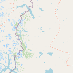
Map view of Patagonia National Park

Use this park location map to pinpoint Patagonia National Park in Chile, understand its exact geographic position, and read its mapped placement within the surrounding landscape more clearly.

Pigeon | © OpenStreetMap contributors

Location context for Patagonia National Park

Aysén Region
Park atlas

Uncover the geographic spread of protected landscapes within Chile's Aysén Region and the broader Patagonian frontier.

Explore National Parks and Protected Areas Adjacent to Patagonia National Park, Chile
After exploring Patagonia National Park, discover other national parks and protected areas across Chile's Aysén Region and the broader Patagonian steppe. Compare diverse landscapes from arid grasslands to dense southern beech forests, gaining richer geographic context for the region's expansive protected-area networks.
National park

Perito Moreno National Park: Argentina's Expansive Patagonian Protected Landscape

Explore its mapped terrain and significant protected area geography.

Perito Moreno National Park stands as a cornerstone of Argentinian conservation, safeguarding over 126,000 hectares of striking Patagonian mountain wilderness. This national park protects a rare ecological transition zone, blending wet Andean forests with dry steppe environments across its dramatic amphitheater-like terrain and dual-watershed hydrography. Its mapped boundaries encompass significant natural geography, offering a clear atlas view of protected Patagonian landscapes.

Area
1,268.3 km²
Established
1937
IUCN
II
Relief
Mountain
National park

Patagonia National Park: A National Park Protecting the Argentine Patagonian Steppe Landscape

Explore the mapped boundaries of this semi-arid grassland ecosystem.

Patagonia National Park is a protected national park in Argentina established to preserve the representative Patagonian steppe ecosystem. Covering 528.11 square kilometers, it offers a deep dive into the unique semi-arid grassland environment, known for its rolling plains and wind-shaped terrain. This park provides crucial context for understanding the broader geography of southern Argentina and the conservation of its distinctive natural landscapes.

Area
528.11 km²
Established
2015
IUCN
II
Climate
Arid
National parkAysén del General Carlos Ibáñez del Campo Region

Laguna San Rafael National Park: Explore its Mapped Boundaries and Patagonian Landscape

A National Park within Aysén del General Carlos Ibáñez del Campo Region.

Laguna San Rafael National Park stands as a key protected area within the vast geography of the Aysén del General Carlos Ibáñez del Campo Region. This entry provides an atlas-focused perspective, detailing the park's geographic significance, mapped natural landscapes, and its role as a vital conservation territory. Understand how this national park fits into the broader context of Patagonia's unique terrain and protected areas.

Area
17,420 km²
Established
1959
IUCN
II
Relief
Mountain
National parkAysén del General Carlos Ibáñez del Campo Region

Cerro Castillo National Park: Dramatic Granite Peaks and Patagonian Protected Landscape

Mapped geography and huemul conservation in Chile's Aysén Region.

Cerro Castillo National Park is a premier protected area in southern Chile, celebrated for its iconic Cerro Castillo granite mountain that dominates the landscape. This national park, spanning over 1,700 square kilometers in the Aysén del General Carlos Ibáñez del Campo Region, showcases a dynamic Patagonian terrain shaped by glaciers and rivers. Its significance extends to being a vital corridor for endangered huemul, offering critical habitat within a broader regional conservation strategy and the famous Route of Parks.

Area
1,795.5 km²
Established
1970
IUCN
II
Relief
Mountain
National parkAysén del General Carlos Ibáñez del Campo Region

Isla Magdalena National Park: Protected Area and Regional Geography Context

Discover the mapped landscape of this national park.

Delve into the protected landscape of Isla Magdalena National Park, a key national park situated in the Aysén del General Carlos Ibáñez del Campo Region of Chile. This entry provides essential geographic context, focusing on the park's mapped boundaries and its role within the Patagonian environment. Understand its distinct identity as a protected area for structured atlas exploration.

Area
1,576 km²
Established
1983
IUCN
II
Relief
Mountain
Watercolor illustration of rolling hills, a river flowing through a valley, and forested areas
National parkAysén del General Carlos Ibáñez del Campo Region

Queulat National Park: Patagonian Andes Glacier and Rainforest Discovery

Mapped protected area in Aysén del General Carlos Ibáñez del Campo Region.

Queulat National Park is a vast protected wilderness in southern Chile, renowned for its dramatic glacial alpine terrain and lush temperate rainforests. The park's geography is defined by steep glacial valleys, ice fields, and the iconic Queulat Hanging Glacier cascading from sheer cliffs. Discover the mapped boundaries of this significant Patagonian national park, offering unparalleled insight into its unique ecosystems and dramatic landscapes shaped by ice and forest.

Area
1,541 km²
Established
1983
IUCN
II
Relief
Mountain
National park

Los Glaciares National Park: Argentinian National Park with Patagonian Ice Fields

Explore glacial terrain and iconic Andes peaks.

Los Glaciares National Park is a vast protected area in Argentina, dominated by a massive Patagonian ice cap and numerous descending glaciers, including the renowned Perito Moreno Glacier. Its dramatic landscape of ice fields, glacial lakes, and towering granite spires like Mount Fitz Roy provides critical context for understanding regional geography and the formation of glacial terrain. This park exemplifies the unique protected ecosystems of the southern Andes, offering rich detail for atlas-based discovery.

Area
7,269.27 km²
Established
1937
IUCN
II
Visitors
688.8K annual
Watercolor illustration of a mountainous landscape with green fields and forests under a pale sky
National parkAysén Region

Melimoyu National Park: A Key Protected National Park within Chile's Aysén Region

Explore Melimoyu National Park's mapped boundaries and regional geography.

Melimoyu National Park stands as a distinct protected natural area, offering a focused lens for geographic discovery. As a national park situated in the Aysén Region, its mapped boundaries and regional landscape context are crucial for understanding its atlas significance. This entry provides specific details about the park's protected status and its contribution to the mapped terrain of southern Chile, enabling detailed exploration for atlas enthusiasts.

Area
1,055 km²
Established
2018
IUCN
II
Relief
Mixed relief

Common questions about visiting, size, designation, and location context for Patagonia National Park

Patagonia National Park FAQs for park facts, access, geography, and protected area context
Find quick answers about Patagonia National Park, including protected-area facts, park geography, trail and visitor context, and how the park fits into its surrounding country and regional landscape.
MoriAtlas Explorer

Continue Your Protected Areas Search Across the Global Atlas

Deepen your exploration by continuing the structured search for national parks and protected areas worldwide. Utilize the comprehensive filtering capabilities to compare different conservation landscapes and refine your understanding of global park geography. Discover more about the distribution and characteristics of protected natural areas.

Global natural geography