

Mori Atlas logo
National parkPhawngpui National Park

Discover the mapped boundaries and regional context of this protected area in India.

Phawngpui National Park: India's Protected Landscape and National Park Geography

(Phawngpui Blue Mountain National Park)

Phawngpui National Park represents a key protected landscape within India, offering a unique lens through which to explore the country's natural geography. This national park entity provides vital context for understanding regional park distribution and mapped terrain. Engage with its specific geographic setting and protected-area identity to enhance your atlas exploration and appreciate the mapped natural features of this South Asian nation.

National ParkMountain Protected AreaCloud ForestBiodiversity HotspotNortheast IndiaMontane Grassland

Phawngpui National Park

National park

Park overview

Structured park overview, official facts, and landscape profile for Phawngpui National Park

Phawngpui National Park park facts, protected area profile, and essential visitor context
Review the core facts for Phawngpui National Park, including designation, size, terrain, visitor scale, habitats, and operating context in one park-focused overview.

About Phawngpui National Park

Phawngpui National Park occupies a remote and ecologically significant position in northeastern India, protecting the mountainous terrain around Mizoram's highest peak. The park's establishment in 1992 marked an important milestone in the conservation of the state's natural heritage, as it encompasses the entire Phawngpui massif along with surrounding reserve forest areas. The landscape is characterized by steep, often sharp precipices along the mountain edges, with the prominent western cliff known as Thlazuang Khâm creating a spectacular semi-circular rock face with a blunt, deep fall. The mountain ridge runs approximately 10 kilometres in a north-south orientation, with the Chhimtuipui river flowing past the park's boundaries toward Burma. The area experiences persistent cloud cover, particularly during monsoon periods, which contributes to the blue appearance that gave the mountain its English name. The local Lai language name itself reflects the landscape's character, with "phawng" meaning meadow and "pui" meaning great, referring to the extensive grassy areas that occur throughout the park. Visitors are permitted only during the dry season from November to April, allowing the park's ecosystems to remain undisturbed during the critical monsoon period.

Quick facts and research context for Phawngpui National Park

Phawngpui National Park spans 50 square kilometres in Lawngtlai district, Mizoram, protecting the state's highest peak at 2,157 metres. The mountain appears blue from a distance due to persistent cloud cover, giving rise to its common name. The park contains steep cliffs including the dramatic Thlazuang Khâm on the western face, with the mountain ridge extending roughly 10 kilometres in a north-south direction. The climate is mild year-round with temperatures ranging from 11 to 29 degrees Celsius, and the area receives approximately 3,000 centimetres of average rainfall. The closest settlement is Thaltlang village at the park's periphery. The park is open to ecofriendly visitors only during the dry season from November through April.

Park context

Deeper park guide and search-rich context for Phawngpui National Park

Phawngpui National Park history, landscape, wildlife, and travel context
Explore Phawngpui National Park through its history, landscape character, ecosystems, wildlife, conservation priorities, cultural context, and seasonal travel timing in a structured park guide built for atlas discovery and search intent.

Why Phawngpui National Park stands out

Phawngpui National Park is best known for protecting Phawngpui, the Blue Mountain of Mizoram, which stands as the highest mountain in the state and holds significant cultural and ecological importance. The park shelters rare wildlife including the clouded leopard, first documented in the area in 1997, as well as Blyth's tragopan, Mrs. Hume's pheasant (Mizoram's state bird), and populations of tigers, leopards, and Asiatic black bears. The spectacular Thlazuang Khâm cliff on the western side of the mountain, with its semi-circular formation and dramatic drop, represents one of the most visually striking landscape features in the park. The area is also renowned for its rhododendron and orchid diversity, with steep slopes carpeted in these flowering plants alongside extensive bamboo groves.

Phawngpui National Park history and protected-area timeline

Phawngpui National Park was established in 1992 as a protected area under Indian national park legislation, representing Mizoram state's commitment to conserving its unique montane ecosystems and biodiversity. The park was created to protect the Phawngpui mountain, which had long held significance as the highest peak in Mizoram and a landmark of cultural importance to local communities. The establishment of the park formalised protection for the mountain and surrounding reserve forest, bringing the area under the management of the Department of Environment and Forests of the Government of Mizoram. Prior to formal protection, the area had been managed as reserve forest, but the national park designation elevated its conservation status and provided stronger legal protections against habitat degradation and wildlife exploitation. The park remains one of two national parks in Mizoram, alongside the larger Murlen National Park, together forming the cornerstone of the state's protected area network.

Phawngpui National Park landscape and geographic character

The physical landscape of Phawngpui National Park is defined by its dramatic mountain terrain and the unique atmospheric conditions that give the peak its distinctive blue appearance. The mountain rises to 2,157 metres above sea level as the highest point in Mizoram, with its upper reaches frequently shrouded in thin cloud layers that scatter light to create the blue coloration visible from a distance. The mountain ridge extends roughly 10 kilometres in a north-south direction, with the terrain characterized by very steep edges and numerous sharp precipices. The most spectacular geological feature is Thlazuang Khâm, a semi-circular cliff on the western face of the mountain that presents a blunt, deep vertical drop. The landscape overlooks the Chhimtuipui (Kolodyne) river as it flows toward Burma, creating an important watershed boundary. The combination of high rainfall, persistent cloud cover, and steep terrain has shaped the distinctive character of the area, with the climate remaining mild throughout the year despite the tropical latitude due to the elevation and cloud forest conditions.

Phawngpui National Park ecosystems, habitats, and plant life

The ecological character of Phawngpui National Park reflects its position within the Indo-Burma biodiversity hotspot, one of the world's most significant centres of biological diversity. The park encompasses a range of habitat types across its elevation gradient, from montane grasslands at the lower slopes to cloud forest and rhododendron-dominated vegetation near the summit. The name itself reveals the ecological importance of the grasslands, with "phawng" meaning meadow in the local Lai dialect, indicating the extensive grassy areas that historically covered the mountain. Bamboo forest occurs in substantial areas throughout the park, while the steep slopes support diverse orchid and rhododendron communities that bloom seasonally. The area's high rainfall of approximately 3,000 centimetres annually supports lush vegetation and maintains the humid conditions necessary for cloud forest formation. This combination of grasslands, bamboo forest, and montane evergreen vegetation creates a mosaic of habitats that supports the park's remarkable biodiversity.

Phawngpui National Park wildlife and species highlights

Phawngpui National Park supports a notable array of wildlife, with particular significance attached to several rare and endangered species. The clouded leopard was first documented in the park in 1997, representing the first confirmed record of this elusive big cat in Mizoram and highlighting the park's importance for large mammal conservation. The avifauna includes the rare Blyth's tragopan, Mrs. Hume's pheasant (which serves as Mizoram's state bird), dark-rumped swift, and various sunbird species. Additional bird species recorded include mountain bamboo partridge, oriental pied hornbill, purple cochoa, striped laughingthrush, grey sibia, black eagle, and large-billed crow. The mammal community includes tigers, leopards, leopard cats, Asiatic black bears, serows, gorals, and the slow loris. Primates present include the capped langur and stump-tailed macaque, while the mountain goat, though mentioned in sources, likely refers to the serow or goral. This diversity of species positions the park as a critical area for wildlife conservation in northeastern India.

Phawngpui National Park conservation status and protection priorities

Phawngpui National Park represents an important conservation priority within Mizoram and the broader Indo-Burma region, protecting both representative montane ecosystems and significant populations of threatened species. The park's establishment formalized protection for Mizoram's highest mountain and the unique habitats it supports, including cloud forests, grasslands, and bamboo thickets that would otherwise face pressure from human activities. The presence of the clouded leopard, confirmed through documentation in 1997, demonstrates the park's value for conserving large carnivores in a region where habitat fragmentation poses significant challenges. The protection of Mrs. Hume's pheasant as the state bird within the park underscores the area's ornithological significance. Visitor access is restricted to the dry season from November through April, a management approach that allows ecological processes to continue unimpeded during the monsoon period and supports natural regeneration. The park forms part of Mizoram's protected area network alongside Murlen National Park, together providing conservation coverage for the state's most significant mountain ecosystems.

Phawngpui National Park cultural meaning and human context

Phawngpui holds deep cultural significance for the people of Mizoram, with the mountain known as the Blue Mountain representing a prominent landmark in local identity and tradition. The name itself carries linguistic meaning in the Lai dialect, where "phawng" translates to meadow and "-pui" means great, collectively describing the mountain as the great meadow. This etymology reflects the historical importance of the grasslands that characterise the landscape and their role in local culture and subsistence. The park lies in the Lawngtlai district, home to indigenous communities whose traditional practices and land-use patterns have shaped the surrounding landscape over generations. Thaltlang village at the base of the mountain represents the closest human settlement to the park boundary. The mountain's prominence as the highest peak in Mizoram has made it a symbol of state identity, while its proximity to the Burma border underscores the region's position at the crossroads of South and Southeast Asian cultural and ecological zones.

Top sights and standout views in Phawngpui National Park

The defining highlight of Phawngpui National Park is the opportunity to experience India's highest peak in Mizoram, with the mountain's distinctive blue appearance created by persistent cloud cover providing a memorable visual signature. The spectacular Thlazuang Khâm cliff on the western face offers one of the most dramatic geological features in northeastern India, with its semi-circular formation creating a striking backdrop for visitors. Wildlife enthusiasts may encounter the elusive clouded leopard, Blyth's tragopan, or Mrs. Hume's pheasant within the diverse habitats of the park. The rhododendron and orchid displays during the appropriate season transform the steep slopes into vibrant floral landscapes. The restricted visitor season from November to April ensures that those who do access the park experience relatively uncrowded conditions while supporting conservation objectives.

Best time to visit Phawngpui National Park

The optimal time to visit Phawngpui National Park is during the dry season from November through April, when the Government of Mizoram permits ecofriendly access to the park. This six-month window corresponds with milder weather conditions and reduced rainfall, making outdoor exploration feasible and safe. The monsoon months from May through October see extremely high rainfall of approximately 3,000 centimetres annually, rendering the terrain difficult and potentially hazardous, which explains why the park remains closed during this period. Visiting during the early part of the dry season (November to December) may offer clearer visibility of the mountain and surrounding landscapes, while later months (March to April) coincide with spring flowering when rhododendrons and other plants bloom across the slopes.

Park location guide

Geography guide, regional context, and park location map for Phawngpui National Park

Phawngpui National Park park geography, regions, and map view in India
Understand where Phawngpui National Park sits in India through a broader geographic reading of the surrounding landscape, nearby location context, and its mapped position within the national park landscape.

How Phawngpui National Park fits into India

India is a South Asian country bordered by the Indian Ocean, Arabian Sea, and Bay of Bengal. It shares land borders with Pakistan, China, Nepal, Bhutan, Bangladesh, and Myanmar. The country has a population of over 1.4 billion people and operates as a federal parliamentary republic with its capital in New Delhi.

Wider geography shaping Phawngpui National Park in India

India occupies the Indian subcontinent in South Asia, bordered by the Arabian Sea to the southwest, the Bay of Bengal to the southeast, and the Indian Ocean to the south. It shares land borders with Pakistan to the west, China, Nepal, and Bhutan to the north, and Bangladesh and Myanmar to the east. The territory also includes the Andaman and Nicobar Islands in the Indian Ocean.

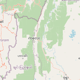
Map view of Phawngpui National Park

Use this park location map to pinpoint Phawngpui National Park in India, understand its exact geographic position, and read its mapped placement within the surrounding landscape more clearly.

Pigeon | © OpenStreetMap contributors

Location context for Phawngpui National Park

Mizoram
Park atlas

Trace the regional park geography, compare adjacent protected landscapes, and expand your exploration in Northeast India.

Explore Other National Parks and Protected Areas Near Phawngpui National Park
Continue your geographic exploration beyond Phawngpui National Park by browsing additional national parks and protected areas across Northeast India and surrounding conservation landscapes. Compare diverse montane ecosystems, cloud forests, and wildlife habitats to gain deeper insight into their regional geography.
National parkRangamati District

Kaptai National Park: Protected Landscape and Geographic Context in Rangamati District

Explore its mixed evergreen forest and lakeside terrain.

Kaptai National Park is a crucial protected area located in Bangladesh's Rangamati District, renowned for its mixed evergreen forests and unique position adjacent to Kaptai Lake. This detail page provides an atlas-oriented perspective on the park's geographic identity, mapped boundaries, and its role within the diverse Chittagong Hill Tracts region. Understand the terrain, from rolling hills to lakeside environments, and appreciate its conservation significance as a national park.

Area
54.64 km²
Established
1999
IUCN
II
Climate
Subtropical
National parkChamphai

Murlen National Park: Mapped Protected Landscape and Regional Geographic Context

National Park discovery in Champhai, India.

Delve into the specifics of Murlen National Park, a key protected area situated in the Champhai region. This entry focuses on its identity as a National Park, providing critical information about its geographic placement and mapped boundaries. Understanding Murlen National Park within its regional landscape context is fundamental for comprehensive atlas-based exploration of India's protected areas.

Area
200 km²
Established
1991
IUCN
II
Relief
Mountain
National parkChittagong District

Baroiyadhala National Park: A Vital Wildlife Corridor and Protected Forest Landscape in Bangladesh

Discover its terrain, mapped boundaries, and regional significance.

Baroiyadhala National Park, situated in Bangladesh's Chittagong District, stands as a critical national park dedicated to preserving forest ecosystems and functioning as an essential wildlife corridor. The park's undulating terrain and dense vegetation are vital for supporting threatened species and maintaining habitat connectivity. This page offers an atlas-style exploration of Baroiyadhala National Park, detailing its protected area status, geographic context within the Chittagong region, and its significance for conservation in South Asia, providing a rich understanding of its natural landscape.

Area
29.34 km²
Established
2010
IUCN
II
Climate
Tropical
National parkCox's Bazar District

Medhakachhapia National Park: Protected Mangrove Landscape and Geography in Cox's Bazar

Mapping the boundaries of a unique coastal Bangladesh National Park.

Medhakachhapia National Park is a distinct protected area in Cox's Bazar District, Bangladesh, renowned for its old-growth Rhizophora apiculata mangrove forest. Spanning approximately 396 hectares, it serves as a crucial habitat and represents a specific type of tropical coastal landscape. This park's designation as a national park highlights its conservation importance, particularly its role in protecting some of Bangladesh's most mature mangrove stands. Explore its geographic context and protected status for a deeper understanding of its natural landscape.

Area
3.959 km²
Established
2008
IUCN
IV
Relief
Lowland
National parkSagaing Region

Alaungdaw Kathapa National Park: National Park with Mapped Boundaries in Sagaing Region

Explore its protected landscape and regional geography.

Alaungdaw Kathapa National Park is a protected natural area situated in Myanmar's Sagaing Region. This national park is defined by its specific geographic boundaries and serves as a key component within the regional landscape atlas. Its designation highlights its importance for conservation and offers insights into the natural terrain and protected area distribution, providing a focused entry for geographic study.

Area
1,403 km²
Established
1989
IUCN
II
Relief
Mountain
National parkChin State

Natmataung National Park: Protected Mountain Landscape and Biodiversity Atlas in Chin State

Explore the mapped terrain and elevational gradients of Mount Victoria.

Natmataung National Park, located in Chin State, Myanmar, offers a profound encounter with dramatic mountainous terrain and exceptional biodiversity. As a protected national park, it safeguards Mount Victoria, the highest peak in the region, and a remarkable ecological gradient spanning diverse forest types. This page provides an atlas-focused view of its geography, highlighting the steep ridgelines, deep valleys, and unique habitats that define this significant protected landscape and its role in watershed protection.

Area
723 km²
Established
2010
IUCN
II
Relief
Mountain
National parkBangladesh

Himchari National Park: A Protected National Park within Bangladesh's Delta Geography

Mapped protected area and landscape context in South Asia.

Himchari National Park represents a vital protected natural area contributing to the rich geography of Bangladesh. As a national park, it offers users a focal point for understanding mapped landscapes and the distribution of conservation lands within the South Asian delta region. Exploring this entity provides insight into the country's protected areas and their unique environmental settings for structured atlas discovery.

Area
17.29 km²
Established
1980
IUCN
IV
Relief
Upland
National parkTripura

Clouded Leopard National Park: National Park Protected Area in Tripura's Forested Landscape

Mapped primate habitat and regional geography in Northeast India.

Clouded Leopard National Park serves as a critical protected area within Tripura, India, focusing on the conservation of its forest ecosystems and primate populations, including the Phayre's langur. As part of the larger Sepahijala Wildlife Sanctuary, its mapped boundaries contribute to the regional protected landscape. This national park offers valuable insight into the natural terrain and biodiversity specific to Northeast India, providing a unique geographic focus for atlas exploration.

Area
5.08 km²
Established
2007
IUCN
II
Climate
Tropical

Common questions about visiting, size, designation, and location context for Phawngpui National Park

Phawngpui National Park FAQs for park facts, access, geography, and protected area context
Find quick answers about Phawngpui National Park, including protected-area facts, park geography, trail and visitor context, and how the park fits into its surrounding country and regional landscape.
MoriAtlas Explorer

Continue Your Protected Areas Search Across the Global Atlas

Deepen your exploration by continuing the structured search for national parks and protected areas worldwide. Utilize the comprehensive filtering capabilities to compare different conservation landscapes and refine your understanding of global park geography. Discover more about the distribution and characteristics of protected natural areas.

Global natural geography
