

Mori Atlas logo
Wildlife reservePhibsoo Wildlife Sanctuary

Discover the mapped natural terrain and wildlife reserve boundaries of Phibsoo Wildlife Sanctuary.

Phibsoo Wildlife Sanctuary: Bhutan's Protected Landscape and Regional Geography

Phibsoo Wildlife Sanctuary stands as a significant protected area within Bhutan, contributing to the nation's commitment to conservation in the Eastern Himalayas. This entry provides an atlas-focused perspective on the sanctuary, detailing its role as a wildlife reserve and its place within the country's distinctive geography. Users can explore the mapped landscape context and understand the geographic significance of Phibsoo Wildlife Sanctuary as a protected natural area.

Wildlife SanctuarySal ForestsChital DeerElephant HabitatTiger RangeBiological Corridor

Phibsoo Wildlife Sanctuary

Wildlife reserve

Park overview

Structured park overview, official facts, and landscape profile for Phibsoo Wildlife Sanctuary

Phibsoo Wildlife Sanctuary park facts, protected area profile, and essential visitor context

Review the core facts for Phibsoo Wildlife Sanctuary, including designation, size, terrain, visitor scale, habitats, and operating context in one park-focused overview.

About Phibsoo Wildlife Sanctuary

Phibsoo Wildlife Sanctuary represents a distinctive element within Bhutan's extensive network of protected areas, which together cover a remarkable proportion of the country's territory. Established in 2009 following a period of internal instability during the 1990s, the sanctuary has been recovering from historical impacts while gradually restoring its ecological integrity. The protected area occupies a transitional zone between the more extensive lowland forests of Royal Manas National Park to the east and the montane ecosystems of the Himalayas to the north.

The sanctuary's location along the border with West Bengal places it at the interface between Himalayan and Gangetic plain ecosystems, creating a unique confluence of species from different biogeographic regions. The biological corridor connecting Phibsoo to neighboring protected areas allows for seasonal movement of large mammals, maintaining genetic connectivity across the broader landscape. This connectivity is particularly important for species such as elephants and tigers that require large home ranges.

The absence of human settlements within the sanctuary boundaries distinguishes Phibsoo from many other protected areas in South Asia, where human-wildlife conflict and resource extraction pressure can significantly impact ecological processes. This relatively untouched character has allowed the sanctuary to maintain more intact ecological communities, particularly in the lower elevation zones where agricultural expansion has transformed much of the surrounding landscape.

Quick facts and research context for Phibsoo Wildlife Sanctuary

Phibsoo Wildlife Sanctuary covers 268.93 square kilometers in western Bhutan, making it the country's second-smallest protected area. The sanctuary spans elevations from 200 to 1,600 meters and is located in both Sarpang and Dagana Districts. It connects to two major national parks via a biological corridor and is bounded by the Sunkosh and Sanathang Rivers. The sanctuary has no permanent human residents.

Protection and recognition

Verifying the terrestrial boundaries, management scope, and official designation records of the sanctuary

Phibsoo Wildlife Sanctuary Protection Status and Conservation Designation

Phibsoo Wildlife Sanctuary features a dedicated terrestrial protection scope designed to preserve its local ecosystem within the regional network of protected areas. Evaluating verified boundary records and official designation datasets provides essential geographic context for analyzing global conservation frameworks.

Protection details

Protection scope
Terrestrial
Transboundary protection
No
Park context

Deeper park guide and search-rich context for Phibsoo Wildlife Sanctuary

Phibsoo Wildlife Sanctuary history, landscape, wildlife, and travel context

Explore Phibsoo Wildlife Sanctuary through its history, landscape character, ecosystems, wildlife, conservation priorities, cultural context, and seasonal travel timing in a structured park guide built for atlas discovery and search intent.

Why Phibsoo Wildlife Sanctuary stands out

Phibsoo Wildlife Sanctuary holds a unique position in Bhutan's protected area system as the only place in the country where chital, also known as spotted deer, occurs in significant numbers within natural forest habitat. The sanctuary also preserves one of the few remaining stands of natural sal forests in Bhutan, a tree species of significant ecological and economic importance across South Asia. This combination of habitat types supports an impressive array of large mammal species, making Phibsoo one of the more biodiverse protected areas relative to its size in the region.
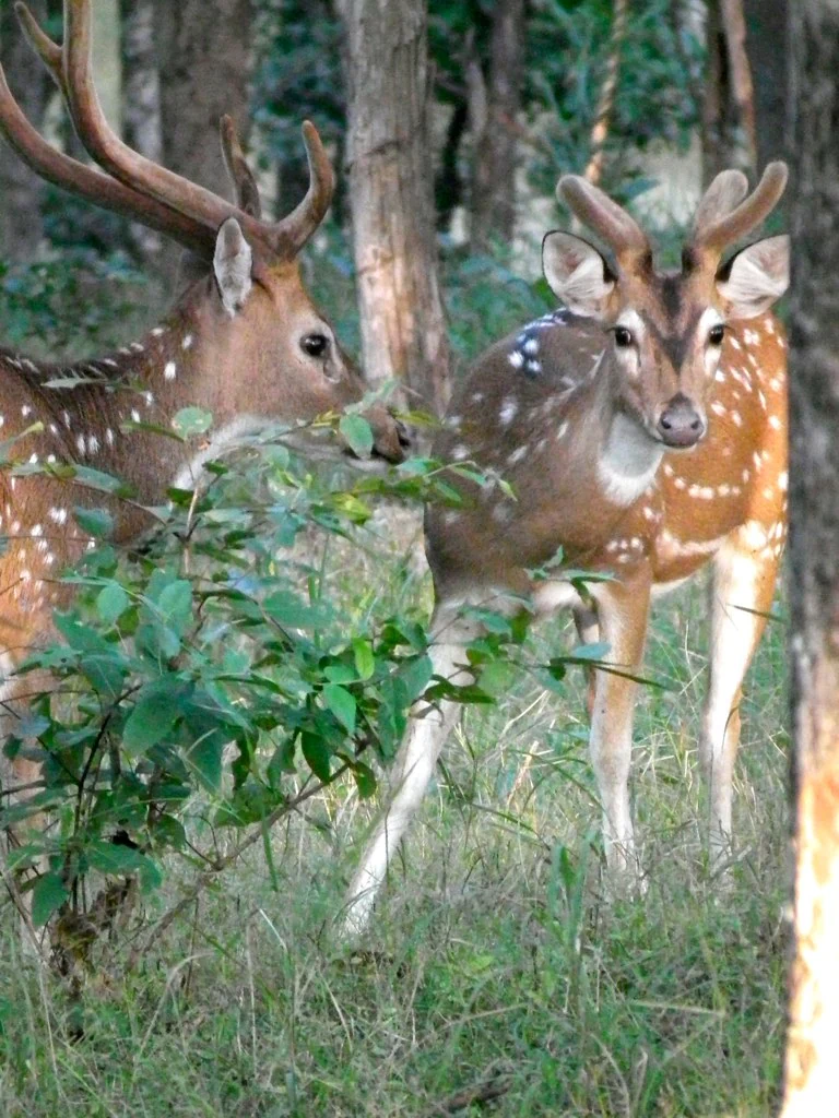
Two chital stags with white spots and velvet antlers standing among green vegetation and trees
Two chital stags with velvet antlers in the forested area of Phibsoo Wildlife Sanctuary

Phibsoo Wildlife Sanctuary history and protected-area timeline

Phibsoo Wildlife Sanctuary was formally established in 2009, making it one of Bhutan's more recently designated protected areas. The sanctuary's late establishment compared to other parks in Bhutan reflects the complex internal circumstances the country faced during the 1990s, when political instability and militia activity delayed the full development of protected area infrastructure in certain regions. The delay ultimately allowed the land to remain relatively undisturbed, contributing to the ecological value the sanctuary now holds.

The establishment of Phibsoo was part of a broader expansion of Bhutan's conservation network, which has sought to protect representative samples of all major ecosystem types within the country. Bhutan's commitment to maintaining at least 60% of its land area under forest cover has provided the policy framework within which protected areas like Phibsoo have been created and maintained. The biological corridor system, which connects Phibsoo to neighboring parks, reflects the country's integrated approach to landscape-level conservation rather than treating protected areas as isolated islands.

Phibsoo Wildlife Sanctuary landscape and geographic character

The terrain within Phibsoo Wildlife Sanctuary spans an elevation gradient of approximately 1,400 meters, from 200 meters near the river valleys to 1,600 meters in the higher sections. This topographic variation creates distinct landscape character across the sanctuary, with lower slopes and valley floors dominated by broadleaf deciduous forest, while higher elevations support mixed forest communities with coniferous elements. The sanctuary lies within the Himalayan foothills, with terrain that is generally steep and dissected by numerous small streams and drainages.

The Sunkosh River and Sanathang River form the western and eastern boundaries of the sanctuary respectively, creating natural barriers that separate the protected area from the international border with India. These river systems have carved steep-sided valleys through the landscape, creating diverse microhabitats and exposing geological formations that contribute to the visual character of the terrain. The forest cover is generally dense, particularly in the less accessible areas, creating a largely continuous canopy across most of the sanctuary.

Phibsoo Wildlife Sanctuary ecosystems, habitats, and plant life

The ecological significance of Phibsoo Wildlife Sanctuary is anchored in its combination of sal-dominated forests and the presence of species more typical of lower latitudes. The natural sal forests within the sanctuary represent a rare example of this forest type in Bhutan, as extensive areas of sal forest in the Himalayan region have been converted to agriculture or degraded by human use. Sal (Shorea robusta) is a commercially important timber species that forms extensive pure stands in suitable habitat, creating a distinctive forest structure with a relatively open understory.

The sanctuary's position at a relatively low elevation within Bhutan, combined with its protection from human disturbance, has allowed it to maintain ecological communities that would be difficult to preserve in more accessible locations. The forest structure supports complex food webs and provides habitat for numerous species of birds, insects, and smaller mammals that depend on specific forest types. The seasonal dynamics of these ecosystems, influenced by monsoon patterns and the dry winter period, create natural variation in vegetation structure and wildlife activity patterns throughout the year.

Phibsoo Wildlife Sanctuary wildlife and species highlights

Phibsoo Wildlife Sanctuary supports a remarkable concentration of large mammal species relative to its size. The sanctuary is unique in Bhutan for its population of chital (Axis axis), also known as spotted deer, which thrives in the sal forest environment. These deer are more commonly associated with the forests of the Indian subcontinent, making their presence in Bhutan a notable ecological feature. The sanctuary also supports populations of Asian elephants (Elephas maximus), Bengal tigers (Panthera tigris tigris), and gaur (Bos gaurus), three of the largest and most charismatic mammal species in the region.

The aquatic environments within and adjacent to the sanctuary support several species of mahseer (Tor species), a group of large cyprinid fish that are important both ecologically and as indicators of river health. Perhaps most significantly, the sanctuary may harbor populations of the South Asian river dolphin (Platanista gangetica), a highly specialized cetacean that inhabits major river systems. If confirmed, this would represent an important population of this endangered species within Bhutan. The combination of forest-dwelling ungulates, large predators, and riverine species creates a diverse wildlife community.

Phibsoo Wildlife Sanctuary conservation status and protection priorities

Phibsoo Wildlife Sanctuary contributes to Bhutan's remarkable achievement of maintaining extensive forest cover and protected areas. The sanctuary's role in connecting larger protected areas through the biological corridor system enhances conservation outcomes at a landscape scale, allowing species to move between protected zones and maintaining genetic diversity in populations that might otherwise become isolated. This corridor-based approach recognizes that effective conservation requires more than isolated protected islands.

The presence of species such as the gaur, which is listed as vulnerable on the IUCN Red List, and the potential for river dolphin populations, elevates the conservation significance of the sanctuary beyond its relatively small size. The protection of natural sal forests also contributes to carbon sequestration and watershed protection, providing ecosystem services that extend beyond biodiversity conservation. The sanctuary's recovery from the impacts of the 1990s demonstrates the resilience of natural ecosystems when given protection and time to regenerate.

Phibsoo Wildlife Sanctuary cultural meaning and human context

Phibsoo Wildlife Sanctuary does not contain permanent human settlements, which limits the direct cultural heritage dimension of the area. The surrounding landscape in Sarpang and Dagana Districts includes rural communities that practice agriculture and livestock husbandry, with traditional patterns of land use that have shaped the broader landscape over generations. The sanctuary's establishment in 2009 reflects more recent approaches to conservation that prioritize ecological integrity over human settlement within core protected zones.

The absence of human residents within the sanctuary boundaries is notable in the South Asian context, where many protected areas continue to face pressures from traditional resource use and grazing. This characteristic allows ecological processes to function with minimal interruption from human activities, though it also means that the cultural dimension of the sanctuary is limited compared to areas with longer histories of human interaction with the landscape.

Top sights and standout views in Phibsoo Wildlife Sanctuary

Phibsoo Wildlife Sanctuary offers a distinctive combination of features that set it apart within Bhutan's protected area network. The opportunity to observe chital deer in their natural forest habitat, combined with the potential for encountering elephants and tigers, makes the sanctuary appealing for wildlife enthusiasts. The natural sal forests represent a relatively rare habitat type in Bhutan and provide a backdrop for exploration that differs from the higher-elevation coniferous and rhododendron forests more commonly associated with the Himalayas.

The sanctuary's compact size and lack of human residents create conditions that are relatively unusual for protected areas in South Asia, offering a more intimate wilderness experience than larger parks that may experience higher visitor pressure. The connection to the broader biological corridor network also means that wildlife viewing may be influenced by seasonal movements across the landscape.

Best time to visit Phibsoo Wildlife Sanctuary

The most favorable period for visiting Phibsoo Wildlife Sanctuary typically spans from November through March, when weather conditions are generally more stable and wildlife viewing opportunities are enhanced as animals congregate around remaining water sources. The post-monsoon period brings clearer skies and reduced vegetation density in lower elevations, improving visibility for wildlife observation. The winter months offer comfortable temperatures for walking in the lower terrain, though higher elevations may experience cooler conditions.

The monsoon season from June through September brings heavy rainfall to the region, which can make some trails difficult and may limit accessibility in lower-elevation areas. During this period, the landscape becomes lush and rivers and streams flow strongly, but wildlife viewing becomes more challenging and some areas may be less accessible. The timing of visits should also consider the broader context of travel within Bhutan, as the country's mountainous terrain can be significantly affected by seasonal weather patterns.

Monthly climate preview

Analyzing thirty-year precipitation ranges and temperature trends in Bhutan

Phibsoo Wildlife Sanctuary Climate Normals and Monthly Weather Averages

Long-term climate data at a representative elevation of 1606 meters reveals a seasonal cycle with average temperatures ranging from eight degrees Celsius up to twenty-one degrees Celsius alongside highly variable precipitation. Detailed monthly metrics map these transitions to clarify wet-dry variations and temperature thresholds across the calendar.
Annual mean16 °C
8 °C21 °C
Jan
Feb10°
Mar13°
Apr17°
May19°
Jun21°
Jul21°
Aug21°
Sep20°
Oct17°
Nov13°
Dec10°
Warmest month
July

21.1 °C

Coolest month
January

8.1 °C

Wettest month
July

10.6 mm/day

Driest month
December

0.1 mm/day

Park location guide

Geography guide, regional context, and park location map for Phibsoo Wildlife Sanctuary

Phibsoo Wildlife Sanctuary park geography, regions, and map view in Bhutan

Understand where Phibsoo Wildlife Sanctuary sits in Bhutan through a broader geographic reading of the surrounding landscape, nearby location context, and its mapped position within the national park landscape.

How Phibsoo Wildlife Sanctuary fits into Bhutan

Bhutan, officially the Kingdom of Bhutan, is a landlocked country in South Asia situated in the Eastern Himalayas. With a population of approximately 727,000 and an area of 38,394 km², it is a constitutional monarchy ruled by the Wangchuck dynasty. The country is known for its Gross National Happiness philosophy, pristine mountain landscapes, and commitment to preserving its Buddhist culture.

Wider geography shaping Phibsoo Wildlife Sanctuary in Bhutan

Bhutan is located in the Eastern Himalayas in South Asia, bordered by China to the north and northwest and India to the south and southeast. The country's terrain is predominantly mountainous with steep valleys, ranging from elevations around 100 meters in the southern foothills to peaks exceeding 7,000 meters in the northern highlands. The major river systems flow southward from the Himalayas into India's Brahmaputra basin.

Map view of Phibsoo Wildlife Sanctuary

Use this park location map to pinpoint Phibsoo Wildlife Sanctuary in Bhutan, understand its exact geographic position, and read its mapped placement within the surrounding landscape more clearly.

Pigeon | © OpenStreetMap contributors

Location context for Phibsoo Wildlife Sanctuary

Sarpang District

Visually understand the dense forests, river valleys, and diverse environments that define Bhutan's unique conservation landscape.

Phibsoo Wildlife Sanctuary: Explore Landscapes, Habitats, and Terrain through Protected Area Imagery

Browse a visual atlas of Phibsoo Wildlife Sanctuary, showcasing its distinct lowland forests, riverine habitats, and varying elevations. These park images provide essential insight into the ecological character and scenic beauty that supports rare chital deer and other significant wildlife in Bhutan. Understanding the terrain and environment through photography enhances appreciation for this vital protected area.

Two chital stags with white spots and velvet antlers standing among green vegetation and trees

Park atlas

Compare regional park geography and connected protected landscapes surrounding Phibsoo Wildlife Sanctuary, extending your discovery.

Explore Protected Areas and National Parks Near Phibsoo Wildlife Sanctuary, Bhutan

Browse additional protected areas and national parks surrounding Phibsoo Wildlife Sanctuary, tracing their unique geographies and ecological connections within Bhutan's complex terrain. Understand the regional spread of conservation efforts, comparing diverse habitats, elevation gradients, and the distribution of key species across the broader landscape.
National parkKokrajhar District
About 17 km away#1 closest

Southwest

Raimona National Park: National Park Protected Landscape and Geographic Atlas Exploration

Discover mapped terrain and regional geography within Raimona National Park.

Raimona National Park, designated as a national park within India's Kokrajhar District, offers rich opportunities for atlas-based geographic discovery. This page details the park's protected landscape, providing insights into its mapped boundaries and the surrounding natural terrain. Understanding Raimona National Park's placement within the regional geography allows for a deeper appreciation of its role as a significant protected area, perfect for detailed map exploration and landscape context.

Area
422 km²
Established
2021
IUCN
II
Relief
Mountain
National parkAssam
About 27 km away#2 closest

East

Sikhna Jwhwlao National Park: Atlas Mapping of Assam's Indo-Bhutan Frontier Landscapes

Protected corridors and sub-Himalayan forest terrain

Sikhna Jwhwlao National Park provides a vital link between four neighbouring protected areas in the Bodoland region. The park landscape features a complex mosaic of riverine corridors and moist deciduous forests that anchor wildlife movement near the Indo-Bhutan frontier. Beyond its role as a flagship habitat for primates and rhinoceros, the park contains significant cultural heritage sites tied to Bodo history within its distinct sub-Himalayan topography.

Area
316.29 km²
Established
2025
IUCN
II
Relief
Lowland
National parkAlipurduar district
About 49 km away#3 closest

West

Buxa Tiger Reserve National Park: Protected Landscape Exploration in Alipurduar District

Mapped boundaries and diverse ecosystems within India's easternmost tiger reserve.

Buxa Tiger Reserve, a designated national park in India's Alipurduar district, offers a profound look into a protected landscape at the crossroads of major biogeographic zones. Its terrain ascends from the Gangetic Plains to the Himalayan foothills, showcasing a rich tapestry of forest types and supporting significant faunal diversity. This reserve functions as a crucial international elephant corridor, facilitating wildlife movement between India and Bhutan, and stands as a testament to the importance of mapped protected areas in transboundary conservation efforts.

Area
760 km²
Established
1983
IUCN
II
Relief
Mixed relief
Wildlife reserveAssam
About 58 km away#4 closest

Southeast

Chakrashila Wildlife Sanctuary: Geography, Mapped Terrain, and Assam Protected Landscapes

A vital wildlife reserve within the Brahmaputra foothills

Chakrashila Wildlife Sanctuary represents a key ecological link in western Assam, characterized by its mix of sal-dominated hill forests and two significant freshwater wetlands, Dheer Beel and Diplai Beel. This compact reserve offers a distinct topographical study of the Brahmaputra foothills and remains a central point for understanding primate-focused habitat preservation in the region.

Area
45.568 km²
Established
1994
IUCN
IV
Water
Major water bodies
National parkTrongsa District
About 63 km away#5 closest

Northeast

Jigme Singye Wangchuck National Park: Bhutan National Park's Geographic and Landscape Atlas

Mapped protected area within Trongsa District's natural terrain.

Delve into the detailed geographic identity of Jigme Singye Wangchuck National Park, a protected national park situated in Bhutan's Trongsa District. This park provides essential context for understanding Bhutanese geography and conservation landscapes. Examine its mapped boundaries and place within the regional terrain, offering a structured exploration for anyone interested in national park geography and protected natural areas.

Area
1,730 km²
Established
1995
IUCN
II
Relief
Mountain
National parkBhutan
About 72 km away#6 closest

East

Royal Manas National Park: Bhutan's Premier Protected Area and Oldest National Park

Explore the mapped terrain and diverse ecosystems of this landmark Bhutanese conservation area.

Royal Manas National Park, Bhutan's first national park established in 1966, serves as a critical conservation hub in the Eastern Himalayas. Spanning over 1,057 square kilometers, it protects a vast array of landscapes, from lowland tropical forests to permanent ice fields. Its designation as the kingdom's conservation showpiece and its role in transboundary protection underscore its immense geographic and ecological importance within Bhutan.

Area
1,057 km²
Established
1966
IUCN
II
Relief
Mountain
National parkAlipurduar district
About 77 km away#7 closest

West

Jaldapara National Park: India's Premier Grassland and Rhino Conservation Landscape

Explore mapped boundaries and savanna terrain in Alipurduar district.

Jaldapara National Park is a protected national park in India's Alipurduar district, celebrated for its expansive rolling grasslands and significant population of Indian one-horned rhinoceros. This protected area showcases a distinctive savanna landscape, an unusual feature among Indian national parks, interspersed with riverine forests. Its elevation of 61 meters above sea level positions it at the edge of the Eastern Himalayas, offering a unique geographic setting for understanding regional biodiversity and conservation efforts.

Area
216.51 km²
Established
1941
IUCN
II
Relief
Lowland
Wildlife reserveBhutan
About 87 km away#8 closest

Northwest

Motithang Takin Preserve: Bhutan Wildlife Reserve with Unique Protected Landscape Context

Explore the mapped geography and national animal sanctuary.

The Motithang Takin Preserve offers a unique glimpse into Bhutan's dedication to its national animal, the takin. This wildlife reserve, located near the capital city, provides a defined protected area where the distinctive goat-antelope thrives. By examining the preserve's mapped boundaries and its forested terrain, users gain insight into Bhutan's approach to conservation and the cultural significance of this iconic species within the Himalayan landscape.

Area
0.034 km²
IUCN
IV
Relief
Upland
Climate
Temperate

Common questions about visiting, size, designation, and location context for Phibsoo Wildlife Sanctuary

Phibsoo Wildlife Sanctuary FAQs for park facts, access, geography, and protected area context

Find quick answers about Phibsoo Wildlife Sanctuary, including protected-area facts, park geography, trail and visitor context, and how the park fits into its surrounding country and regional landscape.
MoriAtlas Explorer

Continue Your Protected Areas Search Across the Global Atlas

Deepen your exploration by continuing the structured search for national parks and protected areas worldwide. Utilize the comprehensive filtering capabilities to compare different conservation landscapes and refine your understanding of global park geography. Discover more about the distribution and characteristics of protected natural areas.

Global natural geography