
Cave entrances
Park geography
Structured data on regional distribution, terrain elevation, and park landscape features
Geographic Profile and Mapped Boundaries of Phong Nha–Kẻ Bàng National Park in Vietnam
This geographic profile details the physical parameters of Phong Nha–Kẻ Bàng National Park, covering its 857.54 square kilometer area and mountainous karst terrain. Examine the recorded elevation reaching 1213 meters and identify the diverse environmental features including extensive tropical forest cover, rivers, and internal cave systems.

Vietnam's UNESCO-listed karst wilderness home to the world's largest cave
Phong Nha, Kẻ Bàng National Park
Phong Nha–Kẻ Bàng National Park is a UNESCO World Heritage Site in central Vietnam protecting one of the world's most significant karst landscapes. Located in Quảng Trị Province along the Annamite Range, approximately 500 kilometers south of Hanoi, the park encompasses dramatic limestone mountains reaching heights over 1,200 meters, traversed by the Sơn River and its extensive underground cave systems. The park was established in 2001 and inscribed on the UNESCO World Heritage List in 2003 for its outstanding geological values, with a second recognition in 2015 for its exceptional biodiversity. The protected area covers over 857 square kilometers of core zone with a larger buffer zone extending into Laos, forming a transnational conservation landscape of global importance. The park is renowned for its cave systems totaling approximately 300 documented caves and grottoes, including the world's largest known cave, and for supporting significant populations of endangered primates and other rare species within its pristine tropical forests.
- Location
- Vietnam
- Park type
- National park
- Established
- 2001
- Area
- 857.5 km²
- Highest point
- 1,213 m
Location overview
Regional administrative positioning and transboundary park status
Geographic Positioning of Phong Nha-Ke Bang National Park
Phong Nha-Ke Bang National Park spans Vietnam, American Samoa, and Quảng Bình Province. Its transboundary status highlights its regional positioning within the North Central Coast administrative zone.
- Countries
- Vietnam
- Regions
- North Central Coast, Quảng Bình Province
- Primary location
- Vietnam
- Geographic setting
- Transboundary · Inland
Boundary and coordinates
Interactive boundary geometry and calculated area metrics
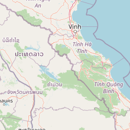
Phong Nha–Kẻ Bàng National Park Boundary Map and Spatial Extent
The mapped outline provides spatial context for the protected area across the region. Accompanying facts detail the recorded surface area, coordinate limits, and geographic spans without claiming legal survey precision.
- Boundary area
- 1,194 km²
- Boundary perimeter
- 241 km
- Northernmost point
- 17.739° N
- Southernmost point
- 17.3713° N
- Easternmost point
- 106.3905° E
- Westernmost point
- 105.7815° E
- Geographic centre
- 17.5326° N, 106.1111° E
- North–south span
- 40.7 km
- East–west span
- 64.7 km
Elevation and terrain
Mountain terrain profiles and recorded physical feature inventories
Phong Nha–Kẻ Bàng National Park Elevation Range and Mountain Terrain Geography
Recorded park metrics establish a maximum elevation of 1213 meters across the mountain terrain. Linked feature cards supply names, types, and spatial relationships for recorded natural formations.
- Maximum elevation
- 1,213 m
- Highest point
- 1,213 m
Selected named natural features
Cave entrances
Paradise Cave
Cave entrances
Hố Sụt 2 Hang Sơn Đoòng
Cave entrances
Tra Ang Cave (Approximate)
Cave entrances
Tiger Cave - Entrance 4
Cave entrances
Hang Tối
Environmental setting
Tropical mountain relief, major forest cover, and interconnected cave river systems
Phong Nha–Kẻ Bàng National Park Environmental Settings and Karst Classifications
Recorded landscape features and habitat types outline the tropical mountain relief and extensive forest cover defining the protected terrain. Stored categories link specific environmental classifications directly to relevant atlas destinations where available.
- Relief
- Mountain
- Climate
- Tropical
- Water
- Major water bodies
- Forest cover
- Mostly forested
- Seasonality
- Year-round
Landscape features
Mountains · Karst · Forest · Rivers · Waterfalls · Cave · Cliffs
Habitat types
Tropical forest · Montane forest · Karst habitat · Riverine habitat · Wetland
Park atlas
Compare regional conservation landscapes and trace the spread of protected terrain across Central Vietnam and its borders.
Discover Other National Parks and Protected Areas Near Phong Nha–Kẻ Bàng National Park
Continue your exploration from Phong Nha–Kẻ Bàng National Park by browsing other national parks and protected areas across Central Vietnam and its adjacent transboundary landscapes. Trace the regional distribution of conservation efforts and compare diverse protected terrain, from limestone mountains to vital forest reserves, for broader geographic understanding.
Protected areaSavannakhet Province
About 72 km away#1 closest
Southwest

Phou Xang He National Protected Area: Geographic Overview and Forest Landscape Mapping
Protected forest ecosystems in Savannakhet Province, Laos
Phou Xang He National Protected Area encompasses a vast, relatively undisturbed forest expanse in central Laos. This detailed look at the park's physical geography highlights its characteristic mix of deciduous and evergreen woodlands, serving as a vital habitat within the Annamite foothills region. Understand the spatial distribution of this protected landscape and its regional importance to conservation efforts across Savannakhet Province.
- Area
- 1,180 km²
- Established
- 1993
- IUCN
- VI
- Access
- Access unknown
National parkHà Tĩnh Province
About 75 km away#2 closest
Northwest

Vũ Quang National Park: Protected Landscape Identity and Geographic Context in Hà Tĩnh
National Park Discovery and Mapped Terrain Exploration
Investigate Vũ Quang National Park, a key protected area situated in Hà Tĩnh Province. This page provides detailed insight into the park's designation as a national park, focusing on its mapped boundaries, surrounding natural landscapes, and contribution to the regional geography. It serves as a vital resource for understanding the park's protected landscape characteristics and its place within Vietnam's atlas of conservation areas.
- Area
- 550.28 km²
- Established
- 2002
- IUCN
- II
- Relief
- Mountain
Wildlife reserveKhammouane Province
About 106 km away#3 closest
West
Phou Hin Poun National Biodiversity Conservation Area: Khammouane Province Landscapes
Tower karst geology and Annamite Range biodiversity
Delve into the geography of Phou Hin Poun National Biodiversity Conservation Area, where dramatic stone ridges and dense forest patches define a unique karst ecosystem. Located in Khammouane Province, this wildlife reserve stands as a major center for scientific discovery and protected habitat monitoring in central Laos.
- Area
- 1,801.49 km²
- Established
- 1993
- IUCN
- VI
- Relief
- Mountain
National parkMukdahan Province
About 175 km away#4 closest
Southwest

Phu Pha Thoep National Park: Mukdahan Province Protected National Park Geography
Explore its mapped protected landscape and regional context.
Phu Pha Thoep National Park is a designated national park in Thailand's Mukdahan Province, offering a distinct focus for geographic exploration. This resource provides detailed insights into its protected landscape, outlining mapped park boundaries and its integration within the regional geography. Understand the park's specific natural terrain and its value for structured atlas-style discovery, moving beyond simple location data to grasp its protected area significance.
- Area
- 48 km²
- IUCN
- II
- Visitors
- 47.6K annual
- Relief
- Upland
Protected areaBolikhamsai Province
About 181 km away#5 closest
Northwest
Nam Kading National Protected Area: An Atlas of Rugged Terrain in Bolikhamsai Province
River-carved mountain ranges and forest corridors
Nam Kading National Protected Area encompasses a vast, roadless wilderness in central Laos shaped by the Nam Kading river system. This protected landscape features deep valleys, dense evergreen forests, and dramatic relief that support a wide array of fauna and significant environmental research in the Bolikhamsai region.
- Area
- 1,690 km²
- Established
- 1993
- IUCN
- VI
- Relief
- Mountain
National parkNghệ An Province
About 184 km away#6 closest
Northwest
Pù Mát National Park: National Park Protected Landscape and Geographic Mapping
Explore Nghệ An Province's protected area context.
Pù Mát National Park is a key protected area situated in Nghệ An Province, Vietnam. This entry focuses on its role as a national park, detailing its mapped boundaries and geographic features. It serves as a vital point for understanding the distribution of protected lands and the natural landscape context within the broader regional atlas. Discover the specific geographic identity and atlas significance of Pù Mát National Park.
- Area
- 911.13 km²
- Established
- 2001
- IUCN
- II
- Relief
- Mountain
National parkAmnat Charoen Province
About 188 km away#7 closest
Southwest
Phu Sa Dok Bua National Park: National Park with Mapped Protected Boundaries
Explore protected landscapes in Amnat Charoen Province, Thailand.
Discover Phu Sa Dok Bua National Park, a designated national park situated within the geographic context of Amnat Charoen Province. This profile focuses on the park's protected area identity and its mapped boundaries, offering essential geographic information for atlas-based exploration and understanding its role within Thailand's conservation landscape.
- Area
- 231 km²
- Established
- 1992
- IUCN
- II
- Visitors
- 1.8K annual
National parkVietnam
191 km away#8 closest
Southeast
Bach Ma National Park: Protected Area and Mountain Landscape in Vietnam
Explore the biodiversity and unique geography of this vital national park.
Bach Ma National Park in Vietnam is a protected area defined by its steep, granite-rich mountainous terrain within the Annamite Range. The park’s location at a significant biogeographical crossroads contributes to its exceptional biodiversity, particularly its documented birdlife and varied forest ecosystems. Understanding Bach Ma National Park through its mapped landscape provides critical insight into Vietnam's natural heritage and the ecological dynamics shaped by its unique regional geography.
- Area
- 220 km²
- Established
- 1986
- IUCN
- II
- Relief
- Mountain
MoriAtlas Explorer
Continue Exploring Phong Nha–Kẻ Bàng National Park's Protected Landscape Atlas
Delve deeper into the mapped geography and unique karst features of Phong Nha–Kẻ Bàng National Park. Understand its place within Vietnam's protected areas and discover the geological context that makes this UNESCO World Heritage site a landmark for natural exploration.
Browse next
Global natural geography
Explore related park routes
Explore MoriAtlas Global ParksBrowse All MoriAtlas ParksGlobal Park Map DiscoveryMoriAtlas: Browse All CountriesBrowse All MoriAtlas ContinentsNational Park Environment AtlasGrand Canyon National Park AtlasYellowstone National Park AtlasYosemite National Park Atlas and GeographySerengeti National Park AtlasGalápagos National Park Protected LandscapeBanff National Park Geography and AtlasKruger National Park Atlas EntryUluṟu-Kata Tjuṯa National Park AtlasExplore Uluru-Kata Tjuta National Park GeographyPlitvice Lakes National Park AtlasFiordland National Park Protected LandscapeGreat Smoky Mountains National Park AtlasAfghanistan National Parks and Protected AreasAlbania National Parks and Protected AreasAlgeria National Parks and Protected AreasAmerican Samoa National Parks and Protected AreasAndorra National Parks and Protected AreasAngola National Parks and Protected AreasAntarctica National Parks and Protected AreasAntigua and Barbuda Park List