Why Phước Bình National Park stands out
Phước Bình National Park is best known for its exceptional biodiversity in the Southern Annamite Ecoregion, protecting significant populations of threatened large mammals and endemic bird species tied to the Da Lat Plateau. The park supports over 1,225 plant species and 327 animal species, including flagship mammals such as gaur, giant muntjac, black-shanked douc langur, and yellow-cheeked gibbon. The avifauna is particularly notable, with five of the eight restricted-range species that occur in the Da Lat Plateau Endemic Bird Area found within the park, including the endangered collared laughingthrush and the globally vulnerable pale-capped pigeon. The park also contains the Vietnam greenfinch, a near-threatened species endemic to the Da Lat plateau region.
Phước Bình National Park history and protected-area timeline
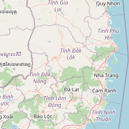
Phước Bình National Park was originally designated as a nature reserve under Decision 125/2002/QD on 26 September 2002. The area was elevated to national park status on 8 June 2006 under Decision number 822/QĐ-TTg, signed by then Vice Prime Minister Nguyễn Tấn Dũng. This transition reflected the area's recognized importance for biodiversity conservation and watershed protection within Vietnam's protected area system. The park contains historical significance from the Vietnam War period, notably the site of Pi Nang Tac's stone trap, a wartime battlefield where over 100 soldiers were killed in 1965 during guerrilla operations. The park's management falls under the People's Committee of Ninh Thuận Province, with the protected area organized into distinct zones including a strict protection zone of 10,766 hectares, a rehabilitation zone of 9,030 hectares, and an administrative and service area of 18 hectares, complemented by a buffer zone of 11,080 hectares surrounding the core protected area.
Phước Bình National Park landscape and geographic character
The terrain of Phước Bình National Park is characterized by steep mountainous topography in the western portion where peaks rise to approximately 2,200 meters above sea level, with elevation gradually decreasing eastward toward the coastal plains of south-central Vietnam. The landscape is dissected by three principal stream systems, Gia Nhông (also known as suối Ông), Đa Mây (sông Trương), and sông Hàm Leo, which carve valleys through the mountainous terrain. These streams function as the main watershed for the Cai River, the largest river in Ninh Thuận Province. The park spans the transition between the Đà Lạt plateau and the coastal lowlands, creating a diverse landscape of ridgelines, valley floors, and stream corridors. The forest cover varies with elevation, creating a patchwork of different forest types across the topographic gradient.
Phước Bình National Park ecosystems, habitats, and plant life
Phước Bình National Park is situated within the Southern Annamite Ecoregion, which is recognized as one of the four global ecoregions in southern Vietnam. The park includes the Southern Annamite Montane Rain Forests as a designated terrestrial ecoregion. The diversity of habitats supported by the park's topographic range includes lowland dry dipterocarp forests, wet evergreen forests, montane evergreen forests, and mixed broadleaf-tropical conifer forests. This habitat diversity, combined with the montane climate conditions in the higher elevations that remain cool and wet throughout most of the year, supports ecological communities with both tropical and temperate characteristics. The park's flora includes 75 species that are threatened at either global or national level, with 36 species listed in the Vietnam Red Book of Flora and 58 species included in the IUCN Red List. The conifer Pinus dalatensis occurs within the park, a species known from fewer than 10 distinct locations globally with populations typically limited to less than 100 mature trees each.
Phước Bình National Park wildlife and species highlights
The wildlife community of Phước Bình National Park is remarkably diverse, with 410 bird species and 122 mammal species documented for the broader southern rain forest region, of which 69 mammal species and 206 bird species are recorded within the park itself. The mammal community includes significant populations of large ungulates, with an estimated two herds of gaur totaling over 80 individuals. The park serves as important habitat for several threatened primate species including the black-shanked douc langur and yellow-cheeked gibbon, both classified as endangered on the IUCN Red List. The giant muntjac, an endangered species known only from the Annamite mountain range, is present in the park. Bird life is exceptionally rich, with the park supporting five of the eight restricted-range species in the Da Lat Plateau Endemic Bird Area, including two globally threatened species: the collared laughingthrush (endemic to the Da Lat plateau) and the crested argus. Additional notable species include the great hornbill, Vietnam greenfinch (endemic to the Da Lat plateau), spot-breasted laughingthrush, and the pale-capped pigeon, a globally vulnerable species for which this is one of only six Important Bird Areas in Vietnam.
Phước Bình National Park conservation status and protection priorities
Phước Bình National Park plays a critical role in biodiversity conservation as part of a contiguous protected area network linking with Bi Doup-Nui Ba National Park to form a large conservation landscape spanning the border between Ninh Thuận and Lâm Đồng provinces. The park is recognized as an Important Bird Area (IBA) supporting globally threatened species and endemic bird populations tied to the Da Lat Plateau. It provides essential watershed protection for the Cai River system, upon which the entire Ninh Thuận Province depends for water supply. Despite its protected status, the park faces significant conservation challenges. More than 75 percent of the natural habitat in the broader ecoregion has been converted or degraded, with remaining forest existing in small, isolated fragments. This habitat loss resulted primarily from long-term cultivation between 1976 and 2002 and the遗留 of chemical warfare. Ongoing threats include agricultural expansion, particularly coffee plantation development, wildlife poaching, and shifting cultivation practices in the upper slopes. Approximately 4,438 people from 876 households live in the buffer zone, predominantly from the Raglay minority group, with their livelihoods closely tied to forest resources.
Phước Bình National Park cultural meaning and human context
The Phước Bình National Park region is home to local communities, primarily the Raglay minority group who comprise approximately 74 percent of the buffer zone population, alongside Churu and Kinh communities. These ethnic groups have traditional connections to the landscape and depend on forest resources for their livelihoods, including agriculture, harvesting of non-timber forest products such as resin and medicinal plants, and in some cases, wildlife hunting. The park also contains historical cultural significance from the Vietnam War period, with the Pi Nang Tac stone trap representing a historic wartime battlefield. Ecotourism activities in the park offer opportunities for visitors to learn about the culture and lifestyle of these local communities.
Top sights and standout views in Phước Bình National Park
Phước Bình National Park offers a combination of high biodiversity value, scenic mountain landscapes, and cultural significance within Vietnam's protected area network. The park protects critical habitat for multiple endangered species including gaur, giant muntjac, black-shanked douc langur, and yellow-cheeked gibbon, as well as endemic birds such as the collared laughingthrush and Vietnam greenfinch. The montane forest landscapes with peaks reaching over 2,200 meters provide dramatic scenery and habitat diversity. The park's function as a watershed for the Cai River adds environmental service value to its biodiversity significance. Visitors can engage in hiking, rafting, swimming, and camping while experiencing the local Raglay culture.
Best time to visit Phước Bình National Park
The best time to visit Phước Bình National Park is during the dry season from December through April, when rainfall is minimal and trail conditions are most suitable for hiking and outdoor activities. The wet season occurs between May and late November, with September typically receiving the highest rainfall. Visitors during the wet season should be prepared for heavier precipitation and potentially more difficult trail conditions, particularly in the mountainous western portions of the park where annual rainfall can reach 2,000 millimeters.