
Mori Atlas logo
National parkPrespa National Park

Mapping the lake ecosystems, bird habitats, and forest terrain of the transboundary Prespa basin

Prespa National Park: A Deep Dive into the Wetland Geography and Protected Landscapes of Greece

(Ethnikos Drymos Prespon)

Prespa National Park serves as a critical wetland reserve located in the Western Macedonia region of northern Greece. This protected area centers on the expansive lake system of Small Prespa Lake, forming a transboundary conservation zone that supports dense reed beds and rare bird populations. The surrounding terrain of deciduous forests and open meadows provides a complex ecological framework that defines this unique Mediterranean highland landscape.

national parkwetlandsRamsar sitelake ecosystemwaterbirdspelican breeding
A flat-style digital illustration showing a tiered waterfall cascading down a cliffside into a river, surrounded by pine trees and distant mountains under a soft sun.

Prespa National Park

National park

Park overview

Structured park overview, official facts, and landscape profile for Prespa National Park

Prespa National Park park facts, protected area profile, and essential visitor context

Review the core facts for Prespa National Park, including designation, size, terrain, visitor scale, habitats, and operating context in one park-focused overview.

About Prespa National Park

Prespa National Park is a lake-centered protected area in the far north of Greece, capturing the Greek share of the Prespa basin. The park encompasses the southeastern arm of the larger Lake Prespa and the entire shoreline and watershed of Small Prespa Lake, where the water meets gentle hills cloaked in mixed broadleaf forest, pastureland, and traditional villages.

The park sits inside a wider transboundary conservation context. The Prespa lakes are shared between Greece, North Macedonia, and Albania, and the Greek park is part of a broader effort to maintain the ecological coherence of the basin. Within Greece, the protected zone ties together the lake, its islands, the inflowing streams, and the forested slopes that filter and feed the wetlands below.

Although relatively modest in size compared with Greece's mountainous national parks further south, Prespa is dense with ecological value. The park protects reed beds, floating vegetation mats, riparian galleries, oak and beech woodlands, upland meadows, and rocky slopes, all within a short distance of one another. This compact variety makes it a living laboratory for wetland and forest interactions.

The park's identity is closely tied to water. Lake levels, seasonal flooding, reed growth, and fish populations all shape habitat condition, and the reserve is managed with that hydrological sensitivity in mind. It is a park where ecological importance outweighs visual drama, offering a quieter, lake-and-marsh experience rather than the alpine grandeur of Greece's better-known northern reserves.

Quick facts and research context for Prespa National Park

Prespa National Park protects the Greek section of the Prespa lake system, including Small Prespa Lake and the southeastern fringe of the larger lake, in the Western Macedonia region of northern Greece.

The park's core is built around a wetland complex that holds Ramsar status and supports internationally significant birdlife, including breeding populations of Dalmatian pelicans and great white pelicans, alongside pygmy cormorants, great egrets, and golden eagles. Surrounding hills carry mixed broadleaf woods and meadows, and local botanical surveys have recorded around 1,400 plant species, including the endemic Centaurea prespana.

Although originally established as Prespa National Forest in 1974, the area was redesignated as a national park in 2009, reflecting its upgraded conservation status.

Protection and recognition

Documented terrestrial protection scope and Natura 2000 registry sources

Prespa National Park Protection Status and International Recognition

Prespa National Park maintains recorded terrestrial protection status alongside verified Natura 2000 designation entries. Official records supply the administrative framework and international recognition data for this protected area.

International recognition

Protection details

Protection scope
Terrestrial
Transboundary protection
No
Park context

Deeper park guide and search-rich context for Prespa National Park

Prespa National Park history, landscape, wildlife, and travel context

Explore Prespa National Park through its history, landscape character, ecosystems, wildlife, conservation priorities, cultural context, and seasonal travel timing in a structured park guide built for atlas discovery and search intent.

Why Prespa National Park stands out

Prespa National Park is best known as one of the most important wetland reserves in southeastern Europe, particularly for its breeding colonies of Dalmatian pelicans and great white pelicans on Small Prespa Lake. The surrounding lakes, reed beds, and forested hills form a compact ecosystem that punches well above its size in terms of biodiversity. The park is also recognized for the unusually high density of plant species packed into a small area, for its cross-border ecological role within the wider Prespa basin, and for its Ramsar designation, which highlights the wetland's international importance for migratory and resident waterbirds.
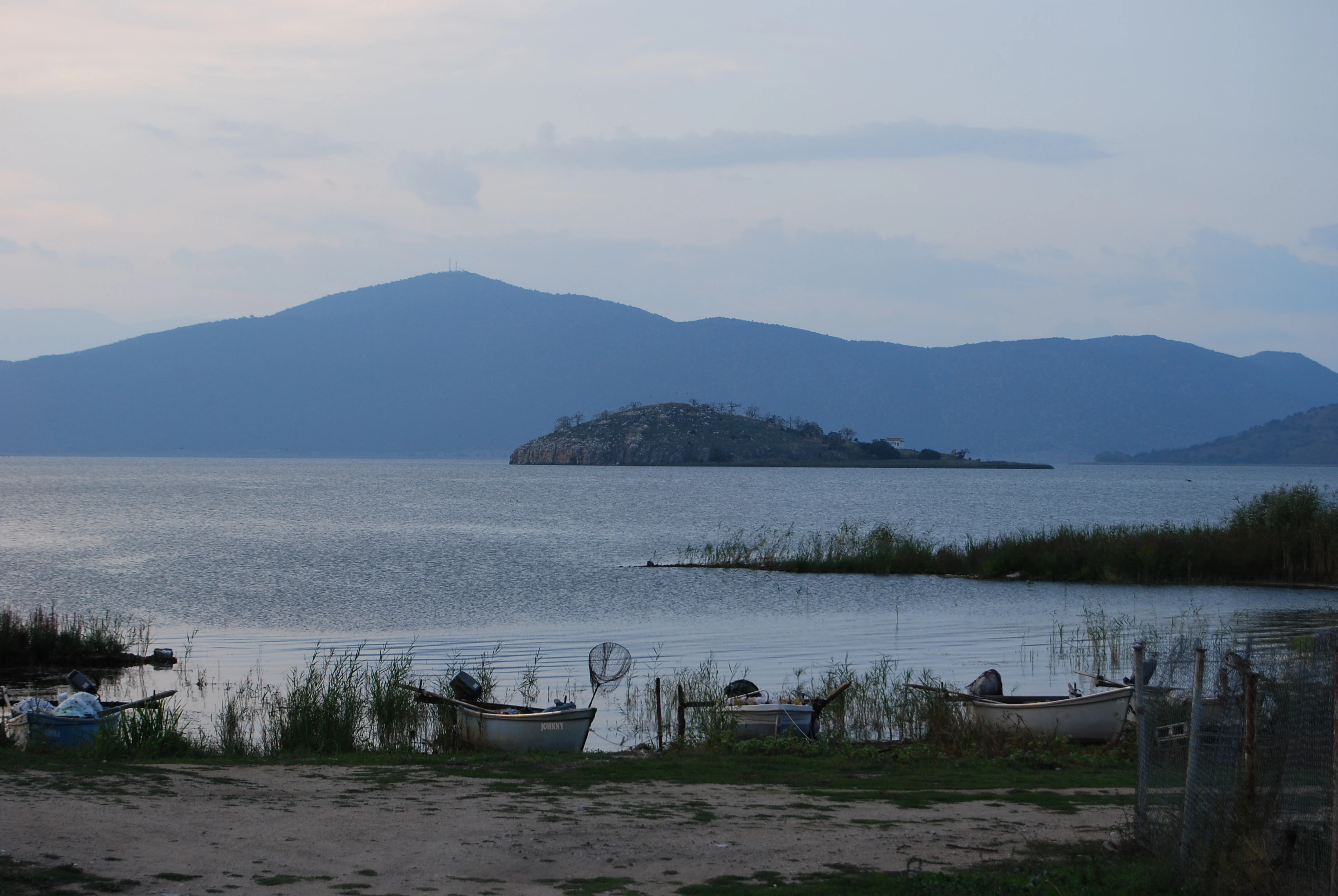
A calm lake landscape at dusk featuring Saint Achillios island in the middle distance, small fishing boats moored in the reeds in the foreground, and mountain silhouettes against a pale sky.
The island of Saint Achillios viewed from the shores of Lake Prespa.

Prespa National Park history and protected-area timeline

Prespa's protected-status history begins in 1974, when the area was first designated as Prespa National Forest, reflecting its early recognition for forest and watershed values. For several decades the area was managed primarily as a forest reserve, with the wetlands gaining international attention in parallel through bird-conservation initiatives.

A significant upgrade came in 2009, when the Greek state redesignated the area as Prespa National Park. This change broadened the management mandate from forest protection to a full ecosystem approach, formally incorporating the lakes, reed beds, agricultural buffer zones, and settlements into the protected-area framework.

The park's history is also shaped by the wider Prespa basin conservation movement. As concerns grew over water management, fish populations, and the survival of pelican colonies, the Greek park became one node in a regional effort that also includes protected areas on the North Macedonian and Albanian sides of the lakes.

Earlier, the area belonged to traditional rural communities such as Agios Germanos, whose long-standing relationship with the landscape, the lake, and the surrounding forests remains part of the park's cultural backdrop.

Prespa National Park landscape and geographic character

The landscape of Prespa National Park is defined by water and the hills that cradle it. Small Prespa Lake is the visual and ecological centerpiece, a shallow body of water fringed by extensive reed beds, muddy fringes, and floating vegetation mats. Beyond its immediate shore, the lake gives way to gently sloping terrain dotted with traditional villages and small cultivated plots.

Around the lake basin, forested uplands rise several hundred meters above the wetlands. These hills carry a patchwork of deciduous woodland, open meadows, and pasture, with views opening out across the lake surface toward the mountains of neighboring countries. The terrain is varied but never rugged, giving the park a softer, lake-dominated character compared with Greece's high-mountain parks.

Coastline in the conventional marine sense is absent, but the park has extensive lakeshore edge. The convoluted shoreline of Small Prespa Lake, with its reed-fringed bays and marshy inlets, is one of the most distinctive landscape features. Streams feeding the lake and seasonal floodwaters add a dynamic element to the topography, blurring the line between land and shallow water in many areas.

Prespa National Park ecosystems, habitats, and plant life

Ecologically, Prespa is anchored in its wetlands. The lake margins are dominated by extensive reedbeds, aquatic vegetation, and seasonally flooded meadows that provide breeding, feeding, and roosting habitat for waterbirds. These habitats are layered and highly productive, supporting complex food webs from invertebrates and amphibians through to large fish-eating birds.

Beyond the lakeshore, the park transitions into terrestrial ecosystems shaped by elevation and soil. Deciduous forests dominated by oak, hornbeam, and beech cover much of the upland. These woodlands grade into scrub and meadow on shallower soils, while steeper rocky areas host drier, more open plant communities. This altitudinal and moisture gradient is unusually compressed, producing an unusually high concentration of plant species.

The botanical richness of the park is one of its defining ecological features. Local flora has been documented at around 1,400 species, a striking figure that reflects the variety of microhabitats within a relatively compact area. Among these is Centaurea prespana, a plant endemic to the Prespa region, underscoring the basin's role as a center of localized botanical diversity.

Prespa National Park wildlife and species highlights

Prespa National Park's wildlife profile is dominated by birds, particularly waterbirds associated with its Ramsar-designated wetlands. Small Prespa Lake and the surrounding marshes host internationally important colonies of Dalmatian pelicans and great white pelicans, two of Europe's most range-restricted and conservation-sensitive waterbird species.

Beyond the pelicans, the lakes and reedbeds attract pygmy cormorants, great egrets, herons, and a rich guild of smaller wetland birds. The mix of open water, reedbed, and shoreline means the site supports both breeding and migratory species throughout much of the year, including seasonal influxes during spring and autumn passages.

Away from the water, the wooded hills host raptors such as the golden eagle, as well as a broader community of forest birds, small mammals, and reptiles typical of the broader Balkan forest-mosaic ecosystem. Although mammals are often less visible than birds, the park's mix of habitats provides refuge for typical species of southern Balkan woodland and scrubland environments.

Prespa National Park conservation status and protection priorities

Prespa National Park holds significant conservation weight at both national and international levels. The wetland complex around the lake basin is designated as a Ramsar site, recognizing its international importance for waterbirds and wetland ecological processes. This formal designation places the park among a select group of Greek wetlands with high-level conservation recognition.

The park also plays a transboundary role. The Prespa lakes are shared between three countries, and the survival of species such as the Dalmatian pelican depends on coordinated management across the basin. The Greek national park functions as one component of a larger conservation landscape that includes protected areas and initiatives in North Macedonia and Albania.

Conservation efforts in and around the park address water-level management, fish-stock dynamics, reedbed health, forest condition, and the delicate balance between traditional agriculture and ecological integrity. These pressures make the park an important long-term monitoring site for wetland biodiversity in southeastern Europe, and they elevate its status beyond that of a purely scenic reserve.

Prespa National Park cultural meaning and human context

The cultural backdrop of Prespa National Park is rooted in the traditional rural life of the Prespa basin. Small villages such as Agios Germanos, located near the lake, have shaped the surrounding landscape for centuries through small-scale agriculture, livestock grazing, and careful use of forest resources. A visitor center in Agios Germanos links modern park interpretation to this long-standing human presence.

Historically, the Prespa region carried cross-border cultural weight, tied to the Slavic and Greek communities that share the basin on different sides of the modern frontier. Stone-built villages, traditional agricultural patterns, and historic churches anchor the area's cultural geography, even as conservation interests now shape much of the land-use planning.

The park embodies a working balance between human communities and ecological protection. Many of the landscapes within the park boundaries are inhabited or actively managed, and the area's cultural dimension is an integral part of its identity rather than a backdrop.

Top sights and standout views in Prespa National Park

Prespa's signature highlight is the wetland bird spectacle of Small Prespa Lake, where breeding pelicans, pygmy cormorants, and a dense reedbed ecosystem create one of southeastern Europe's most important bird habitats.

Equally compelling is the park's botanical richness, with around 1,400 plant species documented in a compact area, including the endemic Centaurea prespana, giving Prespa an importance that extends well beyond its waterbird profile.

The park's transboundary character adds a further layer of significance, tying the Greek reserve to a broader Prespa basin conservation effort shared with neighboring countries.

Best time to visit Prespa National Park

The character of a visit to Prespa shifts meaningfully with the seasons. Spring and early summer are typically the richest period for birdwatching, when breeding colonies are active, water levels are favorable, and the surrounding meadows and forests are in full leaf. Migratory passage also adds diversity to bird lists during these months.

Autumn brings quieter conditions, attractive light over the lake, and the chance to observe migratory waterfowl as they pass through or settle on the wetlands. Winter can be cold, with frost and occasional snow at higher elevations, and reduced activity around the lakes, though the lake landscape itself remains visually distinct.

Summer offers long days and the most comfortable conditions for walking and exploring the villages and forest edges around the park, though bird activity around the colonies is generally lower than in spring.
Monthly climate preview

Long-term representative point measurements tracking temperature and precipitation patterns

Prespa National Park Climate Normals and Annual Weather by Month

Prespa National Park exhibits a measured annual rhythm ranging from freezing winter minimums to warm summer maximums alongside steady monthly precipitation records. Examining the complete twelve-month climatology profile reveals detailed long-term averages for temperature and rainfall across the protected terrain.
Annual mean10 °C
-1 °C22 °C
Jan-1°
Feb
Mar
Apr
May14°
Jun19°
Jul22°
Aug22°
Sep17°
Oct12°
Nov
Dec
Warmest month
August

22.3 °C

Coolest month
January

-0.9 °C

Wettest month
November

2.5 mm/day

Driest month
August

1.1 mm/day

Park location guide

Geography guide, regional context, and park location map for Prespa National Park

Prespa National Park park geography, regions, and map view in Greece

Understand where Prespa National Park sits in Greece through a broader geographic reading of the surrounding landscape, nearby location context, and its mapped position within the national park landscape.

How Prespa National Park fits into Greece

Greece, officially the Hellenic Republic, is a country in Southeast Europe occupying the southern Balkans. It borders Albania, North Macedonia, Bulgaria, and Turkey, with coastlines on the Aegean, Ionian, and Mediterranean seas. The country has over 10 million people and is renowned for its ancient Greek heritage, philosophy, democracy, and the Olympic Games.

Wider geography shaping Prespa National Park in Greece

Greece occupies the southern tip of the Balkan peninsula in Southeast Europe. It shares land borders with Albania to the northwest, North Macedonia and Bulgaria to the north, and Turkey to the east. The Aegean Sea lies to the east of the mainland, the Ionian Sea to the west, and the Sea of Crete and Mediterranean Sea to the south. The country spans thousands of islands across nine traditional geographic regions and has the longest coastline in the Mediterranean basin.

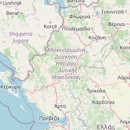
Map view of Prespa National Park

Use this park location map to pinpoint Prespa National Park in Greece, understand its exact geographic position, and read its mapped placement within the surrounding landscape more clearly.

Pigeon | © OpenStreetMap contributors

Location context for Prespa National Park

Western Macedonia
Recorded earthquake history

View the Historical Earthquake Catalogue for Prespa National Park

Explore a structured dataset of seismic events documented in the surrounding region of Prespa National Park. This catalogue provides a clear look at recorded activity using date, magnitude, and epicentre distance data, offering a transparent view of the historical record within the Western Macedonia landscape.

Prespa National Park Earthquake History

Catalogued events

517 events

Strongest magnitude

Magnitude 5.8

Most recent event

Sep 8, 2026

This history includes earthquakes recorded inside the park or within 50 km of its borders

Visualizing wetlands, lake ecosystems, and surrounding upland habitats

Prespa National Park Photos and Protected Landscape Scenery

Prespa National Park photos reveal the distinct protected area character of northern Greece through extensive wetland imagery and lake basin views. Visualizing shallow lake waters, reed beds, and forested upland terrain helps researchers understand the diverse habitats supporting rare regional bird populations.

A calm lake landscape at dusk featuring Saint Achillios island in the middle distance, small fishing boats moored in the reeds in the foreground, and mountain silhouettes against a pale sky.

A view of the stone bell tower and terracotta roofs of Agios Germanos village in the foreground; with the waters of Lake Prespa and snow-capped mountains in the background.

Park atlas

Compare regional geography, wetland habitats, and connected protected landscapes

Explore Other Parks Near Prespa National Park and Surrounding Protected Areas

Browse nearby national parks and protected areas to compare wetland ecosystems, forested uplands, and regional terrain across the surrounding landscape. Discovering related reserves provides broader context for regional conservation corridors and neighbouring natural habitats.
Watercolor painting of a river flowing through a valley with mountains and greenery
National parkKorçë County
Park boundaries overlap#1 closest

West

Prespa National Park: Protected Landscape and High-Altitude Lakes in Korçë County, Albania

Explore the geography and mapped boundaries of this vital national park.

Prespa National Park, located in Korçë County, Albania, is a protected area characterized by its significant high-altitude tectonic lakes, dramatic mountain landscapes, and vital wetland habitats. This entry provides a structured atlas-style overview of the park's geographic identity, its protected landscape features, and its ecological importance, serving as a key point of reference for understanding this unique Balkan region.

Area
276.131 km²
Established
1999
IUCN
II
Relief
Mountain
Watercolor painting of a landscape with green trees, rolling hills, and distant mountains under a light sky
National parkMunicipality of Bitola
5.2 km away#2 closest

Northeast

Pelister National Park: North Macedonia's Oldest National Park and Alpine Protected Landscape

Explore unique glacial features and endemic forests within Municipality of Bitola.

Pelister National Park, a pioneering protected area in North Macedonia, offers a rich tapestry of alpine geography and unique geological formations. This page provides detailed information on the park's landscape, including its dramatic mountain massif within Municipality of Bitola, the rare Macedonian pine forests, the striking 'stone rivers' formed by ancient glacial processes, and the serene Pelister Eyes glacial lakes. Discover the park's mapped boundaries and its significance as a conservation heritage site within the Balkan Peninsula.

Area
171.5 km²
Established
1948
IUCN
II
Visitors
30K annual
A soft watercolor painting of a lake landscape with rolling green hills, distant mountains, and gentle reflections in pale greens, pinks, and yellows.
Nature reserveNorth Macedonia
19 km away#3 closest

Northwest

Lake Ohrid Nature Reserve: Mapped Geographic Boundaries and Ancient Balkan Lake Ecosystems

A tectonic mountain lake system in North Macedonia

Lake Ohrid represents a monumental protected landscape within the mountainous southwestern Balkans. As one of the oldest and deepest lakes in Europe, it serves as a critical refuge for unique endemic species that exist in its clear, oligotrophic waters. This area showcases the complex interplay between tectonic geological history, high-mountain terrain, and the sustained conservation of a globally significant natural basin.

Area
358 km²
Relief
Mixed relief
Climate
Mediterranean
Access
Easy access
Protected landscapeKorçë County
About 22 km away#4 closest

Southwest

Fir of Drenovë-Sinicë Protected Landscape: Forest and Geological Map of Korçë County

Mapping Albania's protected Silver fir woodland ecosystems

Explore the structured geography of the Fir of Drenovë-Sinicë Protected Landscape, a diverse expanse in Korçë County defined by its ancient Silver fir stands and karst cave systems. This area showcases a varied landscape of rocky monoliths, mountain lakes, and tectonic valleys that serve as a vital ecological record for the southeastern Albanian mountains.

Area
10.3 km²
Established
1966
IUCN
V
Relief
Mountain
A soft watercolor painting of layered rolling hills and mountains fading into the distance with small clusters of stylized trees in the foreground.
Protected landscapeAlbania
About 40 km away#5 closest

West

Guri i Nikës-Lenie-Valamarë Protected Landscape: Albania Mountain and Forest Geography

A protected mosaic of Mediterranean woodlands and Pindus foothills

Spanning roughly 22 square kilometers near Pogradec, the Guri i Nikës-Lenie-Valamarë Protected Landscape protects a diverse array of forested slopes and freshwater habitats. This essential Balkan biological corridor provides a detailed look at the transition between dense woodland and scrub communities within the Pindus mountain system, highlighting its role as a key habitat for large carnivore populations.

Area
22 km²
Established
1996
IUCN
VI
Relief
Mountain
Watercolor illustration of mountains, a lake, and rolling hills with grassy vegetation.
National parkElbasan County
About 53 km away#6 closest

Northwest

Shebenik National Park: Mapped Protected Landscape and Glacial Terrain Atlas

Explore Elbasan County's significant mountain wilderness and protected natural features.

Shebenik National Park is a protected national park in Elbasan County, Albania, notable for its dramatic glacial terrain and extensive ancient forests. This park offers a deep dive into Albania's natural landscape, featuring 14 glacial lakes and serving as vital habitat. Its position within the Balkan Peninsula's geography makes it a key point of reference for understanding protected areas and mountain wilderness within a structured atlas.

Area
345.079 km²
Established
2008
IUCN
II
Relief
Mountain
Watercolor painting showing mountains, a river, and vegetation
National parkAlbania
59 km away#7 closest

West

Tomorr Mountain National Park: Sacred Peak & Karst Protected Landscape in Albania

Explore Albania's dramatic mountain geography and protected areas.

Tomorr Mountain National Park offers a unique exploration of southern Albania's dramatic limestone anticline. Dominated by the sacred Mount Tomorr and featuring the spectacular Osum Canyon, this national park provides insight into karst terrain, old-growth forests, and significant biodiversity. Discover its mapped boundaries and regional geographic context within the Pindus Mountains for structured atlas exploration.

Area
271.855 km²
Established
1956
IUCN
II
Relief
Mountain
Watercolor painting of a landscape with green fields, scattered trees, and rolling hills under a light sky
National parkGjirokastër County
About 68 km away#8 closest

Southwest

Fir of Hotovë-Dangëlli National Park: Ancient Forests & Mountain Wilderness Atlas

Explore a premier protected landscape in Gjirokastër County, Albania.

Fir of Hotovë-Dangëlli National Park stands as a monumental protected area, celebrated for its exceptional old-growth Hotova Fir forests, which are a rare Mediterranean plant relic. This national park in Gjirokastër County offers a detailed look at a vast mountainous terrain, featuring dramatic canyons like Lengarica Canyon, and serving as a critical habitat for diverse wildlife. MoriAtlas provides structured geographic context for this significant landscape, highlighting its mapped boundaries and role as a key component of regional protected area networks.

Area
360.038 km²
Established
2008
IUCN
II
Relief
Mountain

Common questions about visiting, size, designation, and location context for Prespa National Park

Prespa National Park FAQs for park facts, access, geography, and protected area context

Find quick answers about Prespa National Park, including protected-area facts, park geography, trail and visitor context, and how the park fits into its surrounding country and regional landscape.
MoriAtlas Explorer

Continue Your Protected Areas Search Across the Global Atlas

Deepen your exploration by continuing the structured search for national parks and protected areas worldwide. Utilize the comprehensive filtering capabilities to compare different conservation landscapes and refine your understanding of global park geography. Discover more about the distribution and characteristics of protected natural areas.

Global natural geography