Mori Atlas logo
Protected areaPuerto Arista

A vital sea turtle nesting sanctuary set where the Sierra Madre meets the Pacific Ocean

Puerto Arista Protected Area: Mapping the Pacific Coast and Coastal Geography of Chiapas

(Santuario Playas de Puerto Arista)

Puerto Arista represents a significant protected area along the northern coast of Chiapas, Mexico. This coastal landscape features broad volcanic sand beaches, extensive mangrove habitats, and critical nesting grounds for sea turtles. The region sits between the Gulf of Tehuantepec and the Sierra Madre de Chiapas, providing a distinct geographic intersection of marine and mountain ecosystems.

Pacific coastChiapasturtle sanctuarymangrovesfishing villagevolcanic sand beach

Puerto Arista

Protected area

Park overview

Structured park overview, official facts, and landscape profile for Puerto Arista

Puerto Arista park facts, protected area profile, and essential visitor context

Review the core facts for Puerto Arista, including designation, size, terrain, visitor scale, habitats, and operating context in one park-focused overview.

About Puerto Arista

Puerto Arista sits on the Pacific coast of Chiapas, framed by the Sierra Madre de Chiapas to the north and the open waters of the Gulf of Tehuantepec to the south. It lies within the municipality of Tonalá, in the Istmo-Costa region that forms part of the broader Isthmus of Tehuantepec, a transitional zone between central Mexico and Central America. The geography of the area is defined by a narrow coastal plain dotted with small ranches and fishing villages, where cattle pastures, mangrove estuaries, and long stretches of gray volcanic sand beach dominate the landscape.

The locality itself is laid out along a single main boulevard that runs parallel to the shore, lined with basic hotels, seafood restaurants, and small shops catering to visitors. At its center stands a nineteenth-century lighthouse, a reminder of Puerto Arista's earlier life as a shipping port. Climate in the area is warm and semi-humid, with most rain falling in summer and an average annual temperature of around 27°C. From the beach, the peaks of the Sierra Madre can be seen clearly, sometimes veiled by orographic cloud formations during the warmer months and by foehn-driven weather patterns in the cooler season.

The defining protected feature of Puerto Arista is the Santuario Playas de Puerto Arista, a sea turtle sanctuary created in 1986 and administered by Mexico's National Commission of Natural Protected Areas. The sanctuary protects a stretch of beach where olive ridley, leatherback, green, and hawksbill turtles come to nest, and is supported by an extensive mangrove system behind the shoreline. Puerto Arista is also nested within officially recognized marine and hydrological priority regions, underscoring its ecological value beyond sea turtles alone.

Today Puerto Arista functions as both a regional beach getaway and an active conservation site, with visitors able to take part in egg collection and hatchling releases. Despite its simplicity, the town remains the most visited coastal destination in Chiapas and one of the state's most recognizable tourist locations overall.

Quick facts and research context for Puerto Arista

Puerto Arista lies within the municipality of Tonalá in the Istmo-Costa region of Chiapas, roughly 195 kilometers from the state capital. The coast here is a narrow strip between the Sierra Madre de Chiapas and the Pacific Ocean, shaped by coastal plains, mangrove systems, and gray volcanic sand beaches extending for about thirty-two kilometers.

The Santuario Playas de Puerto Arista, covering roughly 212 hectares, was established by federal decree in 1986 and is part of broader marine and hydrological priority regions recognized by Mexico's biodiversity agency. The sanctuary sits on a property that also includes about 500 hectares of mangroves, making it one of the last remaining coastal marshland areas of its kind in the country.

Protection and recognition

Documented management scope and international recognition records

Puerto Arista Protection Status and Official Designation History

Puerto Arista maintains a documented mixed protection status established through historical designation records dating to 1986. Structured conservation data compiles official administrative frameworks and international recognition details for this protected area.

Protection details

Protection scope
Mixed
Designated year
1986
Transboundary protection
No
Park context

Deeper park guide and search-rich context for Puerto Arista

Puerto Arista history, landscape, wildlife, and travel context

Explore Puerto Arista through its history, landscape character, ecosystems, wildlife, conservation priorities, cultural context, and seasonal travel timing in a structured park guide built for atlas discovery and search intent.

Why Puerto Arista stands out

Puerto Arista is most recognized as Chiapas's principal beach destination and as the site of a long-running sea turtle protection program. The combination of a wide-open Pacific shoreline, the silhouette of the Sierra Madre de Chiapas rising inland, and a working turtle sanctuary draws both regional tourists and conservation-minded visitors. The town's identity is equally shaped by its fishing roots and its unusual history as a former nineteenth-century commercial port that transitioned, by circumstance rather than design, into a beach tourism economy during the twentieth century.
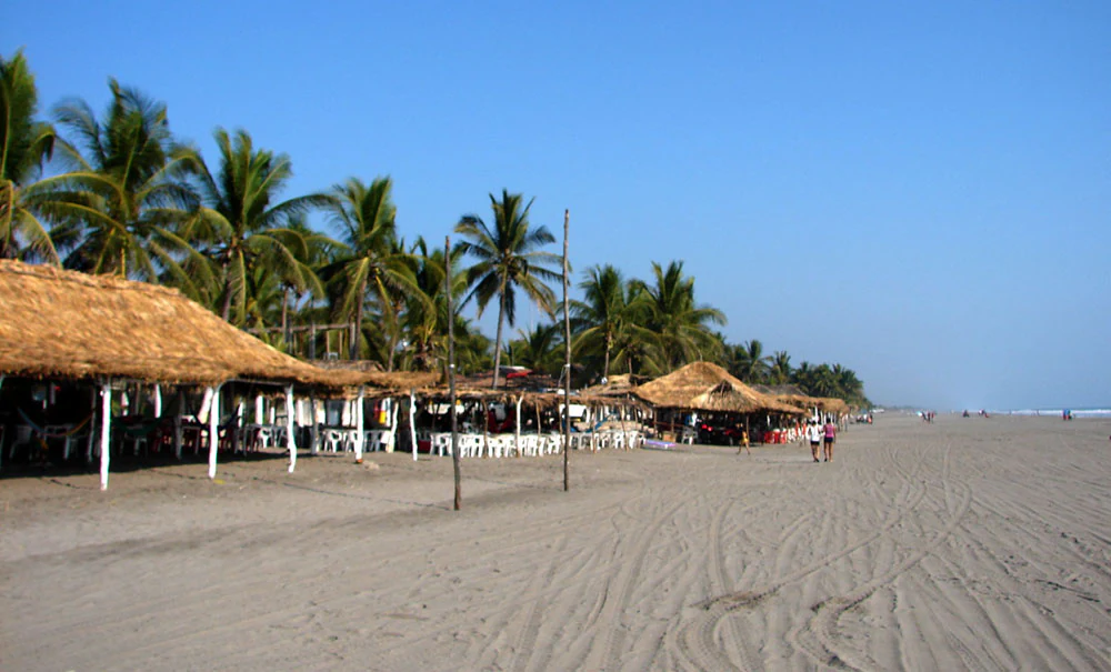
A wide beach with light sand and numerous thatched roof structures under palm trees, with the ocean visible in the distance under a clear blue sky.
Thatched roof palapas lining the sandy beach at Puerto Arista in Chiapas, Mexico.

Puerto Arista history and protected-area timeline

Puerto Arista was originally known as La Puerta and was first formally recorded in 1813, when the Cortes of Cádiz authorized it to trade with Guatemala and other ports of New Spain and Peru for a decade. In 1861, President Benito Juárez declared it a principal port for coastal navigation and foreign commerce, and during the latter half of the nineteenth century it became Chiapas's largest commercial plaza. Goods from as far away as Acapulco arrived here, and imports arrived from Germany, England, New York, San Francisco, Hamburg, Bordeaux, and Corinto, with cargo hauled overland at Panama before the canal opened.

By 1892 the governor of Chiapas, Emilio Rabasa, renamed the settlement in honor of former President Mariano Arista, and shortly afterward the federal government built a lighthouse to warn larger ships away from the unsafe waters. In 1890, the English company The Mexican Pacific Railroad Limited began constructing a railway line linking Puerto Arista to Tonalá, and in 1902 construction began on what would become the Panamerican Railway, connecting Puerto Arista to the inland network and eventually reaching the Guatemalan border.

The opening of the Panamerican Railway in 1908 drained Puerto Arista of its commercial shipping role, since goods now moved more efficiently by land. From that point the local economy pivoted, taking advantage of its coastal location and the productive fisheries of the surrounding municipality to develop into a tourism and fishing center. A road to Arriaga and Tonalá was completed in 1953, and in the decades that followed Puerto Arista consolidated its place as Chiapas's favorite beach.

Puerto Arista landscape and geographic character

The landscape of Puerto Arista is dominated by the contrast between sea and mountains. The settlement sits on a narrow coastal plain wedged between the Pacific Ocean and the Sierra Madre de Chiapas, whose peaks are clearly visible from the beach itself. The shoreline extends for about thirty-two kilometers of broad, open Pacific beach composed of fine gray volcanic sand. Inland from the beach lie cattle pastures and small ranching communities characteristic of the Istmo-Costa region, interspersed with estuarine and mangrove systems.

Climate and weather patterns reinforce the dramatic setting. During the warmer months, orographic cloud formations rise over the mountains, softening their outline; in the cooler months, foehn effects produce distinctive cloud patterns above the range. The tidal behavior of the coast also shapes daily life on the beach, with calmer, safer swimming conditions generally found at low tide, while stronger waves and rip currents can develop beyond the second line of wave breaks.

Puerto Arista ecosystems, habitats, and plant life

Ecologically, Puerto Arista sits within one of Mexico's formally recognized marine priority regions and within an important hydrological priority zone, the Soconusco region, which supports lentic and lotic water systems, coastal vegetation, migratory and aquatic birds, and freshwater fish and crustaceans. The area's mangrove estuaries, including systems associated with Laguna La Joya and the basins of the Zanatenco River, are among the last-remaining coastal marshland habitats of their type in the country.

The mangrove communities around the sanctuary include black mangrove, red mangrove, buttonwood, and white mangrove, forming dense belts of vegetation that shelter both terrestrial and aquatic wildlife. The protected area has also been identified for its high biological diversity, supporting a mix of resident, migratory, and at-risk species drawn to the combination of beach, mangrove, and freshwater resources.

Puerto Arista wildlife and species highlights

Sea turtles are the most prominent wildlife focus of Puerto Arista. Olive ridley, leatherback, green, and hawksbill turtles all nest on these beaches, making the sanctuary one of four state-run marine turtle protection sites in Chiapas. Beyond turtles, the protected area hosts crocodilian species including the spectacled caiman and the American crocodile, as well as mammals such as the ocelot, margay, raccoon, and tamandua anteater, and reptiles such as the black spiny-tailed iguana and the pond slider.

The birdlife is particularly notable. Resident and migratory species recorded at the site include the wood stork, reddish egret, great blue heron, bare-throated tiger heron, red-billed tropicbird, least storm petrel, agami heron, gray-headed kite, Harris's hawk, aplomado falcon, orange-fronted parakeet, common black hawk, northern shoveler, blue-winged teal, and northern pintail. The combination of mangrove, beach, and open ocean habitat creates conditions that support both long-distance migrants and species of conservation concern recognized under Mexico's NOM-059 list.

Puerto Arista conservation status and protection priorities

The Santuario Playas de Puerto Arista, established by federal decree in 1986, sits at the heart of the area's conservation significance. Administered by the National Commission of Natural Protected Areas, the sanctuary prioritizes the protection and recovery of sea turtle populations through beach patrols, relocation of freshly laid nests to protected corrals, and controlled release of hatchlings. Visitors are invited to participate in both egg collection and hatchling releases, making the site an important example of community-involved marine conservation in Mexico.

Beyond its role as a turtle sanctuary, Puerto Arista's protected status reflects broader regional ecological value. The site lies within CONABIO's Marine Priority Region No. 39 and Hydrological Priority Region No. 32, recognized for high biological diversity, presence of waterfowl and migratory birds, and its position as one of the country's last major coastal marshland zones. Despite these designations, the sanctuary has faced challenges over time, including periods of reduced staffing and infrastructure decline, and sea turtles remain under pressure from illegal fishing practices and nest poaching on the surrounding beaches.

Puerto Arista cultural meaning and human context

Puerto Arista's cultural identity is shaped by a layering of roles over more than two centuries. It began as a working commercial port tied to trade with Central America, the United States, and Europe, and later became a regional beach getaway once rail transport shifted goods away from the coast. The local population, known as portoaristenses, retains a fishing-and-tourism economy, with seafood palapa restaurants lining the boulevard and small-scale fishing continuing offshore.

The town also carries a quieter cultural layer tied to nineteenth-century Mexican history. Its renaming in 1892 honored former President Mariano Arista, and its nineteenth-century lighthouse, still standing at the center of town, anchors a sense of place that connects the present-day beach community to its earlier identity as a Pacific port.

Top sights and standout views in Puerto Arista

Chiapas's most-visited beach, set on the Pacific coast where the Sierra Madre de Chiapas meets the Gulf of Tehuantepec.

Home to the Santuario Playas de Puerto Arista, a 1986 federal sea turtle sanctuary that protects nesting beaches for olive ridley, leatherback, green, and hawksbill turtles.

Surrounded by one of the country's last major coastal mangrove systems, recognized under Mexico's national marine and hydrological priority region frameworks.

Long gray volcanic sand beaches offering open Pacific views, basic seaside hotels, and seafood palapa restaurants in a relaxed fishing-village setting.

Best time to visit Puerto Arista

Puerto Arista's warm, semi-humid climate makes it accessible year-round, but the experience shifts with the seasons. The summer months bring the majority of the region's rainfall and a softer mountain silhouette as orographic clouds gather over the Sierra Madre de Chiapas. During this same period, sea turtle nesting is most active, generally from July through November, making it the most meaningful window for visitors interested in the sanctuary's conservation work.

Holiday periods and major Mexican vacation weeks, particularly Holy Week and the Christmas season, are by far the busiest times, when the otherwise quiet town fills with regional visitors from Tuxtla Gutiérrez and beyond. Outside of these peaks and the summer rains, the beach tends to be calmer and the tide conditions more predictable, offering a quieter pace for those interested in the landscape and local fishing culture rather than the social scene.

Monthly climate preview

Long term temperature averages and precipitation rhythms across the coordinate point

Puerto Arista Climate Normals and Measured Monthly Weather Patterns

Representative baseline data reveals significant shifts in average monthly precipitation alongside steady annual thermal ranges across the coordinate point. Examining the complete twelve month profile provides deeper insight into measured meteorological variations over time.
Annual mean26 °C
24 °C28 °C
Jan24°
Feb25°
Mar26°
Apr28°
May28°
Jun26°
Jul26°
Aug26°
Sep26°
Oct25°
Nov24°
Dec24°
Warmest month
May

27.7 °C

Coolest month
December

23.8 °C

Wettest month
September

11.6 mm/day

Driest month
January

0.2 mm/day

Park location guide

Geography guide, regional context, and park location map for Puerto Arista

Puerto Arista park geography, regions, and map view in Mexico

Understand where Puerto Arista sits in Mexico through a broader geographic reading of the surrounding landscape, nearby location context, and its mapped position within the national park landscape.

How Puerto Arista fits into Mexico

Mexico, officially the United Mexican States, is a country in North America spanning the Sierra Madre mountain ranges, coastal plains, and tropical regions. It borders the United States to the north, Guatemala and Belize to the southeast, and has coastlines along the Pacific Ocean, Gulf of Mexico, and Caribbean Sea. With a population exceeding 130 million, Mexico is home to one of the world's most significant concentrations of Indigenous languages alongside Spanish.

Wider geography shaping Puerto Arista in Mexico

Mexico occupies a land area of 1,972,550 km2, making it the thirteenth-largest country in the world. The terrain is highly diverse, featuring the Sierra Madre Occidental and Sierra Madre Oriental mountain ranges, the Mexican Plateau, coastal lowlands along the Pacific and Gulf/Caribbean margins, and the Yucatan Peninsula. The country spans multiple climate zones from desert in the north to tropical rainforest in the south.

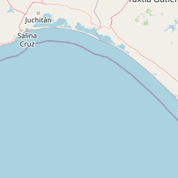
Map view of Puerto Arista

Use this park location map to pinpoint Puerto Arista in Mexico, understand its exact geographic position, and read its mapped placement within the surrounding landscape more clearly.

Pigeon | © OpenStreetMap contributors

Location context for Puerto Arista

Chiapas

Explore real imagery of volcanic sand beaches, mangrove ecosystems, and mountain backdrops

Puerto Arista Photos and Landscape Scenery: Visualizing Pacific Coast Protected Habitats

Visual records capture the distinctive topography where the Sierra Madre mountain range meets the open Pacific coastline. Photographic documentation reveals fragile sea turtle nesting habitats and coastal mangrove networks within the protected reserve.

A wide beach with light sand and numerous thatched roof structures under palm trees, with the ocean visible in the distance under a clear blue sky.

A person pushing a cart with a sign that says RICOS RASPADOS on a sandy beach, with the ocean and breaking waves in the background.

Park atlas

Compare coastal reserves and regional wildlife habitats across the surrounding landscape

Explore Protected Areas and Nearby Parks Around Puerto Arista

Browse protected areas and coastal habitats adjacent to Puerto Arista to compare regional park geography. Examining nearby reserves provides broader context on the conservation networks spanning the Pacific coast.
Natural monumentChiapas
About 203 km away#1 closest

Southeast

Volcán Tacaná Natural Monument: Stratovolcano Geography and Protected Landscape Context

A massive volcanic landmark spanning the Mexico and Guatemala frontier

Volcán Tacaná functions as an essential natural monument and active stratovolcano rising above the Chiapas region. Its geography includes dense cloud forests, high-altitude alpine zones, and geothermal activity, making it a pivotal feature of the Sierra Madre de Chiapas mountain range and a protected transboundary area.

Relief
Mountain
Climate
Tropical
Access
Moderate access
Scope
Terrestrial
National parkChiapas
About 227 km away#2 closest

East

Lagunas de Montebello National Park: Chiapas Protected Landscape Geography & Mapped Boundaries

Explore this national park's unique landscape context within Chiapas.

Lagunas de Montebello National Park offers a detailed view of protected landscape features and regional geographic context within Chiapas, Mexico. As a designated national park, its mapped boundaries are essential for understanding the distribution of protected areas and the natural terrain. This entity provides critical data for exploring the atlas of Mexican natural reserves and their specific environmental settings.

Area
64.11 km²
Established
1959
IUCN
II
Relief
Highland
A soft watercolor painting of a series of cascading waterfalls surrounded by light green foliage and rolling hills in the background.
Protected areaChiapas
About 232 km away#3 closest

Northeast

Cascadas de Agua Azul: A Geological and Hydrological Survey of the Chiapas Protected Area

Limestone canyons, rainforest biodiversity, and river hydrology

Cascadas de Agua Azul offers a unique perspective on the karst terrain of Chiapas, Mexico. The site features shallow canyons carved by the Otulún and Tulijá rivers, sustained by a humid microclimate that supports dense mountain rainforest. This protected area acts as a crucial link in the regional conservation network, safeguarding limestone-rich soil environments and diverse habitats for migratory and endemic bird species.

Relief
Upland
Climate
Tropical
Access
Moderate access
Scope
Terrestrial
National parkOaxaca
About 257 km away#4 closest

West

Huatulco National Park: Oaxaca's Key National Park Protected Landscape

Explore its mapped boundaries and regional geography.

Delve into the protected landscape identity of Huatulco National Park, situated within the rich geography of Oaxaca, Mexico. This detail page provides critical atlas-level information, focusing on the park's mapped boundaries and its contribution to the regional conservation landscape. Understand the foundational geographic context that defines this significant national park, essential for any exploration of Mexico's protected areas.

Area
118.9 km²
Established
1998
IUCN
II
Relief
Mixed relief
Protected areaChiapas
About 266 km away#5 closest

Northeast

Área de protección de flora y fauna Nahá-Metzabok: A Protected Landscape in Chiapas

Mapping tropical rainforests, karst hydrology, and cultural heritage

The Área de protección de flora y fauna Nahá-Metzabok serves as a vital corridor in the Lacandon Jungle, protecting humid rainforests and rare montane cloud forest habitats. Its rugged karst terrain is characterized by prehistoric rock-art caves and critical aquatic systems that sustain regional river basins, offering a layered study of ecological and cultural significance in southern Mexico.

Area
8,617.49 km²
Established
1998
A stylized vector illustration of tiered Mayan pyramid structures rising above a dense green jungle landscape under a soft pastel sky.
Biosphere reservePetén Department
About 291 km away#6 closest

Northeast

Maya Biosphere Reserve: Geographic Overview and Protected Landscapes in Petén

Tropical forest ecosystems and ancient archaeological mapping

Covering roughly one-fifth of Guatemala, the Maya Biosphere Reserve represents a pioneering model of zoned conservation. The landscape features a complex mosaic of lowland rainforests, savanna patches, and seasonal wetlands formed over a weathered limestone platform. This atlas summary examines the reserve's ecological boundaries, its vital role in protecting Mesoamerican biodiversity, and the concentration of pre-Columbian cities located across the Petén Department.

Area
21,602 km²
Established
1990
Relief
Mixed relief
Climate
Tropical
A soft, minimalist watercolor painting showing a winding river flowing through rolling green hills against a white background.
Wildlife reserveTabasco
About 297 km away#7 closest

Northeast

Cañón del Usumacinta Wildlife Reserve: Geography and Protected Area Mapping in Tabasco, Mexico

Tropical rainforest, karst cenotes, and riverine canyons

Cañón del Usumacinta represents an ecologically significant protected landscape in southeastern Mexico. This wildlife reserve features high evergreen rainforest, prominent river rapids, and karst geological features such as cenotes and caves. The reserve maintains critical biological continuity through its position in the Mesoamerican Biological Corridor, bridging remote riverine terrain with significant Maya archaeological sites.

Area
461.28 km²
Established
2005
Relief
Mixed relief
Climate
Tropical
Natural monumentOaxaca
About 304 km away#8 closest

West

Yagul Natural Monument: Geographic Profile and Protected Landscape Context in Oaxaca

Mapped terrain, cultural landscape, and Zapotec valley geography.

Yagul represents a critical intersection of archaeological heritage and semi-arid valley geography. By examining the site's artificial platforms, defensive hilltop positioning, and the surrounding network of rock shelters, one gains insight into the environmental factors that shaped this central hub of the Zapotec world. The protected area provides a defined boundary for investigating how ancient human activity successfully integrated with the complex, drought-prone terrain of the Oaxacan highlands.

Relief
Upland
Climate
Arid
Scope
Terrestrial
Water
Minor water

Common questions about visiting, size, designation, and location context for Puerto Arista

Puerto Arista FAQs for park facts, access, geography, and protected area context

Find quick answers about Puerto Arista, including protected-area facts, park geography, trail and visitor context, and how the park fits into its surrounding country and regional landscape.
MoriAtlas Explorer

Continue Your Protected Areas Search Across the Global Atlas

Deepen your exploration by continuing the structured search for national parks and protected areas worldwide. Utilize the comprehensive filtering capabilities to compare different conservation landscapes and refine your understanding of global park geography. Discover more about the distribution and characteristics of protected natural areas.

Global natural geography