Mori Atlas logo
Nature reserveReserva natural Barba Azul

Discover the complex ecological geography and protected boundaries of this critical macaw sanctuary.

Reserva natural Barba Azul: Mapping the Flooded Savannas and Gallery Forests of Beni, Bolivia

(Reserva Natural Barba Azul)

Reserva natural Barba Azul represents a vital protected landscape within the vast Llanos de Moxos of the Beni Department in northeastern Bolivia. This mosaic of seasonally flooded savanna, gallery forests, and motacú palm islands provides a crucial refuge for endangered species and migratory shorebirds. The reserve geography is defined by the shifting cycles of the Tiniji and Omi rivers, creating a dynamic terrain that sustains rare parrot habitats and diverse wetland ecosystems across its eleven thousand hectares.

blue-throated macawLlanos de Moxosflooded savannagallery forestmotacú palmprivate nature reserve

Reserva natural Barba Azul

Nature reserve

Park overview

Structured park overview, official facts, and landscape profile for Reserva Natural Barba Azul

Reserva Natural Barba Azul park facts, protected area profile, and essential visitor context

Review the core facts for Reserva Natural Barba Azul, including designation, size, terrain, visitor scale, habitats, and operating context in one park-focused overview.

About Reserva Natural Barba Azul

Reserva Natural Barba Azul is a private conservation area in the lowland savannas of northern Bolivia, situated about 75 kilometers west of the town of Santa Ana del Yacuma in the Beni department. It was established in 2008 by Asociación Civil Armonía, a Bolivian NGO recognized for macaw conservation, and grew out of long-running efforts to protect and recover the blue-throated macaw in its only remaining wild range.

The landscape is shaped by the extreme seasonality of the Llanos de Moxos. For roughly eight months of the year, from November through July, the terrain is largely under water. The remaining four months bring severe drought. The reserve therefore preserves a mosaic of flooded grasslands, gallery forests along the Tiniji and Omi rivers, and elevated forest islands dominated by the motacú palm (Attalea princeps), which together maintain the ecological structures the blue-throated macaw needs to nest and feed.

In recognition of its importance, the reserve was included in the Western Hemisphere Shorebird Reserve Network in 2015 as the first site in Bolivia, and in October 2020 the Plan de Ordenamiento Predial approved by Bolivia's forest authority formally declared the area a Reserva Privada de Patrimonio Natural. These layers of recognition transformed Barba Azul from a privately stewarded project into a legally anchored refuge for one of South America's most threatened parrots.

Quick facts and research context for Reserva Natural Barba Azul

Barba Azul is an 11,000-hectare private nature reserve in the Beni department of Bolivia, administered by the NGO Asociación Civil Armonía. It was created in 2008 and formally designated as a Reserva Privada de Patrimonio Natural in 2020.

The reserve falls within the Llanos de Moxos Ramsar site and the broader Llanos de Moxos ecoregion, a mosaic of seasonally flooded savanna, gallery forest, and palm-dominated forest islands. Its central conservation focus is the blue-throated macaw, a critically endangered parrot endemic to Bolivia, and the area also serves as a recognized regional site within the Western Hemisphere Shorebird Reserve Network.

Protection and recognition

Documented terrestrial protection scope and international recognition records

Reserva natural Barba Azul Protection Status and Designation History

Reserva natural Barba Azul maintains a documented terrestrial protection status established in the year 2020. Official records compile the designation history, management scope, and recognition data associated with this protected area.

Protection details

Protection scope
Terrestrial
Designated year
2020
Transboundary protection
No
Park context

Deeper park guide and search-rich context for Reserva Natural Barba Azul

Reserva Natural Barba Azul history, landscape, wildlife, and travel context

Explore Reserva Natural Barba Azul through its history, landscape character, ecosystems, wildlife, conservation priorities, cultural context, and seasonal travel timing in a structured park guide built for atlas discovery and search intent.

Why Reserva Natural Barba Azul stands out

The reserve is best known as the principal stronghold of the blue-throated macaw (Ara glaucogularis), a critically endangered parrot found only in a small portion of the Beni lowlands and long threatened by the illegal pet trade and habitat loss. Beyond the macaw, Barba Azul is valued for its intact mosaic of flooded savanna, gallery forest, and motacú palm islands, and for its importance as a stopover for migratory shorebirds moving between northern and southern hemispheres, including species such as the buff-breasted sandpiper and the American golden plover.
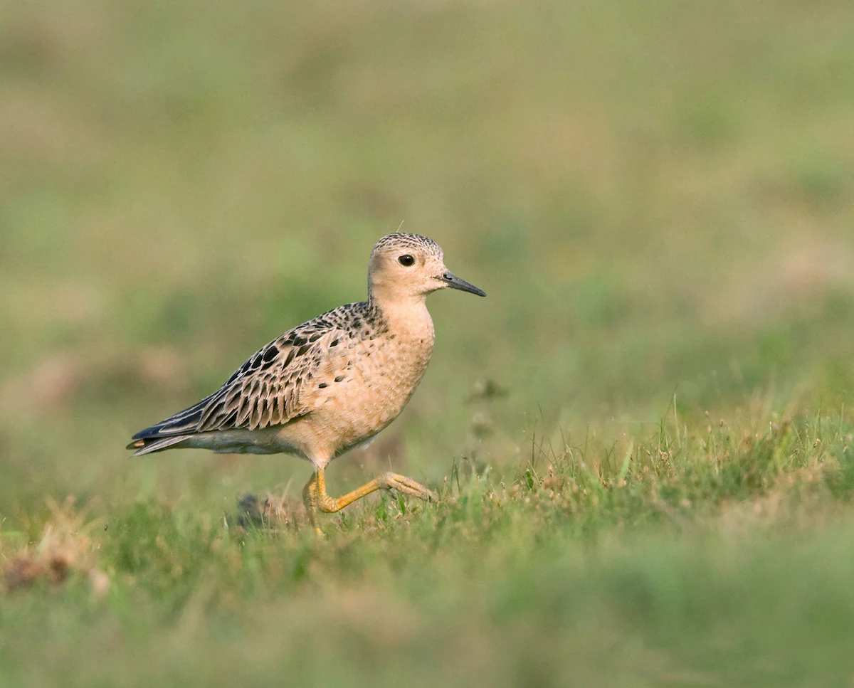
A buff-breasted sandpiper with light brown and speckled dark plumage walks across green grass.
A buff-breasted sandpiper walking through the grasslands of the Barba Azul Nature Reserve.

Reserva Natural Barba Azul history and protected-area timeline

The reserve was created in 2008 by Asociación Civil Armonía, motivated by the rapidly shrinking population of the blue-throated macaw, a species endemic to the Beni lowlands that had been heavily impacted by the illegal pet trade and the capture of live birds for collectors and zoos through the 1970s and 1980s.

In 2015 the site was accepted into the Western Hemisphere Shorebird Reserve Network as a site of regional importance, becoming the first Bolivian entry in the hemispheric shorebird reserve system. The Bolivian state declared the blue-throated macaw a Natural Patrimony of the Plurinational State of Bolivia in 2014, a step that strengthened the legal backdrop for the reserve's protection.

The next major milestone came in October 2020, when the Área de Patrimonio Natural approval process through the country's forest and land authority formally converted the property into a Reserva Privada de Patrimonio Natural. This designation locked in long-term private stewardship of the area and gave the NGO-backed reserve a formal institutional foundation within Bolivia's protected area framework.

Reserva Natural Barba Azul landscape and geographic character

The terrain of Reserva Natural Barba Azul is a textbook expression of the Llanos de Moxos landscape: an immense, gently undulating plain where savanna, palm forest, and river corridors alternate depending on elevation and water flow. The reserve sits on the Beni plain, where seasonal rainfall transforms much of the surrounding land into an inland sea for much of the year, then gives way to cracked dry ground during the dry months.

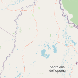
Two rivers define part of the reserve's geography. The Tiniji runs through the property and acts as a natural firebreak, separating vegetation types and limiting the spread of seasonal fires. The Omi, also within the reserve, supports islands of motacú-rich forest that rise slightly above the surrounding savanna and serve as important refuges for nesting macaws and other species when the lowlands flood. Around 75 kilometers east of the reserve lies the town of Santa Ana del Yacuma, the closest population center of any scale.

The result is a finely textured landscape that shifts character dramatically between the wet and dry seasons, from a near-aquatic mosaic of flooded grasslands and half-submerged trees during high water to a sunbaked savanna dotted with flowering palms and high-canopy forest patches during the dry season.

Reserva Natural Barba Azul ecosystems, habitats, and plant life

Ecologically, the reserve is part of the Llanos de Moxos, one of South America's most distinctive wetland-savanna systems and a Ramsar-recognized site for its biodiversity and hydrological importance. Within this broader mosaic, Barba Azul preserves a particularly valuable combination of seasonally flooded savanna, gallery forest along slow-moving rivers, and forest islands dominated by the motacú palm, a tree that defines much of the planting character of the Reserva Natural.

The motacú palm (Attalea princeps) is the single most ecologically significant species in the reserve. Its fruits feed the blue-throated macaw and many other birds and mammals, and the palm's flexible ecology, withstanding both flood and drought, allows it to persist in patches where other trees cannot. Local communities, including Tacana and Leco peoples, also rely on the palm for food, oil, fiber, and medicine, illustrating how the park's natural assets overlap with regional livelihoods.

The dramatic seasonal cycle is the other defining feature of the reserve's nature. Eight months of inundation create habitats for fish, amphibians, waterbirds, and aquatic invertebrates, while the four-month dry season concentrates wildlife around remaining water sources, riverine forests, and the shaded interior of the palm forest islands.

Reserva Natural Barba Azul wildlife and species highlights

The reserve's wildlife profile is dominated by birds, with roughly 320 species recorded and an unusually high concentration of parrots. About seventeen macaw and parakeet species share the landscape alongside the blue-throated macaw, taking advantage of the motacú palm forests and the mosaic of open and wooded habitats.

Migratory shorebirds are a major seasonal presence. The buff-breasted sandpiper, a near-threatened species, uses the reserve as an important stopover on its southbound journey, joined by pectoral sandpiper, Bartram's sandpiper, and American golden plover. On the northbound leg, the area is normally flooded, so these species continue onward to the llanos of Colombia and Venezuela. Among resident birds, the reserve holds vulnerable species such as the black-masked finch, the sharp-tailed tyrannulet, and the cock-tailed tyrant, alongside more familiar Neotropical species like the great kiskadee, the chimango caracara, the black vulture, and the southern screamer.

Mammals add another layer of conservation value. Pumas, jaguars in the broader Beni landscape, black howler monkeys, maned wolves, pampas cats, marsh deer, giant anteaters, lowland tapirs, and armadillos all inhabit or pass through the reserve's mosaic, while rheas roam the open plains. The combination of macaw, shorebird, and mammal diversity gives Barba Azul an unusually rich faunal character for an area of its size.

Reserva Natural Barba Azul conservation status and protection priorities

Reserva Natural Barba Azul is at its core a single-species sanctuary, built around the recovery of the blue-throated macaw, classified by the IUCN as critically endangered and listed in Appendix I of CITES. By protecting thousands of hectares of motacú-dominated habitat and enforcing patrols against poaching and illegal trade, the reserve safeguards the most important remaining wild population of this species.

The conservation approach extends well beyond the macaw itself. The reserve anchors a much larger network of values: it is part of the Llanos de Moxos Ramsar site, a recognized site in the Western Hemisphere Shorebird Reserve Network, and a formally registered Reserva Privada de Patrimonio Natural. This triple recognition, global wetland status, hemispheric shorebird status, and national private-reserve status, has turned Barba Azul into a model for how a small NGO can generate outsized conservation outcomes through targeted land protection.

The reserve also faces serious and ongoing threats. Habitat loss through logging, seasonal fires, overgrazing by cattle, and the steady advance of soybean and rice cultivation remain a concern across the Beni, while illegal bird trafficking still places pressure on wild parrots. In 2020 land invaders moved into part of the reserve, felling trees and introducing cattle, an incursion that Armonía reported to Bolivia's National Institute of Agrarian Reform. Cultural pressure exists as well: traditional dance regalia in the Beni has historically demanded large numbers of macaw tail feathers, although substitution with artificial feathers is gradually reducing this use.

Reserva Natural Barba Azul cultural meaning and human context

The reserve sits within the broader cultural geography of the Beni department, where indigenous and mestizo communities, including Tacana and Leco peoples, have long harvested the motacú palm for food, oil, fiber, and traditional medicine. These uses, from edible fruit to medicinal preparations, illustrate the deep regional relationship between local communities and the same palm landscapes that the reserve now protects.

The Beni is also the homeland of traditional dances whose cultural identity has been entangled with the region's parrots. The Danza de los Macheteros, a characteristic expression of the department, requires a headdress that historically included dozens of long tail feathers from Ara macaws. Declared intangible cultural patrimony of Bolivia in 2019, this dance illustrates how cultural practice, conservation, and macaw populations have intersected, sometimes problematically, in the same landscapes the reserve seeks to protect. Recent efforts to substitute artificial feathers for wild macaw plumes have begun to ease this pressure.

Top sights and standout views in Reserva Natural Barba Azul

Reserva Natural Barba Azul stands out for the convergence of three rare assets on a single site: a globally important stronghold for the blue-throated macaw, the only major private Ramsar-linked reserve of its kind in Bolivia, and a hemispherically recognized stopover for migratory shorebirds in the Llanos de Moxos.

Equally notable is the reserve's role as a working example of NGO-led conservation, where Asociación Civil Armonía combined long-term private land stewardship with formal Ramsar recognition, RHRAP listing, and a 2020 Reserva Privada de Patrimonio Natural designation to create one of the most carefully layered small-area conservation models in South America.

Best time to visit Reserva Natural Barba Azul

The reserve's character changes dramatically with the seasons, and the experience of a visit depends heavily on timing. The dry season, from roughly July through November, brings cooler temperatures, concentrated wildlife around remaining water and palm islands, and the best conditions for observing the blue-throated macaw, which is most active and visible when the landscape transitions from flood to drought.

The wet season, from about November into July, covers much of the reserve in shallow water and turns the savanna into a vast wetland mosaic. This is the period when shorebird viewing peaks for resident waterbirds and waterfowl, and when the motacú palms reach their fullest vegetation, though access becomes more constrained. Travelers sensitive to flooding conditions and heat should plan accordingly.
Monthly climate preview

Long-term monthly temperature and precipitation patterns recorded in Beni Department

Reserva natural Barba Azul Climate Normals and Annual Temperature Rhythm

Representative coordinate measurements reveal the sustained annual temperature and precipitation rhythm across Reserva natural Barba Azul from 1991 to 2020. Examining the complete monthly climate profile provides deeper context on long-term averages and seasonal variations.
Annual mean26 °C
24 °C29 °C
Jan26°
Feb26°
Mar26°
Apr26°
May25°
Jun24°
Jul25°
Aug27°
Sep29°
Oct29°
Nov27°
Dec27°
Warmest month
September

28.9 °C

Coolest month
June

24.3 °C

Wettest month
February

9.5 mm/day

Driest month
August

1.2 mm/day

Park location guide

Geography guide, regional context, and park location map for Reserva Natural Barba Azul

Reserva Natural Barba Azul park geography, regions, and map view in Bolivia

Understand where Reserva Natural Barba Azul sits in Bolivia through a broader geographic reading of the surrounding landscape, nearby location context, and its mapped position within the national park landscape.

How Reserva Natural Barba Azul fits into Bolivia

Bolivia, officially the Plurinational State of Bolivia, is a landlocked country in central South America. It features diverse geography including the Andean mountain range, Amazonian plains, Gran Chaco, and the Pantanal wetland. The country has a population of approximately 11.4 million and is administratively divided into nine departments, with La Paz as the seat of government and Sucre as the constitutional capital.

Wider geography shaping Reserva Natural Barba Azul in Bolivia

Bolivia is located in central South America, bordered by Brazil to the north and east, Paraguay to the southeast, Argentina to the south, Chile to the southwest, and Peru to the west. The country is divided between a western Andean region and tropical lowlands to the east and north. It includes the Amazonian plain, Gran Chaco, temperate valleys, the high-altitude Altiplano plateau, and part of the Pantanal wetland along its eastern border.

Map view of Reserva Natural Barba Azul

Use this park location map to pinpoint Reserva Natural Barba Azul in Bolivia, understand its exact geographic position, and read its mapped placement within the surrounding landscape more clearly.

Pigeon | © OpenStreetMap contributors

Location context for Reserva Natural Barba Azul

Beni Department

Visual exploration of seasonally flooded savanna, gallery forests, and critical wetland habitats in Bolivia

Reserva natural Barba Azul Photos and Protected Landscape Scenery

Photographic documentation reveals the distinct seasonal shifts of the Beni plain, capturing flooded grasslands during high water and sunbaked palm islands during dry months. Detailed imagery provides visual context for understanding the rare wetland habitats and conservation terrain that support endangered species.

A buff-breasted sandpiper with light brown and speckled dark plumage walks across green grass.

A mature Motacu palm tree with long, feathery fronds and a thick, textured trunk, standing in a garden with other trees in the background.

Park atlas

Compare surrounding wetland reserves and regional conservation landscapes

Explore Protected Areas and Parks Near Reserva natural Barba Azul in Beni

Browse neighboring protected areas and regional conservation zones sharing the flooded savanna terrain of the Beni plain. Expanding the search helps contextualize the specialized wetland habitats found around Reserva natural Barba Azul.
A horizontal watercolor painting of a river landscape with lush green vegetation in the foreground and soft, hazy hills in the background.
Protected areaBeni
About 68 km away#1 closest

West

Área protegida municipal Pampas del río Yacuma: Protected Area and Wetland Geography

A large-scale municipal sanctuary in the Bolivian Amazon

This significant protected area encompasses the expansive floodable savannas of the Llanos de Moxos. Its mosaic of forest islands and riverine wetlands provides a critical refuge for endemic species and iconic Amazonian wildlife. The geography is shaped by the Yacuma River, creating a seasonal environment that bridges indigenous heritage with modern conservation land management.

Area
6,164.53 km²
Established
2007
Visitors
16K annual
Relief
Lowland
A horizontal watercolor painting depicting a soft-focus landscape with green hills, a winding river, and reddish marshy foreground vegetation.
Biosphere reserveBolivia
About 69 km away#2 closest

South

Reserva de Biosfera Estación Biológica del Beni: Protected Landscape and Geographic Atlas

Examining the Amazonian lowland mosaic of northern Bolivia

The Reserva de Biosfera Estación Biológica del Beni sits within the wide alluvial plains of the Llanos de Moxos. This protected area features a unique, flat terrain where tropical forest fragments persist as islands amidst seasonally flooded palm savannas, cyperaceous marshes, and shallow lagoons, providing a critical study area for Amazonian biodiversity.

Area
1,350 km²
Established
1982
Relief
Lowland
Climate
Tropical
Regional parkBeni
About 110 km away#3 closest

South

Parque regional Yacuma: Geographic Overview and Protected Landscape Mapping

Riparian ecosystems and flooded savanna terrain in Beni, Bolivia

Explore the expansive floodplain mosaic of Parque regional Yacuma, where the Yacuma and Beni river systems create a vital refuge for lowland wildlife. The park offers an essential view into the seasonal transitions of northern Bolivia, bridging pre-Andean forests and inundated savanna plains that define this significant regional conservation corridor.

Area
1,200 km²
Established
1990
Water
Major water bodies
Protected areaBeni Department
About 141 km away#4 closest

West

Área Protegida Municipal Rhukanrhuka: Mapping Amazonian Biodiversity and Riverine Terrain

A transitional protected landscape in the Beni Department of Bolivia

Spanning a vast transition from Andean slopes to the Llanos de Moxos floodplain, Área Protegida Municipal Rhukanrhuka protects a dynamic mosaic of white-water rivers, gallery forests, and tectonic lakes. This significant municipal reserve serves as a refuge for threatened species and sustains indigenous Maropa communities within its borders, anchoring an essential conservation corridor in the northern Amazon.

Area
8,594.51 km²
Established
2019
Relief
Lowland
Climate
Tropical
A watercolor painting showing a soft, atmospheric landscape with a winding river, green banks, trees, and distant low hills against a white background.
Protected areaBeni Department
About 158 km away#5 closest

Southeast

Área Protegida Municipal Ibare-Mamoré: Geography and Protected Area Context

Riverine landscapes and wetlands in Bolivia's Beni Department

The Área Protegida Municipal Ibare-Mamoré encompasses a diverse range of ecosystems, from upland forests to open grasslands and shifting river channels. As a key conservation unit near the city of Trinidad, this area highlights the ecological importance of the Llanos de Moxos region through its interconnected aquatic and terrestrial habitats.

Area
256.08 km²
Established
2011
Relief
Lowland
Climate
Tropical
A pale, soft-toned watercolor illustration of a calm river landscape with rolling hills in the background and sparse trees along the banks.
Biosphere reserveBolivia
About 181 km away#6 closest

Southwest

Reserva de la Biosfera y Tierra Comunitaria de Origen Pilón Lajas Protected Landscape Atlas

Mapping the Andean Amazonian transition in northern Bolivia

Spanning from high mountain ridges to the river plains of the Beni, this protected area features a unique vertical gradient of ecosystems including cloud forests and terra firme. It represents a significant model for indigenous co governance and biodiversity protection within the broader Andean and Amazonian geographic context.

Area
4,000 km²
Established
1992
Relief
Mountain
Climate
Tropical
National parkLa Paz Department
About 211 km away#7 closest

West

Madidi National Park: National Park Protected Landscape and Geographic Atlas Entry

Explore mapped boundaries and regional context in La Paz Department.

Madidi National Park is a designated national park situated in Bolivia's La Paz Department. This detail entry offers a focused perspective on its protected landscape, its specific geographic setting, and its role within the larger atlas of natural areas. Understand the park's mapped boundaries and its contribution to the regional geography, providing a foundation for structured discovery of Bolivia's protected lands.

Area
18,957.5 km²
Established
1995
IUCN
II
Relief
Mixed relief
Protected landscapeBeni
About 214 km away#8 closest

Southeast

Parque Municipal y Área Natural de Manejo Integrado Gran Mojos: Regional Geography

Protected floodplain ecosystems in the Beni department of Bolivia.

Analyze the spatial distribution of this large protected area located in the Mamoré River basin. Learn about its dual-designation structure, bridging core municipal forests with integrated management zones that preserve vital lowland Amazonian habitats and endemic biodiversity within the Llanos de Moxos ecoregion.

Area
5,804.3 km²
Established
2017
Relief
Lowland
Scope
Terrestrial

Common questions about visiting, size, designation, and location context for Reserva Natural Barba Azul

Reserva Natural Barba Azul FAQs for park facts, access, geography, and protected area context

Find quick answers about Reserva Natural Barba Azul, including protected-area facts, park geography, trail and visitor context, and how the park fits into its surrounding country and regional landscape.
MoriAtlas Explorer

Continue Your Protected Areas Search Across the Global Atlas

Deepen your exploration by continuing the structured search for national parks and protected areas worldwide. Utilize the comprehensive filtering capabilities to compare different conservation landscapes and refine your understanding of global park geography. Discover more about the distribution and characteristics of protected natural areas.

Global natural geography