
Mori Atlas logo
Nature reserveRéserve naturelle nationale de la dune Marchand

A vital Flemish dune nature reserve in the Hauts-de-France region along the North Sea coastline.

Réserve naturelle nationale de la dune Marchand: Mapped Coastal Landscapes and Protected Geography

(Réserve naturelle nationale de la dune Marchand (RNN19))

The Réserve naturelle nationale de la dune Marchand encompasses a fragile and representative sequence of Flemish coastal dunes along the southern North Sea shore. This protected area in Hauts-de-France preserves a dynamic mosaic of mobile white dunes, stabilized grey dunes, and humid dune slacks shaped by constant maritime winds. The landscape serves as an essential ecological link for regional flora and fauna, including harbour seals, amphibians, and diverse specialist plants that thrive across this uniquely layered coastal terrain.

coastal dunesNorth SeaFlemish dunesdune slacksprotected nature reserveNatura 2000
A flat, vector-style illustration of a landscape with sand dunes, green grassy slopes, a winding blue stream, and a soft morning sky with clouds.

Réserve naturelle nationale de la dune Marchand

Nature reserve

Park overview

Structured park overview, official facts, and landscape profile for Réserve naturelle nationale de la dune Marchand

Réserve naturelle nationale de la dune Marchand park facts, protected area profile, and essential visitor context

Review the core facts for Réserve naturelle nationale de la dune Marchand, including designation, size, terrain, visitor scale, habitats, and operating context in one park-focused overview.

About Réserve naturelle nationale de la dune Marchand

The Réserve naturelle nationale de la dune Marchand is a French coastal nature reserve that protects a representative section of the Flemish coastal dunes on the North Sea shore of the Nord department. The reserve sits east of Dunkirk, on the territory of the communes of Bray-Dunes and Zuydcoote, in a stretch of coast very close to the Belgian frontier. The protected area has grown over time, from its original 83-hectare designation in 1974 to roughly 113 hectares following a 2024 extension decree, and forms a key node within the larger dune complex of the Hauts-de-France coast.

Physically, the reserve is shaped by the constant interaction of wind, sand, and salt spray. The dune ridge runs parallel to the shoreline and is scoured by strong coastal winds, which hollow out characteristic depressions. Within these sheltered slacks a different microclimate develops, supporting plant communities that cannot survive on the exposed dune faces. The varied topography has produced an unusually intricate mosaic of habitats on a relatively small surface, including pioneer beaches, mobile dunes, mature grey dunes with dense vegetation, and damp slacks where humidity-loving species thrive.

Ecologically, the site is significant for preserving almost the full natural dune vegetation sequence found in France. It supports hundreds of plant species, including several rare orchids and a small endemic, the Choin noirâtre. The combination of dry dunes, shrubby patches of sea buckthorn and grey poplar, and damper areas hollowed out by the wind creates conditions for a diverse fauna too: amphibians that use the wet slacks, bats that roost in remodelled wartime bunkers, and a notably rich bird community. Sections of the adjacent coast are also used as haul-outs and breeding sites for harbour seals.

As part of the Natura 2000 network and the wider dune landscape managed with the Conservatoire du littoral, the Dune Marchand plays an important role in the long-term conservation of the French North Sea coast, both as a refuge for native dune biodiversity and as a reference site for understanding how these dynamic landscapes can be protected in practice.

Quick facts and research context for Réserve naturelle nationale de la dune Marchand

Set along the North Sea coast in the Nord department, the Dune Marchand reserve protects a continuous strip of Flemish coastal dunes between Bray-Dunes and Zuydcoote, just east of Dunkirk. It is classified as a French Réserve naturelle nationale (national nature reserve) with the reference code RNN19, created in 1974 and significantly expanded by decree in 2024. Administratively it falls within the Hauts-de-France region and is managed by the Conseil départemental du Nord.

Ecologically the site is notable for hosting nearly the full natural dune vegetation sequence typical of the French coast and for combining dry dune habitats with dune slacks and small wetlands. It is part of a Natura 2000 Site of Community Importance designated in 2003 and links with the broader Grand site des Dunes de Flandre. The reserve is also embedded in a larger block of dune land acquired progressively by the Conservatoire du littoral between 1980 and 2004.

Protection and recognition

Documented terrestrial protection scope, designation year, and official database records

Réserve naturelle nationale de la dune Marchand Protection Status and Designation History

Terrestrial protection status records for Réserve naturelle nationale de la dune Marchand detail the official designation history established in 2024. Official database metrics trace the documented conservation framework and administrative parameters governing the protected area.

Protection details

Protection scope
Terrestrial
Designated year
2024
Transboundary protection
No
WDPA ID
4047
Park context

Deeper park guide and search-rich context for Réserve naturelle nationale de la dune Marchand

Réserve naturelle nationale de la dune Marchand history, landscape, wildlife, and travel context

Explore Réserve naturelle nationale de la dune Marchand through its history, landscape character, ecosystems, wildlife, conservation priorities, cultural context, and seasonal travel timing in a structured park guide built for atlas discovery and search intent.

Why Réserve naturelle nationale de la dune Marchand stands out

The Dune Marchand is best known for preserving one of the most complete and representative stretches of natural Flemish coastal dunes left in France, with the rare combination of mobile dunes, fixed dunes, dune slacks, and small pockets of wet woodland along a single short coastal strip. It is also recognised for harbour seal breeding activity along the adjacent shore, for a striking concentration of orchids and other dune-specialist plants, and for the presence of the Choin noirâtre, a regionally endemic plant linked to older dune grassland. These features together give the reserve an unusually rich ecological profile for such a compact coastal site.
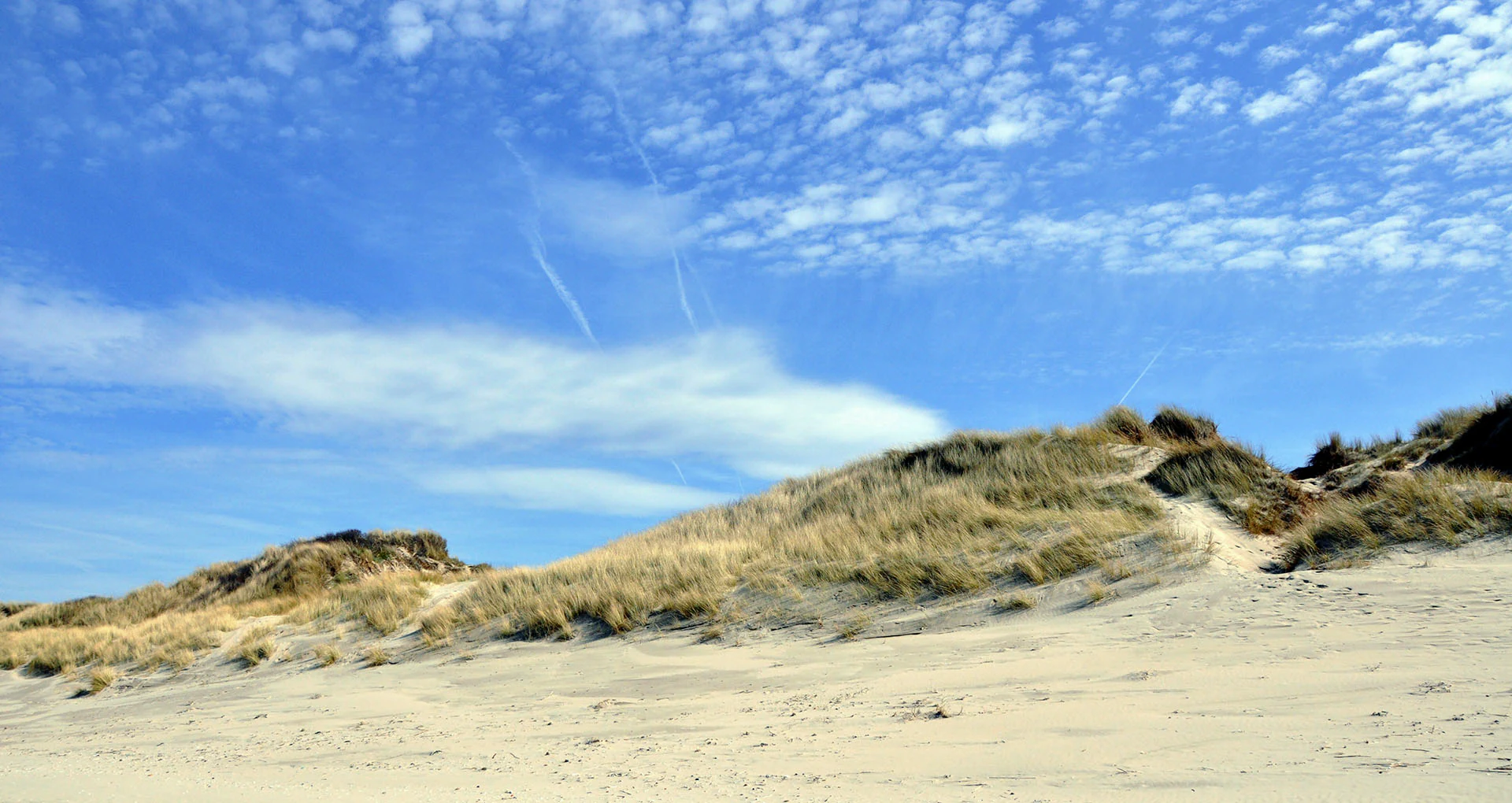
A wide view of coastal sand dunes covered in marram grass under a bright blue sky with scattered clouds.
Coastal dunes at the edge of the beach in Bray-Dunes.

Réserve naturelle nationale de la dune Marchand history and protected-area timeline

The Dune Marchand was formally established as a French Réserve naturelle nationale on 11 December 1974, through a ministerial order that recognised the scientific and ecological value of the Flemish dunes east of Dunkirk. The initial perimeter covered around 83 hectares of mobile and fixed dunes, dune slacks, and adjacent coastal vegetation.

In 1990 a new decree replaced the original order, reclassifying and reaffirming the reserve under the modernised French nature reserve framework. A more recent decree of 26 February 2024 extended the perimeter to approximately 113 hectares, broadening protection over additional dune habitat that had become ecologically significant since the original designation.

Alongside this statutory protection, the Conservatoire du littoral acquired more than 100 hectares of dune land in the area between 1980 and 2004, securing long-term conservation of a wider dune landscape around the reserve. In 2008, a volunteer work camp organised with the association CONCORDIA closed off several wartime bunkers within the dune to improve site safety and to convert them into refuges for bats and amphibians, an initiative coordinated with the Coordination mammologique du Nord. In 2003 the site was also integrated into the European Natura 2000 network as a Site of Community Importance.

Réserve naturelle nationale de la dune Marchand landscape and geographic character

The landscape of the Dune Marchand is shaped by the relentless action of wind and sea along the southern North Sea coast. The dune ridge runs parallel to the shoreline and rises in a long, narrow band flanked on one side by the beach and on the other by lower-lying reclaimed and semi-natural land. Because the coastal winds here are strong and relatively constant, the dunes are unusually dynamic, with active scouring that continually reshapes the surface.

Within the dune mass, characteristic hollows and depressions have been dug out by the wind. These slacks sit at a lower level than the surrounding sand and, in many cases, retain moisture close to the surface. The result is a striking alternation over short distances of dry, exposed crests and sheltered, sometimes damp basins. In winter and spring the slacks can hold temporary pools, while in summer they support distinct plant communities adapted to alternating wet and dry conditions.

Vegetation patterns follow this topography tightly. The most exposed faces are stabilised by marram grass and other pioneer plants, while the lee sides and older dunes carry denser cover of shrubs and small trees, including grey poplar, alder, ash, and flowering ash, interspersed with thickets of sea buckthorn. Where the dunes meet the backshore, the landscape transitions into wetter dune slack vegetation, reedbeds, and patches of marshy ground, giving the reserve a layered coastal scenery that is rare on this part of the French coast.

Réserve naturelle nationale de la dune Marchand ecosystems, habitats, and plant life

The ecological character of the Dune Marchand is defined by the coexistence of dry and wet dune habitats within a single protected perimeter. The mobile dunes and fixed grey dunes together preserve the classic sequence of natural dune vegetation that once dominated this stretch of coast, while the wind-scoured slacks introduce a contrasting humid microclimate that supports plants normally absent from open dune landscapes. Few French coastal sites combine these elements at such close range, which is why the reserve has long been treated as a reference site for Flemish dune ecology.

The vegetation includes the usual building blocks of a North Sea dune system: marram grass anchoring the seaward face, reed clumps in damper zones, and a wooded back-dune with grey poplar, alder, ash, flowering ash, and sea buckthorn thickets. Within the slacks and older fixed dunes, a notably diverse community of flowering plants persists, including multiple orchid species, marsh grass of Parnassus, helleborines, gentianellas, and small colonies of boreal relicts such as the Curtis's violet and pyrola.

A particular ecological signature of the site is the presence of the Choin noirâtre, a plant of conservation interest considered endemic to the regional dune context. The combination of 337 recorded plant species, of which two are protected at the national level, reflects how the topography of dune and slack creates many small, distinct microhabitats that together sustain a much richer flora than the reserve's modest size would suggest.

Réserve naturelle nationale de la dune Marchand wildlife and species highlights

Fauna at the Dune Marchand is diverse, partly because the dune's varied habitats offer very different living conditions within a small area. The reserve documents 162 vertebrate species, including six amphibians, a reptile, a range of mammals, and especially a rich bird community of roughly 140 species, of which about 35 are confirmed breeders.

Amphibians are a particular highlight. The wet dune slacks and damp depressions support natterjack toads and great crested newts, both species of conservation concern that depend on the open, sun-warmed pools that form after wind scouring. Mammals include bat species that have begun roosting in the wartime bunkers that were sealed off for their protection in 2008, alongside other small mammals typical of dune scrub and woodland edges.

The birdlife brings together residents and migrants. Breeding species include common nightingale, green woodpecker, willow warbler, common whitethroat, European stonechat, common linnet, thrushes, bramblings, and snow buntings in winter, while the wider dune landscape provides habitat for many passage migrants. Along the adjacent shoreline, harbour seals regularly use the area for reproduction, linking the reserve's dune ecosystem with the marine environment of the North Sea.

Réserve naturelle nationale de la dune Marchand conservation status and protection priorities

The Dune Marchand is significant for conservation because it safeguards one of the few remaining stretches of the French North Sea coast where the natural dune vegetation sequence is still essentially complete. This continuity is increasingly rare in northern France, where urbanisation, tourism infrastructure, and coastal defence works have fragmented many dune systems. By protecting mobile dunes, fixed dunes, dune slacks, and adjacent woodland patches under a single national designation, the reserve maintains the ecological processes that drive dune dynamics and allow specialised species to persist.

Its inclusion in the Natura 2000 network as a Site of Community Importance in 2003 reflects its European-level importance for dune habitats. The reserve also sits within a broader conservation landscape built up since 1980 by the Conservatoire du littoral, which gradually acquired surrounding dune land, and is part of the Grand site des Dunes de Flandre, an integrated management framework for the whole Flemish dune coast.

Specific management actions have targeted the most fragile features of the site. The 2008 conversion of wartime bunkers into shelters for bats and amphibians is a clear example of practical habitat creation inside the reserve. Maintaining public access on marked paths, while keeping sensitive slacks and breeding areas undisturbed, is central to balancing conservation with education and public engagement.

Top sights and standout views in Réserve naturelle nationale de la dune Marchand

The Dune Marchand stands out for bringing together four rare qualities on a small coastal footprint: a near-complete sequence of natural French dune vegetation; wind-scoured slacks that support both dry and damp specialist flora; a productive mix of breeding songbirds, amphibians, bats, and harbour seals; and an active network of national, departmental, and European conservation protections.

Its compact scale, combined with its proximity to Dunkirk and the Belgian border, makes it both an ecological refugium and a key node in the wider Flemish dune landscape managed with the Conservatoire du littoral and the Natura 2000 network.

Best time to visit Réserve naturelle nationale de la dune Marchand

The Dune Marchand can be experienced in different ways through the seasons, with the character of the dunes shifting noticeably between warmer and cooler months. In late spring and summer, the dune slacks fill with flowering plants and orchids, and amphibians are most active in the damp depressions, while the seaward dunes are at their busiest with breeding birds and insects.

In autumn and winter, the vegetation dies back and the bare sand and dune structures become more visible, offering a clearer sense of the underlying dune morphology shaped by wind. Winter is also a season when certain migrant birds, such as snow buntings and bramblings, are more likely to be encountered along the coast. Access throughout the year relies on staying on marked paths, so any visit is best planned around calm weather given the exposed coastal setting.
Monthly climate preview

Long-term temperature ranges and monthly precipitation patterns sampled at a representative coordinate

Réserve naturelle nationale de la dune Marchand Annual Climate Normals and Weather by Month

Recorded NASA POWER data spanning 1991 to 2020 outline monthly temperature ranges alongside daily precipitation averages across the protected landscape. Examining the full twelve-month profile reveals complete seasonal fluctuations in temperature and precipitation normals.
Annual mean11 °C
4 °C18 °C
Jan
Feb
Mar
Apr
May13°
Jun15°
Jul17°
Aug18°
Sep15°
Oct12°
Nov
Dec
Warmest month
August

17.7 °C

Coolest month
January

4.3 °C

Wettest month
November

2.7 mm/day

Driest month
April

1.4 mm/day

Park location guide

Geography guide, regional context, and park location map for Réserve naturelle nationale de la dune Marchand

Réserve naturelle nationale de la dune Marchand park geography, regions, and map view in France

Understand where Réserve naturelle nationale de la dune Marchand sits in France through a broader geographic reading of the surrounding landscape, nearby location context, and its mapped position within the national park landscape.

How Réserve naturelle nationale de la dune Marchand fits into France

France is a unitary semi-presidential republic and one of the world's largest economies. It borders Belgium, Luxembourg, Germany, Switzerland, Italy, Monaco, Andorra, and Spain, with a maritime border to the United Kingdom. The country is known for its cultural influence, art, cuisine, and political history spanning centuries.

Wider geography shaping Réserve naturelle nationale de la dune Marchand in France

France is located in Western Europe. Metropolitan France extends from the Rhine to the Atlantic Ocean and from the Mediterranean Sea to the English Channel and North Sea. The country borders Belgium, Luxembourg, Germany, Switzerland, Italy, Monaco, Andorra, Spain, and has a maritime border with the United Kingdom.

Map view of Réserve naturelle nationale de la dune Marchand

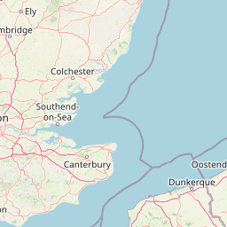
Use this park location map to pinpoint Réserve naturelle nationale de la dune Marchand in France, understand its exact geographic position, and read its mapped placement within the surrounding landscape more clearly.

Pigeon | © OpenStreetMap contributors

Location context for Réserve naturelle nationale de la dune Marchand

Hauts-de-France

Visual exploration of Flemish coastal dunes, mobile ridges, and humid slacks

Réserve naturelle nationale de la dune Marchand Photos and Coastal Scenery

Visual documentation captures the dynamic terrain of Réserve naturelle nationale de la dune Marchand across shifting white dunes and damp depressions. Detailed photography reveals fragile protected habitats, native vegetation, and coastal scenery along the North Sea littoral.

A wide view of coastal sand dunes covered in marram grass under a bright blue sky with scattered clouds.

Park atlas

Compare adjacent coastal landscapes and protected areas across the region

Exploring Parks Near Réserve naturelle nationale de la dune Marchand

Browsing other protected areas near Réserve naturelle nationale de la dune Marchand reveals continuous Flemish coastal dune habitats and shared North Sea ecosystems. Extending the geographic comparison highlights broader regional conservation networks and related coastal terrain.
Nature reserveHauts-de-France
About 16 km away#1 closest

West

Réserve naturelle régionale de Grande-Synthe: Protected Geography and Regional Mapping

Nature reserve landscapes in the Hauts-de-France coastal plain

Spanning 174 hectares on the edge of the Dunkirk urban zone, this protected area serves as a model for ecological restoration. Examine the patchwork of sandy grasslands, wetlands, and mature hedgerows that define the reserve, and see its position as a link in the regional green and blue ecological corridor of northern France.

Area
1.74 km²
Established
2015
Relief
Lowland
Climate
Temperate
A horizontal watercolor illustration depicting a soft, impressionistic landscape of wetland meadows, grassy patches, and distant trees in pastel shades of green, yellow, and soft purple.
Nature reserveHauts-de-France
About 20 km away#2 closest

South

Réserve naturelle régionale du vallon de la Petite Becque: Protected Area Map and Geography

Flemish Houtland wetland conservation and regional green infrastructure

This protected area in Hauts-de-France functions as a compact, high-value laboratory for habitat restoration within the modernized Flemish countryside. It provides essential sanctuary for relict marsh flora, orchid-rich meadows, and specialized invertebrate communities, effectively acting as an ecological island amidst a vast expanse of intensively cultivated arable farmland.

Area
0.009 km²
Established
2010
IUCN
IV
Relief
Lowland
A horizontal watercolor painting showing a soft coastal scene with rolling dunes, sparse grasses, and a calm shoreline under a light sky.
Nature reservePas-de-Calais
About 29 km away#3 closest

West

Réserve naturelle nationale du Platier d'Oye: Protected Coastal Landscape and Wetland Geography

Coastal dunes and migratory bird habitats in Pas-de-Calais

Located along the Opal Coast, the Réserve naturelle nationale du Platier d'Oye represents a complex mosaic of tidal flats, mobile sand dunes, and humid polder meadows. This protected area offers unique insight into the ecological intersection of maritime forces and terrestrial environments, functioning as a primary staging ground for diverse migratory species within the Hauts-de-France coastal region.

Area
3.91 km²
Established
1987
IUCN
IV
Relief
Lowland
A soft watercolor painting of a green meadow, featuring gentle hills in the distance, a small stream flowing through the center, and a few scattered trees, all set against a white background.
Nature reserveHauts-de-France
About 34 km away#4 closest

South

Réserve naturelle régionale des prairies du Schoubrouck: Geography and Protected Area Overview

Wet-meadow habitats and historic watergang networks in northern France.

Located in the Hauts-de-France region, Réserve naturelle régionale des prairies du Schoubrouck provides a focused look at the cultural and ecological heritage of Flemish lowland landscapes. This site preserves an essential mosaic of wet grasslands and traditional drainage systems, serving as a key example of habitat-specific conservation stewardship within the rural fabric of the Nord department.

Area
0.102 km²
Established
2012
IUCN
IV
Nature reserveHauts-de-France
About 42 km away#5 closest

Southwest

Réserve naturelle régionale de Pont d'Ardres: Mapped Wetland Geography and Protected Lands

A restored industrial landscape in the Hauts-de-France coastal hinterland.

Situated southeast of Calais, this reserve represents a rare success in ecological restoration. The former sugar factory basins now provide vital habitats for shorebirds and nesting species, maintaining an essential wetland presence in an otherwise cultivated landscape of northern France.

Area
0.663 km²
Established
2012
IUCN
IV
Relief
Lowland
Nature reserveHauts-de-France
About 43 km away#6 closest

South

Réserve naturelle régionale du plateau des landes: Regional Nature Reserve Landscape Profile

Protected heathland geography in the Pas-de-Calais corridor.

Understand the ecological structure of the Réserve naturelle régionale du plateau des landes. This protected area features a unique crescent shape and mosaic of heathland sectors spread across several communes, offering a focused study of low-elevation inland conservation management in the heart of northern France.

Area
1.811 km²
Established
2009
IUCN
IV
A soft watercolor painting showing a panoramic landscape with light green trees and low hills in the background, set against a pale, washed-out sky.
Nature reserveHauts-de-France
About 49 km away#7 closest

Southeast

Réserve naturelle régionale des prés du Moulin Madame: Regional Protected Meadow Map

Riverine floodplain landscapes in the Hauts-de-France region

The Réserve naturelle régionale des prés du Moulin Madame protects an 8.52 hectare corridor along the Lys river. This site highlights the preservation of traditional flood meadows that are increasingly rare in northern France. Users can examine the park boundaries, understand the flat lowland terrain, and trace the riverine geography that defines this unique protected cultural landscape.

Area
0.085 km²
Established
2015
IUCN
IV
A soft watercolor painting of a grassy landscape with exposed limestone rock faces and green vegetation.
Nature reserveHauts-de-France
About 53 km away#8 closest

Southwest

Réserve naturelle régionale des anciennes carrières de Cléty: Protected Geological Landscape

Regional nature reserve in the Hauts-de-France, France

A significant geological protected area in the Pas-de-Calais, this reserve features an exposed chalk quarry face that serves as a stratigraphic record for the Cretaceous period. The landscape hosts a rare intersection of geological heritage and diverse ecosystems, including orchids, butterflies, and bat colonies, within a compact footprint.

Area
0.02 km²
Established
2011
IUCN
IV

Common questions about visiting, size, designation, and location context for Réserve naturelle nationale de la dune Marchand

Réserve naturelle nationale de la dune Marchand FAQs for park facts, access, geography, and protected area context

Find quick answers about Réserve naturelle nationale de la dune Marchand, including protected-area facts, park geography, trail and visitor context, and how the park fits into its surrounding country and regional landscape.
MoriAtlas Explorer

Continue Your Protected Areas Search Across the Global Atlas

Deepen your exploration by continuing the structured search for national parks and protected areas worldwide. Utilize the comprehensive filtering capabilities to compare different conservation landscapes and refine your understanding of global park geography. Discover more about the distribution and characteristics of protected natural areas.

Global natural geography