
Mori Atlas logo
Nature reserveRéserve naturelle nationale de la falaise du Cap-Romain

Investigate the Bathonian marine cliff and Quaternary deposits of the Normandy coastline.

Réserve naturelle nationale de la falaise du Cap-Romain: Mapped Coastal and Geological Landmark

The Réserve naturelle nationale de la falaise du Cap-Romain protects a scientifically significant section of the Normandy coast near Saint-Aubin-sur-Mer. This maritime landscape preserves an exceptional record of Jurassic sponge reefs and Vistula glaciation erratic blocks. Examine the layered geological history and the distinct rocky tidal platform that defines this protected French nature reserve.

coastal reservegeological heritagefossil sitejurassic fossilsmarine fossilscliff
A flat-style digital illustration depicting a large, layered geological cliff with a waterfall cascading into a river winding through a valley.

Réserve naturelle nationale de la falaise du Cap-Romain

Nature reserve

Park overview

Structured park overview, official facts, and landscape profile for Réserve naturelle nationale de la falaise du Cap-Romain

Réserve naturelle nationale de la falaise du Cap-Romain park facts, protected area profile, and essential visitor context

Review the core facts for Réserve naturelle nationale de la falaise du Cap-Romain, including designation, size, terrain, visitor scale, habitats, and operating context in one park-focused overview.

About Réserve naturelle nationale de la falaise du Cap-Romain

The Réserve naturelle nationale de la falaise du Cap-Romain is one of the smaller and more specialized entries in France's network of national nature reserves. Located on the Côte de Nacre in Calvados, between Saint-Aubin-sur-Mer and Bernières-sur-Mer, it occupies a 24-hectare stretch of Normandy coastline where an 8-metre-high cliff meets a sandy beach and an eroded rocky platform. Although its footprint is modest, the density of geological and palaeontological features packed into it gives the site an importance well beyond its size.

The reserve exists primarily to protect a geological section of international interest. The cliff is cut into marl-limestone formations of Bathonian age, formed during the Middle Jurassic when this stretch of what is now Normandy lay beneath a shallow sea. Within these formations, erosion has exposed fossil sponge reefs of remarkable quality, with sponge bodies preserved in vertical, lobed, stacked, and contorted forms, alongside the shells, sea urchins, and microfossils of the surrounding marine community. The typifying species is Platychonia magna, and the fossil assemblage gives researchers an unusually complete picture of a Jurassic sponge colony and its ecological context.

The upper part of the cliff and its adjoining rocky shore add a second layer of geological interest from the Quaternary period. Coarse ferruginous gravels preserve cold-water mollusc shells from a former higher sea level during the Vistula glaciation, together with bones of woolly rhinoceros that lived alongside late mammoths. Above this lies wind-blown loess from the last glacial period, while large erratic blocks called "gas," transported by floating ice from the Cotentin coast, dot the rocky platform at low tide.

Culturally, the headland has been used continuously since the Mesolithic. Successive layers of occupation include a Gaulish temple, a Gallo-Roman villa, and a Merovingian necropolis. The celebrated Mother Goddess of Saint-Aubin-sur-Mer statue, found on the site in 1943 and now displayed at the Musée de Normandie in Caen, reflects this long human history. Today the reserve is managed by the Association Patrimoine Géologique de Normandie (APGN), which combines protection, scientific monitoring, and public education on a coastal site that links deep geological time with deep human time.

Quick facts and research context for Réserve naturelle nationale de la falaise du Cap-Romain

The Réserve naturelle nationale de la falaise du Cap-Romain is a French National Nature Reserve located on the Côte de Nacre in Normandy, in the Calvados department near Caen. Created by decree on 16 July 1984, it covers roughly 24 hectares, with most of its area belonging to the maritime public domain. The reserve is classified as IUCN Category III and focuses on the geological and palaeontological value of an 8-metre-high, 500-metre-long coastal cliff and its adjoining rocky platform.

Its principal interest lies in Jurassic-era fossil sponge reefs, especially those of Bathonian age, exposed by natural erosion in the marl-limestone formations. The cliff also preserves Quaternary deposits from the last glacial period, including erratics carried by ice rafts and beach gravels from the Vistula glaciation. The site is notable for combining geological heritage with a long history of human occupation reaching back to the Mesolithic.

Protection and recognition

Examine the official protection status, management framework, and recognized designation records.

Protection Status and International Recognition for Réserve naturelle nationale de la falaise du Cap-Romain

Explore the documented protection status and designated conservation framework assigned to Réserve naturelle nationale de la falaise du Cap-Romain within global protected area registries. Review verified administrative records and associated international recognition listings without speculative assumptions about environmental outcomes.

Protection details

WDPA ID
39789
Park context

Deeper park guide and search-rich context for Réserve naturelle nationale de la falaise du Cap-Romain

Réserve naturelle nationale de la falaise du Cap-Romain history, landscape, wildlife, and travel context

Explore Réserve naturelle nationale de la falaise du Cap-Romain through its history, landscape character, ecosystems, wildlife, conservation priorities, cultural context, and seasonal travel timing in a structured park guide built for atlas discovery and search intent.

Why Réserve naturelle nationale de la falaise du Cap-Romain stands out

The reserve is best known for its exceptionally preserved Jurassic sponge fossil reefs, exposed along an 8-metre-high coastal cliff on the Normandy coast. These Bathonian-age fossils, roughly 167 million years old, include distinctive clustered and lobed sponges such as Platychonia magna, set within a marl-limestone formation that also preserves associated shells, sea urchins, and tiny associated fauna. Equally distinctive is the Quaternary record layered above the Jurassic deposits. The cliff top and rocky shore carry coarse, ferruginous gravels dating to the Vistula glaciation, large erratic blocks known locally as "gas" deposited by ice rafts from the Cotentin coast, and wind-deposited loess from the last glacial period. Together, these features make Cap-Romain a compact but unusually rich geological archive bridging the Middle Jurassic and the Pleistocene.
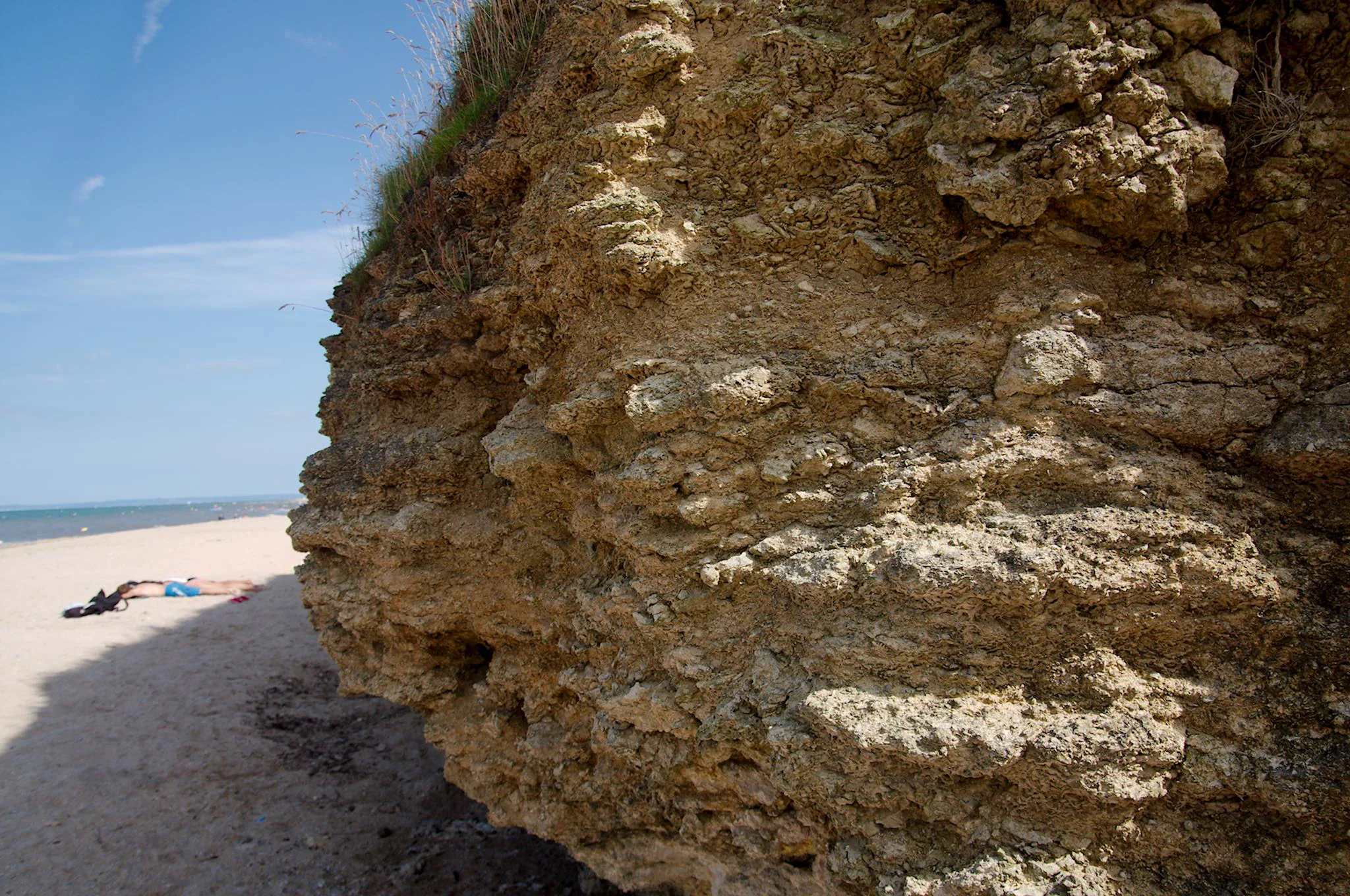
A close-up view of a rugged, textured Jurassic cliff face next to a sandy beach under a blue sky.
The fossiliferous Jurassic cliff face at Réserve naturelle nationale de la falaise du Cap-Romain, France.

Réserve naturelle nationale de la falaise du Cap-Romain history and protected-area timeline

The natural history recorded in the cliff of Cap-Romain reaches back around 165 to 167 million years to the Middle Jurassic, when the area was a sea floor inhabited by diverse sponge colonies that were buried and preserved in the marl-limestone sediments. Erosion over geological timescales has gradually exposed these fossils in the middle and upper parts of the cliff and along the rocky shore, creating the geological section that justifies the site's protection.

The human history of the headland is equally drawn out. The site has been occupied at least since the Mesolithic and remained in use through the early Middle Ages. Successive phases of occupation include a Gaulish temple, a Gallo-Roman villa, and a Merovingian necropolis. A notable artefact, the Mother Goddess of Saint-Aubin-sur-Mer, was discovered on the site in 1943 and is now conserved in the Musée de Normandie in Caen as evidence of these earlier communities.

In the modern era, recognition of the site's geological and palaeontological value led to its classification as a National Nature Reserve by decree on 16 July 1984, in the broader framework of France's national reserves system. Since then, the reserve has been managed by the Association Patrimoine Géologique de Normandie (APGN), which has overseen interventions such as planting sea buckthorn along the cliff-top path to slow accelerated erosion and the construction of groynes and rock armour to manage coastal retreat where small bays have begun to form.

Réserve naturelle nationale de la falaise du Cap-Romain landscape and geographic character

The landscape of Cap-Romain is a narrow but richly structured coastal scene typical of the Côte de Nacre. The reserve centres on an 8-metre-high maritime cliff that runs for about 500 metres along the Normandy coast, fronted by a sandy beach and a rocky tidal platform, or estran. Almost the entire reserve sits within the maritime public domain, reflecting how tightly the protected area is bound to the shore.

The cliff face itself is the dominant physical feature, cut into alternating marl and limestone of Bathonian age and visibly sculpted by wave action. At high tide, the sea reaches the foot of the cliff, and ongoing erosion is part of the site's character; small bays have begun to open in places where swirling currents bite into the rock. Groynes and rock armour have been installed along the most vulnerable points to slow this retreat, while sea buckthorn has been planted along the upper cliff path to reduce accelerated surface degradation.

Beyond the cliff itself, the beach and rocky platform form a second physical zone of interest. The estran carries scattered erratic blocks known locally as "gas"; these large sandstone and granite boulders, sometimes several cubic metres in volume, were carried northward by floating ice rafts during the last glaciation from the Cotentin coast. Today, fishermen use them as landmarks when navigating around the tidal platform, and they emerge clearly at low tide as one of the most distinctive physical elements of the reserve landscape.
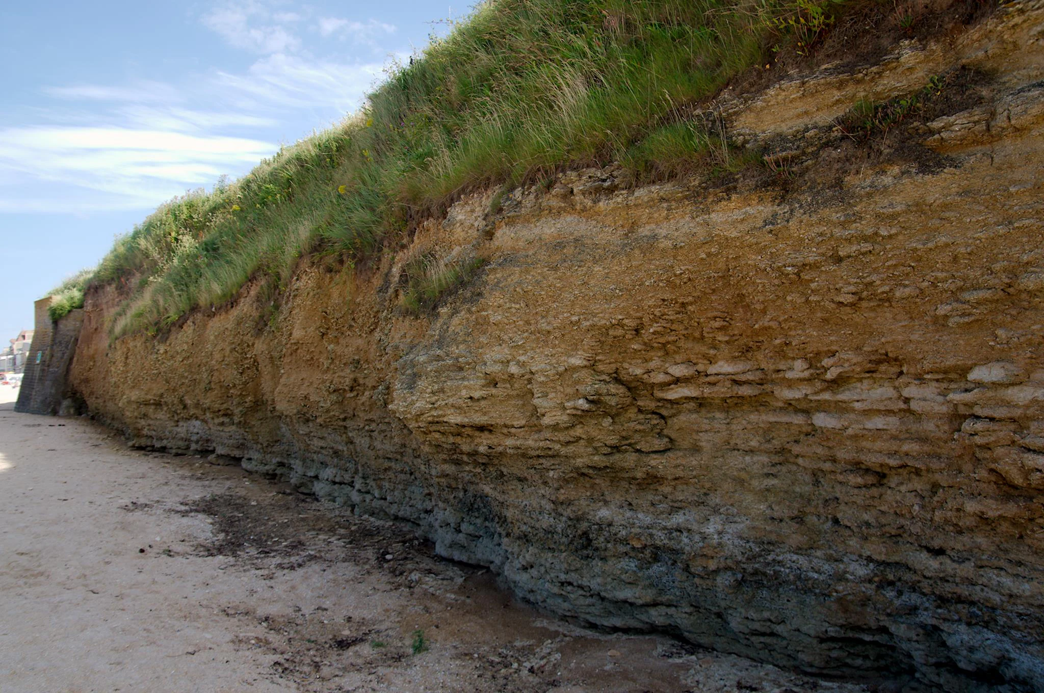
A low-angle view along the base of a coastal cliff showing distinct geological layers of yellow limestone and grey clay topped with green grass, with a sandy beach in the foreground.
The sedimentary rock formations of the Cap-Romain cliff, a site protected for its geological significance and Jurassic fossils.

Réserve naturelle nationale de la falaise du Cap-Romain ecosystems, habitats, and plant life

Ecologically, the Réserve naturelle nationale de la falaise du Cap-Romain is a coastal, marine-edge system shaped as much by geology as by biology. The combination of marl-limestone cliff, sandy beach, and rocky tidal platform creates a narrow but varied set of habitats within a very small footprint, supporting both intertidal communities and specialised cliff-top vegetation.

The cliff-top environment is stabilised in part by Elyme des sables, a nationally protected plant species in France that helps anchor the loose surface sediments. Along the upper cliff path, planted sea buckthorn shrubs further stabilise the ground and slow erosion that has been accelerating in recent decades. The beach and estran together host a modest but typical Normandy coastal flora, where the underlying geology and substrate type strongly influence what can grow.

Intertidally, the rocky platform supports communities of molluscs, arthropods, annelids, cnidarians, sponges, echinoderms, hemichordates, and fish. Though species diversity is higher toward the lower shore, total diversity remains relatively low, and densities of individual species are limited. The site is best understood ecologically not as a biodiversity hotspot in the conventional sense, but as a small but representative slice of Norman coastal habitat woven tightly into a much older geological framework.

Réserve naturelle nationale de la falaise du Cap-Romain wildlife and species highlights

The wildlife component of Cap-Romain is shaped by the reserve's small size and heavily marine-influenced setting. The most recent faunistic inventory, conducted in 2004, recorded 42 animal species commonly found along the Norman coast. Species diversity is highest on the lower shore, but overall diversity is modest and population densities of individual species are limited.

The most diverse groups are molluscs and arthropods, followed by annelids. Cnidarians, sponges, echinoderms, hemichordates, and fish are also present, though with lower diversity. Endogeous species have only been partially inventoried. On the rocky platform, common grazers such as patelles, littorines, gibbules, and chitons feed on encrusting and boring algae and unintentionally erode a thin film of limestone with each feeding pass; balanes contribute additional erosional activity, linking the smallest fauna to the larger geological structure of the cliff.

The reserve is also used by birds. Two notable species, the Tadorne de Belon and the Guillemot de Troïl, regularly frequent the site, reflecting its position along a coastal flyway and adding a seasonal wildlife presence to an environment otherwise dominated by geological and intertidal themes.

Réserve naturelle nationale de la falaise du Cap-Romain conservation status and protection priorities

The reserve's conservation value lies primarily in its geological and palaeontological significance rather than in a large-scale habitat-protection mandate. Within France's national nature reserves system, it serves as one of the small, highly specialised sites dedicated to preserving a key geological section, in this case a Jurassic sponge reef complex of international scientific interest. Its IUCN Category III designation reflects its management for a specific natural monument, the Bathonian-age cliff and its fossil assemblage.

Protection rests on the legal framework of the National Nature Reserves and on a set of practical management measures. Fossil collection is prohibited on the site, ensuring that the exposed Jurassic deposits and the overlying Quaternary layers remain available for study and public interpretation. Active interventions, including the construction of groynes and rock armour, and the planting of sea buckthorn along the upper cliff path, are used to slow both natural and accelerated erosion that might degrade the principal geological features.

Long-term management is provided by the Association Patrimoine Géologique de Normandie (APGN), which combines site protection with scientific monitoring and educational outreach. Through onsite signage and partnerships with research and heritage institutions, the reserve links conservation practice to public understanding of deep geological time, making it a useful reference point in discussions of how small reserves can carry disproportionately high scientific and educational value.

Réserve naturelle nationale de la falaise du Cap-Romain cultural meaning and human context

The headland at Cap-Romain carries a deep and unusually well-documented record of human occupation. The site has been in use at least since the Mesolithic, with continuous occupation through the early Middle Ages presided over by successive communities that left distinct cultural layers. A Gaulish temple, a Gallo-Roman villa, and a Merovingian necropolis have all been identified on or near the site, reflecting how the same coastal exposure that revealed its geology also exposed a stratified cultural landscape.

The most striking cultural artefact is the Mother Goddess of Saint-Aubin-sur-Mer, a statue discovered at the site in 1943 and now held by the Musée de Normandie in Caen. Its recovery brought broader public attention to the archaeological richness of the Cap-Romain headland and tied the reserve to the wider story of Gallo-Roman and post-Roman Normandy.

In the present day, cultural engagement with the site is more focused on interpretation than on active lived culture. The reserve's location along a coastal path used historically by French customs officers, the douaniers, and the integration of onsite explanatory panels reflect an effort to connect visitors with both the natural and human history of the headland, situating the reserve within the broader cultural identity of the Côte de Nacre.

Top sights and standout views in Réserve naturelle nationale de la falaise du Cap-Romain

Among the reserve's standout features, the Jurassic sponge fossil reefs of Bathonian age are the most distinctive, presenting one of the more complete records of Middle Jurassic marine sponge communities in northwestern Europe. The presence of identifiable species such as Platychonia magna, alongside preserved associated fauna, gives the cliff its scientific identity.

Equally striking is the layering of geological time within a single coastal section: Bathonian-age marine sediments at the base, Quaternary beach gravels and woolly rhinoceros bones from the Vistula glaciation in the middle, and wind-deposited loess from the last glacial cycle at the top. The erratic "gas" boulders scattered across the tidal platform add a physical, walkable dimension to this archive.

Finally, the reserve pairs this deep-time setting with a layered human story stretching from the Mesolithic to the early Middle Ages, anchored by the Mother Goddess of Saint-Aubin-sur-Mer and culminating in its 1984 designation as one of France's small but scientifically dense national nature reserves.

Best time to visit Réserve naturelle nationale de la falaise du Cap-Romain

The character of a visit to the Cap-Romain reserve varies considerably with the tides and seasons. Since the rocky platform and the base of the cliff are central to the site's geological interest, low tide is far more rewarding than high tide, when more of the estran, the fossil-bearing rock surfaces, and the famous "gas" erratic boulders are exposed. Visitors interested in seeing the cliff face and its fossil sponges up close will find the best conditions when the tide retreats fully.

Spring and summer typically offer the calmest weather, the longest daylight hours, and easier walking along the cliff-top path, which is also when coastal vegetation such as Elyme des sables is most visible. Autumn and winter bring stronger wave action, more visible erosion at the foot of the cliff, and a quieter atmosphere on the beach, but also the potential for rougher conditions and higher tides. For most visitors, a calm day around low tide in late spring or summer combines accessibility with the most complete view of the reserve's geological character.
Monthly climate preview

Long-term temperature ranges and monthly precipitation averages recorded at representative coordinates

Réserve naturelle nationale de la falaise du Cap-Romain Climate Normals and Annual Weather Patterns

Representative coordinates record sustained annual temperature shifts alongside measurable monthly precipitation variations across the protected area. Examining the complete twelve-month climatology profile reveals precise long-term averages for thermal progression and moisture distribution.
Annual mean12 °C
7 °C18 °C
Jan
Feb
Mar
Apr10°
May12°
Jun15°
Jul17°
Aug18°
Sep17°
Oct14°
Nov11°
Dec
Warmest month
August

18 °C

Coolest month
February

6.8 °C

Wettest month
December

3.4 mm/day

Driest month
June

1.6 mm/day

Park location guide

Geography guide, regional context, and park location map for Réserve naturelle nationale de la falaise du Cap-Romain

Réserve naturelle nationale de la falaise du Cap-Romain park geography, regions, and map view in France

Understand where Réserve naturelle nationale de la falaise du Cap-Romain sits in France through a broader geographic reading of the surrounding landscape, nearby location context, and its mapped position within the national park landscape.

How Réserve naturelle nationale de la falaise du Cap-Romain fits into France

France is a unitary semi-presidential republic and one of the world's largest economies. It borders Belgium, Luxembourg, Germany, Switzerland, Italy, Monaco, Andorra, and Spain, with a maritime border to the United Kingdom. The country is known for its cultural influence, art, cuisine, and political history spanning centuries.

Wider geography shaping Réserve naturelle nationale de la falaise du Cap-Romain in France

France is located in Western Europe. Metropolitan France extends from the Rhine to the Atlantic Ocean and from the Mediterranean Sea to the English Channel and North Sea. The country borders Belgium, Luxembourg, Germany, Switzerland, Italy, Monaco, Andorra, Spain, and has a maritime border with the United Kingdom.

Map view of Réserve naturelle nationale de la falaise du Cap-Romain

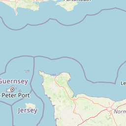
Use this park location map to pinpoint Réserve naturelle nationale de la falaise du Cap-Romain in France, understand its exact geographic position, and read its mapped placement within the surrounding landscape more clearly.

Pigeon | © OpenStreetMap contributors

Location context for Réserve naturelle nationale de la falaise du Cap-Romain

Normandie

Examine photographs of coastal cliffs, rocky shores, and marine fossil sites across the Normandy coast.

Visualizing Réserve naturelle nationale de la falaise du Cap-Romain: Coastal Scenery and Jurassic Fossil Cliffs

Visual documentation captures the coastal cliff morphology, rocky tidal platforms, and exposed Jurassic geological formations of Réserve naturelle nationale de la falaise du Cap-Romain. Photographic archives provide essential visual context for examining protected coastal landscapes and marine fossil archives.

A close-up view of a rugged, textured Jurassic cliff face next to a sandy beach under a blue sky.

A wide sandy beach meeting a grassy, sedimentary cliff face under a blue sky.

A low-angle view along the base of a coastal cliff showing distinct geological layers of yellow limestone and grey clay topped with green grass, with a sandy beach in the foreground.

Park atlas

Compare coastal nature reserves and regional protected landscapes across Normandy

Parks Near Réserve naturelle nationale de la falaise du Cap-Romain and Surrounding Protected Areas

Browsing other protected areas near Réserve naturelle nationale de la falaise du Cap-Romain provides wider geographic context for regional coastal terrain and geological reserves. Comparing adjacent conservation landscapes reveals how coastal cliffs and marine habitats connect across the broader northern French coastline.
A minimalist watercolor painting of soft green hills and light patches of color against a plain white background.
Nature reserveNormandie
About 40 km away#1 closest

Southwest

Réserve naturelle nationale de la forêt domaniale de Cerisy: A Normandy Protected Area

Ecological landscape and forest geography in France

Situated across the Calvados and Manche departments, this nature reserve protects a substantial beech-dominated state forest. The site provides a unique opportunity to study woodland ecosystems, endemic beetle conservation, and the transition between dense forest interiors and the surrounding Norman bocage landscape.

Area
21.24 km²
Established
1976
IUCN
IV
Relief
Upland
Watercolor painting of a river flowing through a valley with gentle green hills and trees on the banks.
Nature reserveCalvados
About 47 km away#2 closest

South

Rochers des Parcs Nature Reserve: A Detailed Atlas and Protected Landscape Overview

Geographic boundaries and cliff terrain in Calvados, Normandy.

The Rochers des Parcs nature reserve features dramatic Cambrian conglomerate cliffs rising above the Orne river in the Calvados department. This site is defined by its steep wooded slopes, rare plant species, and established network of hiking paths. It represents a vital area of conservation, protected for its geological interest and ecological value, providing a clear window into the rugged terrain of the Suisse normande landscape.

Area
0.36 km²
Established
1977
Relief
Upland
Scope
Terrestrial
A watercolor illustration showing a winding river flowing through a green marshland with soft tones and minimalist trees in the background.
Nature reserveManche
About 59 km away#3 closest

West

Réserve naturelle régionale des marais de la Taute: Mapped Landscape and Geography

Wetland geography and protected boundaries in Manche, France

Understand the physical characteristics of Réserve naturelle régionale des marais de la Taute, a mosaic of 147 hectares of protected wet meadows. This area serves as a significant site for marshland conservation, defined by its flat, low-lying river valley geography and fragmented parcel distribution across the Manche landscape.

Area
1.47 km²
Established
2011
Relief
Lowland
Climate
Temperate
A horizontal watercolor painting depicting a soft-toned landscape with a rocky scree slope in the foreground and rolling hills under a pastel sunset sky.
Nature reserveNormandie
About 87 km away#4 closest

South

Réserve naturelle régionale des pierriers de Normandie: Geographic Scree Slope Atlas

Examining rocky protected terrain in Normandy, France

The Réserve naturelle régionale des pierriers de Normandie protects one of the most distinctive natural scree slopes in northwestern Europe. This site preserves fragile rocky debris fields that support specialized vegetation and invertebrate communities. Our atlas data offers a close look at the boundaries and geological character of this significant protected landscape in the Orne department.

Area
0.009 km²
Established
2018
IUCN
IV
Scope
Terrestrial
Nature reserveFrance
About 89 km away#5 closest

South

Réserve naturelle régionale géologique de Normandie-Maine: Geological Nature Reserve

A protected Ordovician limestone site in the Armorican Massif

Located in northwestern France, this reserve focuses on the geological preservation of the Carrière des Vaux. It is an essential site for understanding Paleozoic biostratigraphy, featuring well-exposed limestone sequences and significant microfossil deposits that allow for precise dating of regional strata within the Normandie-Maine landscape.

Area
0.006 km²
Established
2009
Relief
Lowland
Climate
Temperate
A watercolor painting showing a soft, stylized landscape of a winding river surrounded by green hills, trees, and distant rolling hills on a white background.
Nature reserveNormandie
About 98 km away#6 closest

East

Réserve naturelle régionale de la côte de la Fontaine: Protected Landscapes of Normandie

Chalk coteau and calcareous grassland habitat atlas

Explore the geographic footprint of Réserve naturelle régionale de la côte de la Fontaine, a 12-hectare nature reserve in Normandie. This site features a rare chalk coteau habitat rising above the Seine River, creating a complex terrain of grasslands and wooded fringes that serve as a refuge for regional flora and fauna.

Area
0.12 km²
Established
1998
IUCN
IV
Relief
Upland
A pale watercolor landscape painting showing rolling green hills and distant mountain ridgelines against a white background.
Nature reservePays de la Loire
About 99 km away#7 closest

South

Réserve naturelle régionale Mont des Avaloirs: Protected Landscape and Geographic Overview

Upland heath and summit geography of the Armorican Massif

Investigate the unique physical geography of Réserve naturelle régionale Mont des Avaloirs. This area acts as a biodiversity stronghold in northwestern France, defined by a dramatic interplay of stony blockfields, sheltered valley brooks, and protected peatland basins that create atypical ecological conditions across the Mayenne countryside.

Area
3.211 km²
Established
2020
IUCN
IV
Relief
Mountain
A watercolor illustration of a soft, rolling landscape with green hills, a winding path or stream, and hints of pink flora in the foreground, set against a light background.
Nature reservePays de la Loire
About 105 km away#8 closest

South

Réserve naturelle régionale des landes et tourbière des Égoutelles Geographic Overview

Protected peat bog and wet heathland in Pays de la Loire

Located in Villepail, this nature reserve occupies a sheltered quarry depression in the Mayenne countryside. The site is a study in ecological resilience, featuring approximately one hundred plant species and a diverse fauna of dragonflies and amphibians that thrive in this compact, waterlogged habitat.

Area
0.013 km²
Established
2009
IUCN
IV
Relief
Lowland

Common questions about visiting, size, designation, and location context for Réserve naturelle nationale de la falaise du Cap-Romain

Réserve naturelle nationale de la falaise du Cap-Romain FAQs for park facts, access, geography, and protected area context

Find quick answers about Réserve naturelle nationale de la falaise du Cap-Romain, including protected-area facts, park geography, trail and visitor context, and how the park fits into its surrounding country and regional landscape.
MoriAtlas Explorer

Continue Your Protected Areas Search Across the Global Atlas

Deepen your exploration by continuing the structured search for national parks and protected areas worldwide. Utilize the comprehensive filtering capabilities to compare different conservation landscapes and refine your understanding of global park geography. Discover more about the distribution and characteristics of protected natural areas.

Global natural geography