Mori Atlas logo
Nature reserveRéserve naturelle régionale de la Poitevine-Regarde-Venir

Mapping the coussoul dry steppe and traditional hay meadow mosaic within the historic Crau plain

Réserve naturelle régionale de la Poitevine-Regarde-Venir: A Protected Steppe Landscape in Provence

(Réserve naturelle régionale de la Poitevine-Regarde-Venir (RNR6))

Located in the Bouches-du-Rhône department, the Réserve naturelle régionale de la Poitevine-Regarde-Venir preserves 221 hectares of the ancient Crau plain. This protected area showcases a rare ecological transition between dry, pebbly coussoul steppe and irrigated hay meadows. As a critical anchor for regional conservation, the site serves as vital habitat for steppe birds such as the little bustard and stone-curlew within the Mediterranean lowlands.

regional nature reserveCrau plaincoussouldry steppeMediterranean grasslandssteppe birds

Réserve naturelle régionale de la Poitevine-Regarde-Venir

Nature reserve

Park overview

Structured park overview, official facts, and landscape profile for Réserve naturelle régionale de la Poitevine-Regarde-Venir

Réserve naturelle régionale de la Poitevine-Regarde-Venir park facts, protected area profile, and essential visitor context

Review the core facts for Réserve naturelle régionale de la Poitevine-Regarde-Venir, including designation, size, terrain, visitor scale, habitats, and operating context in one park-focused overview.

About Réserve naturelle régionale de la Poitevine-Regarde-Venir

The Réserve naturelle régionale de la Poitevine-Regarde-Venir is a compact but ecologically distinctive protected area in the southern Crau, one of the most unusual natural regions in Provence. The Crau is a flat stony plain east of the Rhône delta, formed by ancient alluvial deposits from the Durance and shaped by centuries of pastoral use. Within this plain, the coussoul is the dry steppe grassland that grows on a coarse pebble layer and supports a remarkably specialised flora and fauna, found almost nowhere else in France.

The reserve brings together two neighbouring parcels, la Poitevine and Regarde-Venir, to form a continuous block of around 221 hectares. Roughly 140 hectares are occupied by coussoul, and the remaining area is made up of traditional hay meadows. This juxtaposition of dry steppe and mown grassland mirrors the broader ecological mosaic of the Crau and gives the reserve much of its conservation value.

As a regional nature reserve, the Poitevine-Regarde-Venir complements the larger national Réserve naturelle nationale des Coussouls de Crau, which lies only a few hundred metres away. Together, the two reserves form the backbone of habitat protection for the Crau's steppe communities and provide essential wintering and breeding habitat for birds that have declined sharply elsewhere in western Europe.

Quick facts and research context for Réserve naturelle régionale de la Poitevine-Regarde-Venir

The Réserve naturelle régionale de la Poitevine-Regarde-Venir is classified as a regional nature reserve under the French UICN category IV (habitat and species management). It was created on 10 July 2009 by a regional council deliberation, initially for a renewable 12-year term, and is managed by the Conservatoire d'espaces naturels de Provence-Alpes-Côte d'Azur.

The site sits on the commune of Grans in the Bouches-du-Rhône, between Arles and Salon-de-Provence, and combines two contiguous estates: the meadows and coussoul of la Poitevine, already designated as a voluntary nature reserve in 1988, and the coussoul of Regarde-Venir, added later to extend the protected area. The Crau plain itself is also covered by complementary designations such as Special Conservation Zones and ZNIEFF inventories.

Protection and recognition

Examine documented protection status and official database records for this regional reserve.

Protection Status and International Recognition for Réserve naturelle régionale de la Poitevine-Regarde-Venir

Examine documented protection status and baseline database records for Réserve naturelle régionale de la Poitevine-Regarde-Venir. Structured geographic facts bring together official conservation entries and administrative data for detailed atlas analysis.

Protection details

WDPA ID
555514400
Park context

Deeper park guide and search-rich context for Réserve naturelle régionale de la Poitevine-Regarde-Venir

Réserve naturelle régionale de la Poitevine-Regarde-Venir history, landscape, wildlife, and travel context

Explore Réserve naturelle régionale de la Poitevine-Regarde-Venir through its history, landscape character, ecosystems, wildlife, conservation priorities, cultural context, and seasonal travel timing in a structured park guide built for atlas discovery and search intent.

Why Réserve naturelle régionale de la Poitevine-Regarde-Venir stands out

The reserve is best known for protecting a fragment of the famous Crau coussoul, the ancient dry steppe that lies at the heart of Provence's natural heritage. Its coussoul habitat hosts wintering little bustards and stone-curlews, two of the most characteristic steppe birds of the Mediterranean lowlands. The site is also appreciated for the unusually intact combination of dry Crau and wet Crau found in such a small surface area, giving it a strong representative value within the broader Crau conservation network.

Réserve naturelle régionale de la Poitevine-Regarde-Venir history and protected-area timeline

The Poitevine-Regarde-Venir reserve has its origins in two separate landholdings and a longer local initiative. The meadows and coussoul of la Poitevine were first recognised in 1988 when 149 hectares were classed as a voluntary nature reserve, an earlier French mechanism that allowed private landowners to commit to protecting their land.

The coussoul of Regarde-Venir, a contiguous parcel of about 72 hectares, was later brought into the same conservation framework. The combined area was eventually elevated to regional nature reserve status by a délibération of the Provence-Alpes-Côte d'Azur regional council on 10 July 2009, granting the site formal protection for an initial renewable term of 12 years and placing its management under the Conservatoire d'espaces naturels de Provence-Alpes-Côte d'Azur.

Réserve naturelle régionale de la Poitevine-Regarde-Venir landscape and geographic character

The reserve sits in the flat, dry expanse of the Crau, a stony plain that lies west of the étang de Berre and east of the Camargue. At ground level, the defining feature is the coussoul, an open steppe of low grasses and herbs growing over a thick layer of rounded pebbles left behind by ancient Durance river deposits. This unusual substrate gives the Crau its characteristic arid appearance and a steppe-like character typical of much drier climates.

Around the coussoul, the landscape shifts to hay meadows of the wet Crau, where deeper soils allow denser grass growth and traditional mowing. The reserve also contains a small planted parcel with almond and olive trees, a reminder of the agricultural heritage of the plain, while the RN 569 road crosses the area but is excluded from the protected perimeter. Together, these elements create a mosaic of open steppe and cultivated meadow that reflects the long interaction between natural processes and human pastoral use in the Crau.

Réserve naturelle régionale de la Poitevine-Regarde-Venir ecosystems, habitats, and plant life

Ecologically, the reserve's principal interest is its near-complete representation of Crau habitats in a compact footprint. The coussoul is the defining ecosystem of the site and supports a specialised flora adapted to the dry, pebbly substrate, while the surrounding hay meadows reflect the wet Crau, where traditional mowing maintains a very different plant community.

The interplay between these two environments, in such close proximity, gives the Poitevine-Regarde-Venir strong value for understanding and conserving the wider Crau's ecological character. The Crau plain as a whole is also recognised through overlapping European and French designations, including Special Conservation Zones and ZNIEFF inventories, which reinforce the importance of habitats found within the reserve.

Réserve naturelle régionale de la Poitevine-Regarde-Venir wildlife and species highlights

The reserve is particularly significant for birds of the Crau steppe. Its coussoul habitat is an important wintering area for the little bustard, a steppe species that has undergone major declines in western Europe and remains one of the most threatened birds of the Mediterranean lowlands. The open, dry grasslands offer the kind of undisturbed conditions the species relies on during the winter months.

The stone-curlew is also present on the site, sharing the open steppe habitat and contributing to the reserve's role as a refuge for ground-nesting birds. Beyond these two flagship species, the reserve supports the broader bird and insect communities typical of the Crau coussoul and hay meadows, although detailed inventories are not featured in the main source material.

Réserve naturelle régionale de la Poitevine-Regarde-Venir conservation status and protection priorities

From a conservation standpoint, the Poitevine-Regarde-Venir is the regional counterpart to the nearby national nature reserve of the Coussouls de Crau, and the two sites together carry much of the responsibility for protecting Crau steppe habitats in the long term. Classed under UICN category IV, the reserve is explicitly aimed at managing and maintaining a particular habitat and its associated species.

The reserve's value lies in protecting roughly 140 hectares of coussoul, a habitat that is both rare in France and heavily shaped by historical pastoral use, along with adjacent hay meadows. Its designation in 2009 strengthened an existing layer of protection, since the area was already part of broader European and French inventories such as Special Conservation Zones and ZNIEFF. Public access is restricted, with both circulation and parking prohibited on the site, helping to limit disturbance to wintering birds and to maintain the integrity of the steppe habitat.

Réserve naturelle régionale de la Poitevine-Regarde-Venir cultural meaning and human context

The Crau plain has been shaped by human activity for centuries, and the Poitevine-Regarde-Venir reflects this long history. The coussoul itself is a semi-natural steppe that depends on traditional grazing and hay-making to maintain its open character, and the hay meadows of the wet Crau have long been managed by local farmers through regular mowing.

The reserve also includes a small parcel planted with almond and olive trees, a quiet nod to the agricultural traditions of the Bouches-du-Rhône countryside. These elements give the protected area a strong cultural dimension, linking the conservation of Mediterranean steppe habitats to the region's pastoral and agricultural identity.

Top sights and standout views in Réserve naturelle régionale de la Poitevine-Regarde-Venir

The reserve's standout features are the intact coussoul steppe and the contiguous block formed by the Poitevine and Regarde-Venir estates, which together preserve around 221 hectares of classic Crau landscape. Its close proximity to the national reserve of the Coussouls de Crau makes it a key piece of the wider Crau conservation network.

Wintering little bustards and stone-curlews give the site strong ornithological significance, while the combination of dry and wet Crau habitats in a single protected area gives it a representative ecological value that goes well beyond its modest size.

Best time to visit Réserve naturelle régionale de la Poitevine-Regarde-Venir

Because the reserve is closed to public circulation and parking, visits are effectively restricted to guided or authorised approaches rather than independent tourism. From a purely ecological standpoint, the dry, open coussoul is most striking in late winter and spring, when autumn and winter rains awaken the steppe vegetation, but this is also when sensitive wintering birds may be present and disturbance must be avoided.

Late spring and early summer typically bring dry, golden conditions across the Crau, with traditional hay cutting taking place in the meadows around the reserve. Anyone planning any form of authorised visit should respect the site's protection rules and aim for periods of low wildlife sensitivity.
Monthly climate preview

Long term representative coordinate measurements tracing monthly climate patterns and temperature ranges

Annual Temperature and Precipitation Normals for Réserve naturelle régionale de la Poitevine-Regarde-Venir

Representative baseline coordinates record long term temperature averages alongside monthly precipitation distributions across the protected area. Examining the complete twelve month climatology profile reveals comprehensive variations in seasonal weather normals.
Annual mean15 °C
8 °C25 °C
Jan
Feb
Mar11°
Apr14°
May18°
Jun22°
Jul25°
Aug24°
Sep20°
Oct16°
Nov12°
Dec
Warmest month
July

24.6 °C

Coolest month
January

7.6 °C

Wettest month
November

2.6 mm/day

Driest month
July

0.5 mm/day

Park location guide

Geography guide, regional context, and park location map for Réserve naturelle régionale de la Poitevine-Regarde-Venir

Réserve naturelle régionale de la Poitevine-Regarde-Venir park geography, regions, and map view in France

Understand where Réserve naturelle régionale de la Poitevine-Regarde-Venir sits in France through a broader geographic reading of the surrounding landscape, nearby location context, and its mapped position within the national park landscape.

How Réserve naturelle régionale de la Poitevine-Regarde-Venir fits into France

France is a unitary semi-presidential republic and one of the world's largest economies. It borders Belgium, Luxembourg, Germany, Switzerland, Italy, Monaco, Andorra, and Spain, with a maritime border to the United Kingdom. The country is known for its cultural influence, art, cuisine, and political history spanning centuries.

Wider geography shaping Réserve naturelle régionale de la Poitevine-Regarde-Venir in France

France is located in Western Europe. Metropolitan France extends from the Rhine to the Atlantic Ocean and from the Mediterranean Sea to the English Channel and North Sea. The country borders Belgium, Luxembourg, Germany, Switzerland, Italy, Monaco, Andorra, Spain, and has a maritime border with the United Kingdom.

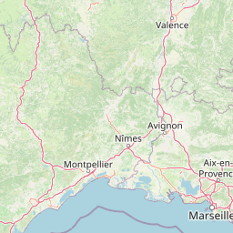
Map view of Réserve naturelle régionale de la Poitevine-Regarde-Venir

Use this park location map to pinpoint Réserve naturelle régionale de la Poitevine-Regarde-Venir in France, understand its exact geographic position, and read its mapped placement within the surrounding landscape more clearly.

Pigeon | © OpenStreetMap contributors

Location context for Réserve naturelle régionale de la Poitevine-Regarde-Venir

Provence-Alpes-Côte d'Azur
Park atlas

Compare surrounding regional reserves and connected lowland steppe habitats across Provence

Parks Near Réserve naturelle régionale de la Poitevine-Regarde-Venir and Related Protected Landscapes

Visitors exploring Réserve naturelle régionale de la Poitevine-Regarde-Venir can browse adjacent protected areas and nearby lowland reserves to understand regional ecological networks. Expanding the geographic scope reveals how similar Mediterranean dry steppe ecosystems connect across the surrounding Crau plain.
A soft watercolor illustration depicting layered rolling hills, distant mountain silhouettes, and clusters of trees in a pale color palette.
Regional parkProvence-Alpes-Côte d'Azur
About 17 km away#1 closest

Northeast

Parc naturel régional du Luberon: Regional Park Boundaries and Protected Landscape Atlas

Geology, mountain ridges, and Mediterranean ecosystems of Provence

Parc naturel régional du Luberon serves as a vital protected corridor in southeastern France. The park features three parallel limestone massifs, dramatic ochre formations, and fossil-rich plateaus. Its geography offers a case study in integrating sustainable land use with rich biodiversity across the Vaucluse and Alpes-de-Haute-Provence departments.

Area
1,747.26 km²
Established
1977
IUCN
V
Visitors
350K annual
Nature reserveProvence-Alpes-Côte d'Azur
About 19 km away#2 closest

South

Réserve naturelle régionale du Pourra - Domaine du Ranquet: Coastal Lagoon Protected Landscape

Regional Nature Reserve in Provence-Alpes-Côte d'Azur

Spanning over 300 hectares near Port-de-Bouc, this protected area preserves interconnected Mediterranean lagoons and surrounding marshlands. It offers a distinct geographic perspective on transitional coastal habitats situated within the heavily developed Bouches-du-Rhône department.

Area
3.153 km²
Established
2020
IUCN
IV
A horizontal watercolor illustration showing a marshy, grassy landscape with soft green and muted pink tones against a white background.
Regional parkProvence-Alpes-Côte d'Azur
About 20 km away#3 closest

West

Parc naturel régional de Camargue: Mapping the Rhône Delta Protected Wetland Landscape

Regional park geography and wetland conservation zones

Parc naturel régional de Camargue is a sprawling protected landscape at the confluence of the Rhône and the Mediterranean. This regional park contains significant saline lagoons, coastal dunes, and fertile marshes that serve as a crucial site for waterbird migration. Understand the interplay between traditional salt-making, pastoral ranching, and the strictly protected nature reserves that shape this delta territory.

Area
856.9 km²
Established
1970
IUCN
V
Relief
Lowland
A horizontal watercolor painting depicting a soft-focus landscape of grassy wetlands in the foreground with gentle, rolling hills in the background.
Nature reserveProvence-Alpes-Côte d'Azur
About 21 km away#4 closest

West

Réserve naturelle régionale de l'Ilon: Protected Wetland Atlas and Geographic Context

Mapping Mediterranean marshes in the Alpilles foothills.

Covering 176 hectares of diverse wetland habitat, Réserve naturelle régionale de l'Ilon preserves critical marshlands and floodable meadows. This site demonstrates the interplay between lowland water systems and the rocky Alpilles range, providing a essential refuge for diverse dragonfly and bird species within the heart of Provence.

Area
1.76 km²
Established
2012
IUCN
IV
A watercolor illustration of a tranquil marshland scene with soft green and muted pink tones, depicting reeds, sparse trees, and calm water.
Nature reserveFrance
About 31 km away#5 closest

Southwest

Réserve naturelle régionale de la Tour du Valat: Mediterranean Wetland and Research Landscape Map

A critical protected area and ecological research estate in the Rhône delta of France.

Located in the Bouches-du-Rhône department, the Réserve naturelle régionale de la Tour du Valat serves as a reference point for Mediterranean wetland science. The reserve features an intricate landscape of marshes, salt meadows, and woodland patches that support diverse birdlife and habitats. This protected area demonstrates the integration of active pastoral land use with habitat management on a significant deltaic estate near Arles.

Area
18.44 km²
Established
2008
Relief
Lowland
Climate
Mediterranean
Watercolor illustration of coastal mountains and shoreline with scattered trees
National parkBouches-du-Rhône
About 45 km away#6 closest

Southeast

Calanques National Park: Mediterranean Limestone Cliffs and Marine Protected Area

France's First Peri-Urban National Park

Calanques National Park, situated in the Bouches-du-Rhône department, represents a significant protected landscape where dramatic limestone geology meets the Mediterranean Sea. This atlas-focused entry details the park's iconic calanques, its combined terrestrial and marine protected zones, and its rich prehistoric cultural significance. Understand its unique geographic setting and its importance as a conservation area accessible for map-based discovery and regional landscape context.

Area
520 km²
Established
2012
IUCN
II
Relief
Mountain
Nature reserveProvence-Alpes-Côte d'Azur
About 45 km away#7 closest

Northeast

Réserve naturelle nationale géologique du Luberon: Geological Atlas and Protected Park Sites

Mapping Cenozoic fossil sites and limestone terrains in Provence

This protected area consists of 28 scattered sites documenting life from the Cenozoic Era through fossil-rich limestone, marl basins, and ancient lake sediments. It serves as a vital reference for field research and earth sciences, featuring rare trace fossils and mammal trackways embedded within the wider Provençal countryside.

Area
3.12 km²
Established
1987
IUCN
III
Nature reserveProvence-Alpes-Côte d'Azur
About 52 km away#8 closest

Northeast

Réserve naturelle régionale Ermitage-Escampeaux: A Protected Landscape in the Vaucluse Department

Mapping regional nature reserves within inland Provence-Alpes-Côte d'Azur.

Located in the Villes-sur-Auzon commune, the Réserve naturelle régionale Ermitage-Escampeaux stands as a significant addition to the protected lands of Provence-Alpes-Côte d'Azur. This 252.9-hectare reserve offers a focused look at the transition between Mediterranean garrigue and the higher Provençal uplands, providing essential habitat conservation within a traditional rural mosaic.

Area
2.529 km²
Established
2026
IUCN
IV

Common questions about visiting, size, designation, and location context for Réserve naturelle régionale de la Poitevine-Regarde-Venir

Réserve naturelle régionale de la Poitevine-Regarde-Venir FAQs for park facts, access, geography, and protected area context

Find quick answers about Réserve naturelle régionale de la Poitevine-Regarde-Venir, including protected-area facts, park geography, trail and visitor context, and how the park fits into its surrounding country and regional landscape.
MoriAtlas Explorer

Continue Your Protected Areas Search Across the Global Atlas

Deepen your exploration by continuing the structured search for national parks and protected areas worldwide. Utilize the comprehensive filtering capabilities to compare different conservation landscapes and refine your understanding of global park geography. Discover more about the distribution and characteristics of protected natural areas.

Global natural geography