
Mori Atlas logo
Nature reserveRéserve naturelle régionale des marais de la Taute

Tracing the mapped boundaries and marshland terrain of a vital Normandy nature reserve

Réserve naturelle régionale des marais de la Taute: Protected Wetland Geography and Map

(Réserve naturelle régionale des marais de la Taute (RNR231))

The Réserve naturelle régionale des marais de la Taute is a protected wetland landscape located within the Manche department of Normandy. This site features a complex mosaic of six separate wet meadow parcels within the broader Taute valley. Gain insight into the regional geography, the influence of historical water management on local terrain, and the protected status of these herbaceous floodplains through detailed mapping of the area.

wetlandsmarshlandbird sanctuaryregional nature reserveNormandybirdwatching
A flat, vector-style illustration of a landscape with a winding river leading to a waterfall, surrounded by trees, hills, and wetland flora under a warm, soft sun.

Réserve naturelle régionale des marais de la Taute

Nature reserve

Park overview

Structured park overview, official facts, and landscape profile for Taute Marshes Regional Nature Reserve

Taute Marshes Regional Nature Reserve park facts, protected area profile, and essential visitor context

Review the core facts for Taute Marshes Regional Nature Reserve, including designation, size, terrain, visitor scale, habitats, and operating context in one park-focused overview.

About Taute Marshes Regional Nature Reserve

The Taute Marshes Regional Nature Reserve protects a fragmented but ecologically coherent network of wet meadows along the lower Taute river, in the marshlands that historically dominated the Normandy coast inland of the Cotentin peninsula. The reserve is composed of six separate parcels of wet grassland, distributed across four communes in the Manche department. Together these parcels represent one of the more carefully managed wetland systems in western Normandy, balancing active conservation with continued traditional agricultural use.

The reserve is embedded within the much larger Marais du Cotentin et du Bessin Regional Natural Park, a landscape long shaped by centuries of peat cutting, livestock grazing, and controlled drainage. What sets the Taute Marshes apart within this broader setting is the active, bird-led management approach instituted by the Groupe ornithologique normand (GONm). Starting in the mid-1990s, the organization gradually acquired key parcels of wet meadow with the goal of restoring more natural hydrological conditions and improving breeding habitat for marshland bird species in steep decline elsewhere in Europe.

The management philosophy combines technical water-level control, careful habitat diversification through ponds and scraped margins, and contractual farming agreements with local producers. These agricultural partners are bound to late hay-cutting dates, bans on chemical inputs, and per-hectare livestock density limits, all designed to maintain the open, herbaceous character of the meadows while protecting the ground-nesting birds that depend on them. The result is a working landscape in which high-nature-value farming and conservation outcomes reinforce one another.

Although visitor access to the reserve interior is restricted in order to protect vulnerable breeding birds and sensitive plant communities, the wider landscape around it remains accessible. A discovery trail runs alongside the historic Vire and Taute canal from the Planques port between Montmartin-en-Graignes and Graignes, giving walkers and cyclists a chance to observe the marshland character of the area.

Quick facts and research context for Taute Marshes Regional Nature Reserve

The Taute Marshes Regional Nature Reserve is a 147-hectare regional nature reserve located in the Manche department of Normandy, France, established on 24 June 2011 under IUCN Category IV protection. It lies within the larger Marais du Cotentin et du Bessin Regional Natural Park, spanning the communes of Graignes, Montmartin-en-Graignes, Saint-André-de-Bohon, and Saint-Hilaire-Petitville.

Protection and recognition

Documented terrestrial protection history and designation records

Réserve Naturelle Régionale des Marais de la Taute Protection Status

Terrestrial protection status for Réserve naturelle régionale des marais de la Taute includes formal designation records established in 2011. Official conservation tracking compiles baseline metrics and administrative data without external recognition programs.

Protection details

Protection scope
Terrestrial
Designated year
2011
Transboundary protection
No
WDPA ID
555514359
Park context

Deeper park guide and search-rich context for Taute Marshes Regional Nature Reserve

Taute Marshes Regional Nature Reserve history, landscape, wildlife, and travel context

Explore Taute Marshes Regional Nature Reserve through its history, landscape character, ecosystems, wildlife, conservation priorities, cultural context, and seasonal travel timing in a structured park guide built for atlas discovery and search intent.

Why Taute Marshes Regional Nature Reserve stands out

The reserve is best known for its role as a critical nesting ground for several rare and protected marshland bird species, most notably the Eurasian bittern, the marsh harrier, and the Montagu's harrier, the latter two of which depend on the reserve as their main breeding site within the surrounding regional park. It is also nationally important as a stopover for the aquatic warbler during post-breeding migration. Equally distinctive is the reserve's mosaic of managed wet meadows sustained through custom hydraulic works that maintain a high water table well into spring, creating ideal conditions for both ground-nesting birds and rare aquatic plants such as pillwort, marsh stitchwort, and floating burr-reed. The combination of long-term habitat management by an ornithological NGO and the partnership-based farming regime makes the reserve a notable example of bird-focused wetland conservation in France.
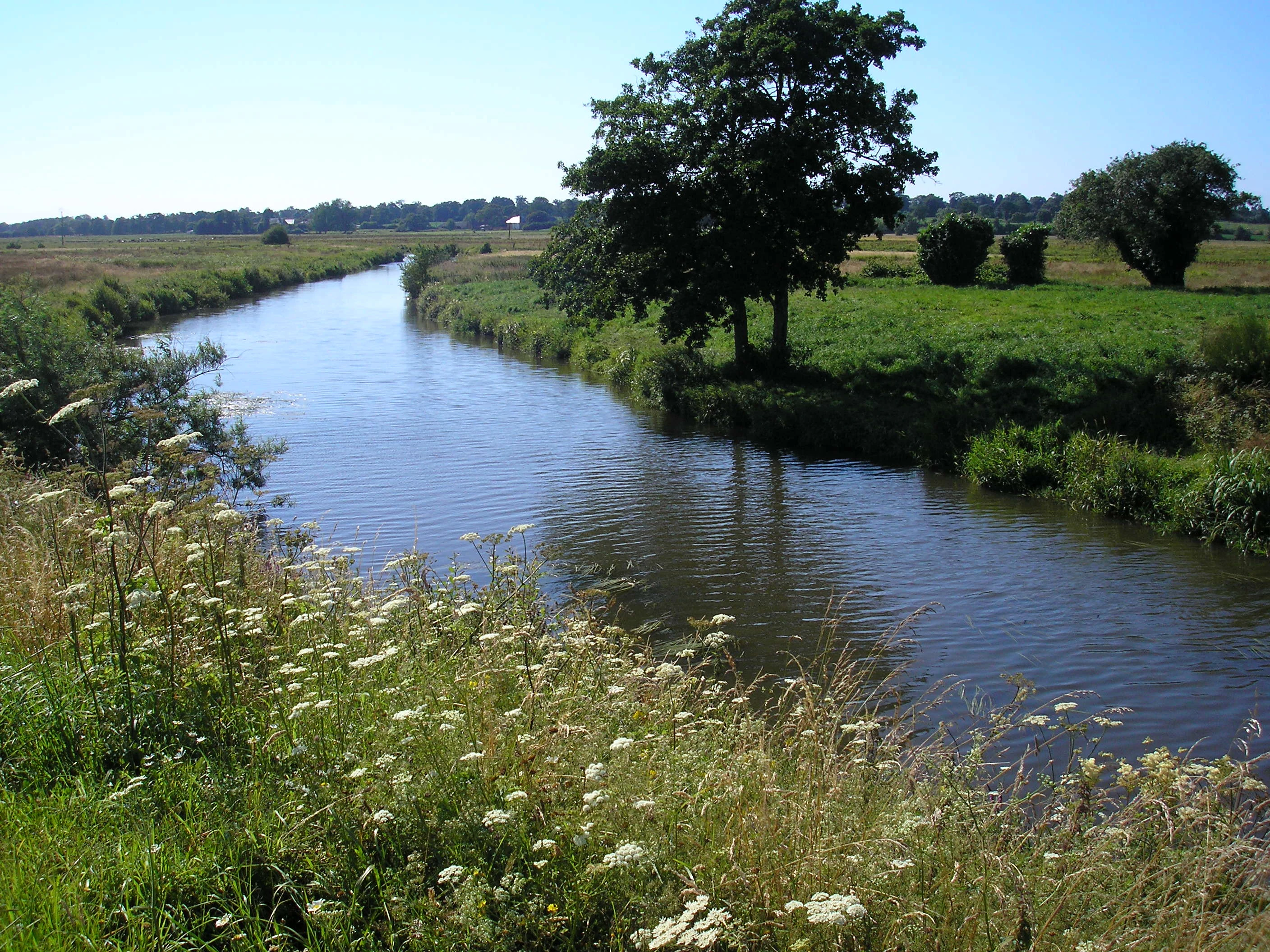
A peaceful river curves through green wetlands with wildflowers in the foreground and trees dotting the grassy banks under a clear blue sky.
The Taute River winding through the protected marshland landscape.

Taute Marshes Regional Nature Reserve history and protected-area timeline

The history of the Taute Marshes Regional Nature Reserve is closely linked to the conservation strategy of the Groupe ornithologique normand, the regional ornithological society that still owns and manages the site. Beginning in 1994, the GONm launched a deliberate program of acquiring parcels of wet meadow within the Marais du Cotentin et du Bessin Regional Natural Park, with the goal of restoring functional wetland habitat for marshland birds in an agricultural landscape where such conditions had become increasingly rare.

By the early 2010s, the organization had been managing the accumulated parcels for nearly twenty years through custom hydraulic works and contracts with local farmers. On 24 June 2011, this long-running stewardship effort received formal recognition when the site was officially classified as a regional nature reserve by the Normandy Region. The classification, designation code RNR231, consolidated the protection of what had effectively already been a managed reserve for two decades.

The reserves governance has remained closely tied to its founding organization. The first conservateur, Alain Chartier, was a vice-president of the GONm, underscoring the NGO-led model of the site. Since classification, the reserve has continued to develop its monitoring programs, agricultural partnerships, and habitat diversification work.

Taute Marshes Regional Nature Reserve landscape and geographic character

The landscape of the Taute Marshes is defined by flat, low-lying wet meadows characteristic of the historic coastal marshes of western Normandy. The reserve occupies a section of the lower Taute valley, where the river meanders through broad, herbaceous floodplain before joining the larger marshland complex that extends toward the Baie des Veys. Elevation across the reserve is uniformly very low, and the surrounding terrain is shaped as much by water management infrastructure as by natural topography.

Rather than a single continuous block, the reserve is a patchwork of six separate wetland parcels interspersed with adjacent agricultural land. This fragmented geometry is typical of marshland reserves in private ownership and reflects the incremental way the site was assembled through successive land acquisitions. Field boundaries are generally soft, marked by ditches, gentle micro-topographic changes, and variations in vegetation rather than by fences or hedges, helping to maintain a continuous open character that benefits ground-nesting birds.

The nearby Vire and Taute canal, cut in the nineteenth century to drain and transport goods through the marshlands, traces the southern edge of the reserve landscape. Its linear waterway, embankments, and elevated towpath form one of the defining physical features of the area and provide both a hydrological buffer and a route for public discovery of the broader marshland setting.

Taute Marshes Regional Nature Reserve ecosystems, habitats, and plant life

Ecologically, the Taute Marshes stand out as one of the more botanically and ornithologically diverse wet meadow systems in Normandy. The reserve supports 73 patrimonial plant species, an unusually high figure for a site of its size, reflecting both the natural fertility of the marshland soils and the careful management regime that maintains open, herbaceous conditions. Characteristic species include lesser mouse-ear, floating burr-reed, marsh trefoil, pillwort, great water-parsnip, marsh pea, marsh stitchwort, saw sedge, thread-leaved sedge, and small-reed.

Hydrology is the master variable shaping the reserves ecology. The GONm has installed an array of sluices and earthen dams designed to decouple the reserves water table from the broader drainage managed by local syndicate canals. By holding a shallow layer of standing water into late spring, the reserve creates temporary flooded meadow conditions that benefit wading birds, amphibians, and moisture-dependent plants while still allowing traditional late-summer hay production.

Habitat diversification efforts add further ecological complexity. The reserve includes scraped bare-soil patches, small ponds, and regularly cleared ditches, creating a mosaic of wet, dry, and flooded micro-habitats. This structural diversity supports a particularly rich invertebrate community, with 186 insect and arachnid species recorded, and underpins the reserves value for amphibians such as the European tree frog and the common frog.

Taute Marshes Regional Nature Reserve wildlife and species highlights

Wildlife is the defining focus of the Taute Marshes Regional Nature Reserve, and the site is fundamentally a bird reserve. A total of 140 bird species have been recorded, but the reserves significance lies less in this overall figure than in the concentration of breeding species of high conservation concern that depend on it.

Key breeding species include the Eurasian bittern, the marsh harrier, and the Montagu's harrier; for all three, the reserve hosts the largest share of territorial pairs within the surrounding regional park, generally more than a third of the population. Other regular breeders include garganey, northern shoveler, gadwall, Eurasian curlew, northern lapwing, spotted crake, water rail, bluethroat, Savi's and grasshopper warblers, whinchat, yellow wagtail, sedge warbler, and reed bunting. The post-breeding migration period brings nationally significant numbers of the rare aquatic warbler to the site as a stopover.

In winter, the reserve holds several hundred common snipe, smaller numbers of jack snipe, and overwintering bitterns, while a communal roost of hen harriers and marsh harriers is a regular feature. Mammals are less conspicuous but include at least 15 species, notably the stoat and the water vole. Reptiles are scarce, but grass snake and common lizard occur locally, while the white stilted grasshopper, when abundant in midsummer, supports concentrations of white storks, common buzzards, and common kestrels feeding on the marsh.

Taute Marshes Regional Nature Reserve conservation status and protection priorities

The Taute Marshes reserve embodies a long-term, NGO-led model of wetland conservation in an agricultural setting. Its principal conservation value lies in providing secure breeding habitat for several marshland bird species that have suffered severe declines across much of their European range, including the Eurasian bittern, marsh harrier, and Montagu's harrier. The reserves protected status and tailored management help to anchor a meaningful share of the regional population of each of these species within the surrounding Marais du Cotentin et du Bessin.

A second major contribution is the reserves role along the migratory flyway. The maintenance of shallow spring flooding followed by structured summer hay-making produces the precise sward structure that the aquatic warbler requires during its post-breeding stopover in western France, making the site part of a small national network of strongholds for this globally threatened passerine.

Conservation management itself is structured around three pillars: independent control of internal water levels, active diversification of habitats through small-scale earthworks and ditch management, and contractual relationships with local farmers. Agricultural contracts impose permanent grassland status, ban synthetic fertilizers and pesticides, set late cutting dates after 25 July, and cap grazing pressure, while environmental leases provide additional long-term security. This combination of hydrological control, habitat engineering, and farmer partnership is a defining feature of the reserves conservation model.

Taute Marshes Regional Nature Reserve cultural meaning and human context

The Taute Marshes sit within a rural landscape that has long been shaped by human management. Wet meadows of this kind have supported livestock farming and hay production for centuries, and the surrounding Cotentin marshlands preserve one of the most extensive traditional meadow landscapes in north-western France. The reserves agricultural contracts explicitly maintain this working-marsh character, making conservation and continuity of traditional land use mutually reinforcing rather than opposed.

The nearby Vire and Taute canal, a nineteenth-century engineering project, is a reminder of the long history of human intervention in draining and organizing these marshes. Its enduring presence, repurposed today as a focus for walking and a public discovery trail, links the reserves ecological story to the broader cultural and economic history of the Norman marshlands.

Top sights and standout views in Taute Marshes Regional Nature Reserve

The reserves six separately managed wetland parcels each contribute distinct habitat conditions, while the systematic flooding management in spring is what makes the marshland bird breeding community possible. The GONm-led acquisition and protection history since 1994, predating formal classification by nearly two decades, gives the site institutional continuity that is unusual for small reserves of this kind.

Visitors without direct reserve access can still encounter the marshland atmosphere through the discovery trail along the Vire and Taute canal at the Planques port, connecting the reserve to a broader regional walking and cycling network.

Best time to visit Taute Marshes Regional Nature Reserve

Spring is the most ecologically expressive season in the Taute Marshes, when deliberate flooding produces a shallow, reflective sheet of water across the meadows and breeding marshland birds such as bitterns, harriers, and curlews become most vocal and visible. Late spring and early summer also coincide with the flowering peak of several patrimonial plant species, including the marsh stitchwort, saw sedge, and small-reed, though public access to the reserve itself remains restricted in this period to protect nesting birds.

Late summer and early autumn are quieter but scenically attractive, as contracted farmers carry out the required late hay cuts and migratory warblers move through the surrounding marshlands on their way south. In winter, the reserve hosts large numbers of common snipe and a regular harrier roost, and from the public discovery trail along the Vire and Taute canal the broader marshland landscape takes on a calm, open character favored by visiting birdwatchers and walkers.

Monthly climate preview

Long term monthly temperature and precipitation averages derived from representative point coordinates

Climate Normals and Annual Temperature Rhythm for Réserve naturelle régionale des marais de la Taute

Representative coordinate records show average monthly temperatures ranging from 6.66 °C to 17.82 °C alongside varying precipitation rates across the annual cycle. Reviewing the complete twelve month climate profile reveals detailed monthly fluctuations and long term meteorological patterns.
Annual mean12 °C
7 °C18 °C
Jan
Feb
Mar
Apr10°
May12°
Jun15°
Jul17°
Aug18°
Sep16°
Oct14°
Nov10°
Dec
Warmest month
August

17.8 °C

Coolest month
February

6.7 °C

Wettest month
December

3.2 mm/day

Driest month
July

1.5 mm/day

Park location guide

Geography guide, regional context, and park location map for Taute Marshes Regional Nature Reserve

Taute Marshes Regional Nature Reserve park geography, regions, and map view in France

Understand where Taute Marshes Regional Nature Reserve sits in France through a broader geographic reading of the surrounding landscape, nearby location context, and its mapped position within the national park landscape.

How Taute Marshes Regional Nature Reserve fits into France

France is a unitary semi-presidential republic and one of the world's largest economies. It borders Belgium, Luxembourg, Germany, Switzerland, Italy, Monaco, Andorra, and Spain, with a maritime border to the United Kingdom. The country is known for its cultural influence, art, cuisine, and political history spanning centuries.

Wider geography shaping Taute Marshes Regional Nature Reserve in France

France is located in Western Europe. Metropolitan France extends from the Rhine to the Atlantic Ocean and from the Mediterranean Sea to the English Channel and North Sea. The country borders Belgium, Luxembourg, Germany, Switzerland, Italy, Monaco, Andorra, Spain, and has a maritime border with the United Kingdom.

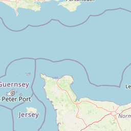
Map view of Taute Marshes Regional Nature Reserve

Use this park location map to pinpoint Taute Marshes Regional Nature Reserve in France, understand its exact geographic position, and read its mapped placement within the surrounding landscape more clearly.

Pigeon | © OpenStreetMap contributors

Location context for Taute Marshes Regional Nature Reserve

Manche

Photographic records of wet meadows, marshland habitats, and protected terrain in Normandy

Explore Visual Landscapes and Scenery of Réserve naturelle régionale des marais de la Taute

Visual documentation captures the flat herbaceous floodplains and managed wetland parcels defining the protected landscape. Detailed photography reveals the subtle micro-topography and canal corridors supporting rare marshland birds across the valley.

A peaceful river curves through green wetlands with wildflowers in the foreground and trees dotting the grassy banks under a clear blue sky.

Park atlas

Compare adjacent protected landscapes, regional valley reserves, and coastal marsh habitats in Normandy.

Explore Parks Near Réserve naturelle régionale des marais de la Taute and Surrounding Wetlands

Browse protected areas and wetland reserves situated close to Réserve naturelle régionale des marais de la Taute across the western Normandy lowlands. Comparing nearby regional parks reveals broader hydrological patterns, floodplain geography, and interconnected bird conservation zones.
A minimalist watercolor painting of soft green hills and light patches of color against a plain white background.
Nature reserveNormandie
About 24 km away#1 closest

East

Réserve naturelle nationale de la forêt domaniale de Cerisy: A Normandy Protected Area

Ecological landscape and forest geography in France

Situated across the Calvados and Manche departments, this nature reserve protects a substantial beech-dominated state forest. The site provides a unique opportunity to study woodland ecosystems, endemic beetle conservation, and the transition between dense forest interiors and the surrounding Norman bocage landscape.

Area
21.24 km²
Established
1976
IUCN
IV
Relief
Upland
A soft watercolor painting of a serene natural landscape featuring foreground grasses, a small body of water, a grassy shoreline, coniferous trees, and hazy hills in the background.
Nature reserveNormandie
About 59 km away#2 closest

East

Réserve naturelle nationale de la falaise du Cap-Romain: Coastal Nature Reserve Map

Explore protected maritime cliffs and Jurassic fossil sites in Calvados, France.

The Réserve naturelle nationale de la falaise du Cap-Romain stands as a compact but rich geological archive on the Côte de Nacre. It protects maritime cliffs, rocky tidal platforms, and significant Bathonian-age sponge fossil reefs. This site offers deep insights into the region's Quaternary history, encompassing glacial deposits, loess layers, and diverse marine fossil assemblages.

Area
0.24 km²
Established
1984
IUCN
III
A horizontal watercolor painting showing a marshy wetland area with grassy foreground, a central pond, and soft green rolling hills in the distance.
Nature reserveNormandie
About 61 km away#3 closest

Northwest

Réserve naturelle nationale de la mare de Vauville: Coastal Lagoon and Dune Protected Area

Normandie coastal geography and wetland mapping

This protected area captures the distinct intersection of granite massifs, sandstone substrates, and active coastal dunes. The reserve features a shallow, elongated freshwater pond sheltered by a fragile dune cord, providing essential habitat for migratory waterfowl and amphibians within a concentrated coastal geography.

Area
0.603 km²
Established
1976
IUCN
IV
Watercolor painting of a river flowing through a valley with gentle green hills and trees on the banks.
Nature reserveCalvados
About 67 km away#4 closest

Southeast

Rochers des Parcs Nature Reserve: A Detailed Atlas and Protected Landscape Overview

Geographic boundaries and cliff terrain in Calvados, Normandy.

The Rochers des Parcs nature reserve features dramatic Cambrian conglomerate cliffs rising above the Orne river in the Calvados department. This site is defined by its steep wooded slopes, rare plant species, and established network of hiking paths. It represents a vital area of conservation, protected for its geological interest and ecological value, providing a clear window into the rugged terrain of the Suisse normande landscape.

Area
0.36 km²
Established
1977
Relief
Upland
Scope
Terrestrial
A soft watercolor illustration of a green wetland area with rolling hills and misty silhouettes in the background, set against a white background.
Nature reserveBretagne
About 86 km away#5 closest

South

Réserve naturelle régionale du marais de Sougeal: Regional Wetland and Protected Landscape in Bretagne

A managed floodplain sanctuary near the Bay of Mont-Saint-Michel

Located in the Ille-et-Vilaine department, this regional nature reserve preserves a unique strip of wet grassland and flood-prone meadows. Use our mapping data to understand the park's specific terrain, from its narrow channel systems to its role as a key stopover for migratory waterbirds and a communal grazing area in the heart of Bretagne.

Area
1.74 km²
Established
2006
IUCN
IV
Relief
Lowland
A horizontal watercolor painting depicting a soft-toned landscape with a rocky scree slope in the foreground and rolling hills under a pastel sunset sky.
Nature reserveNormandie
About 98 km away#6 closest

Southeast

Réserve naturelle régionale des pierriers de Normandie: Geographic Scree Slope Atlas

Examining rocky protected terrain in Normandy, France

The Réserve naturelle régionale des pierriers de Normandie protects one of the most distinctive natural scree slopes in northwestern Europe. This site preserves fragile rocky debris fields that support specialized vegetation and invertebrate communities. Our atlas data offers a close look at the boundaries and geological character of this significant protected landscape in the Orne department.

Area
0.009 km²
Established
2018
IUCN
IV
Scope
Terrestrial
Nature reservePays de la Loire
About 108 km away#7 closest

South

Réserve naturelle régionale des prairie et boisement humides des Bizeuls: Regional Nature Reserve Atlas

Wetland habitat preservation in the Mayenne department of western France.

This reserve provides a compact, ecologically dense mosaic of wet meadows and wet woodland in the Pays de la Loire region. It serves as a vital protected area for maintaining wetland biodiversity within a predominantly agricultural landscape, offering a precise look at the terrain and hydrological features characteristic of western France.

Area
0.044 km²
Established
2019
IUCN
IV
A pale watercolor landscape painting showing rolling green hills and distant mountain ridgelines against a white background.
Nature reservePays de la Loire
About 118 km away#8 closest

Southeast

Réserve naturelle régionale Mont des Avaloirs: Protected Landscape and Geographic Overview

Upland heath and summit geography of the Armorican Massif

Investigate the unique physical geography of Réserve naturelle régionale Mont des Avaloirs. This area acts as a biodiversity stronghold in northwestern France, defined by a dramatic interplay of stony blockfields, sheltered valley brooks, and protected peatland basins that create atypical ecological conditions across the Mayenne countryside.

Area
3.211 km²
Established
2020
IUCN
IV
Relief
Mountain

Common questions about visiting, size, designation, and location context for Taute Marshes Regional Nature Reserve

Taute Marshes Regional Nature Reserve FAQs for park facts, access, geography, and protected area context

Find quick answers about Taute Marshes Regional Nature Reserve, including protected-area facts, park geography, trail and visitor context, and how the park fits into its surrounding country and regional landscape.
MoriAtlas Explorer

Continue Your Protected Areas Search Across the Global Atlas

Deepen your exploration by continuing the structured search for national parks and protected areas worldwide. Utilize the comprehensive filtering capabilities to compare different conservation landscapes and refine your understanding of global park geography. Discover more about the distribution and characteristics of protected natural areas.

Global natural geography