Mori Atlas logo
Nature reserveRiserva naturale garzaia di Porta Chiossa

Mapping the ecological boundaries and historic landscape context of this Pavese plain nature reserve

Riserva naturale garzaia di Porta Chiossa: A Protected Lowland Forest and Heronry in Lombardia

(Riserva Regionale Garzaia di Porta Chiossa)

The Riserva naturale garzaia di Porta Chiossa protects a vital eighty hectare fragment of lowland woodland in the Po Plain of Lombardy. As a designated Site of Community Importance, the reserve sustains a mature canopy of alder, oak, and willow that serves as a critical nesting ground for mixed heron colonies. This area preserves a rare visual and ecological continuity with the medieval Visconti hunting park, standing as a distinct natural stronghold amidst the modern agricultural landscape of the Pavia province.

lowland forestplaniziale woodlandheronrygarzaiawet woodlandbird sanctuary

Riserva naturale garzaia di Porta Chiossa

Nature reserve

Park overview

Structured park overview, official facts, and landscape profile for Riserva Naturale Garzaia di Porta Chiossa

Riserva Naturale Garzaia di Porta Chiossa park facts, protected area profile, and essential visitor context

Review the core facts for Riserva Naturale Garzaia di Porta Chiossa, including designation, size, terrain, visitor scale, habitats, and operating context in one park-focused overview.

About Riserva Naturale Garzaia di Porta Chiossa

The Riserva Naturale Garzaia di Porta Chiossa sits in the heart of the Po Plain, in the immediate outskirts south of Pavia, where the surrounding countryside is dominated by rice paddies, maize fields and rows of planted poplars. Within this intensively farmed landscape, the reserve preserves a rare fragment of the original planiziale forest that once covered much of the plain. Two main woodland formations characterise the site: hygrophilous lowland woods where grey alders thrive especially near spring fed seepage points, and mixed stands of white willow, white poplar and pedunculate oak that mark slightly drier ground. The tallest trees commonly exceed twenty meters in height, creating a dense canopy that shelters one of the most important mixed heron colonies in the Pavese plain.

The reserve's geographic position at the southern edge of the historic Visconti domain gives it a cultural dimension as well. Together with the Parco della Vernavola and the Garzaia della Carola, it forms part of the surviving green skeletal remains of the great 14th century hunting and pleasure park commissioned by Galeazzo II Visconti beginning in 1366. That medieval park, walled and provided with towers and fortified gates, once linked the Visconti Castle in Pavia to the Certosa di Pavia. The reserve's own name is taken from porta Chiossa, one of those historic gates.

Ecologically, the site matters because the Po Plain retains only isolated patches of true lowland forest, and many of these are small and fragmented. By protecting the hydrology and tree cover over eighty hectares, the reserve maintains a nesting refuge for colonial waterbirds that would otherwise struggle to find suitable sites in the surrounding agricultural matrix. The Province of Pavia is the managing authority, and the area has been formally integrated into the European Natura 2000 network both as a Site of Community Importance and as a Special Protection Area under the Birds Directive.

Quick facts and research context for Riserva Naturale Garzaia di Porta Chiossa

The reserve lies in the comuni of San Genesio ed Uniti and Sant'Alessio con Vialone in the Province of Pavia, Lombardy. It covers around 80 hectares and was established in 1984 as a regional natural reserve. It is listed in the World Database on Protected Areas under WDPA code 64461 and in Italy's official register of protected areas under EUAP0303. The site is classified as an IUCN Category IV protected area, recognising its focus on the conservation of specific habitats and species. It is simultaneously a Site of Community Importance (SIC IT2080017) and a Special Protection Area under the EU Birds Directive.

Protection and recognition

Examine the official protected area designation and registry data

Riserva naturale garzaia di Porta Chiossa Protection Status and Records

Riserva naturale garzaia di Porta Chiossa holds registered protected area records within the global database index. Conservation researchers review these documented status details and registry entries for structural geographic analysis.

Protection details

WDPA ID
64461
Park context

Deeper park guide and search-rich context for Riserva Naturale Garzaia di Porta Chiossa

Riserva Naturale Garzaia di Porta Chiossa history, landscape, wildlife, and travel context

Explore Riserva Naturale Garzaia di Porta Chiossa through its history, landscape character, ecosystems, wildlife, conservation priorities, cultural context, and seasonal travel timing in a structured park guide built for atlas discovery and search intent.

Why Riserva Naturale Garzaia di Porta Chiossa stands out

The reserve is best known for its mixed colonies of night herons and grey herons nesting among the floodplain trees, the very feature from which Italian reserves of this type take the name "garzaia." It is also notable as one of the last surviving fragments of the medieval Visconti hunting park that once stretched from Pavia toward the Certosa di Pavia, a landscape otherwise almost entirely converted to rice fields, maize and poplar plantations. The combination of ancient woodland character, breeding heronry, and historical Visconti heritage gives the reserve a distinctive identity within the Po Plain.
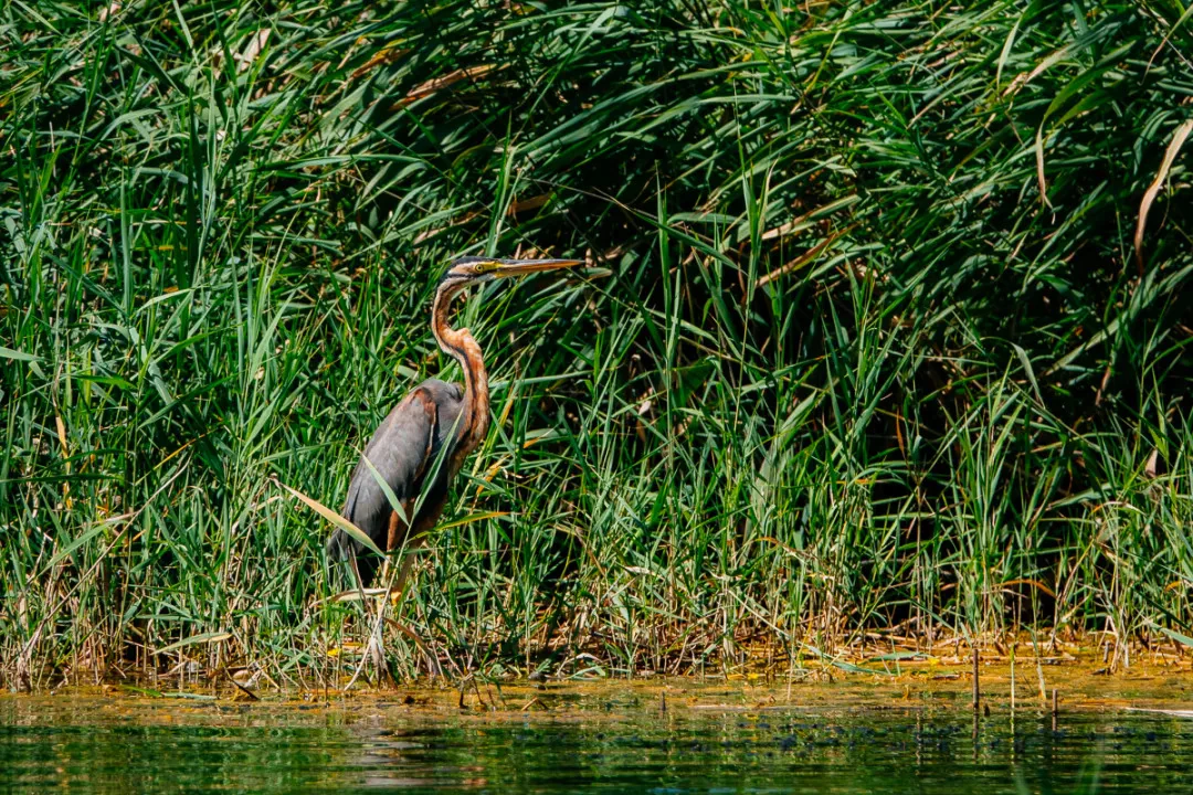
A purple heron with a long neck and pointed beak stands at the edge of a body of water, surrounded by tall green reeds and grasses.
A purple heron stands at the water's edge among tall reeds in the Garzaia di Porta Chiossa nature reserve.

Riserva Naturale Garzaia di Porta Chiossa history and protected-area timeline

The landscape that the reserve protects is far older than its formal protection. From 1366, Galeazzo II Visconti set in motion the creation of a vast walled park that would link the Visconti Castle of Pavia to the Certosa di Pavia, enclosed by walls, towers and fortified gates. Portions of that medieval royal park, including the woodland and wetland fabric around the gate known as porta Chiossa, survived centuries of agricultural transformation and urban expansion, ultimately becoming one of the few wooded enclaves remaining within the Pavese plain.

The reserve itself was formally established in 1984 by regional decree, recognising both the ecological and historical value of the surviving woodland and its importance as a breeding site for herons. It was subsequently included in the European Natura 2000 network, designated both as a Site of Community Importance under the Habitats Directive and as a Special Protection Area under the Birds Directive. These recognitions underline the reserve's role not just as a local sanctuary but as part of the wider European framework for protecting threatened habitats and migratory bird populations.

Riserva Naturale Garzaia di Porta Chiossa landscape and geographic character

The reserve lies on the flat alluvial floor of the Po Plain, a landscape from which any substantial woodland stand stands out immediately against the surrounding agricultural land. The terrain is level, with subtle variation driven by the presence of risorgive, the natural springs and resurgent water seepages that surface along this stretch of the plain. Where these springs emerge, the ground remains damp enough to support alder woodland, while elsewhere the soils are slightly drier and carry mixed stands of willow, poplar and oak. The tallest trees can exceed twenty metres, giving the canopy a closed, mature character that is unusual so close to Pavia.

Encircling the reserve, the agricultural matrix of the Po Plain is dominated by rice paddies, maize fields and poplar plantations. Hydraulic works on these surrounding fields have over time lowered the water table, drying out parts of the historical forest and shifting the balance between species. The result is a transitional woodland landscape in which alder is increasingly restricted to the wettest seepage areas, while oak has begun to expand into the drier zones.

Riserva Naturale Garzaia di Porta Chiossa ecosystems, habitats, and plant life

The reserve's nature is defined by its status as one of the few surviving examples of hygrophilous planiziale forest in the Po Plain. The principal tree layer is dominated by white willow (Salix alba), white poplar (Populus alba) and, especially in the wetter spring zone, black alder (Alnus glutinosa), with more limited presence of pedunculate oak (Quercus robur). Mature specimens of alder commonly exceed twenty metres in height, contributing to the structural complexity of the canopy. The understorey is sparse in the densest alder stands but becomes more visible in transitional areas, with elder (Sambucus nigra) and bramble (Rubus ulmifolius) forming the principal shrub layer.

At ground level, the herbaceous flora reflects the damp, shaded character of the forest. Enchanter's nightshade (Circaea lutetiana), horsetails (Equisetum spp.), pellitory-of-the-wall (Parietaria officinalis), stinging nettle (Urtica dioica), ivy (Hedera helix), curled dock (Rumex crispus), common horsetail (Equisetum arvense), a sedge (Carex brizoides), common reed (Phragmites australis) and bittersweet (Solanum dulcamara) are among the characteristic species. The combination produces a humid, lush ground layer typical of lowland alluvial woods and adds to the ecological significance of a site that lies within an otherwise heavily cultivated landscape.

Riserva Naturale Garzaia di Porta Chiossa wildlife and species highlights

The defining feature of the reserve is its mixed heronry, the colonial breeding aggregation of wading birds that gives Italian garzaie their name. Night herons (Nycticorax nycticorax) and grey herons (Ardea cinerea) are the most prominent colony formers, nesting in the canopy of the floodplain trees and using the surrounding rice paddies and wet woodland as foraging habitat during the breeding season. The birdlife extends more broadly across many species that find refuge in the canopy and along the woodland edges, contributing to the reserve's formal recognition as a Special Protection Area under the European Birds Directive.

Riserva Naturale Garzaia di Porta Chiossa conservation status and protection priorities

From a conservation perspective, the reserve is significant because it preserves a habitat, planiziale hygrophilous forest with mature alder, willow and poplar stands, that has been almost entirely lost from the Po Plain. By holding a continuous wooded block of roughly eighty hectares in a landscape otherwise given over to rice, maize and poplar cultivation, it provides both a breeding refuge for colonial waterbirds and a reservoir of lowland forest biodiversity. Its formal designation as a Natura 2000 Site of Community Importance and a Special Protection Area reflects this regional and European importance.

The reserve also illustrates the conservation challenge of managing lowland forest remnants in an active agricultural setting. Hydraulic changes in surrounding farmland have lowered the water table over recent decades, leading to gradual drying of the soil and a shift in tree species composition, with alder retreating to the wettest spring fed areas while oak has expanded into drier zones. Management by the Province of Pavia therefore has to balance protection of the heronry and of the native hygrophilous forest against continuing external hydrological pressures.

Riserva Naturale Garzaia di Porta Chiossa cultural meaning and human context

Beyond its ecological value, the reserve carries a meaningful cultural dimension as a surviving fragment of the Visconti park of Pavia. The medieval park commissioned by Galeazzo II from 1366 was a grand, walled hunting and pleasure landscape stretching from the Visconti Castle of Pavia to the Certosa di Pavia, complete with towers and fortified gates. Almost all of that landscape has since been transformed by agriculture and urban growth, and only a few wooded fragments remain. The reserve's name itself, taken from porta Chiossa, preserves the memory of one of the original gates. Together with the nearby Parco della Vernavola and the Garzaia della Carola, the reserve forms one of the few living links between the modern Pavese plain and its medieval Visconti past.

Top sights and standout views in Riserva Naturale Garzaia di Porta Chiossa

Among its distinguishing features, the reserve offers the rare combination of an active mixed heronry, mature lowland floodplain woodland, and direct historical continuity with one of Lombardy's most important medieval park landscapes. It is one of only three surviving wooded fragments of the historic Visconti park, alongside the Parco della Vernavola and the Garzaia della Carola, and as such carries significance well beyond its modest size. Its double designation as a Natura 2000 Site of Community Importance and a Special Protection Area underlines its role in European conservation networks.

Best time to visit Riserva Naturale Garzaia di Porta Chiossa

The most rewarding time to experience the reserve is during the spring and early summer breeding season of the heron colony, when night herons and grey herons are active around their nests in the canopy and when the surrounding rice paddies flood, providing rich foraging conditions for wading birds. Late spring also brings the most luxuriant expression of the herbaceous woodland layer, while autumn offers quieter birdwatching conditions and crisp views across the canopy. Summer visits are best in the cooler hours of the day, since the reserve is a lowland site with little shade outside the forest interior.

Monthly climate preview

Long-term representative point measurements tracking annual temperature and precipitation patterns

Riserva naturale garzaia di Porta Chiossa climate normals and temperature rhythms

Historical data records mean monthly temperatures ranging from 2.43 degrees Celsius to 23.87 degrees Celsius alongside recorded daily precipitation values across the coordinate. Reviewing the full twelve-month profile reveals complete monthly averages and detailed precipitation distributions for the protected area.
Annual mean13 °C
2 °C24 °C
Jan
Feb
Mar
Apr12°
May16°
Jun21°
Jul24°
Aug24°
Sep19°
Oct13°
Nov
Dec
Warmest month
July

23.9 °C

Coolest month
January

2.4 °C

Wettest month
November

4 mm/day

Driest month
July

1.4 mm/day

Park location guide

Geography guide, regional context, and park location map for Riserva Naturale Garzaia di Porta Chiossa

Riserva Naturale Garzaia di Porta Chiossa park geography, regions, and map view in Italy

Understand where Riserva Naturale Garzaia di Porta Chiossa sits in Italy through a broader geographic reading of the surrounding landscape, nearby location context, and its mapped position within the national park landscape.

How Riserva Naturale Garzaia di Porta Chiossa fits into Italy

Italy is a unitary parliamentary republic in Southern and Western Europe, located on the Italian Peninsula with the Alps to the north. It borders France, Switzerland, Austria, Slovenia, Vatican City, and San Marino, and shares maritime boundaries with several Mediterranean countries. The country has approximately 59 million residents and uses the Euro as its currency.

Wider geography shaping Riserva Naturale Garzaia di Porta Chiossa in Italy

Italy occupies a boot-shaped peninsula in southern Europe, bordered by the Alps to the north. It shares land borders with France, Switzerland, Austria, Slovenia, Vatican City, and San Marino. The country includes the Mediterranean islands of Sicily and Sardinia, along with approximately 800 smaller islands.

Map view of Riserva Naturale Garzaia di Porta Chiossa

Use this park location map to pinpoint Riserva Naturale Garzaia di Porta Chiossa in Italy, understand its exact geographic position, and read its mapped placement within the surrounding landscape more clearly.

Pigeon | © OpenStreetMap contributors

Location context for Riserva Naturale Garzaia di Porta Chiossa

Lombardia

Visualizing the rare lowland woodland habitats and protected riverine terrain

Riserva naturale garzaia di Porta Chiossa Photos and Landscape Scenery

Visual documentation captures the mature floodplain canopy and damp planiziale woodland environments preserved within the reserve. Examining these protected habitats clarifies how natural spring seepages support rare colonial waterbirds across the surrounding agricultural plain.

A purple heron with a long neck and pointed beak stands at the edge of a body of water, surrounded by tall green reeds and grasses.

Park atlas

Compare adjacent protected areas, lowland woodlands, and regional reserves across the Po Plain.

Explore Parks Near Riserva Naturale Garzaia di Porta Chiossa and Surrounding Landscapes

Browse other protected areas and lowland woodland fragments situated across the surrounding Po Plain region. Expanding beyond Riserva naturale garzaia di Porta Chiossa reveals connected conservation landscapes and regional park networks.
Nature reservePiemonte
About 66 km away#1 closest

West

Riserva naturale speciale dell'Isolone di Oldenico: Geography and Riverine Conservation Atlas

Protected riparian corridors in the Po Plain region of Northern Italy

This nature reserve preserves a distinct island feature formed by the Sesia river system. As a vital component of the lower Sesia valley network, the protected area contrasts sharply with the surrounding agricultural land by maintaining indigenous riverine vegetation, marshy habitat pockets, and natural levees within the flat terrain of the Province of Vercelli.

Area
0.52 km²
Established
1978
IUCN
IV
A horizontal watercolor painting showing rolling green hills, a forest line, and faint pinkish mountains in the distance against a white background.
Nature reserveLombardia
About 66 km away#2 closest

North

Riserva naturale Valle Bova: An Atlas Guide to Lombardia's Protected River Valley

Karst geology, gorge terrain, and pre-Alpine forest ecosystems

This protected area centers on the Bova stream valley, a significant geological enclave featuring the Buco del Piombo cave and the Orrido di Caino fissure. The reserve terrain demonstrates the complex relationship between northern Italian river systems and pre-Alpine mountain slopes, providing a distinct geographic profile for hikers and regional researchers alike.

Area
3.91 km²
Established
2007
IUCN
IV
Relief
Upland
Watercolor painting of a calm lake surrounded by rolling hills and soft greenery.
Nature reserveLombardia
About 89 km away#3 closest

North

Lago di Piano Nature Reserve: Glacial Geography and Protected Wetland Landscapes

Protected marshland basin in the Lombardy pre-Alps

Lago di Piano sits as a rare lowland wetland oasis carved by ancient glacial activity in the Lombardy foothills. This reserve preserves a complex network of floating vegetation, reed beds, and drumlin-framed valleys, providing a vital study of pre-Alpine geography and protected-area conservation within northern Italy.

Area
0.72 km²
Relief
Lowland
Climate
Temperate
Access
Easy access
Watercolor illustration of stylized rolling green mountains and a treeline in shades of green, pink, and soft yellow.
Nature reserveEmilia-Romagna
About 93 km away#4 closest

Southeast

Monte Prinzera Nature Reserve: Emilia-Romagna Protected Ophiolite and Geological Atlas

Ancient oceanic crust and rare ecological habitats

Monte Prinzera represents a singular geological anomaly in the Apennine foothills, characterized by its deep rust-red color and specialized dry Mediterranean vegetation. As the only protected ophiolite site in Emilia-Romagna, the reserve offers essential insight into ultramafic ecology, hosting a mosaic of mixed deciduous woodlands and xerophilous grasslands that support unique populations of birds, bats, and mammals.

Established
1990
Relief
Mountain
Scope
Terrestrial
Water
Minor water
Nature reserveEmilia-Romagna
About 93 km away#5 closest

East

Riserva naturale di Torrile e Trecasali: Protected Wetland Geography in Emilia-Romagna

A regional nature reserve and migratory bird sanctuary

Located in the lowlands of the Po Valley, Riserva naturale di Torrile e Trecasali protects a concentrated variety of freshwater habitats. From reed-fringed canals to seasonal flood meadows, this site provides essential mapping context for understanding lowland riparian corridors and their role in regional biodiversity within northern Italy.

Area
1.09 km²
Established
2010
IUCN
IV
Watercolor illustration showing green mountains, forests, a river, and snow-capped peaks in the distance
National parkPiedmont
About 94 km away#6 closest

Northwest

Val Grande National Park: National Park Protected Landscape in Piedmont

Explore its mapped boundaries and regional geographic context.

Val Grande National Park represents a key protected landscape within the Piedmont region of northwest Italy. This canonical page offers detailed insights into the park's designated status as a national park, its specific geographic placement, and its mapped protected boundaries. Users can navigate its atlas-level details to understand its role in the regional geography and conservation landscape, providing a structured foundation for further discovery of Italy's natural protected areas.

Area
170.21 km²
Established
1992
IUCN
II
Relief
Mountain
A watercolor painting showing a soft-focus, panoramic landscape with green trees, gentle hills, a central body of water, and pale mountains in the background against a white backdrop.
Nature reserveBiella
About 94 km away#7 closest

West

Riserva naturale speciale della Bessa: Protected Nature Reserve in Northern Piedmont

Glacial moraines and archaeological mining landscapes near Biella

Located in the foothills of the Alps, the Riserva naturale speciale della Bessa is defined by its austere, stone-filled plateau. This nature reserve offers a unique look at Pleistocene glacial deposits and the extensive traces of Roman placer gold extraction. The geography includes erratic boulders, deep erosional channels, and historic terrace systems that reveal a deep connection between ancient labor and natural geological forces.

Area
7.5 km²
Established
2009
IUCN
IV
Marine protected areaFrance
About 94 km away#8 closest

South

Sanctuaire Pelagos Marine Protected Area: Mediterranean Geography and Seascape

A transboundary conservation zone spanning 87,500 square kilometers.

Sanctuaire Pelagos represents a unique collaborative effort in marine conservation across the Mediterranean. Spanning the waters between France, Italy, and Monaco, this protected maritime area is defined by its deep-sea canyons and nutrient-rich currents that sustain diverse cetacean populations. Its immense scale and international governance make it a focal point for understanding Mediterranean marine biodiversity and environmental policy.

Area
87,500 km²
Established
1999
IUCN
IV
Relief
Lowland

Common questions about visiting, size, designation, and location context for Riserva Naturale Garzaia di Porta Chiossa

Riserva Naturale Garzaia di Porta Chiossa FAQs for park facts, access, geography, and protected area context

Find quick answers about Riserva Naturale Garzaia di Porta Chiossa, including protected-area facts, park geography, trail and visitor context, and how the park fits into its surrounding country and regional landscape.
MoriAtlas Explorer

Continue Your Protected Areas Search Across the Global Atlas

Deepen your exploration by continuing the structured search for national parks and protected areas worldwide. Utilize the comprehensive filtering capabilities to compare different conservation landscapes and refine your understanding of global park geography. Discover more about the distribution and characteristics of protected natural areas.

Global natural geography