Mori Atlas logo
National parkRussian Arctic National Park

Mapping the Northernmost Russian Archipelagos, Glaciers, and Marine Mammal Habitats

Russian Arctic National Park: A Protected Arctic Landscape of Global Significance

(National Park Russian Arctic)

Russian Arctic National Park represents a vast expanse of Russia's most remote and northerly wilderness, safeguarding critical Arctic ecosystems across the Novaya Zemlya and Franz Josef Land archipelagos. This protected area, encompassing expansive terrestrial and marine environments, offers a unique lens into Arctic geography, preserving vital habitats for polar bears, bowhead whales, and millions of seabirds. Discover the park's dramatic glacial landscapes, volcanic terrain, and the vital role it plays in global Arctic conservation through detailed map exploration.

Arctic wildernessMarine protected areaPolar bear habitatGlacier landscapeBird coloniesFranz Josef Land
Stylized illustration of a mountainous landscape with a waterfall, river, and coniferous forest under a partly cloudy sky

Russian Arctic National Park

National park

Park overview

Structured park overview, official facts, and landscape profile for Russian Arctic National Park

Russian Arctic National Park park facts, protected area profile, and essential visitor context
Review the core facts for Russian Arctic National Park, including designation, size, terrain, visitor scale, habitats, and operating context in one park-focused overview.

About Russian Arctic National Park

Russian Arctic National Park stands as Russia's largest and mostnortherly national park, protecting a vast expanse of the Arctic Ocean and its surrounding islands that represents one of the planet's most extreme and pristine wilderness environments. The park encompasses two major archipelagos: Novaya Zemlya, a remote island chain that forms a natural barrier between the Barents Sea and Kara Sea, and Franz Josef Land, a distant cluster of nearly 200 islands that marks Russia's northernmost territorial extent. These islands feature dramatic Arctic landscapes including massive glaciers, volcanic terrain, deep fjords, and coastal cliffs that rise hundreds of meters from the sea. The marine component of the park, encompassing the majority of the protected waters, supports productive Arctic ecosystems where nutrient-rich currents support extraordinary biodiversity. Beyond its natural significance, the park contains evidence of human presence spanning centuries of Arctic exploration, from early voyages of discovery to Soviet-era military and scientific installations. The park's establishment marked a pivotal moment in Russian conservation history, recognizing the irreplaceable value of these remote Arctic ecosystems while attempting to address the environmental legacy of industrial activity in the region.

Quick facts and research context for Russian Arctic National Park

The park is located in Arkhangelsk Oblast, Russia, spanning the northern reaches of Novaya Zemlya's Severny Island and the entire Franz Josef Land archipelago. Originally established in 2009 with 14,260 square kilometers, the 2016 expansion increased the protected area to roughly 74,000 square kilometers, with about 16,000 square kilometers of land and 58,000 square kilometers of marine waters. The park serves as a critical habitat for marine mammals including polar bears, bowhead whales, and gray whales, while also protecting significant seabird nesting colonies.

Park context

Deeper park guide and search-rich context for Russian Arctic National Park

Russian Arctic National Park history, landscape, wildlife, and travel context
Explore Russian Arctic National Park through its history, landscape character, ecosystems, wildlife, conservation priorities, cultural context, and seasonal travel timing in a structured park guide built for atlas discovery and search intent.

Why Russian Arctic National Park stands out

Russian Arctic National Park is best known for its exceptional Arctic marine mammal populations, particularly polar bears and bowhead whales that rely on the pack ice and coastal waters for feeding and breeding. The park protects one of the largest bird colonies in the Northern Hemisphere, with extensive seabird nesting cliffs supporting millions of birds. The dramatic landscapes of Franz Josef Land, with its rugged glaciers, volcanic formations, and stark Arctic tundra, represent some of the most pristine Arctic environments remaining in Eurasia. The park also encompasses significant historical heritage related to early Arctic exploration and 20th-century Soviet presence.

Snow-covered terrain with exposed rocky outcrops under a clear blue sky
Snow-covered rocky mountains in Russian Arctic National Park

Russian Arctic National Park history and protected-area timeline

The protection of this Arctic region evolved through several key phases beginning in the 1990s. In 1994, the Russian government established the Franz Joseph Land Conservation Area, creating initial protection for this remote archipelago. Throughout the 2000s, authorities developed plans to establish a more comprehensive protected area covering both northern Novaya Zemlya and Franz Josef Land. Russian Arctic National Park was officially established on June 15, 2009, though the initial designation excluded Franz Josef Land and Victoria Island. Prime Minister Vladimir Putin announced the park's creation with expressed hopes that it would help develop tourism in the region, though his 2010 visit to the archipelago starkly revealed the extent of environmental degradation present, famously describing the area as a "giant rubbish tip." The recognition of extensive Soviet-era waste prompted a major restoration initiative, and by 2011 the park was expanded to include Franz Josef Land, better accommodating growing tourism interest in the archipelago. Beginning in 2012, Russia undertook a 1.5 billion ruble, three-year environmental remediation project to remove over 100,000 tonnes of accumulated waste from the Soviet era, including hundreds of thousands of oil barrels, rusted vehicles, radar installations, and abandoned aircraft.

Russian Arctic National Park landscape and geographic character

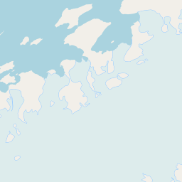
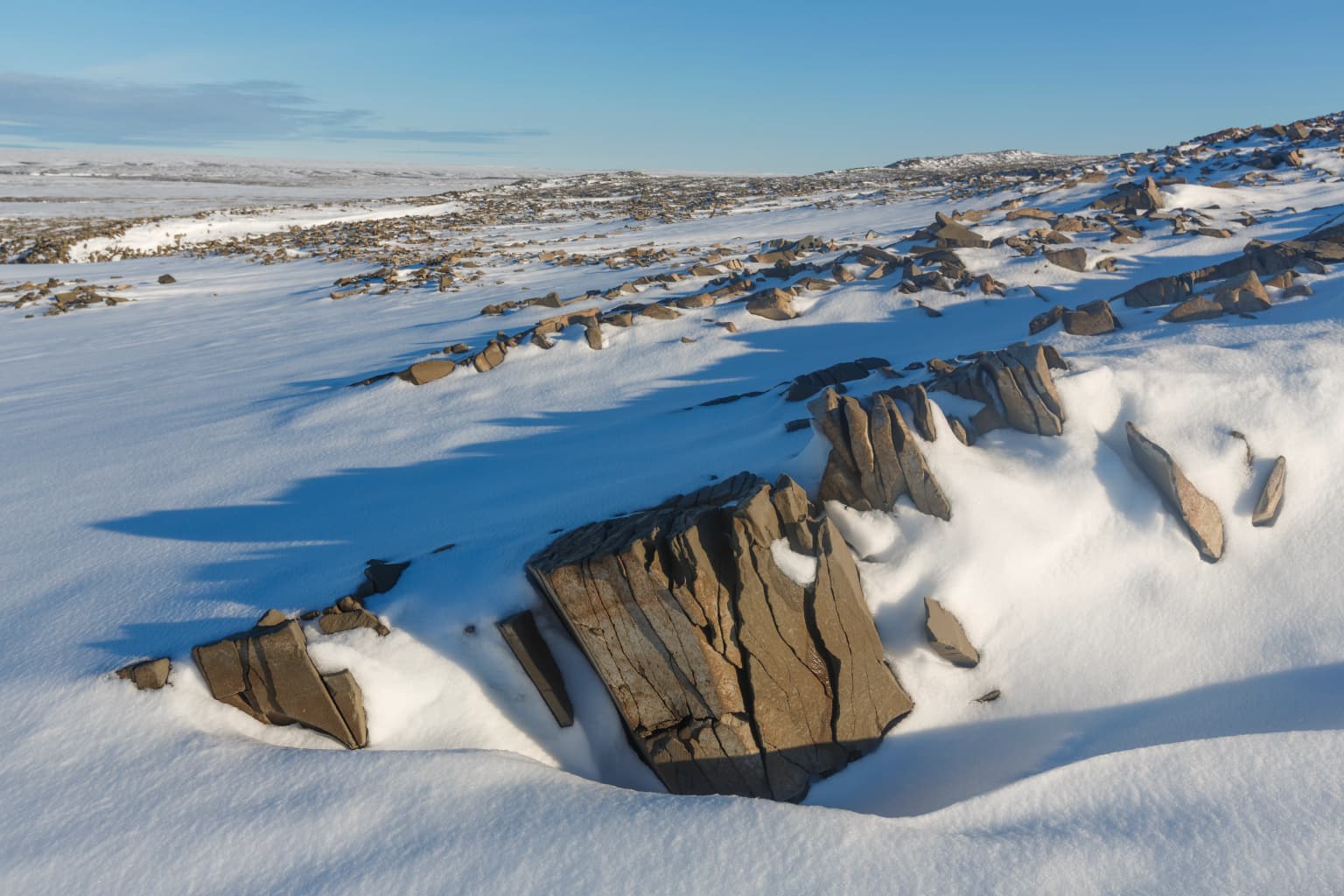
The park protects some of the Arctic's most dramatic and geologically diverse terrain. Franz Josef Land consists of nearly 200 islands featuring a mix of volcanic bedrock and extensive glaciation, with ice caps covering much of the terrain and glaciers descending directly into the sea. The islands feature steep coastal cliffs reaching heights of several hundred meters, providing ideal nesting habitat for seabird colonies. Novaya Zemlya's northern Severny Island encompasses mountain ranges exceeding 1,500 meters, with glaciers and permanent snow fields dominating the high terrain. The coastline features numerous fjords, headlands, and restricted bays where pack ice persists well into the summer months. The marine environment includes both open Arctic Ocean waters and portions of the Barents Sea and Kara Sea, with the complex interplay of currents creating productive feeding areas for marine mammals. The stark, treeless landscapes are characterized by Arctic tundra vegetation limited to mosses, lichens, and low-growing vascular plants that manage to survive in this harsh environment.

Russian Arctic National Park ecosystems, habitats, and plant life

The Arctic ecosystems within Russian Arctic National Park represent some of the most productive and biologically significant in the circumpolar Arctic. The marine environment supports exceptional concentrations of marine mammals that depend on the seasonal ice and productive waters for their survival. The park's waters serve as critical habitat for bowhead whales, a species of conservation concern that feeds on krill and small crustaceans in these Arctic seas. Gray whales also frequent the area, making the park's ecological value extraordinary among Russian protected areas. Polar bears den on the pack ice and coastal islands, with the population relying on these protected waters for seal hunting. The coastal islands support important walrus and seal rookeries where thousands of marine mammals gather during the breeding season. The terrestrial and coastal environments support one of the largest seabird colonies in the Northern Hemisphere, with millions of birds nesting on the dramatic cliff faces that line the islands' shores.

Russian Arctic National Park wildlife and species highlights

The wildlife of Russian Arctic National Park is characterized by exceptional populations of Arctic marine mammals that represent the park's most significant conservation value. Polar bears are perhaps the most iconic species, with the park providing critical habitat for denning and foraging in the pack ice environment surrounding the islands. Bowhead whales congregate in the productive waters of the Barents Sea and Kara Sea, feeding on the abundant krill and zooplankton that thrive in these cold, nutrient-rich environments. Gray whales also pass through the park's waters during their seasonal migrations. Walrus colonies form massive haul-outs on the islands' beaches, particularly on the flat coastal areas suitable for breeding and resting. Several seal species, including ringed seals and bearded seals, are resident in the area and rely on the stable ice conditions for pupping. The seabird colonies are extraordinary in scale, with cliff faces supporting enormous concentrations of common guillemots, Brünnich's guillemots, kittiwakes, and other species that nest in dense colonies on the sheer rock faces.

Russian Arctic National Park conservation status and protection priorities

Russian Arctic National Park represents Russia's most significant contribution to Arctic conservation and serves as a flagship for polar ecosystem protection in the nation. The park's establishment recognized that these remote Arctic waters and islands contain irreplaceable ecological values that warrant the highest level of protection. The presence of both bowhead and gray whales, species of global conservation concern, elevates the park's significance beyond national boundaries to international conservation importance. The marine mammal protection afforded by the park positions it among Russia's most important protected areas for these species. The 2016 expansion dramatically increased the marine component of the protected area, recognizing that effective conservation in the Arctic must encompass the waters upon which marine species depend. The ongoing remediation of Soviet-era contamination demonstrates the commitment to restoring the environmental integrity of these globally significant Arctic ecosystems.

Russian Arctic National Park cultural meaning and human context

The remote islands of Russian Arctic National Park contain evidence of human activity spanning centuries of Arctic exploration and presence. The archipelagos were among the last major land regions on Earth to be discovered and mapped by Europeans, with exploration beginning in the 16th century as navigators sought new routes between the Atlantic and Pacific Oceans. Franz Josef Land was first discovered in 1873 by the Austro-Hungarian expedition of Karl Weyprecht and Julius von Payer, and the islands bear names reflecting that expedition's patronage. The history of 20th-century Soviet presence is evident in the abandoned installations, military infrastructure, and waste that the environmental cleanup project has addressed. These remnants, while presenting environmental challenges, also represent an important historical record of human adaptation to extreme Arctic conditions and the strategic importance of these remote territories during the Cold War era.

Top sights and standout views in Russian Arctic National Park

Russian Arctic National Park protects the most northerly terrestrial and marine environments in Russia, encompassing dramatic Arctic archipelagos that remain among the most remote and least-visited wilderness areas in the Northern Hemisphere. The park supports the highest concentrations of polar bears in the Russian Arctic and provides critical habitat for bowhead and gray whales, species of global conservation significance. The vast seabird colonies represent one of the most spectacular wildlife phenomena in the Arctic, with millions of birds nesting on towering cliff faces. The 2016 expansion created one of the world's largest marine protected areas, recognizing that true Arctic conservation must extend far beyond shoreline protection to encompass the productive waters that sustain the entire ecosystem.

Best time to visit Russian Arctic National Park

Visiting Russian Arctic National Park is possible during the brief Arctic summer from approximately June through August, when temperatures rise above freezing and the midnight sun illuminates the landscape continuously. This is the optimal season for wildlife viewing, as walrus haul-outs are accessible and polar bears can be observed on the pack ice. The summer months also offer the best conditions for boat-based exploration through the fjords and around the islands. The polar night from November through February creates extreme darkness and cold that precludes most visitation, though this period offers opportunities for observing the aurora borealis for those willing to endure the harsh conditions. Spring and autumn transitional periods feature variable conditions with emerging and retreating ice respectively, creating potentially dangerous conditions for navigation.

Park location guide

Geography guide, regional context, and park location map for Russian Arctic National Park

Russian Arctic National Park park geography, regions, and map view in Russia
Understand where Russian Arctic National Park sits in Russia through a broader geographic reading of the surrounding landscape, nearby location context, and its mapped position within the national park landscape.

How Russian Arctic National Park fits into Russia

Russia is a transcontinental nation spanning eleven time zones, bordered by fourteen countries. It is the world's largest country by area, covering 17,098,246 km². Moscow is the capital and largest city, while Saint Petersburg is the second-largest and a major cultural centre.

Wider geography shaping Russian Arctic National Park in Russia

Russia spans Eastern Europe and North Asia, covering 17,098,246 km². It shares land borders with fourteen countries, more than any other nation, and spans eleven time zones. The landscape includes vast plains, mountain ranges such as the Urals and Caucasus, and extensive coastlines along the Arctic Ocean, Pacific Ocean, Baltic Sea, Black Sea, and Caspian Sea.

Map view of Russian Arctic National Park

Use this park location map to pinpoint Russian Arctic National Park in Russia, understand its exact geographic position, and read its mapped placement within the surrounding landscape more clearly.

Pigeon | © OpenStreetMap contributors

Location context for Russian Arctic National Park

Arkhangelsk OblastNovaya Zemlya

Discover compelling imagery showcasing the dramatic glacial terrain, vast marine environments, and unique wildlife of this remote Arctic protected area.

Visual Exploration: Russian Arctic National Park Landscapes, Scenery, and Protected Habitats
Explore a curated collection of photographs to visually comprehend the expansive, ice-covered terrain and critical wildlife habitats found within Russian Arctic National Park. These detailed images provide essential context for understanding the park's rugged coastal cliffs, pristine marine ecosystems, and the environment sustaining polar bears and immense seabird colonies.

Snow-covered terrain with exposed rocky outcrops under a clear blue sky

Tall wooden tower structure on a rocky coastal plain with the sea in the background under an overcast sky

Park atlas

Map adjacent protected areas, comparing Arctic wilderness, unique marine environments, and northernmost territories.

Explore Related Arctic Protected Areas and National Parks Near Russian Arctic National Park
Browse other national parks and protected areas near Russian Arctic National Park, tracing the broader pattern of conservation across the Arctic and adjacent northern territories. Compare these sites to gain a deeper understanding of geographic spread, diverse Arctic ecosystems, and the varying protected status of northern wilderness landscapes.
National parkSvalbard

Sassen, Bünsow Land National Park: A Mapped Arctic Glacial Landscape in Svalbard

Explore protected boundaries and polar terrain.

Sassen, Bünsow Land National Park, located in the heart of Spitsbergen, Norway, showcases a quintessential Arctic wilderness defined by its expansive glacial features and deeply incised valleys. This protected area, part of the Svalbard archipelago, offers rich geographic context through its mapped terrain, highlighting glacial processes that have shaped the landscape. Discover the unique polar environment and the significance of this national park within the broader Norwegian Arctic atlas.

Area
1,230 km²
Established
2003
IUCN
II
Relief
Mountain
National park

Indre Wijdefjorden National Park: Arctic Steppe and Fjord Protected Landscape Exploration

Mapped protected boundaries and unique terrain in Svalbard.

Discover the unique High Arctic steppe and dramatic fjord landscape of Indre Wijdefjorden National Park, a protected area in Svalbard, Norway. This park safeguards a rare ecosystem with endemic plant species, offering exceptional insights into Arctic geography and protected land conservation. Explore its mapped boundaries and distinct terrain, a key destination for atlas-based landscape discovery.

Area
1,127 km²
Established
2005
IUCN
II
Relief
Mountain
National park

Sør-Spitsbergen National Park: Mapping Norway's Pristine Arctic Protected Landscape

Explore glacial terrain, tundra ecosystems, and significant seabird colonies.

Delve into Sør-Spitsbergen National Park, a cornerstone of Arctic protected areas within Norway's Svalbard archipelago. This extensive national park showcases raw glacial terrain, expansive ice caps, and sparse tundra valleys, offering a unique geographic context. It is globally recognized for its vast seabird colonies, particularly the dense nesting sites of thick-billed guillemots, and Ramsar-protected wetlands. Understanding Sør-Spitsbergen National Park through its mapped boundaries and landscape features provides critical insight into Arctic conservation and natural processes.

Area
8,504 km²
Established
1973
IUCN
II
Relief
Mixed relief
National parkFinnmark

Varangerhalvøya National Park: Explore Finnmark's Unique Subarctic Protected Landscape

Mapped tundra, wetlands, and Arctic fox conservation.

Varangerhalvøya National Park offers a compelling atlas exploration of Norway's northeasternmost protected landscapes. This national park in Finnmark is distinguished by its subarctic terrain, featuring expansive tundra, diverse wetlands, and a unique ecological position where multiple biomes converge. It is a critical habitat for the Arctic fox and a vital Important Bird Area, providing deep insights into protected area geography and landscape context for those studying regional conservation and natural formations.

Area
1,804.1 km²
Established
2006
IUCN
II
Relief
Lowland
Watercolor illustration of a fjord with mountains, trees, and water bodies
National parkSpitsbergen

Nordre Isfjorden National Park: Arctic Coastal Protected Landscape

Discover Spitsbergen's mapped fjord geography and wildlife.

Nordre Isfjorden National Park on Spitsbergen offers a compelling view into a pristine Arctic environment. This protected national park encompasses dramatic coastal cliffs, tundra terrain, and the biologically rich waters of Isfjorden. It is renowned for supporting immense seabird colonies that rely on the nutrient-dense fjord, making it a significant site for understanding high Arctic ecosystems and marine protected areas.

Area
2,954 km²
Established
2003
IUCN
II
Relief
Lowland
National parkSvalbard

Nordvest-Spitsbergen National Park: Protected Arctic Landscape and Geographic Atlas

Explore unique hot springs, glacial terrain, and polar expedition history.

Nordvest-Spitsbergen National Park, a protected national park in Norway's Svalbard archipelago, showcases dramatic Arctic geography. This page details its mapped landscapes, from volcanic terrains and glacial valleys to its famed northernmost hot springs. Discover the park's protected area status, its role in regional geography, and its historical significance for polar exploration, providing a rich context for atlas-based exploration.

Area
9,914 km²
Established
1973
IUCN
II
Relief
Mixed relief
National parkSvalbard

Forlandet National Park: High Arctic Protected Landscape and Global Wildlife Limits

Explore mapped geography and protected ecosystem boundaries in Svalbard.

Forlandet National Park stands as a crucial element in the Arctic atlas, safeguarding the island of Prins Karls Forland and its surrounding marine territories. As the world's most northerly national park, it showcases a unique High Arctic landscape defined by stark coastal cliffs and vital waters supporting specialized wildlife. This protected area is recognized for harboring the most extreme northern populations of seals and common guillemots, making it a significant site for understanding polar ecosystems and conservation efforts within the Svalbard region.

Area
4,647 km²
Established
1973
IUCN
II
Relief
Lowland
National park

Øvre Pasvik National Park: Norway's Pristine Siberian Taiga & Mapped Boreal Geography

Explore ancient forests, wetlands, and transboundary protected landscapes.

Øvre Pasvik National Park is a landmark protected area in Northern Norway, showcasing a remarkably intact Siberian taiga ecosystem characterized by ancient Scots pine forests and extensive wetlands. This national park offers a unique geographic perspective with its notably flat terrain, distinguishing it within the broader Norwegian atlas. As part of the Pasvik, Inari Trilateral Park, it highlights significant transboundary conservation efforts and provides a valuable mapped resource for understanding European boreal landscapes and their unique wildlife habitats.

Area
119 km²
Established
1970
IUCN
II
Relief
Lowland

Common questions about visiting, size, designation, and location context for Russian Arctic National Park

Russian Arctic National Park FAQs for park facts, access, geography, and protected area context
Find quick answers about Russian Arctic National Park, including protected-area facts, park geography, trail and visitor context, and how the park fits into its surrounding country and regional landscape.
MoriAtlas Explorer

Continue Your Protected Areas Search Across the Global Atlas

Deepen your exploration by continuing the structured search for national parks and protected areas worldwide. Utilize the comprehensive filtering capabilities to compare different conservation landscapes and refine your understanding of global park geography. Discover more about the distribution and characteristics of protected natural areas.

Global natural geography