Mori Atlas logo
National parkSagarmatha National Park

Understand the protected landscape and regional geography of Sagarmatha National Park in Koshi Province.

Sagarmatha National Park: A Protected National Park with Defined Geographic Boundaries

Sagarmatha National Park represents a significant protected national park entity within the geographic scope of Koshi Province, Nepal. This page offers a detailed atlas-style exploration of its mapped boundaries and the surrounding natural landscape. Understand its place within regional geography and discover the structured context of this protected area for comprehensive map-based discovery.

Himalayan mountainsUNESCO World Heritage SiteMount EverestAlpine ecosystemsProtected areaNational park

Sagarmatha National Park

National park

Park overview

Structured park overview, official facts, and landscape profile for Sagarmatha National Park

Sagarmatha National Park park facts, protected area profile, and essential visitor context
Review the core facts for Sagarmatha National Park, including designation, size, terrain, visitor scale, habitats, and operating context in one park-focused overview.

About Sagarmatha National Park

Sagarmatha National Park occupies a position of unique global significance as both a natural treasure and a cultural landscape of extraordinary importance. The park's establishment in 1976 marked a pivotal moment in Nepal's conservation history, and its inscription as a World Heritage Site in 1979 solidified its international recognition as a place of outstanding universal value. The park encompasses the upper reaches of two major river systems and the spectacular Gokyo Lakes, creating a hydrological network that sustains both wildlife and human communities throughout the broader watershed. The dramatic topographical relief, with elevation differences exceeding 6,000 meters within the park boundaries, creates an extraordinary diversity of habitats from subalpine forests through alpine meadows to permanent snow and ice. This vertical zonation supports remarkable biodiversity despite the harsh conditions, with over 1,000 floral species and 208 bird species documented within the park's boundaries. The park's buffer zone, added in 2002 and covering 275 square kilometers, extends protection to surrounding communities and creates a transition between core protected areas and human-influenced landscapes. The management framework balances conservation priorities with the needs of local Sherpa communities, whose traditional land use practices and cultural heritage are integral to the park's identity.

Quick facts and research context for Sagarmatha National Park

Located in Koshi Province, eastern Nepal, Sagarmatha National Park protects the upper catchment areas of the Dudh Kosi and Bhotekoshi rivers along with the sacred Gokyo Lakes. The park's elevation span from 2,845 to 8,848 meters creates distinct climatic zones: temperate and subalpine forests above 3,000 meters, alpine tundra above 4,000 meters, and permanent nival zone above 5,000 meters. Barren rock and ice dominate 69% of the park's area, while grazing land accounts for 28% and forests only 3%. Major peaks including Everest, Lhotse, Cho Oyu, Thamserku, Nuptse, Amadablam, and Pumori rise above 6,000 meters, creating one of the most dramatic mountain landscapes on Earth.

Park context

Deeper park guide and search-rich context for Sagarmatha National Park

Sagarmatha National Park history, landscape, wildlife, and travel context
Explore Sagarmatha National Park through its history, landscape character, ecosystems, wildlife, conservation priorities, cultural context, and seasonal travel timing in a structured park guide built for atlas discovery and search intent.

Why Sagarmatha National Park stands out

Sagarmatha National Park is best known as the protected realm of Mount Everest, the world's highest peak, and as Nepal's first natural World Heritage Site. The park is renowned for its extraordinary alpine landscapes, where towering Himalayan peaks rise above glaciers, deep river valleys, and sacred alpine lakes. It is equally distinguished for its unique ecological zones that support specialized flora and fauna adapted to extreme altitudes, including rare species like the snow leopard and the endangered Himalayan tahr. The park's cultural significance is equally profound, as it has been home to Sherpa communities for centuries who maintain deep spiritual connections to this sacred mountain environment.

Sagarmatha National Park history and protected-area timeline

Sagarmatha National Park was established on July 19, 1976, becoming one of Nepal's earliest protected areas. The park's creation reflected growing recognition of the need to conserve the unique Himalayan environment surrounding the world's highest mountain. In 1979, just three years after its establishment, Sagarmatha achieved the distinction of becoming Nepal's first national park to be inscribed as a Natural World Heritage Site by UNESCO, a remarkable achievement that recognized the park's exceptional natural value on the global stage. January 2002 marked another significant milestone when a Buffer Zone of 275 square kilometers was added to the park, expanding the protected landscape and integrating surrounding communities into conservation management. Tourism in the Sagarmatha region began in the early 1960s, coinciding with the emergence of commercial mountaineering in the Himalayas. By 2003, approximately 19,000 tourists annually visited the park, drawn by the opportunity to experience the iconic Himalayan landscape and trek through villages where Sherpa communities have lived for generations.

Sagarmatha National Park landscape and geographic character

The landscape of Sagarmatha National Park is defined by its extraordinary vertical relief and the powerful geological forces that continue to shape this high-altitude environment. The park spans from the Dudh Kosi river valley at its lower reaches through a progression of increasingly austere terrain to the summit of Mount Everest and the perpetual snow line that begins above 5,000 meters. The upper catchment areas of the Dudh Kosi and Bhotekoshi rivers drain meltwater from glaciers that descend from the highest peaks, feeding downstream communities across the Himalayan foothills. The Gokyo Lakes, a sacred sequence of alpine glacial lakes, form one of the park's most distinctive features, set against a backdrop of sheer granite walls and hanging glaciers. Above 5,000 meters, barren rock and permanent snow dominate 69% of the park's terrain, while the remaining area consists primarily of alpine meadows used for seasonal grazing. Major peaks including Lhotse, Cho Oyu, Thamserku, Nuptse, Amadablam, and Pumori create a ring of towering summits that enclose the protected area, their steep faces and dramatic ridgelines representing some of the most spectacular mountain scenery anywhere on Earth.

Sagarmatha National Park ecosystems, habitats, and plant life

The ecological character of Sagarmatha National Park reflects the extreme environmental conditions that shape life at high altitude in the Himalayas. The park's vegetation follows a distinct altitudinal zonation, with subalpine forests of fir, Himalayan birch, and rhododendron covering the lower slopes below 4,000 meters. Above this zone, juniper and rhododendron dominate the transition to alpine terrain, while mosses and lichens represent the limit of plant life above 5,000 meters where harsh conditions permit only the most resilient organisms to survive. The dramatic elevation range from 2,845 to 8,848 meters creates multiple climatic zones: temperate and subalpine conditions above 3,000 meters, true alpine environment above 4,000 meters where vegetation reaches its upper limits, and the nival zone of permanent snow and ice beginning at 5,000 meters. This vertical gradient supports remarkable biodiversity despite the challenging conditions, with more than 1,000 floral species recorded within the park. The specialized plant communities have evolved remarkable adaptations to survive extreme temperatures, intense ultraviolet radiation, and seasonal drought, making this an outstanding example of high-altitude ecosystem resilience.

Sagarmatha National Park wildlife and species highlights

Sagarmatha National Park supports a remarkable community of wildlife species adapted to the challenging high-altitude environment, with 208 bird species documented within its boundaries. The park has been designated as an Important Bird Area, recognizing its significance for bird conservation. Notable avian species include the Impeyan pheasant, Nepal's national bird, the bearded vulture with its distinctive beard-like plumage, various snowcock species, and the alpine chough that thrives in the highest regions. Among mammals, the park provides habitat for several endangered and threatened species. The snow leopard inhabits elevations above 3,500 meters, moving silently across the rocky terrain in search of prey, while the Indian leopard roams the forested areas at lower elevations. Ungulate species include the Himalayan tahr, a large wild goat with a distinctive shaggy coat, the Himalayan serow, and the secretive musk deer whose valuable musk has historically made it a target of poaching. These species have adapted to the harsh conditions, with many exhibiting thick fur and physiological adaptations for survival in the cold, thin air of these extreme elevations.

Sagarmatha National Park conservation status and protection priorities

Sagarmatha National Park represents one of the most significant conservation achievements in South Asia, protected both by national legislation and international recognition as a UNESCO World Heritage Site. The park's World Heritage status, inscribed in 1979 under criterion vii for outstanding natural beauty and spectacle, reflects the global consensus that this landscape represents irreplaceable natural value that must be preserved for future generations. The 2002 establishment of a 275 square kilometer buffer zone extended conservation frameworks to encompass surrounding communities and their interactions with the broader landscape. Under the Buffer Zone Management Guidelines, conservation of forests, wildlife, and cultural resources receives priority, with additional attention to developing alternative energy sources to reduce pressure on local forests. The park's inclusion in the Sacred Himalayan Landscape initiative links it to a broader regional conservation framework that recognizes the interconnectedness of protected areas across the Nepalese and Himalayan landscape. Conservation challenges include managing the impact of increasing tourism, protecting vulnerable species like the snow leopard from poaching, and addressing the effects of climate change on glacial systems and alpine ecosystems.

Sagarmatha National Park cultural meaning and human context

Sagarmatha National Park is deeply intertwined with the cultural heritage of the Sherpa people, an ethnic group with origins in Tibet who have inhabited the Khumbu region for centuries. Approximately 3,500 Sherpa people live in villages and seasonal settlements situated along the main tourist trails, maintaining traditional lifestyles that are closely connected to the high-altitude environment. The Sherpa community's relationship with the landscape extends beyond practical livelihood considerations to encompass deep spiritual beliefs, with the mountains, rivers, and forests considered sacred and imbued with religious significance. Monasteries such as Tengboche serve as cultural centers where Buddhist traditions are preserved and practiced, and the rhythm of village life follows both agricultural cycles and religious observances. The park's name itself derives from the Nepali word for Mount Everest, reflecting the central place this peak holds in the national consciousness. Tourism has become a significant part of the local economy, with trekking and mountaineering providing income opportunities while also creating cultural exchanges between Sherpa communities and visitors from around the world.

Top sights and standout views in Sagarmatha National Park

Sagarmatha National Park offers an unparalleled combination of natural grandeur, ecological significance, and cultural depth that makes it one of the world's most extraordinary protected areas. The opportunity to trek through a landscape dominated by Mount Everest and other 8,000-meter peaks, through villages where Sherpa traditions have been maintained for generations, creates an experience that transcends ordinary travel. The Gokyo Lakes, with their vivid turquoise waters set against walls of granite and ice, represent one of the most photographed scenes in the Himalayan region. The chance to encounter wildlife including the elusive snow leopard, the majestic Himalayan tahr, and the colorful Impeyan pheasant adds another dimension to the park's appeal. The network of Sherpa monasteries, particularly the famous Tengboche monastery, provides access to living Buddhist tradition in an environment where spiritual practice has been woven into daily life for centuries. The progression through distinct ecological zones from subalpine forest through alpine meadow to nival wilderness offers a compressed education in mountain ecology that is difficult to find elsewhere.

Best time to visit Sagarmatha National Park

The optimal seasons for visiting Sagarmatha National Park correspond to the periods when weather conditions are most stable and visibility is clearest, typically during the pre-monsoon spring months from March to May and the post-monsoon autumn months from October to November. Spring brings warmer temperatures and the bloom of rhododendrons that color the forest slopes in vivid red and pink, though increasing cloudiness from approaching monsoon weather can occur toward May. Autumn offers consistently clear skies after the monsoon departs, with crisp temperatures and excellent visibility for viewing the famous Himalayan peaks, though nighttime temperatures drop significantly at high elevations. The winter months from December to February bring harsh conditions with heavy snow and extremely cold temperatures that make trekking difficult and dangerous, while the monsoon season from June to September brings heavy rainfall, landslides, and reduced visibility that can close trails. Regardless of season, visitors must be prepared for rapidly changing weather conditions and the physiological challenges of operating at extreme altitudes where oxygen availability is significantly reduced.
Park location guide

Geography guide, regional context, and park location map for Sagarmatha National Park

Sagarmatha National Park park geography, regions, and map view in Nepal
Understand where Sagarmatha National Park sits in Nepal through a broader geographic reading of the surrounding landscape, nearby location context, and its mapped position within the national park landscape.

How Sagarmatha National Park fits into Nepal

Nepal is a federal parliamentary republic in South Asia, landlocked between China and India. It spans the Himalayas and includes eight of the world's ten highest mountains. Kathmandu is the capital and largest city.

Wider geography shaping Sagarmatha National Park in Nepal

Nepal is located in South Asia, landlocked between China to the north and India to the south, east, and west. The country occupies the Himalayan region in the north and extends into the Indo-Gangetic Plain in the south. Terrain includes the Terai lowlands, subalpine hills, and the Himalayas with peaks including Mount Everest.

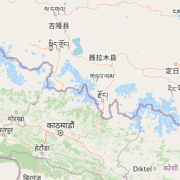
Map view of Sagarmatha National Park

Use this park location map to pinpoint Sagarmatha National Park in Nepal, understand its exact geographic position, and read its mapped placement within the surrounding landscape more clearly.

Pigeon | © OpenStreetMap contributors

Location context for Sagarmatha National Park

Koshi Province
Park atlas

Map the diverse high-alpine ecosystems and protected landscapes across the broader Himalayan region, tracing geographical connections from Nepal.

Discover Other National Parks and Protected Areas Surrounding Sagarmatha National Park
Explore a curated selection of national parks and protected areas located near Sagarmatha National Park, tracing their geographic spread across the challenging high-altitude terrain and extensive river valleys of the Himalayas. Gain a comprehensive understanding of regional conservation efforts and compare diverse alpine ecosystems, revealing the interconnected protected landscapes of this iconic mountain range.
Watercolor illustration of mountain landscape with green slopes and blue peaks, showing a valley with yellow flowers in the foreground
National parkKoshi Province

Makalu Barun National Park: Protected Landscape and Regional Geography in Koshi Province

Explore the mapped boundaries of this national park.

Makalu Barun National Park is a designated national park providing critical protected landscape data for geographic discovery. Understand its position within Koshi Province and its specific mapped boundaries, offering insights into Nepal's protected areas. This entry is designed for users seeking detailed atlas information on the park's terrain and its role in regional conservation contexts.

Area
1,500 km²
Established
1992
IUCN
II
Relief
Mountain
A watercolor painting depicting a river flowing through a valley with mountains in the background and green forests
National parkNepal

Langtang National Park: Nepal's Pioneer Himalayan Protected Landscape and Alpine Atlas

Mapped glaciated terrain, sacred lakes, and towering peaks define this national park.

Langtang National Park, established as Nepal's first Himalayan national park, offers a unique window into high-altitude protected landscapes. Its geography is characterized by dramatic glaciated valleys, soaring mountain peaks including Langtang Lirung, and a rich diversity of alpine ecosystems. This page provides an atlas-centric view of the park's boundaries and its significance within the broader Himalayan conservation context.

Area
1,710 km²
Established
1976
IUCN
II
Relief
Mountain
National parkNepal

Shivapuri Nagarjun National Park: National Park Mapping and Geographic Identity in Nepal

Explore protected boundaries and natural terrain.

Shivapuri Nagarjun National Park serves as a prime example of a protected natural area within Nepal, offering valuable geographic context for atlas exploration. This detail page provides insights into the park's mapped boundaries, its designation as a national park, and its place within the country's diverse natural landscapes. Understanding the terrain and regional distribution of protected areas like Shivapuri Nagarjun National Park is crucial for a comprehensive geographic perspective.

Area
159 km²
Established
2002
IUCN
II
Relief
Mountain
National parkSikkim

Khangchendzonga National Park: National Park in Sikkim with Mapped Boundaries

Explore protected landscapes and regional geography.

Understand Khangchendzonga National Park as a key protected area within Sikkim, India. This entry provides focused atlas information on the park's geographic features, mapped boundaries, and its role as a national park, offering essential context for regional landscape discovery and exploration.

Area
1,784 km²
Established
1977
IUCN
II
Relief
Mountain
National parkDarjeeling District

Singalila National Park: A High-Altitude Protected Landscape on the Eastern Himalayan Ridge

Explore mapped terrain and alpine park geography in Darjeeling District.

Singalila National Park represents a crucial protected natural landscape within the Eastern Himalayas, located in India's Darjeeling District. Defined by its dramatic ridgeline that ascends to over 4,000 meters, the park offers a unique alpine environment with stunning panoramic views. Its designation as a national park highlights its importance for conservation and its role in the regional geographic atlas. Discover the mapped boundaries and ecological context of this remarkable mountain wilderness, from its dense forests to its open alpine meadows.

Area
78.6 km²
Established
1986
IUCN
II
Relief
Mountain
National parkKalimpong district

Neora Valley National Park: India's Protected Landscape in Kalimpong District

Explore mapped boundaries and regional geography.

Neora Valley National Park is a significant protected area designated as a national park in India, located within the Kalimpong district. This dedicated page provides detailed geographic information, focusing on its mapped boundaries and its role as a natural landscape within the region. Understand the specific protected-area context of Neora Valley National Park for atlas-based discovery.

Area
88 km²
Established
1986
IUCN
II
Relief
Mountain
National parkNepal

Chitwan National Park: Nepal's Designated National Park Landscape

Explore mapped boundaries and surrounding regional geography.

Chitwan National Park is a vital protected area offering critical insights into Nepal's natural geography. This entry provides detailed information on the park's specific landscape characteristics and its mapped boundaries, crucial for anyone interested in the atlas-level understanding of protected lands within South Asia. Discover the geographic context of this national park and its significance within the broader conservation framework of Nepal.

Area
952.63 km²
Established
1973
IUCN
II
Relief
Mixed relief
National parkNepal

Parsa National Park: Mapped Protected Landscape Within Nepal's Geography

Explore its national park status and geographic setting.

Parsa National Park represents a significant protected area within the geographic framework of Nepal. This page provides critical atlas context, detailing the park's mapped boundaries and its role as a national park. It serves as an essential resource for understanding the specific landscape features and regional geographic positioning of Parsa National Park, contributing to a structured view of protected lands across South Asia.

Area
627.39 km²
Established
2017
IUCN
II
Relief
Lowland

Common questions about visiting, size, designation, and location context for Sagarmatha National Park

Sagarmatha National Park FAQs for park facts, access, geography, and protected area context
Find quick answers about Sagarmatha National Park, including protected-area facts, park geography, trail and visitor context, and how the park fits into its surrounding country and regional landscape.
MoriAtlas Explorer

Continue Your Protected Areas Search Across the Global Atlas

Deepen your exploration by continuing the structured search for national parks and protected areas worldwide. Utilize the comprehensive filtering capabilities to compare different conservation landscapes and refine your understanding of global park geography. Discover more about the distribution and characteristics of protected natural areas.

Global natural geography