

Mori Atlas logo
National parkSalt Range National Park

Discover the mapped geography and protected area context of this Pakistani natural landscape.

Salt Range National Park: A Protected National Park Landscape in Pakistan

Salt Range National Park stands as a designated national park within Pakistan, offering a distinct protected landscape for geographic exploration. This page serves as your atlas entry point to understand its place within Pakistan's diverse terrain and national conservation efforts. Delve into the mapped context of this protected area, uncovering its unique geographic features and contribution to the regional natural landscape.

geological parksalt formationssemi-arid landscapePunjab regionprotected areaPakistan

Salt Range National Park

National park

Park overview

Structured park overview, official facts, and landscape profile for Salt Range National Park

Salt Range National Park park facts, protected area profile, and essential visitor context

Review the core facts for Salt Range National Park, including designation, size, terrain, visitor scale, habitats, and operating context in one park-focused overview.

About Salt Range National Park

Salt Range National Park protects a segment of the broader Salt Range geological province in Pakistan. This region represents a unique geological landscape within the country\'s topography, characterized by its formation of salt domes, gypsum layers, and calcareous deposits that create a distinctive visual and geological character. The protected area aims to preserve both the geological features and the natural ecosystems that exist within this semi-arid mountain environment. The Salt Range extends across portions of the Potohar plateau and Jhelum, Chakwal, and Khushab districts, creating a landscape that contrasts with the surrounding plains of central Punjab. The geological significance of the area, combined with its historical and cultural importance, makes it a notable protected area within Pakistan\'s system of national parks and wildlife sanctuaries.

Quick facts and research context for Salt Range National Park

Salt Range National Park is situated in the Salt Range region of Punjab, Pakistan, a mountainous area known for its salt deposits and geological significance. The protected area encompasses portions of the distinctive salt dome topography that defines this region. The park represents Pakistan\'s effort to protect geological heritage alongside natural landscapes. The broader Salt Range area is recognized for its archaeological significance and unique semi-arid ecosystem characteristics.

Protection and recognition

Verifying terrestrial boundaries and official reserve classifications within the regional atlas.

Salt Range National Park Protection Status and Conservation Designations

Users can explore the formal protection framework of Salt Range National Park, highlighting its established terrestrial scope and official classification within the regional geographic database. Understanding these documented designation details helps researchers trace how the surrounding landscape fits into global conservation networks.

Protection details

Protection scope
Terrestrial
Park context

Deeper park guide and search-rich context for Salt Range National Park

Salt Range National Park history, landscape, wildlife, and travel context

Explore Salt Range National Park through its history, landscape character, ecosystems, wildlife, conservation priorities, cultural context, and seasonal travel timing in a structured park guide built for atlas discovery and search intent.

Why Salt Range National Park stands out

The park is primarily known for its geological setting within the Salt Range, one of Pakistan\'s most distinctive geological formations. The region contains significant salt deposits that have been extracted for centuries, and the landscape features characteristic domed salt formations, gypsum ridges, and fossil-rich sedimentary rocks. The area is also noted for its archaeological significance, with ancient Buddhist sites and historical mining operations in the surrounding region.

Salt Range National Park history and protected-area timeline

The establishment of Salt Range National Park reflects Pakistan\'s broader efforts to develop a comprehensive system of protected areas that encompass geological as well as biological diversity. The Salt Range has been an area of human activity for millennia, with evidence of ancient settlement, Buddhist monastic communities, and traditional salt mining operations. The formal designation of portions of this region as a national park represents relatively recent conservation efforts aimed at preserving both the natural landscape and the cultural heritage embedded in this geological province.

Salt Range National Park landscape and geographic character

The landscape of Salt Range National Park is defined by its characteristic salt domes and geological formations that rise prominently from the surrounding terrain. The topography features rolling hills, exposed rock formations, and the distinctive white and gray hues of salt and gypsum deposits. The semi-arid environment supports sparse vegetation adapted to the harsh conditions, with drought-resistant shrubs and grasses dominating the ground cover. The geological formations create a landscape of visual distinction, with the salt domes and mineral-rich strata offering evidence of the region\'s ancient geological history.

Salt Range National Park ecosystems, habitats, and plant life

The ecological character of the Salt Range area reflects its semi-arid setting and geological substrate. Vegetation in the region consists primarily of xeric (drought-adapted) plant communities adapted to limited rainfall and mineral-rich soils. The park\'s location within a geological formation rather than a typical ecological zone means that biodiversity documentation remains limited compared to more extensively studied protected areas in Pakistan. The area supports specialized plant species adapted to the unique soil conditions created by the salt and gypsum deposits.

Salt Range National Park wildlife and species highlights

Wildlife presence in the Salt Range area reflects the semi-arid and somewhat harsh environmental conditions of this geological landscape. Available documentation indicates that the area supports populations of adapted species including various rodents, reptiles, and bird species that have specialized to survive in the dry, mineral-rich environment. Specific detailed wildlife inventories for the national park boundaries are not extensively documented in available sources.

Salt Range National Park conservation status and protection priorities

Salt Range National Park represents a conservation designation aimed at protecting geological heritage alongside natural landscapes in a region that has historically been subject to mining and resource extraction. The protected area status reflects an awareness of the need to preserve both the geological formations and the natural ecosystems that exist within this distinctive landscape. The broader Salt Range region faces pressures from mining activities, and protected area status provides a framework for balancing resource use with conservation values.

Salt Range National Park cultural meaning and human context

The Salt Range holds significant cultural and historical importance beyond its geological significance. The region has been inhabited for thousands of years, with archaeological evidence of ancient Buddhist communities, historic temples, and traditional mining settlements. The salt deposits of the range have been exploited since antiquity, making this one of the world\'s oldest continuously mined salt sources. The cultural landscape includes remnants of various historical periods, from ancient Buddhist monasteries to more recent colonial-era mining infrastructure.

Top sights and standout views in Salt Range National Park

The most distinctive aspect of Salt Range National Park is its unique geological character, defined by salt dome formations and mineral deposits that create a landscape unlike any other in Pakistan. The park offers opportunities to observe geological processes and formations in a relatively accessible setting. The broader region contains archaeological sites and historical mining heritage that add cultural dimension to visits. The semi-arid landscape creates a distinctive visual environment with rolling hills and exposed geological strata.

Best time to visit Salt Range National Park

The optimal time to visit Salt Range National Park would be during the cooler winter months from November through March, when temperatures are more comfortable for outdoor exploration. Summers in this region can be extremely hot, making outdoor activities challenging. The winter period also offers clearer visibility for observing the geological formations and landscape. The semi-arid conditions mean that rainfall is limited throughout the year, reducing seasonal variation in accessibility.
Monthly climate preview

Long term average temperature and monthly precipitation patterns for Salt Range National Park

Salt Range National Park Climate Normals and Annual Temperature Rhythm

Representative coordinate records show measured monthly temperature and precipitation baselines spanning twelve distinct intervals across Salt Range National Park. Examining the complete monthly climate normals reveals full seasonal shifts and detailed temperature variations in greater depth.
Annual mean24 °C
11 °C36 °C
Jan11°
Feb14°
Mar20°
Apr26°
May32°
Jun36°
Jul34°
Aug32°
Sep30°
Oct25°
Nov19°
Dec14°
Warmest month
June

35.6 °C

Coolest month
January

11.2 °C

Wettest month
July

3.8 mm/day

Driest month
November

0.3 mm/day

Park location guide

Geography guide, regional context, and park location map for Salt Range National Park

Salt Range National Park park geography, regions, and map view in Pakistan

Understand where Salt Range National Park sits in Pakistan through a broader geographic reading of the surrounding landscape, nearby location context, and its mapped position within the national park landscape.

How Salt Range National Park fits into Pakistan

Pakistan, officially the Islamic Republic of Pakistan, is a federal parliamentary Islamic republic in South Asia. It is the fifth-most populous country and the 33rd-largest by area. The country gained independence from British India in 1947 and has a diverse history spanning ancient civilizations including Mehrgarh and the Indus Valley Civilisation. Pakistan shares maritime borders with Oman and is bounded by the Arabian Sea, Gulf of Oman, and several neighboring countries.

Wider geography shaping Salt Range National Park in Pakistan

Pakistan is located in South Asia, bordered by the Arabian Sea to the south, the Gulf of Oman to the southwest, and shares land borders with India to the east, Afghanistan to the west, Iran to the southwest, and China to the northeast. The country also shares a maritime border with Oman in the Gulf of Oman. The Wakhan Corridor in Afghanistan separates Pakistan from Tajikistan in the northwest.

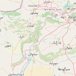
Map view of Salt Range National Park

Use this park location map to pinpoint Salt Range National Park in Pakistan, understand its exact geographic position, and read its mapped placement within the surrounding landscape more clearly.

Pigeon | © OpenStreetMap contributors
Park atlas

Explore the Diverse Protected Landscapes and Geological Formations Surrounding Salt Range National Park

Discover Nearby National Parks and Protected Areas Beyond Salt Range National Park

After exploring Salt Range National Park's unique geological setting, browse other national parks and protected areas across Pakistan's diverse landscape. Compare nearby conservation efforts and trace connected protected landscapes to deepen your understanding of the region's natural and geological heritage.
National parkJhelum District
About 35 km away#1 closest

East

Tilla Reserve National Park: Mapped Protected Landscape and Dry Forest Ecosystem

Explore the geography and ancient heritage of this Salt Range national park.

Tilla Reserve National Park is a protected area recognized for its significant dry subtropical forest ecosystems and rich cultural history within Pakistan's Salt Range. Situated in Jhelum District, the park's landscape is characterized by steep, rocky ridges and ancient geological formations. Discover its unique mapped terrain, the distribution of its remnant forest habitats, and its importance as a protected natural and spiritual site.

Area
40.6 km²
Established
2021
IUCN
II
Relief
Mountain
Wildlife reservePunjab
About 43 km away#2 closest

West

Chumbi Surla Wildlife Sanctuary: Geographic Overview of Punjab Foothill Habitats

Mapping protected scrub forests and ridges in Khushab and Chakwal

Covering thousands of acres of contiguous reserve forest, Chumbi Surla Wildlife Sanctuary represents a crucial protected ecosystem within the Punjab landscape. This high-altitude scrub environment provides an essential refuge for the Punjab urial, characterized by deep valleys, stony slopes, and ridge systems that define the topography of the local Salt Range outliers.

Area
226.4 km²
Established
1978
IUCN
IV
Relief
Upland
National parkPunjab
About 47 km away#3 closest

Northwest

Chinji National Park: National Park Atlas, Salt Range Geography, and Protected Landscape

Discover the unique eroded terrain and semi-arid ecosystems of Punjab, Pakistan.

Chinji National Park is a protected national park located in the Punjab province of Pakistan, specifically within the historic Salt Range. This park is characterized by its deeply eroded terrain, composed of sandstone and igneous rock formations, shaped by seasonal streams that lead towards the Soan River. As a key example of a semi-arid mountain ecosystem within the Baluchistan xeric woodlands ecoregion, Chinji National Park offers significant insights into the geological heritage and unique biodiversity of central Pakistan.

Area
60.95 km²
Established
1987
IUCN
II
Relief
Upland
Protected areaKhushab District
About 75 km away#4 closest

West

Uchhali Complex Protected Area: Geography, Salt Range Lakes, and Wetland Mapping

Key protected wetland landscape in the Soon Valley of Punjab

The Uchhali Complex serves as a critical wetland system characterized by the brackish and saline waters of Khabikki, Uchhali, and Jahlar lakes. Situated in the Soon Valley, this protected area offers a unique geographic perspective on the interplay between the mineralized geology of the Salt Range and the surrounding semi-arid terrain. This detail overview examines the site as a landmark habitat for migratory waterbirds and a defining feature of the Khushab District landscape.

Area
12.43 km²
Established
1996
Access
Access unknown
Scope
Terrestrial
National parkPunjab
About 88 km away#5 closest

North

Kheri Murat National Park: Protected Scrub Forest and Wildlife Conservation in Punjab

Explore the mapped terrain and protected landscape context.

Discover Kheri Murat National Park, a recent national park designation located in Punjab, Pakistan, situated on the rolling hills of the Kala Chitta Range. This protected area features a distinct subtropical thorn scrub forest ecosystem, providing essential habitat for wildlife, including the Punjab urial, and serving as a critical site for bird conservation. Its unique landscape offers valuable insights into regional geography and the preservation of natural wilderness within a predominantly agricultural province, making it a noteworthy entity for atlas exploration.

Area
35.37 km²
Established
2020
IUCN
II
Relief
Mountain
National parkPunjab
About 102 km away#6 closest

East

Pabbi and Rasul Reserve Forest National Park: Punjab's Protected Landscape and Regional Geography

Subtropical thorn scrub, undulating hills, and wetland habitats.

Pabbi and Rasul Reserve Forest National Park, situated in Punjab, Pakistan, is a significant protected area renowned for its subtropical thorn scrub vegetation and its role in conserving the Pothohar Plateau's biodiversity. The park's landscape features a diverse mosaic of undulating hills, scrub-covered ridges, grasslands, and wetlands, situated within the dry tropical environments characteristic of northern Punjab. Its recent designation as a national park highlights its importance for regional conservation efforts, offering a unique glimpse into the mapped geography and protected natural landscapes of the region.

Area
147.2 km²
Established
2023
IUCN
II
Relief
Upland
National parkIslamabad Capital Territory
About 116 km away#7 closest

North

Margalla Hills National Park: Pakistan's Gateway to Himalayan Foothills Geography

Mapped protected landscape with rich Sino-Himalayan biodiversity.

Margalla Hills National Park, situated in the Islamabad Capital Territory, serves as Pakistan's most accessible national park and a vital entry point to the Himalayan foothills. This protected landscape is defined by its rugged mountain terrain, ranging from lower scrublands to higher pine and oak woodlands, with elevations up to 1,604 meters. The park's geological significance, with ancient marine fossil formations, adds a unique dimension to its natural identity. Discover the mapped boundaries and ecological richness that characterize this important protected area, offering insights into regional geography and diverse habitats.

Area
173.86 km²
Established
1980
IUCN
V
Relief
Mountain
National parkAttock District
About 119 km away#8 closest

Northwest

Kala Chitta National Park: Protected Dry Temperate Forest in Attock District, Pakistan

Discover unique hill landscapes and a rare ecosystem on the Pothohar Plateau.

Kala Chitta National Park represents a crucial protected area in Punjab, Pakistan, safeguarding a distinct dry temperate forest ecosystem that is uncommon in the Pothohar Plateau's heavily agricultural landscape. The park's terrain comprises rolling hills and intervening plains, contributing to its ecological richness and providing valuable mapped landscape context. Explore the geographic importance of this national park and its role in preserving a vital natural habitat.

Area
363.77 km²
Established
1983
IUCN
II
Relief
Mixed relief

Common questions about visiting, size, designation, and location context for Salt Range National Park

Salt Range National Park FAQs for park facts, access, geography, and protected area context

Find quick answers about Salt Range National Park, including protected-area facts, park geography, trail and visitor context, and how the park fits into its surrounding country and regional landscape.
MoriAtlas Explorer

Continue Your Protected Areas Search Across the Global Atlas

Deepen your exploration by continuing the structured search for national parks and protected areas worldwide. Utilize the comprehensive filtering capabilities to compare different conservation landscapes and refine your understanding of global park geography. Discover more about the distribution and characteristics of protected natural areas.

Global natural geography