

Mori Atlas logo
National parkSarstoon-Temash National Park

Discover the mapped geography and protected area context of Sarstoon-Temash National Park.

Sarstoon-Temash National Park: A Protected Landscape in Belize's Toledo District

(Temash-Sarstoon National Park)

Sarstoon-Temash National Park represents a significant protected area within the Toledo District of Belize, offering a unique lens for geographic discovery. This national park is defined by its specific mapped boundaries and regional landscape context, providing a focal point for understanding conservation efforts and natural terrain within the broader atlas. Explore how this protected land fits into the geography of Toledo District and contributes to the nation's network of natural landscapes.

wetlandsmangrove forestsRamsar sitetropical forestscoastal protected areawildlife habitat

Sarstoon-Temash National Park

National park

Park overview

Structured park overview, official facts, and landscape profile for Sarstoon-Temash National Park

Sarstoon-Temash National Park park facts, protected area profile, and essential visitor context
Review the core facts for Sarstoon-Temash National Park, including designation, size, terrain, visitor scale, habitats, and operating context in one park-focused overview.

About Sarstoon-Temash National Park

Sarstoon-Temash National Park represents one of Belize's most ecologically significant protected areas, encompassing a complex mosaic of wetland habitats along the country's southern Caribbean coast. The park's strategic location at the border with Guatemala, where the Sarstoon River forms the international boundary, creates a transitional zone between Central American and Caribbean ecosystems. The protected area serves as a critical corridor for wildlife movement and protects ecosystems that are increasingly rare in Mesoamerica due to agricultural conversion and development pressures. The park's management model is noteworthy, being co-managed by the Sarstoon Temash Institute for Indigenous Management (SATIIM), an organization representing local indigenous communities, in partnership with Belize's Forest Department. This collaborative governance structure reflects the deep cultural connections that the Kekchi Maya and Garifuna peoples maintain with the landscape. The park's Ramsar designation in 2005 acknowledges its international significance as a wetland of importance, particularly for the habitat diversity it protects and the species it supports.

Quick facts and research context for Sarstoon-Temash National Park

Located in Toledo District, southern Belize, Sarstoon-Temash National Park covers 165.92 km² of diverse coastal wetland ecosystems. The park was established in 1994 and is jointly managed by the Sarstoon Temash Institute for Indigenous Management (SATIIM) and Belize's Forest Department. It holds IUCN Category II protected area status and Ramsar Convention designation since 2005. The park contains Belize's only sphagnum moss bogs and the nation's largest undisturbed red mangrove forests, alongside tropical hardwood forests supporting several threatened species including black howler monkeys, Baird's tapir, and Morelet's crocodile.

Park context

Deeper park guide and search-rich context for Sarstoon-Temash National Park

Sarstoon-Temash National Park history, landscape, wildlife, and travel context
Explore Sarstoon-Temash National Park through its history, landscape character, ecosystems, wildlife, conservation priorities, cultural context, and seasonal travel timing in a structured park guide built for atlas discovery and search intent.

Why Sarstoon-Temash National Park stands out

Sarstoon-Temash National Park is distinguished for its exceptional wetland diversity, particularly the rare freshwater sphagnum moss bogs that are unique in the region. The park protects Belize's only stands of the comfra palm (Manicaria saccifera) and contains the nation's largest and least-disturbed mangrove swamp system with extensive red mangrove coverage. Its position as the southernmost national park in Belize and its role in protecting critical habitat for threatened species including the black howler monkey, Baird's tapir, West Indian manatee, and Morelet's crocodile further establish its conservation significance.

Sarstoon-Temash National Park history and protected-area timeline

Sarstoon-Temash National Park was established in 1994 as Belize's southernmost national park, representing a significant expansion of the country's protected area network into the Toledo District's coastal wetland regions. The park's creation reflected growing recognition of the ecological importance of Belize's wetland systems, which had historically received less protection than the country's more famous cave systems and tropical forests. In 2005, the park received additional recognition through its designation as a Ramsar Wetland of International Importance, joining a network of critical wetland habitats worldwide that are protected under the Ramsar Convention. The establishment of the Sarstoon Temash Institute for Indigenous Management (SATIIM) as a co-management partner represents an important evolution in Belize's approach to protected area governance, centering indigenous community involvement in conservation planning and implementation. This model acknowledges the long-standing relationship between local communities and the landscape while leveraging traditional knowledge for effective park management.

Sarstoon-Temash National Park landscape and geographic character

The landscape of Sarstoon-Temash National Park is defined by its complex hydrological system and the transition between freshwater and marine environments. The Sarstoon River forms the park's southern boundary and serves as the natural border with Guatemala, while the lower Temash River courses through the park's interior before emptying into the Caribbean Sea along the eastern boundary. The park's terrain is predominantly flat and low-lying, typical of coastal wetland systems, with elevation rarely exceeding a few meters above sea level. The wetland complex includes seasonally flooded tropical forests that experience periodic inundation, permanently saturated swamp forests, and extensive areas of freshwater sphagnum moss bog that represent a rare habitat type in Central America. A brackish-to-saline inland lagoon creates a transition zone between the freshwater wetlands and the extensive mangrove swamps that fringe the coastline. The mangrove system, covering approximately 9,600 hectares, constitutes Belize's largest and most undisturbed stand of red mangrove (Rhizophora mangle), forming a complex interlaced network of tidal channels and vegetation zones.

Sarstoon-Temash National Park ecosystems, habitats, and plant life

The ecological character of Sarstoon-Temash National Park is defined by its exceptional habitat diversity within a relatively compact area. The park encompasses several distinct habitat types that together support remarkable biodiversity. The seasonally and permanently flooded tropical forests belong to the Petén-Veracruz moist forests ecoregion, one of the most species-rich forest types in Mesoamerica. The freshwater sphagnum moss bogs, covering approximately 1,100 hectares, represent a particularly rare habitat in the region, characterized by acidic waters and specialized vegetation adapted to waterlogged conditions. These bogs are among the few remaining examples of this ecosystem type in Central America. The brackish lagoon system provides an ecological transition between freshwater and marine environments, supporting distinct communities of plants and animals adapted to varying salinity levels. The extensive mangrove swamps, Belize's largest and least-disturbed, provide critical nursery habitat for marine fish and crustaceans while stabilizing coastlines and sequestering significant quantities of carbon. The park also contains Belize's only known stands of the comfra palm (Manicaria saccifera), a palm species with restricted distribution in the country.

Sarstoon-Temash National Park wildlife and species highlights

Sarstoon-Temash National Park provides habitat for several species of conservation concern, including mammals, reptiles, and marine species. The black howler monkey (Alouatta caraya) inhabits the forest canopy, where its characteristic calls echo through the wetland landscape. Baird's tapir (Tapirus bairdii), the largest land mammal in Central America, utilizes the forest and wetland edges for foraging. The West Indian manatee (Trichechus manatus) inhabits the brackish lagoon and coastal waters within the park, feeding on submerged aquatic vegetation. The park also supports populations of Morelet's crocodile (Crocodylus moreletii), a species endemic to the freshwater systems of Mexico, Belize, and Guatemala. The critically endangered hickatee turtle (Dermatemys mawri), one of Central America's most threatened freshwater turtles, occurs within the park's freshwater habitats. These species collectively represent the park's significance as a refuge for wildlife in a region where habitat loss and fragmentation have reduced available wilderness areas.

Sarstoon-Temash National Park conservation status and protection priorities

Sarstoon-Temash National Park holds significant conservation value as both a national park and a Ramsar-designated wetland of international importance. The protected area preserves critical habitat for multiple threatened species while maintaining ecological processes that would be disrupted by development. The park's co-management structure, involving SATIIM and the Forest Department, represents a progressive approach that integrates indigenous community knowledge and participation into conservation planning. The Ramsar designation acknowledges the park's wetlands as globally significant, particularly the sphagnum moss bogs, which represent a rare habitat type, and the extensive mangrove system that provides important ecosystem services including coastal protection, carbon storage, and marine fisheries support. However, the park faces ongoing threats from illegal logging operations targeting valuable timber species including mahogany, cedar, and rosewood, which persist despite the protected area status and management efforts.

Sarstoon-Temash National Park cultural meaning and human context

The landscapes and ecosystems of Sarstoon-Temash National Park are deeply intertwined with the cultural practices and identities of local communities. The Kekchi Maya and Garifuna peoples inhabit the park's buffer zone and maintain cultural connections to specific areas within the protected boundaries. The Kekchi Maya are an indigenous group with deep roots in the Toledo District, while the Garifuna people descend from Caribbean indigenous groups and African migrants, bringing a unique cultural heritage to the region. Both peoples attach cultural and spiritual importance to areas within the park, reflecting traditional relationships with the land, waterways, and natural resources. The co-management arrangement through SATIIM represents an institutional recognition of these cultural connections and the importance of indigenous participation in conservation governance.

Top sights and standout views in Sarstoon-Temash National Park

The wetland diversity of Sarstoon-Temash National Park makes it one of Belize's most ecologically significant protected areas. The park preserves the country's largest and least-disturbed mangrove swamp system, extensive sphagnum moss bogs that are rare in Central America, and unique comfra palm stands. Its position as the southernmost national park in Belize, bordering Guatemala along the Sarstoon River, creates a transitional landscape between Central American and Caribbean ecosystems. The presence of threatened species including black howler monkeys, Baird's tapir, West Indian manatee, and Morelet's crocodile demonstrates the park's importance as wildlife habitat. The co-management partnership with local indigenous communities through SATIIM represents an innovative model for protected area governance in Belize.

Best time to visit Sarstoon-Temash National Park

The optimal time to visit Sarstoon-Temash National Park corresponds to the dry season from December through May, when reduced rainfall facilitates access to wetland areas and wildlife viewing opportunities are enhanced as animals concentrate around remaining water sources. The wet season from June through November brings significant flooding to low-lying areas, which, while part of the natural ecological cycle, can limit accessibility and observations. The transition periods at the start and end of the dry season often offer favorable conditions for exploring the park. Visitors interested in observing wildlife should consider that the dry season generally provides better sighting opportunities, while the wet season showcases the park's ecosystems in their flooded, dynamic state. The mangrove areas remain accessible year-round, though boat access may vary with water levels.

Park location guide

Geography guide, regional context, and park location map for Sarstoon-Temash National Park

Sarstoon-Temash National Park park geography, regions, and map view in Belize
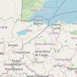
Understand where Sarstoon-Temash National Park sits in Belize through a broader geographic reading of the surrounding landscape, nearby location context, and its mapped position within the national park landscape.

How Sarstoon-Temash National Park fits into Belize

Belize is a Caribbean and Central American nation located on the Yucatán Peninsula's eastern coast. It gained independence from Britain in 1981 and remains a Commonwealth realm with Charles III as monarch. The country features diverse cultures, multiple spoken languages including Belizean Creole, Spanish, and Mayan languages, and is recognized for its rich marine biodiversity including the Mesoamerican Barrier Reef.

Wider geography shaping Sarstoon-Temash National Park in Belize

Belize occupies the eastern coast of the Yucatán Peninsula, stretching approximately 290 kilometres long and 110 kilometres wide. It is bordered by Mexico to the north and west, Guatemala to the south and west, and the Caribbean Sea to the east. The country also shares a maritime boundary with Honduras. The landscape includes coastal plains, swamps, and the Maya Mountains in the interior.

Map view of Sarstoon-Temash National Park

Use this park location map to pinpoint Sarstoon-Temash National Park in Belize, understand its exact geographic position, and read its mapped placement within the surrounding landscape more clearly.

Pigeon | © OpenStreetMap contributors

Location context for Sarstoon-Temash National Park

Toledo District
Park atlas

Compare adjacent national parks and regional conservation landscapes in Belize and Central America

Discover Nearby Protected Areas Around Sarstoon-Temash National Park
Explore other national parks and protected areas near Sarstoon-Temash National Park, tracing the interconnected wetland habitats and diverse ecosystems of Belize's southern region. Compare various conservation landscapes to extend your geographic understanding of Central American protected lands.
National parkToledo District

Payne's Creek National Park: National Park Protected Landscape and Geographic Atlas

Explore mapped boundaries and regional geography in Toledo District.

Payne's Creek National Park serves as a vital protected area within Belize, recognized as a national park. This entry details its specific location within the Toledo District, emphasizing the mapped extent of its protected boundaries. It provides a foundation for understanding the park's geographic character and its role within regional conservation landscapes, ideal for atlas-based discovery.

Area
152 km²
IUCN
II
Relief
Lowland
Climate
Tropical
National parkCayo District

Chiquibul National Park: Detailed Protected Area and National Park Geography

Explore mapped boundaries within Belize's Cayo District.

Chiquibul National Park offers a critical lens through which to view Belize's protected natural areas. As a designated national park located in the Cayo District, it provides essential data for understanding the extent and geographic positioning of conservation landscapes. Users can engage with detailed map information to trace the park's borders and appreciate its role within the national atlas of protected territories.

Area
1,073 km²
Established
1995
IUCN
II
Relief
Mountain
National parkHonduras

Cusuco National Park: Protected Landscape and Geographic Atlas in Honduras

Explore mapped boundaries and regional natural terrain.

Cusuco National Park represents a crucial protected area within Honduras, offering rich detail for geographic exploration. This entry focuses on its identity as a national park, detailing its mapped boundaries and its contribution to the broader landscape context of Central America. Users can discover the specific protected lands and natural terrain that characterize this significant conservation site, building a foundational understanding for atlas-based study.

Area
234.4 km²
Established
1959
IUCN
II
Relief
Mountain
National parkHonduras

Cerro Azul de Copán National Park: Honduras's Highland Cloud Forest Protected Area

Explore mapped geography and montane landscape context.

Cerro Azul de Copán National Park, located in the highlands of western Honduras, is a national park defined by its mountainous terrain and distinctive cloud forest environment. Rising to elevations of over 2,200 meters, the park preserves a crucial highland ecosystem known for its biodiversity and role in watershed protection. Its mapped geography offers insight into the unique montane forest structures and the broader natural landscape of Central America. Discover the protected land's specific environmental characteristics and its place within the region's atlas.

Area
154.6 km²
Established
1987
IUCN
II
Relief
Mountain
National parkCayo District

Elijio Panti National Park: Protected Landscape and Regional Geography in Cayo District

Explore the mapped boundaries and geographic features of this national park.

Elijio Panti National Park offers a unique focus on protected landscape discovery within Belize. Situated in the Cayo District, this national park provides a specific geographic anchor for understanding natural terrain and mapped boundaries. The page details its identity as a protected area, contributing to a structured atlas of conservation lands and regional geography.

Area
52.645 km²
Established
2001
IUCN
II
Relief
Mountain
National parkCayo District

St. Herman's Blue Hole National Park: National Park Protected Landscape and Geographic Setting

Mapped Boundaries and Regional Landscape Context in Cayo District

St. Herman's Blue Hole National Park is an integral protected landscape within Belize, situated in the Cayo District. This national park offers specific geographic features and mapped boundaries essential for understanding its place within regional conservation. MoriAtlas provides detailed context for exploring the park's protected terrain and its contribution to the broader geographic atlas, focusing on landscape identity and mapped outlines for analytical discovery.

Area
2 km²
Established
1986
Climate
Tropical
Access
Easy access
National parkPetén

El Rosario National Park: Protected National Park & Mapped Landscape Explorer

Geographic context and protected area boundaries within Petén.

Delve into the protected landscape of El Rosario National Park, identified as a national park within Guatemala's Petén region. This page provides an atlas-centric view, highlighting its mapped park boundaries and its significance in the regional geography. Understand the park as a distinct protected area contributing to the natural landscape context, ideal for geographic exploration and detailed mapping.

Area
11.05 km²
Established
1980
IUCN
II
Relief
Lowland
National parkCayo District

Guanacaste National Park National Park: Explore its Protected Landscape and Geographic Setting

Mapped natural terrain and regional context within Cayo District.

Delve into the specifics of Guanacaste National Park, a protected national park located in the Cayo District of Belize. This detail page is designed for atlas exploration, offering insights into the park's geographic boundaries and its significance as a defined natural landscape. Understand how this protected area fits into the regional geography and contributes to the mapped natural heritage of Belize.

Area
0.2 km²
Established
1973
IUCN
II
Climate
Tropical

Common questions about visiting, size, designation, and location context for Sarstoon-Temash National Park

Sarstoon-Temash National Park FAQs for park facts, access, geography, and protected area context
Find quick answers about Sarstoon-Temash National Park, including protected-area facts, park geography, trail and visitor context, and how the park fits into its surrounding country and regional landscape.
MoriAtlas Explorer

Continue Your Protected Areas Search Across the Global Atlas

Deepen your exploration by continuing the structured search for national parks and protected areas worldwide. Utilize the comprehensive filtering capabilities to compare different conservation landscapes and refine your understanding of global park geography. Discover more about the distribution and characteristics of protected natural areas.

Global natural geography

