
Rivers
Park geography
Structured data on landscape relief, riverine environments, and spatial dimensions
Comprehensive Geographic Profile and Mapped Boundaries of Shambe National Park in South Sudan
Examine the physical geography and spatial characteristics of Shambe National Park. This profile covers the recorded 620 square kilometer area, lowland terrain, and the influence of the Bahr al Jabal river system on its riverine environment and landscape distribution within South Sudan.
Related tags
national parksavannaWhite Nilebig gameriparian ecosystem
About Shambe National Park
Shambe National Park
Shambe National Park is a protected area in South Sudan, established in 1985 on the west bank of the White Nile in the remote interior of the country. The park covers approximately 620 square kilometers of savanna and riverine landscape in Jonglei State, situated between the Adior and Malek payam administrative areas near the legendary Ramciel. This national park was created primarily to provide legal protection for populations of wild mammals including lions, giraffes, gazelles, monkeys, foxes, and ostriches. The park lies in a region characterized by extensive wetlands, seasonal flooding, and mixtures of grassland and woodland that support diverse wildlife populations. South Sudan's protected area network remains one of the least developed in Africa, and Shambe represents one of the country's attempts to conserve its natural heritage despite significant logistical and political challenges.
- Location
- South Sudan
- Park type
- National park
- Established
- 1985
- Area
- 620 km²
Location overview
Administrative boundaries and inland status for South Sudan protected areas
National Park Geography: Shambe National Park in South Sudan
Shambe National Park is situated within the sovereign territory of South Sudan as a dedicated inland protected area. Geographic records confirm its status as a non-transboundary sanctuary with no marine or coastal boundaries.
- Countries
- South Sudan
- Primary location
- South Sudan
- Geographic setting
- Inland
Boundary and coordinates
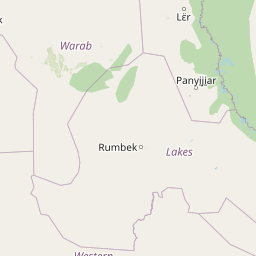
Shambe National Park’s mapped boundary covers 620 km²
Shambe National Park mapped boundary and 620 km² area
Shambe National Park has mapped geometry covering its documented 620 km² extent. The footprint communicates the park’s geographic form, while land, marine area, and perimeter are not separately quantified.
- Boundary area
- 1,772.9 km²
- Boundary perimeter
- 220 km
- Northernmost point
- 7.1812° N
- Southernmost point
- 6.7631° N
- Easternmost point
- 31.1435° E
- Westernmost point
- 30.4737° E
- Geographic centre
- 6.9521° N, 30.7673° E
- North–south span
- 46.2 km
- East–west span
- 74 km
Terrain and natural features
Protected lowland terrain classifications and recorded river networks
Shambe National Park Terrain Mapping and Named Natural Features
Recorded lowland relief classifications define the primary protected terrain, complemented by specific hydrological features located within the park boundary. Linked feature cards supply official names, structural types, and documented spatial relationships.
Selected named natural features
Rivers
Bahr al Jabal
Environmental setting
Analysis of lowland relief, riverine habitats, and sparse forest cover
Shambe National Park Environmental Classifications and Physical Setting
Recorded environmental classifications frame the physical terrain of Shambe National Park as complementary interpretive categories. Connected database records link each stored landscape designation directly to relevant atlas destinations.
- Relief
- Lowland
- Water
- Minor water
- Forest cover
- Sparse forest
Landscape features
Rivers
Habitat types
Riverine habitat
Park atlas
Compare protected landscapes and mapped ecosystems surrounding Shambe National Park.
Explore Nearby National Parks and Protected Areas Beyond Shambe National Park
Browse other national parks and protected areas near Shambe National Park, allowing for geographic comparison of similar savanna and White Nile riverine landscapes. Expand your atlas view to trace the regional spread of conservation efforts, revealing how protected ecosystems connect across South Sudan's diverse terrain.
National parkSouth Sudan
110 km away#1 closest
West

Southern National Park National Park: An Extensive Protected Landscape in South Sudan's Nile Basin
Mapped floodplains, savanna woodlands, and large mammal conservation.
Southern National Park stands as a significant protected area within South Sudan, celebrated for its immense scale and rich ecological tapestry. This national park features a complex mosaic of savanna woodlands, extensive seasonal floodplains carved by the Gel and Ibba rivers, and gallery forests lining river corridors. Its designation as a protected landscape highlights its importance for conserving large mammal populations and preserving the unique wetland ecosystems characteristic of the Nile basin's western reaches, offering a prime focus for geographic and atlas exploration.
- Area
- 23,000 km²
- Established
- 1939
- IUCN
- II
- Relief
- Lowland
National parkSouth Sudan
About 205 km away#2 closest
Southeast
Bandingilo National Park: South Sudan's Protected National Park Identity
Explore its mapped boundaries and East African landscape.
Bandingilo National Park stands as a distinct protected area within South Sudan, contributing to the nation's catalog of national parks. This entry offers a focused atlas perspective, detailing the park's geographic setting and its mapped features. Understand the landscape context and its relation to the surrounding regional geography of East Africa, providing a foundation for structured discovery of protected lands.
- Area
- 10,000 km²
- Established
- 1992
- IUCN
- II
- Relief
- Lowland
National parkDemocratic Republic of the Congo
255 km away#3 closest
Southwest

Garamba National Park: Protected Landscape Atlas and Geographic Context in DRC
Explore Mapped Boundaries of Africa's Historic Savanna Sanctuary
Garamba National Park is a foundational protected area within the Democratic Republic of the Congo, spanning nearly 5,200 square kilometers of distinctive tropical savanna. Established in 1938, this national park is recognized globally as a UNESCO World Heritage Site due to its exceptional biodiversity and role as a critical habitat. The park's landscape is characterized by rolling grasslands, scattered woodlands, and a unique ecological position that supports a rich variety of wildlife, including significant populations of elephants and the DRC's last giraffes. Exploring Garamba National Park through MoriAtlas provides insight into its mapped boundaries, regional geography, and its status as a vital sanctuary for endangered species.
- Area
- 5,200 km²
- Established
- 1938
- IUCN
- II
- Relief
- Lowland
National parkSouth Sudan
About 262 km away#4 closest
South
Lantoto National Park: A Protected National Park in South Sudan's Geography
Explore its mapped boundaries and regional landscape context.
Lantoto National Park represents a critical protected area within the vast geography of South Sudan. As a designated national park, it serves as a focal point for understanding landscape features and conservation efforts within East Africa. This atlas-centric view highlights its mapped presence and the broader regional context it occupies, offering a structured approach to exploring South Sudan's natural terrain and protected lands.
- Area
- 760 km²
- Established
- 1986
- IUCN
- II
- Relief
- Mountain
National parkSouth Sudan
About 309 km away#5 closest
East
Boma National Park: Protected Landscape in South Sudan's East African Geography
Explore mapped boundaries and regional terrain context.
Boma National Park represents a vital protected landscape within South Sudan. As a national park, it contributes significantly to the geographic understanding of conservation areas in East Africa. Its distinct location and mapped outlines provide essential context for those exploring the regional atlas, highlighting its importance in understanding South Sudan's natural terrain and protected area network.
- Area
- 22,800 km²
- Established
- 1977
- IUCN
- II
- Relief
- Lowland
National parkEthiopia
About 333 km away#6 closest
East

Gambela National Park: A Protected National Park within Ethiopia's Geography
Explore mapped landscape features and protected area context.
Gambela National Park represents a vital component of Ethiopia's protected areas network, offering a distinct focus for geographic and atlas exploration. This page provides detailed insights into the park's specific location within Ethiopia, its mapped boundaries, and its significance as a national park. Understand the park's role in the regional landscape and how it contributes to the broader conservation geography of East Africa, providing a valuable resource for structured discovery.
National parkSouth Sudan
About 356 km away#7 closest
South
Nimule National Park: South Sudan's National Park Geography and Protected Boundaries
Explore the terrain and mapped context of this protected landscape.
Nimule National Park represents a key protected area in South Sudan, providing essential geographic data for atlas exploration. This detail page focuses on the park's mapped boundaries, its role as a national park, and its contribution to the regional landscape context of East Africa. Understand the specific terrain and protected land identity that defines this important natural area within the country.
- Area
- 410 km²
- Established
- 1954
- IUCN
- II
- Scope
- Terrestrial
National parkKaramoja
431 km away#8 closest
Southeast

Kidepo Valley National Park: Remote Protected Savannah Landscape in Karamoja
Explore Uganda's expansive national park mapped geography and wildlife
Kidepo Valley National Park represents a significant protected area within the Karamoja region of Uganda. Its rugged terrain features sweeping savannah plains, distinctive granite kopjes, and seasonal river systems, forming a unique geographic tapestry. This park is crucial for understanding the distribution of protected landscapes in East Africa, offering a distinct atlas perspective on its diverse ecosystems and wildlife concentrations across the mapped terrain.
- Area
- 1,442 km²
- Established
- 1958
- IUCN
- II
- Visitors
- 2.3K annual
MoriAtlas Explorer
Continue Exploring Shambe National Park's Geographic and Landscape Context
Delve deeper into the specific geography and protected landscape characteristics of Shambe National Park. Understanding its mapped terrain, riparian ecosystems, and regional setting within South Sudan provides a richer atlas-based perspective on this important conservation area.
Browse next
Global natural geography
Explore related park routes
Explore MoriAtlas Global ParksBrowse All MoriAtlas ParksGlobal Park Map DiscoveryMoriAtlas: Browse All CountriesBrowse All MoriAtlas ContinentsNational Park Environment AtlasGrand Canyon National Park AtlasYellowstone National Park AtlasYosemite National Park Atlas and GeographySerengeti National Park AtlasGalápagos National Park Protected LandscapeBanff National Park Geography and AtlasKruger National Park Atlas EntryUluṟu-Kata Tjuṯa National Park AtlasExplore Uluru-Kata Tjuta National Park GeographyPlitvice Lakes National Park AtlasFiordland National Park Protected LandscapeGreat Smoky Mountains National Park AtlasAfghanistan National Parks and Protected AreasAlbania National Parks and Protected AreasAlgeria National Parks and Protected AreasAmerican Samoa National Parks and Protected AreasAndorra National Parks and Protected AreasAngola National Parks and Protected AreasAntarctica National Parks and Protected AreasAntigua and Barbuda Park List