Mori Atlas logo
Nature reserveShikahogh State Reserve

Examining the mountain forest terrain, river basin hydrology, and regional biodiversity corridors

Shikahogh State Reserve: An Authoritative Geographic Atlas and Protected Landscape Mapping

Shikahogh State Reserve represents one of the most ecologically intact protected landscapes in the southern Caucasus, encompassing over 10,000 hectares of rugged mountain terrain. Located on the flanks of Mount Khustup and the Meghri range within Armenia's Syunik Province, this reserve preserves a continuous broadleaf forest canopy and critical river valley ecosystems. The site acts as a major refuge for diverse Caucasian flora and endemic Zangezur plant species, serving as a primary anchor for regional conservation mapping.

strict nature reserveCaucasian forestbroadleaf forestmountain river valleysendemic floraRed Book species

Shikahogh State Reserve

Nature reserve

Park overview

Structured park overview, official facts, and landscape profile for Shikahogh State Reserve

Shikahogh State Reserve park facts, protected area profile, and essential visitor context

Review the core facts for Shikahogh State Reserve, including designation, size, terrain, visitor scale, habitats, and operating context in one park-focused overview.

About Shikahogh State Reserve

Shikahogh State Reserve lies in the rugged and heavily forested southern part of Armenia, within the Syunik Province near the borderlands with Iran. Covering around 10,330 hectares of mountainous terrain between the southeastern slopes of Mount Khustup and the northeastern slopes of the Meghri range, the reserve encompasses the upper catchments of the Tsav and Shikahogh rivers. Its dramatic relief, deep valleys, and abundant mountain streams and mineral springs define a landscape that contrasts sharply with the more open and deforested zones elsewhere in Armenia.

The reserve was established in 1958 as a strict nature reserve, placing it under the highest level of protection available in the national system, with the explicit purpose of conserving oak, beech, hornbeam, ash, and yew forests along with the associated fauna. Because of its remote location and the stewardship shown by residents of nearby villages, Shikahogh has escaped the most intense waves of post-Soviet deforestation that have reshaped large parts of Armenia's forest cover. Today, roughly 94 percent of its territory remains forested, making it the most significant contiguous block of mature woodland in the country.

Ecologically, Shikahogh forms a critical refuge for southern Caucasus biodiversity. Its flora includes more than a thousand plant species spanning 432 genera and 92 families, with a notable presence of Caucasian-type mesic plants, thermophilic trees and shrubs, and a particularly high concentration of endemics bearing the Zangezur local name, such as the Zangezur pear and Zangezur snowbell. Among its most distinctive features is the only pure yew grove in the Caucasus. The fauna, though not yet fully surveyed, supports brown bears, wolves, lynx, wild boar, roe deer, Caucasian tur, bezoar goats, and rare raptors including Egyptian vultures, alongside reptiles such as the Armenian mountain-steppe shieldhead viper.

Beyond its ecological role, Shikahogh has become a focal point in conservation debates in Armenia, particularly over infrastructure routes proposed through the reserve and the way such projects might fragment habitat and open the forest to logging and poaching. The reserve's significance is therefore both ecological and symbolic, standing as a benchmark for forest protection policy in a country where forest cover has been steadily diminishing.

Quick facts and research context for Shikahogh State Reserve

Shikahogh State Reserve is a strict nature reserve (IUCN Category Ia) in Syunik Province, southern Armenia, established in 1958 and covering about 10,330 hectares. It occupies the upper Tsav and Shikahogh river basins on the southeastern slopes of Mount Khustup and the northeastern slopes of the Meghri range, between approximately 700 and 2,800 meters elevation. About 94 percent of its area is forested, dominated by Caucasian and Georgian oaks, eastern beech, hornbeam, ash, and the Caucasus's only pure yew grove. It harbors around 1,100 plant species, including many endemics of the Zangezur region, as well as large mammals such as brown bear, bezoar goat, Caucasian tur, and occasional Persian leopard.

Protection and recognition

Documented terrestrial protection scope and management records for Shikahogh State Reserve

Shikahogh State Reserve Protection Status and Territorial Designation

Shikahogh State Reserve maintains a documented terrestrial protection scope within its designated conservation boundaries. Official records assemble baseline management data, designation history, and territorial status for rigorous geographic analysis.

Protection details

Protection scope
Terrestrial
Transboundary protection
No
Park context

Deeper park guide and search-rich context for Shikahogh State Reserve

Shikahogh State Reserve history, landscape, wildlife, and travel context

Explore Shikahogh State Reserve through its history, landscape character, ecosystems, wildlife, conservation priorities, cultural context, and seasonal travel timing in a structured park guide built for atlas discovery and search intent.

Why Shikahogh State Reserve stands out

Shikahogh is best known as Armenia's most ecologically intact southern forest refuge, preserving a continuous canopy of Caucasian broadleaf woodland that has largely disappeared elsewhere in the country due to post-Soviet logging. It is recognized for the richness of its Caucasian flora and fauna, including its unique concentration of Zangezur-endemic plants, a rare pure yew grove, and the presence of flagship mammal species such as brown bear and bezoar goat. The reserve is also distinguished biogeographically by its transitional character between the forests of the Lesser Caucasus and the more arid, relict-influenced landscapes of southern Syunik near the Iranian border. This makes Shikahogh significant not only as a national forest refuge but as a regional biodiversity anchor where Caucasian, Mediterranean-influenced, and Iranian floristic elements overlap.
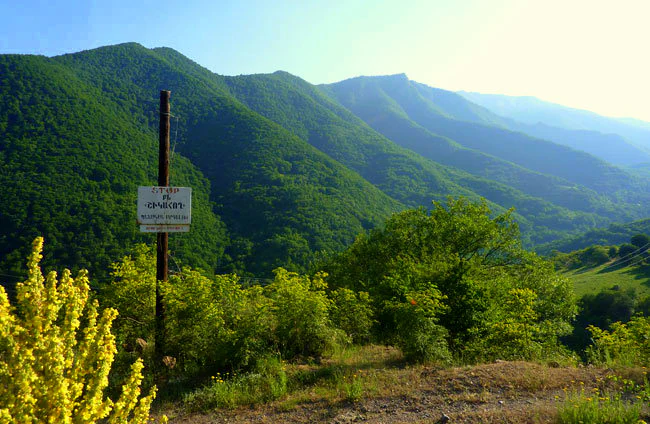
A wide, outdoor shot of green, forested mountains in Shikahogh State Reserve, with a prominent brown wooden sign post on the left foreground amidst yellow wildflowers.
A scenic view of the lush, forested slopes within Shikahogh State Reserve in Armenia, featuring a park entrance sign in the foreground.

Shikahogh State Reserve history and protected-area timeline

Shikahogh was formally established as a state nature reserve in 1958, during the Soviet period, with the explicit aim of conserving representative tracts of oak, beech, hornbeam, ash, and yew forests and the associated animal populations of southern Armenia. Its status as a strict nature reserve placed it within the highest tier of Soviet-era protected-area categories, restricting economic use within its boundaries.

Following Armenian independence and the collapse of the Soviet forestry system, much of the country's remaining forest cover came under intense pressure from logging, fuelwood harvesting, and unregulated land use. Environmentalists have noted that Shikahogh has been one of very few Armenian forest reserves to remain largely intact in this period, due to a combination of its remote location in the southern Syunik mountains and the stewardship of nearby rural communities. As a result, the reserve has come to function as the de facto reference site for what undisturbed southern Armenian forest looks like in the post-Soviet landscape.

Since the early 2000s, Shikahogh has also featured prominently in environmental policy debates, especially around proposals for road construction through the core of the reserve. Conservationists, women's associations, and ecological NGOs have argued that any such infrastructure would bisect the protected area, increase poaching and logging access, and intensify disturbance and pollution from heavy vehicle traffic. The controversy has helped position Shikahogh as a national symbol of the tensions between infrastructure development and the protection of Armenia's shrinking forest estate.

Shikahogh State Reserve landscape and geographic character

The landscape of Shikahogh is shaped by strong vertical relief, with elevations ranging from roughly 700 meters in the deep river valleys to about 2,800 meters along the upper slopes of the surrounding massifs. The southeastern flanks of Mount Khustup drop steeply into forested ravines, while the northeastern slopes of the Meghri range create a secondary wall of ridges and intervening valleys. Between them lies the upper catchment of the Tsav and Shikahogh rivers, a network of narrow mountain streams that dissect the terrain into a highly fragmented relief.

Mineral springs are abundant across the reserve, and rocky outcrops, steep slopes, and shaded gorges are recurring visual features. The combination of elevation range, aspect differences between north- and south-facing slopes, and proximity to the Iranian border gives the area a transitional climatic character, where southern Caucasian forest vegetation encounters more xeric and thermophilic influences. The resulting scenery is one of dense, often almost unbroken forest canopy interrupted by deep valleys, cliff lines, and occasional high-elevation openings.

Shikahogh State Reserve ecosystems, habitats, and plant life

The reserve's natural character is dominated by mature Caucasian broadleaf forest, with about 94 percent of the area under continuous tree cover. Forest-forming species include eastern and common beech, Georgian and large-fruited oak, Caucasian hornbeam, ash, and the extraordinarily rare eastern yew, which forms the only pure yew grove in the Caucasus. Below and alongside these dominant trees grow wild pear, eastern apple, Greek wild walnut, bird cherry, maple, linden, and wild plum, creating multi-layered woodland with a rich understory of shrubs such as Pontic rhododendron, chestnut-leaved oak, Caucasian whortleberry, pomegranate, fig, and hazel.

The herbaceous and moss layer is likewise diverse. Eighteen rare moss species have been recorded, with the delicate Buxbaumia aphylla type Fabronia among the most notable. The flora spans 1,100 species across 432 genera and 92 families, of which around 70 are listed in Armenia's Red Book. A defining feature is the concentration of Zangezur endemics, plants whose local names reference the historic Zangezur region, such as the Zangezur pear and Zangezur snowbell, alongside other Caucasian and Caucasian-type mesic and thermophilic species. The reserve sits at an ecological crossroads where Caucasian forest communities meet more thermophilic southern and Iranian-influenced elements.

Shikahogh State Reserve wildlife and species highlights

Shikahogh's wildlife profile reflects the reserve's largely unbroken forest cover, rugged relief, and relatively undisturbed character. Large mammals include the brown bear, grey wolf, lynx, wild boar, roe deer, grey hare, and Caucasian tur, with occasional records of bezoar goat, wild sheep, and the highly elusive Persian leopard, which gives the reserve particular conservation significance within the Caucasus.

The avifauna is similarly diverse, with resident and seasonal species ranging from wild turkey to raptors such as the Egyptian vulture and white-headed and black vultures. The reptile fauna includes the Gyurza, water and common tortoises, the yellow-bellied snake, and the Armenian mountain-steppe shieldhead viper, an endemic of regional conservation concern. Many of these animal species, like a significant share of the flora, are recorded in Armenia's Red Book, and the reserve is widely regarded as one of the country's most important sanctuaries for southern Caucasian forest fauna, even though full faunal inventories are still incomplete.

Shikahogh State Reserve conservation status and protection priorities

Shikahogh's conservation significance extends far beyond its local forest-protection role. As Armenia's most ecologically intact southern forest reserve, it preserves a contiguous canopy and associated wildlife community that has largely vanished elsewhere in the country, providing a baseline for understanding the original character of Armenian forests before decades of post-Soviet logging and land-use change. Its high share of Red Book species, both plant and animal, underscores its role as a refuge for nationally and regionally threatened biodiversity.

The reserve also carries strong biogeographical importance. Located within the southern Caucasus and bordering the Iranian highlands, it supports a transitional flora and fauna in which Caucasian forest endemics coexist with thermophilic and relict southern elements. The presence of flagship species such as brown bear and bezoar goat, and the occasional occurrence of the Persian leopard, lend Shikahogh weight in regional conservation planning for the wider Caucasus.

Crucially, the reserve has become a touchstone for forest conservation policy in Armenia. Proposed infrastructure projects, most notably a highway through the reserve's core, have triggered sustained criticism from environmental groups, women's organizations, and local communities because of the risks of fragmenting habitat, opening access to poachers and loggers, and introducing heavy traffic into a strict nature reserve. The ongoing debate over Shikahogh highlights the broader challenge of balancing development with the protection of natural heritage in countries with limited and rapidly diminishing forest cover.

Shikahogh State Reserve cultural meaning and human context

Shikahogh's cultural context is closely tied to its surrounding rural communities in southern Syunik, particularly villages such as Mtnadzor, whose residents have historically played a notable role in protecting the forest from logging. Local civil society, including women's associations such as the Saint Sandukht Women's Union and social-ecological organizations, has been vocal in defending the reserve against externally driven development pressures, framing Shikahogh not only as an ecological resource but as a community-held natural heritage of national significance.

Top sights and standout views in Shikahogh State Reserve

Among Shikahogh's standout features is its near-complete forest cover, its exceptional plant diversity with more than 1,100 recorded species, and its unique concentration of Zangezur endemics and Caucasian forest types not found elsewhere in Armenia in such condition. The reserve contains the Caucasus's only pure yew grove and supports mammal populations such as brown bear, bezoar goat, Caucasian tur, and occasional Persian leopard, making it one of the most ecologically significant protected areas in the southern Caucasus.

Best time to visit Shikahogh State Reserve

The reserve is best appreciated during the warmer months from late spring through autumn, when mountain roads and trails are more reliably accessible and the forest is in full leaf, offering the most vivid experience of its dense broadleaf canopy. Spring brings fresh growth and active birdlife, while autumn highlights the seasonal color change across the mixed oak, beech, and hornbeam forests. Winter conditions in the upper elevations can be severe, with heavy snow and limited access, so visits during this period require careful preparation. Because of its strict nature reserve status, any on-site visit must respect protection regulations.

Monthly climate preview

Long-term representative point measurements tracking monthly temperature and precipitation cycles

Shikahogh State Reserve Climate Normals and Annual Temperature Rhythm

Representative coordinates record sustained thermal variation and measured daily precipitation rates across the twelve-month climatology cycle. Deeper monthly climate profiles provide full access to historical temperature ranges and precipitation normals for Shikahogh State Reserve.
Annual mean8 °C
-4 °C19 °C
Jan-4°
Feb-3°
Mar
Apr
May13°
Jun17°
Jul19°
Aug19°
Sep15°
Oct10°
Nov
Dec-2°
Warmest month
July

19.3 °C

Coolest month
January

-4.3 °C

Wettest month
May

1.2 mm/day

Driest month
August

0.2 mm/day

Park location guide

Geography guide, regional context, and park location map for Shikahogh State Reserve

Shikahogh State Reserve park geography, regions, and map view in Armenia

Understand where Shikahogh State Reserve sits in Armenia through a broader geographic reading of the surrounding landscape, nearby location context, and its mapped position within the national park landscape.

How Shikahogh State Reserve fits into Armenia

Armenia is a landlocked nation in the South Caucasus region of West Asia, located in the Armenian highlands. It shares borders with Turkey to the west, Georgia to the north, Azerbaijan to the east, and Iran and the Nakhchivan exclave to the south. Yerevan is the capital and largest city. Armenia was the first country to adopt Christianity as its official religion in AD 301 and maintains the Armenian Apostolic Church as its primary religious institution.

Wider geography shaping Shikahogh State Reserve in Armenia

Armenia is situated in the South Caucasus region of West Asia, occupying the Armenian highlands. It is bordered by Turkey to the west, Georgia to the north, Azerbaijan to the east, and Iran and the Nakhchivan Autonomous Republic to the south. The country is landlocked, though it historically had access to the Caspian Sea.

Map view of Shikahogh State Reserve

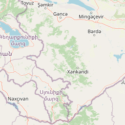
Use this park location map to pinpoint Shikahogh State Reserve in Armenia, understand its exact geographic position, and read its mapped placement within the surrounding landscape more clearly.

Pigeon | © OpenStreetMap contributors

Location context for Shikahogh State Reserve

Syunik Province

Visual reference of rugged terrain, broadleaf woodlands, and river valleys

Shikahogh State Reserve Photos, Mountain Landscapes, and Protected Scenery

Visual documentation captures the rugged mountain topography, unbroken forest canopy, and steep river gorges defining Shikahogh State Reserve. Photographic records reveal the protected area environment, dense vegetation types, and diverse terrain features across the southern Armenian landscape.

A wide, outdoor shot of green, forested mountains in Shikahogh State Reserve, with a prominent brown wooden sign post on the left foreground amidst yellow wildflowers.

A panoramic landscape view of green, forested mountains under a bright sky, with a tall wooden post featuring a white sign in the foreground and yellow wildflowers to the left.

Park atlas

Compare southern Armenian forest reserves and connected mountain habitats

Other Parks Near Shikahogh State Reserve and Regional Protected Landscapes

Continue exploring protected areas near Shikahogh State Reserve by comparing adjacent mountain forests and river valley ecosystems. Regional park data reveals broader ecological patterns across the rugged terrain of southern Syunik Province.
Nature reserveZangilan District
About 14 km away#1 closest

East

Basut-Chay State Reserve: Regional Geography and Protected Forest Landscape Atlas

Nature reserve in the Lesser Caucasus of Azerbaijan

Basut-Chay State Reserve protects a significant riverine landscape dominated by centuries-old Oriental plane trees. Located within the Zangilan District, the area showcases a compact ecological gradient featuring alluvial river terraces and steep mountain slopes. This strict nature reserve provides a essential reference for studying Caucasian floodplain forest remnants and mountain valley topography.

Area
1.07 km²
Established
1974
IUCN
Ia
Relief
Mountain
Watercolor illustration showing mountains, green forests, and a winding river under a soft pink sky.
National parkSyunik Province
About 16 km away#2 closest

West

Arevik National Park: Syunik Province's Protected Mountain Landscape and Biodiversity Atlas

Explore mapped boundaries, terrain, and ecosystems.

Arevik National Park offers a detailed look into the geography and protected landscape of Armenia's Syunik Province. This park is defined by the rugged Zangezur mountains and its remarkable vertical ecological zoning, transitioning from semi-desert to alpine environments. Examine its mapped terrain, significant butterfly and bird habitats, and the presence of key mammal species, providing a comprehensive atlas-style understanding of this protected area's natural identity.

Area
344 km²
Established
2009
IUCN
II
Relief
Mountain
Watercolor illustration of a mountainous landscape with green fields, a river, and a sunset sky
National parkOrdubad District
About 47 km away#3 closest

West

Zangezur National Park: National Park and Protected Mountain Wilderness in Ordubad District

Explore dramatic glacial terrain and the highest Lesser Caucasus peaks.

Zangezur National Park encompasses a significant portion of the Zangezur mountain range, presenting a striking high-altitude protected landscape within Ordubad District, Azerbaijan. Its geography is characterized by rugged alpine features, extensive glacial formations, and dramatic elevation changes culminating in the Gemiqaya summit. This park serves as a vital refuge for diverse ecosystems and is distinguished by its role in preserving the highest mountain terrain in Azerbaijan's Lesser Caucasus, offering a unique focal point for geographic and protected-area exploration.

Area
427.97 km²
Established
2003
IUCN
II
Relief
Mountain
Nature reserveAzerbaijan
About 91 km away#4 closest

Northwest

Gara-Gel State Reserve: Mapping the Protected Volcanic Landscapes of Azerbaijan

High-altitude nature reserve with glacial and volcanic crater geography.

Gara-Gel State Reserve represents a concentrated protected area built around Lake Ishigli-Gara-Gel. Situated at nearly 2,700 meters, this site showcases the convergence of volcanic geology and mountain botany. The landscape features meadows and steep slopes that define the character of this protected highland basin, offering significant insight into the transitional ecosystems found within the broader Karabakh plateau.

Area
2.4 km²
Established
1987
Relief
Mountain
Climate
Alpine
National parkGegharkunik Province
About 146 km away#5 closest

Northwest

Sevan National Park: High-Altitude Lake and Protected Landscape in Gegharkunik

Explore map context, park boundaries, and regional geography.

Sevan National Park is a vital protected area located in Armenia's Gegharkunik Province, primarily safeguarding the remarkable high-altitude Lake Sevan. Established to protect this significant freshwater ecosystem, the park encompasses diverse surrounding landscapes including wetlands, forests, and steppes. Users exploring this canonical park detail page can delve into its geographic setting within the Armenian highlands, understand its importance as a protected landscape, and access structured data relevant to its unique natural environment. This MoriAtlas entry offers a focused lens on the park's conservation status and its contribution to regional geography.

Area
342 km²
Established
1978
IUCN
II
Relief
Highland
National parkAzerbaijan
About 149 km away#6 closest

Northeast

Ag-Gel National Park

Azerbaijan Protected Wetland & Bird Sanctuary

Ag-Gel National Park is a protected wetland significant for migratory birds. Its landscape features a complex lake system and extensive reed beds, making it a vital conservation area in the Caspian region.

Area
179.24 km²
Established
2003
IUCN
II
Relief
Lowland
Watercolor illustration of a lake surrounded by greenery with mountains in the background
National parkAzerbaijan
About 152 km away#7 closest

North

Göygöl National Park: Iconic Alpine Lakes and Protected Caucasus Forest Landscape

Explore Azerbaijan's most visited national park and its rich geographic context.

Göygöl National Park is a key protected area in Azerbaijan, renowned for the crystal-clear alpine Lake Göygöl and its surrounding dense forests within the Lesser Caucasus mountains. This national park showcases over 420 plant species, significant wildlife populations, and dramatic mountainous terrain, making it a prime destination for understanding regional landscape diversity and protected land value. Use MoriAtlas to explore its mapped boundaries and connect it to the broader geographic context of Azerbaijan.

Area
127.55 km²
Established
2008
IUCN
II
Relief
Mountain
A horizontal watercolor painting depicting rolling green hills, distant mountains, and sparse vegetation.
Nature reserveArarat Province
About 162 km away#8 closest

Northwest

Khosrov Forest State Reserve: Mapping Armenia's Historic Nature Reserve and Mountain Geography

Explore ancient juniper forests and rugged canyon terrain in Ararat Province.

Khosrov Forest State Reserve is a critical protected landscape in Armenia defined by its remarkable elevational gradient. From semi-desert lowlands to high mountain meadows, the reserve encompasses unique Tertiary relict forests and river-cut gorges. This resource maps the park's boundaries and provides a clear geographic overview of its diverse ecosystems and cultural heritage within the Ararat Province.

Area
232.13 km²
Established
1958
IUCN
Ia
Relief
Mountain

Common questions about visiting, size, designation, and location context for Shikahogh State Reserve

Shikahogh State Reserve FAQs for park facts, access, geography, and protected area context

Find quick answers about Shikahogh State Reserve, including protected-area facts, park geography, trail and visitor context, and how the park fits into its surrounding country and regional landscape.
MoriAtlas Explorer

Continue Your Protected Areas Search Across the Global Atlas

Deepen your exploration by continuing the structured search for national parks and protected areas worldwide. Utilize the comprehensive filtering capabilities to compare different conservation landscapes and refine your understanding of global park geography. Discover more about the distribution and characteristics of protected natural areas.

Global natural geography