Why Shiretoko National Park stands out
Shiretoko is best known for harboring Japan's largest population of brown bears, with the peninsula supporting one of the highest densities of this iconic species anywhere in the country. The park is also renowned for its dramatic coastal scenery, where sheer cliffs meet the productive waters of the Sea of Okhotsk, creating opportunities to observe marine mammals including spotted seals, orcas, and sperm whales. The area is a critical habitat for Steller's sea eagle and white-tailed eagle, two of Japan's most impressive raptors. The park offers rare views toward Kunashiri Island, part of the disputed Kuril Islands, adding geopolitical dimension to the landscape.
Shiretoko National Park history and protected-area timeline
Shiretoko National Park was established on June 1, 1964, as part of Japan's growing post-war commitment to nature conservation. The designation came during a period when Japan was systematically identifying and protecting its most significant natural areas, following the earlier establishment of Nikko and Nikoyama national parks in the 1930s. In 2005, the park achieved international recognition when UNESCO inscribed it as a World Heritage Site, citing its outstanding natural value under criteria ix and x related to ecological processes and biodiversity conservation. The World Heritage listing noted the potential for developing the property as a transboundary peace park with Russia's Kuril Islands, though this collaborative framework has not yet been realized. The designation generated controversy among the indigenous Ainu people, who pointed to their long history of settlement and cultural connection to the Shiretoko landscape, arguing that the natural heritage recognition overlooked their human heritage.
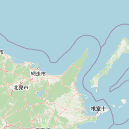
Shiretoko National Park landscape and geographic character
The Shiretoko Peninsula presents a landscape of remarkable vertical contrast, with terrain rising sharply from sea level to mountain ridges that form the spine of this narrow landform. The coastline features some of Hokkaido's most dramatic cliffs, where basalt columns and erosion-carved formations meet the productive waters of the Sea of Okhotsk. The peninsula's interior contains a series of volcanic peaks including Mount Rausu, whose slopes support the park's extensive forest cover. The landscape is dissected by numerous streams that descend from the uplands, cutting through forested valleys before reaching the sea. The Kamuiwakka Falls represent a unique geological feature where hot spring water emerges from volcanic strata and cascades directly into the ocean, creating a rare geothermal coastal waterfall.
Shiretoko National Park ecosystems, habitats, and plant life
The forests of Shiretoko represent a transition between temperate and subalpine zones, with species composition reflecting the peninsula's northerly position and the influence of continental climates from the Asian mainland. Sakhalin fir dominates the coniferous component of the forests, while Erman's birch and Mongolian oak provide the deciduous element in this mixed forest ecosystem. Above the forest limit, which varies with elevation and exposure, dense thickets of Siberian dwarf pine form a nearly impassable barrier across the high ridges. The park's marine environments are strongly influenced by the cold Sea of Okhotsk, which supports productive food chains that sustain diverse marine mammals and seabirds. The interface between terrestrial and marine ecosystems here is particularly dynamic, with no buffer zones separating the forest from the rocky coastline.
Shiretoko National Park wildlife and species highlights
Shiretoko harbors Japan's most significant population of brown bears, with the peninsula supporting densities that are unmatched elsewhere in the country. These apex predators move freely across the landscape, utilizing both the forest interior and coastal areas where they forage for marine foods including fish and shellfish. The park's avian fauna includes impressive concentrations of Steller's sea eagles and white-tailed eagles, which winter along the coast and feed on fish and carrion. Marine mammals are a major attraction, with spotted seals breeding on the offshore ice and orcas and sperm whales commonly seen in the surrounding waters. The ecosystem supports a complete food web from primary producers through apex predators, making it one of Japan's most ecologically intact protected areas.
Shiretoko National Park conservation status and protection priorities
Shiretoko's World Heritage designation recognizes that the park represents one of Japan's last remaining wilderness areas where natural processes continue largely without significant human interference. The high density of brown bears reflects the health of the ecosystem and the effectiveness of protection measures that have limited human disturbance in core areas. The marine environment receives protection as an integral part of the park, recognizing that the ecological integrity of the peninsula depends on the health of the surrounding sea. The potential for a transboundary World Heritage site linking Shiretoko with Russia's Kuril Islands reflects the ecological continuity across this maritime boundary, though political differences have prevented such collaboration.
Shiretoko National Park cultural meaning and human context
The Shiretoko Peninsula has been home to the Ainu people for generations, and the park's name itself derives from the Ainu language. The Ainu have maintained deep cultural connections to this landscape, which provided traditional foods, materials, and spiritual meaning. The controversy surrounding the World Heritage designation highlighted ongoing tensions between conservation frameworks that emphasize wilderness and indigenous peoples who have shaped and been shaped by these landscapes over centuries. The Ainu perspective emphasizes that Shiretoko has never been a wilderness in the sense of being untouched by human presence, but rather a cultural landscape where human and natural communities have co-evolved.
Top sights and standout views in Shiretoko National Park
Shiretoko offers Japan's most reliable opportunities to observe brown bears in the wild, with viewing programs operating during the salmon season when bears congregate at coastal streams. The peninsula provides exceptional birdwatching, particularly for Steller's sea eagles and white-tailed eagles that winter along the coast. The Kamuiwakka hot springs waterfall presents a unique geological phenomenon where geothermal waters meet the sea. Hiking the peninsula's trails reveals a progression from coastal cliffs through old-growth forest to subalpine vegetation. The remote character of the area, accessible only by foot or boat, ensures a wilderness experience increasingly rare in Japan.
Best time to visit Shiretoko National Park
The optimal season for visiting Shiretoko runs from late spring through early autumn, with June through October offering the most reliable access to trails and wildlife viewing opportunities. The summer months bring extended daylight and relatively mild temperatures ideal for hiking, while autumn offers spectacular fall color in the deciduous forests. Winter access is severely limited due to heavy snowfall and the remote nature of the peninsula, though the frozen landscape has its own stark beauty. Wildlife viewing intensifies during the salmon running season in late summer and early autumn, when brown bears are most active along coastal streams.