Mori Atlas logo
National parkShomron National Park

Discover the mapped terrain and natural features of this key protected area.

Shomron National Park: Protected Landscape and Geographic Context in the Samarian Highlands

Shomron National Park stands as a protected area within the Samarian highlands, safeguarding the natural terrain and archaeological heritage of the ancient region. This page offers an atlas-oriented view of the park, highlighting its landscape character, the distribution of its protected boundaries, and its role in the geography of the West Bank highlands. Explore the mapped context of this significant protected landscape.

West Bank parksArchaeological protected areasMediterranean highlandsNature reservesSamarian regionHistorical sites

Shomron National Park

National park

Park overview

Structured park overview, official facts, and landscape profile for Shomron National Park

Shomron National Park park facts, protected area profile, and essential visitor context

Review the core facts for Shomron National Park, including designation, size, terrain, visitor scale, habitats, and operating context in one park-focused overview.

About Shomron National Park

Shomron National Park is a protected natural area established in the Samarian highlands of the West Bank. The park serves to preserve both the natural landscape and archaeological heritage of the region historically known as Samaria. This area has long been of historical significance due to its strategic location in the central highlands of the region. The protected area contributes to the network of nature reserves in the West Bank that aim to preserve natural landscapes and historical sites.

Quick facts and research context for Shomron National Park

Shomron National Park is situated in the central West Bank highlands, an area of historical and strategic importance. The protected area spans terrain associated with the ancient Samaritan region. This reserve represents one of the protected areas in the West Bank that attempts to preserve both archaeological heritage and natural landscapes.

Protection and recognition

Verifying the official terrestrial management framework and global recognition status

Documented Protection Status and Terrestrial Designation of Shomron National Park

Official data outlines the terrestrial protection status and management scope of Shomron National Park within the regional conservation landscape. Tracking documented designations helps researchers and conservation enthusiasts understand how specific natural geographies align with global protective frameworks.

Protection details

Protection scope
Terrestrial
Transboundary protection
No
Park context

Deeper park guide and search-rich context for Shomron National Park

Shomron National Park history, landscape, wildlife, and travel context

Explore Shomron National Park through its history, landscape character, ecosystems, wildlife, conservation priorities, cultural context, and seasonal travel timing in a structured park guide built for atlas discovery and search intent.

Why Shomron National Park stands out

The park is known for preserving the landscape of the ancient Samarian region and protecting archaeological and natural sites within the West Bank highlands.

Shomron National Park history and protected-area timeline

The establishment of Shomron National Park reflects broader efforts in the region to designate and protect areas of natural and historical significance. Protected area designation in this region has faced various administrative and political challenges. The park was created as part of conservation efforts to preserve the Samarian highland landscape and associated cultural heritage.

Shomron National Park landscape and geographic character

The park encompasses terrain characteristic of the Samarian highlands, featuring rolling hills, rocky outcrops, and Mediterranean-type vegetation zones. The landscape reflects the geological formations and climate patterns typical of the central West Bank elevated regions.

Shomron National Park ecosystems, habitats, and plant life

The natural environment of Shomron National Park includes Mediterranean forest and shrubland ecosystems typical of the highlands region. The area supports native plant communities adapted to the climate and terrain of the Samarian hills.

Shomron National Park wildlife and species highlights

The park provides habitat for wildlife species typical of the Mediterranean highland ecosystems in this part of the West Bank. Local fauna includes various bird species, small mammals, and reptiles adapted to the rocky terrain and scrubland habitat.

Shomron National Park conservation status and protection priorities

The park contributes to regional conservation efforts aimed at preserving the natural and cultural heritage of the Samarian highlands. Protected area management in this region addresses both ecological preservation and archaeological site protection.

Shomron National Park cultural meaning and human context

The Shomron region holds significant historical and cultural importance, being associated with the ancient Kingdom of Samaria and various historical periods. The area has been inhabited and cultivated for millennia, leaving layers of archaeological and cultural significance in the landscape.

Top sights and standout views in Shomron National Park

The park preserves the natural landscape of the Samarian highlands while protecting associated archaeological and cultural sites. It represents an important component of the West Bank's protected area network.

Best time to visit Shomron National Park

The optimal time to visit would typically be during the spring and autumn months when weather conditions in the highlands are moderate and comfortable for outdoor exploration.

Monthly climate preview

Track monthly temperature ranges and precipitation averages across the protected landscape

Shomron National Park Climate Normals and Long-Term Temperature Patterns

Representative coordinate records show average temperatures ranging from 12.66 degrees Celsius in January to 27.1 degrees Celsius in August alongside shifting daily precipitation levels. Examining the complete twelve-month climatology provides deeper insight into measured thermal ranges and long-term weather patterns across the protected terrain.
Annual mean20 °C
13 °C27 °C
Jan13°
Feb13°
Mar15°
Apr18°
May21°
Jun24°
Jul27°
Aug27°
Sep26°
Oct23°
Nov19°
Dec15°
Warmest month
August

27.1 °C

Coolest month
January

12.7 °C

Wettest month
January

3.9 mm/day

Driest month
August

0 mm/day

Park location guide

Geography guide, regional context, and park location map for Shomron National Park

Shomron National Park park geography, regions, and map view in Palestine

Understand where Shomron National Park sits in Palestine through a broader geographic reading of the surrounding landscape, nearby location context, and its mapped position within the national park landscape.

How Shomron National Park fits into Palestine

The State of Palestine is a country in West Asia formed from the West Bank and Gaza Strip, both under Israeli occupation. Declared independent in 1988, it is recognized by 157 UN member states and serves as the national entity for the Palestinian people. Ramallah serves as the de facto administrative center while Jerusalem's status remains contested.

Wider geography shaping Shomron National Park in Palestine

Palestine is located in the Levant region of West Asia. The West Bank borders Jordan to the east and Israel to the west and south, while the Gaza Strip borders Egypt to the southwest and Israel to the east. The terrain varies from plains along the coast to hills and mountains in the interior.

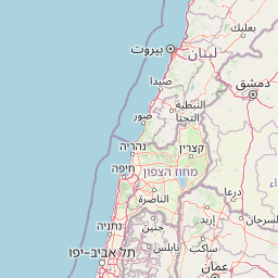
Map view of Shomron National Park

Use this park location map to pinpoint Shomron National Park in Palestine, understand its exact geographic position, and read its mapped placement within the surrounding landscape more clearly.

Pigeon | © OpenStreetMap contributors
Park atlas

Map the spread of protected landscapes, nature reserves, and historical sites across the West Bank.

Discover Other Protected Areas and Regional Parks Near Shomron National Park

Explore national parks, nature reserves, and archaeological sites that share geographic context with Shomron National Park across the Samarian highlands. Trace their protected landscapes, compare regional terrain, and understand the spread of conservation efforts in the West Bank's elevated regions.
National parkIsrael
About 31 km away#1 closest

Southwest

Yarkon-Tel Afek National Park: Explore Its Protected Landscape and Israeli Geography

Mapped protected area and natural terrain context.

Gain a structured understanding of Yarkon-Tel Afek National Park, a designated national park within Israel. This detail entry focuses on its geographic identity and role as a protected landscape, providing essential context for atlas exploration. Understand the park's mapped boundaries and its contribution to the natural geography of the region without extraneous visitor details.

Scope
Terrestrial
Water
Minor water
National parkIsrael
About 33 km away#2 closest

Northwest

HaSharon Park National Park: Geographic Atlas and Protected Landscape Exploration in Israel

Discover the mapped terrain and regional context of HaSharon Park.

HaSharon Park is a national park providing a distinct protected landscape within Israel's borders. This entry supports a deeper understanding of its geographic setting and mapped natural terrain, contributing to the broader atlas of protected areas in the region. Users can explore the park's boundaries and its place within the national geography, gaining insights into the protected lands that characterize this part of the Levant.

Relief
Lowland
Access
Easy access
Scope
Terrestrial
Water
Major water bodies
Watercolor painting of a river surrounded by grassy fields and distant hills with trees
National parkIsrael
About 34 km away#3 closest

Northwest

Alexander River National Park: Israel's Protected Coastal Wetland and Sea Turtle Conservation Hub

Mapped riparian geography and vital protected landscape in Israel.

Alexander River National Park is a significant protected coastal wetland in Israel, focusing on the preservation of the lower Alexander River's unique riparian ecosystem. Renowned for its thriving populations of African softshell turtles and its role as the National Sea Turtle Rescue Center for endangered green sea turtles, the park offers a compelling case study in environmental rehabilitation. Users can explore the park's mapped boundaries, understand its geography as a transition zone between freshwater and marine environments, and appreciate its importance within the broader landscape of Mediterranean protected areas.

IUCN
V
Relief
Lowland
Climate
Mediterranean
Scope
Mixed
National parkIsrael
About 34 km away#4 closest

North

Tel Megiddo National Park: Israel's Protected National Park Landscape

Explore the mapped geography and protected area context.

Delve into the specific geographic features and protected landscape identity of Tel Megiddo National Park, a key national park within Israel. This atlas entry focuses on the park's mapped boundaries and its contribution to the regional conservation context, offering a clear view of its terrain and natural setting for dedicated geographic discovery.

National parkIsrael
About 35 km away#5 closest

Northeast

Beit Alfa Synagogue National Park: A Protected Landscape in Israel's Geography

Explore the mapped natural terrain and park boundaries.

This page details Beit Alfa Synagogue National Park, a designated national park in Israel, offering an atlas-centric view of its protected landscape. Understand its geographic setting and the mapped context of its protected area within the region. MoriAtlas provides structured data to explore the natural terrain and park boundaries of Beit Alfa Synagogue National Park, enriching your understanding of Israel's conservation lands.

Scope
Terrestrial
Water
No major water
National parkIsrael
About 35 km away#6 closest

Northeast

Gan HaShlosha National Park: Protected Landscape and Archaeological Atlas in Israel

Explore natural springs, waterfalls, and ancient ruins within this national park.

Gan HaShlosha National Park presents a remarkable protected landscape in Israel, distinguished by its warm, natural spring-fed pools and picturesque waterfalls. This national park serves as a vital oasis within the Jordan Valley, boasting lush vegetation and a unique microclimate. Visitors can explore the park's archaeological heritage, featuring ruins that speak to its long history of human habitation. Understanding Gan HaShlosha National Park through its mapped geography and protected-area context provides valuable insight into Israel's natural and historical landscapes.

IUCN
V
Scope
Terrestrial
National parkIsrael
About 38 km away#7 closest

Northeast

Beit She'an National Park: A Protected Landscape in Israel's National Park Atlas

Mapped geographic context and protected area boundaries.

Beit She'an National Park offers a unique perspective on protected lands within Israel. This detail page provides users with insights into the park's specific geographic setting and its role as a mapped natural landscape. Delve into the structured data surrounding Beit She'an National Park to understand its protected status and its contribution to the broader atlas of conservation areas in the region, offering a grounded view of its terrain and spatial significance.

Nature reserveJericho Governorate
About 41 km away#8 closest

Southeast

Ain Al-Auja Nature Reserve: Mapping the Oasis Geography and Protected Ecosystems

Desert oasis and freshwater spring landscapes in Jericho Governorate

Ain Al-Auja Nature Reserve offers a distinct look at the intersection of highland escarpments and valley floor water systems. The protected landscape, defined by its perennial spring and surrounding medicinal flora, functions as a vital green corridor. View the mapped boundaries and terrain context of this significant desert oasis within the Jordan Valley network.

Area
22 km²
Access
Access unknown
Scope
Terrestrial
Water
Major water bodies

Common questions about visiting, size, designation, and location context for Shomron National Park

Shomron National Park FAQs for park facts, access, geography, and protected area context

Find quick answers about Shomron National Park, including protected-area facts, park geography, trail and visitor context, and how the park fits into its surrounding country and regional landscape.
MoriAtlas Explorer

Continue Your Protected Areas Search Across the Global Atlas

Deepen your exploration by continuing the structured search for national parks and protected areas worldwide. Utilize the comprehensive filtering capabilities to compare different conservation landscapes and refine your understanding of global park geography. Discover more about the distribution and characteristics of protected natural areas.

Global natural geography