

Mori Atlas logo
National parkSi Phang-nga National Park

Discover the park's unique limestone karst formations, mangrove forests, and coastal geography.

Si Phang-nga National Park: A Geographically Distinct Protected Landscape in Phang Nga Province

Si Phang-nga National Park represents a remarkable protected landscape within Thailand's Phang Nga Province, defined by its dramatic limestone karst topography and extensive mangrove ecosystems along the Andaman Sea. This national park offers a unique opportunity to explore a geologically ancient environment shaped by millions of years of erosion, featuring towering karst pinnacles, intricate cave systems, and labyrinthine tidal channels. Understanding Si Phang-nga National Park's position within its regional geography provides critical context for appreciating its ecological significance and distinct natural features.

limestone karstmangrove forestscoastal protected areacave systemsThailand national parksAndaman Sea

Si Phang-nga National Park

National park

Park overview

Structured park overview, official facts, and landscape profile for Si Phang Nga National Park

Si Phang Nga National Park park facts, protected area profile, and essential visitor context

Review the core facts for Si Phang Nga National Park, including designation, size, terrain, visitor scale, habitats, and operating context in one park-focused overview.

About Si Phang Nga National Park

Si Phang Nga National Park protects a remarkable coastal landscape where geology and ecology intersect to create one of Thailand's most distinctive protected areas. The park's limestone karst formations, some reaching heights of over 300 meters, represent a complex geological history spanning millions of years of tectonic activity and erosion. These dramatic rock formations are interspersed with mangrove forests that thrive in the tidal zones, creating a dynamic interface between terrestrial and marine environments. The park's location on the Andaman coast places it within a broader region recognized for its exceptional natural beauty and biodiversity, connecting it to the larger Phang Nga Bay marine ecosystem. Beyond its geological significance, the park provides habitat for numerous species and serves important ecological functions including coastal protection, nutrient cycling, and carbon sequestration.

Quick facts and research context for Si Phang Nga National Park

Si Phang Nga National Park is located in Phang Nga Province on Thailand's Andaman Sea coast, approximately 100 kilometers north of Phuket. The park encompasses both mainland coastal terrain and numerous offshore islands characterized by dramatic limestone karst pillars rising from tidal waters. The protected area features extensive mangrove forest ecosystems, cave systems with archaeological significance, and diverse coastal habitats supporting both terrestrial and marine biodiversity. The park was established to preserve this unique combination of geological, ecological, and cultural heritage.

Protection and recognition

Mapping terrestrial boundary limits and documented conservation frameworks

Documenting the Protection Status of Si Phang-nga National Park

Geographic profiles of Si Phang-nga National Park highlight terrestrial protection boundaries and official classification records within the regional system. Accessing verified designation data assists researchers and conservation explorers in understanding how terrestrial ecosystems are managed and cataloged.

Protection details

Protection scope
Terrestrial
Transboundary protection
No
Park context

Deeper park guide and search-rich context for Si Phang Nga National Park

Si Phang Nga National Park history, landscape, wildlife, and travel context

Explore Si Phang Nga National Park through its history, landscape character, ecosystems, wildlife, conservation priorities, cultural context, and seasonal travel timing in a structured park guide built for atlas discovery and search intent.

Why Si Phang Nga National Park stands out

The park is best known for its extraordinary limestone karst landscape, where ancient geological forces have carved towering pinnacles and cliff faces that rise dramatically from mangrove-lined waters. The mangrove forests of Si Phang Nga represent some of the most ecologically productive coastal ecosystems in Southeast Asia, serving as critical nurseries for marine species and important carbon sinks. The park also contains significant archaeological sites, with cave paintings and evidence of human habitation dating back thousands of years, adding a cultural dimension to its natural significance.

Si Phang Nga National Park history and protected-area timeline

Si Phang Nga National Park was established as the 47th national park of Thailand, reflecting the country's recognition of the need to preserve its unique coastal and geological heritage. The establishment of the park came as conservation awareness grew in Thailand during the late 20th century, with increasing recognition that the limestone karst and mangrove systems of Phang Nga Province represented both ecological treasures and geological assets of national importance. The park's creation also aimed to protect archaeological sites within its boundaries, including cave paintings and artifacts that attest to long human presence in this region.

Si Phang Nga National Park landscape and geographic character

The landscape of Si Phang Nga National Park is dominated by dramatic limestone karst formations that rise abruptly from coastal waters and dense mangrove forests. The limestone pinnacles, characterized by their steep sides and often peaked summits, are the result of millions of years of chemical weathering and mechanical erosion, creating a terrain that appears almost otherworldly in its complexity. Between these rock formations, tidal channels and inlets weave through mangrove forests, creating a labyrinthine navigation environment that changes with the twice-daily tidal cycles. The park encompasses both terrestrial areas with forested slopes and submerged marine environments where limestone formations continue beneath the water surface, forming underwater caves and caverns.

Si Phang Nga National Park ecosystems, habitats, and plant life

The park's ecological character is defined by the interaction between its limestone terrain and coastal mangrove ecosystems. The mangrove forests represent a critical habitat type in the region, providing sheltered nursery areas for juvenile fish, crustaceans, and mollusks while also stabilizing coastlines and filtering sediments from terrestrial runoff. The limestone cliffs support specialized plant communities adapted to the challenging conditions of karst substrates, including drought-tolerant species and those adapted to grow in crevices and cliff faces. The transition between forest, cliff, and marine environments creates a complex mosaic of habitats that supports ecological diversity.

Si Phang Nga National Park wildlife and species highlights

The wildlife of Si Phang Nga National Park reflects its position in the Indo-Burma biodiversity hotspot, with numerous species adapted to both forest and coastal environments. The mangrove systems support rich communities of crustaceans, fish, and mollusks, while the forest canopy harbors bird species and small mammals. The limestone cliffs provide nesting sites for birds and roosting areas for bats, and the cave systems host specialized troglomorphic species adapted to dark environments. Marine species utilize the protected waters surrounding the park, with coral communities and fish populations benefiting from the habitat complexity created by the underwater karst formations.

Si Phang Nga National Park conservation status and protection priorities

Si Phang Nga National Park represents an important conservation priority for Thailand due to its unique combination of geological and ecological values. The mangroves within the park are recognized for their ecological services, including carbon sequestration, coastal protection, and biodiversity support, making them valuable targets for preservation. The limestone karst formations are both ecologically important and geologically significant, containing cave systems that serve as habitat and archaeological repositories. Conservation of this area also supports the broader Phang Nga Bay ecosystem, which is recognized for its outstanding universal value and is a UNESCO World Heritage Site candidate.

Si Phang Nga National Park cultural meaning and human context

The Si Phang Nga region has been inhabited for thousands of years, as evidenced by cave paintings and archaeological artifacts found within the park's boundaries. These prehistoric artistic and cultural remnants demonstrate a long human connection to this dramatic landscape, with ancient peoples drawn to the area's resources and shelter provided by its caves and rock shelters. The region's cultural heritage also includes the maritime traditions of coastal communities who have navigated these waters and utilized the mangrove resources for generations, creating a cultural landscape where human activity and natural environment have co-evolved over centuries.

Top sights and standout views in Si Phang Nga National Park

The park's most compelling highlights include the towering limestone karst pinnacles that rise from mangrove-lined waters, creating one of Thailand's most photographed landscapes. The cave systems within the park offer both speleological interest and archaeological significance, with ancient paintings providing windows into prehistoric human activity. The mangrove forest waterways provide opportunities for exploration by boat, allowing visitors to navigate through the complex tidal channels that penetrate the coastal landscape. The park also serves as a gateway to the broader Phang Nga Bay region, connecting visitors to a larger network of natural and cultural attractions.

Best time to visit Si Phang Nga National Park

The optimal time to visit Si Phang Nga National Park coincides with the cool, dry season from November through April, when rainfall is minimal and temperatures are comfortable for outdoor exploration. During this period, the park's landscapes are typically bathed in clearer skies and the tidal patterns provide more predictable access to mangrove waterways and coastal areas. The monsoon season from May through October brings heavier rainfall that can affect accessibility and visibility, though the landscape remains green and the waterfalls may be more impressive. The park can be visited year-round, though visitors should be prepared for the possibility of rain during the off-season and should check current conditions before planning their trip.
Monthly climate preview

Long-term monthly temperature and precipitation data for structured terrain analysis

Si Phang-nga National Park Climate Normals and Annual Temperature Patterns

Historical climatology records reveal marked monthly variations in average temperature and precipitation across representative coordinates within Si Phang-nga National Park. Examining the complete twelve-month sequence provides deeper analytical insight into long-term environmental patterns.
Annual mean25 °C
24 °C27 °C
Jan24°
Feb25°
Mar26°
Apr27°
May26°
Jun25°
Jul25°
Aug25°
Sep25°
Oct25°
Nov25°
Dec24°
Warmest month
April

27.1 °C

Coolest month
January

23.9 °C

Wettest month
September

11.7 mm/day

Driest month
February

1.1 mm/day

Park location guide

Geography guide, regional context, and park location map for Si Phang Nga National Park

Si Phang Nga National Park park geography, regions, and map view in Thailand

Understand where Si Phang Nga National Park sits in Thailand through a broader geographic reading of the surrounding landscape, nearby location context, and its mapped position within the national park landscape.

How Si Phang Nga National Park fits into Thailand

Thailand is a Southeast Asian nation formerly called Siam, located in mainland Southeast Asia. It operates as a unitary parliamentary constitutional monarchy under King Vajiralongkorn. The country borders Myanmar, Laos, Cambodia, and Malaysia, with maritime boundaries involving Vietnam, Indonesia, and India. Thailand has a population of nearly 66 million and covers approximately 513,120 km². Historically, the Sukhothai Kingdom marks the beginning of Thai history, followed by the powerful Ayutthaya Kingdom.

Wider geography shaping Si Phang Nga National Park in Thailand

Thailand occupies mainland Southeast Asia with borders to Myanmar (west/northwest), Laos (east/northeast), Cambodia (southeast), and Malaysia (south). The country has coastline along the Gulf of Thailand to the southeast and the Andaman Sea to the southwest. The territory covers approximately 513,120 km².

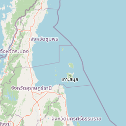
Map view of Si Phang Nga National Park

Use this park location map to pinpoint Si Phang Nga National Park in Thailand, understand its exact geographic position, and read its mapped placement within the surrounding landscape more clearly.

Pigeon | © OpenStreetMap contributors

Location context for Si Phang Nga National Park

Phang Nga Province
Park atlas

Trace the regional spread of protected areas and compare similar limestone karst landscapes across the Andaman Sea coast.

Discover Other National Parks Near Si Phang-nga National Park in Thailand's Coastal Karst Region

Explore other national parks and protected areas geographically near Si Phang-nga National Park, extending your discovery across Thailand's distinctive Andaman Sea coastal region. Compare diverse protected landscapes, including limestone karst formations and expansive mangrove ecosystems, to understand the broader conservation geography of this unique tropical environment.
National parkSurat Thani Province
About 24 km away#1 closest

South

Khao Sok National Park: Protected Landscape Atlas and Geographic Detail

Explore mapped boundaries and regional terrain in Surat Thani Province.

Khao Sok National Park represents a crucial protected landscape within the expansive geography of Surat Thani Province, Thailand. This detailed entry focuses on the park's identity as a national park, emphasizing its mapped boundaries and the surrounding natural terrain. Through structured information and geographic context, users can gain a clear understanding of Khao Sok National Park's place in the atlas, contributing to a more informed approach to landscape discovery.

Area
739 km²
Established
1980
IUCN
II
Visitors
419.5K annual
National parkSurat Thani Province
About 40 km away#2 closest

Southeast

Khlong Phanom National Park: Protected National Park in Surat Thani Province, Southern Thailand

Discover its mapped boundaries and regional landscape context.

Khlong Phanom National Park is a designated national park providing valuable insight into the natural geography of Surat Thani Province. This protected landscape serves as a key entity for understanding regional terrain and the distribution of conservation areas in Southern Thailand. Explore its mapped geographic features and protected boundaries to gain a structured understanding of its place within the national park atlas.

Area
410 km²
Established
2000
IUCN
II
Visitors
1.7K annual
National parkSurat Thani Province
About 47 km away#3 closest

East

Kaeng Krung National Park: Exploring Protected Area Boundaries and Regional Geography

A National Park within Surat Thani Province's diverse landscapes.

Kaeng Krung National Park is a distinct protected area situated in Surat Thani Province, Thailand. This page provides essential context for understanding the park's geographic significance, its mapped boundaries, and its contribution to the regional protected landscape atlas. Explore the fundamental geographic characteristics that define this important natural reserve and its surrounding terrain.

Area
541 km²
Established
1991
IUCN
II
Visitors
909 annual
National parkRanong
About 50 km away#4 closest

North

Laem Son National Park: A Protected National Park in Ranong's Geographic Landscape

Explore the mapped natural terrain and protected area boundaries.

Laem Son National Park is a key protected area within Thailand's Ranong province, offering valuable insights into regional geography and landscape preservation. This entry focuses on its status as a national park, providing a structured view of its protected boundaries and environmental context. Understand its unique position within the mapped geography, vital for any comprehensive atlas exploration of protected lands in the region.

Area
315 km²
Established
1983
IUCN
II
Visitors
21.9K annual
National parkPhang Nga Province
About 54 km away#5 closest

Southwest

Khao Lak, Lam Ru National Park: Protected National Park Landscape and Geography

Explore its mapped boundaries and regional context in Phang Nga Province.

This entry focuses on Khao Lak, Lam Ru National Park, a designated national park offering a distinct protected landscape within Phang Nga Province, Thailand. It provides structured data and map context crucial for understanding its geographic scope and regional significance. Explore the park's mapped boundaries, its role as a protected area, and its contribution to the broader landscape of southern Thailand, fostering a deeper appreciation for its natural geography and atlas-derived insights.

Area
125 km²
Established
1991
IUCN
II
Visitors
72.2K annual
National parkThailand
About 73 km away#6 closest

Northwest

Mu Ko Surin National Park: Mapped Marine Protected Area in Thailand's Andaman Sea

Explore unique island geography and vibrant coral reef landscapes.

Mu Ko Surin National Park is a national park comprising a series of islands within Thailand's Andaman Sea, recognized for its exceptional marine biodiversity and well-preserved coral reefs. This protected area showcases a distinctive landscape where dense tropical forests meet extensive underwater ecosystems, offering a prime example of coastal natural geography. Understanding Mu Ko Surin National Park through its mapped boundaries and ecological significance provides valuable insight into Thailand's protected natural heritage and its role in regional conservation.

IUCN
II
Scope
Marine
National parkThailand
About 82 km away#7 closest

South

Ao Phang Nga National Park: A Protected National Park in Thailand's Geographic Atlas

Explore the mapped landscape and protected area identity.

Ao Phang Nga National Park offers a distinct protected landscape within Thailand, serving as a key entry in the national park atlas. This page focuses on delineating its geographic boundaries and understanding its specific characteristics as a national park. Users can discover the mapped context and regional setting, providing valuable insights into Thailand's protected natural areas and their conservation significance.

Area
400 km²
Established
1981
IUCN
II
Visitors
999K annual
National parkPhang Nga Province
About 84 km away#8 closest

South

Khao Lampi, Hat Thai Mueang National Park: Mountain Rainforest and Andaman Coast Atlas

Explore the mapped geography and protected boundaries.

Delve into Khao Lampi, Hat Thai Mueang National Park, a key protected area within Phang Nga Province, Thailand. This unique national park showcases a striking dichotomy: the lush, waterfall-adorned slopes of the Khao Lampi mountains contrast with the pristine Andaman Sea coastline of Hat Thai Mueang beach, a critical site for sea turtle nesting. The park's mapped landscape encompasses dense tropical rainforest, significant mangrove ecosystems, and important natural terrain, offering a comprehensive view of diverse protected environments for atlas exploration.

Area
72 km²
Established
1986
IUCN
II
Visitors
50.5K annual

Common questions about visiting, size, designation, and location context for Si Phang Nga National Park

Si Phang Nga National Park FAQs for park facts, access, geography, and protected area context

Find quick answers about Si Phang Nga National Park, including protected-area facts, park geography, trail and visitor context, and how the park fits into its surrounding country and regional landscape.
MoriAtlas Explorer

Continue Your Protected Areas Search Across the Global Atlas

Deepen your exploration by continuing the structured search for national parks and protected areas worldwide. Utilize the comprehensive filtering capabilities to compare different conservation landscapes and refine your understanding of global park geography. Discover more about the distribution and characteristics of protected natural areas.

Global natural geography