

Mori Atlas logo
National parkSimien Mountains National Park

Discover the mapped terrain and natural boundaries of this vital national park.

Simien Mountains National Park: Protected Landscape and Geographic Identity in Amhara Region

(Simien National Park)

Simien Mountains National Park represents a significant protected landscape within Ethiopia's Amhara Region, recognized for its unique geography and national park status. This area offers critical insight into the regional terrain and the distribution of protected lands across northern Ethiopia. Users can explore its mapped boundaries and understand its place within a broader geographic atlas context.

UNESCO World Heritage SiteEndemic WildlifeHighland ConservationAfroalpine EcosystemVolcanic MountainsEthiopian Wolf

Simien Mountains National Park

National park

Park overview

Structured park overview, official facts, and landscape profile for Simien Mountains National Park

Simien Mountains National Park park facts, protected area profile, and essential visitor context

Review the core facts for Simien Mountains National Park, including designation, size, terrain, visitor scale, habitats, and operating context in one park-focused overview.

About Simien Mountains National Park

Simien Mountains National Park represents one of Africa's most significant highland protected areas, spanning the upper elevations of the Simien Mountains in northern Ethiopia. The park's location in the Amhara Region places it at the heart of the Ethiopian Highlands, a region of extraordinary geological and ecological importance. The landscape is characterized by dramatic volcanic formations resulting from millions of years of erosion that have carved serrated peaks, profound valleys, and sheer cliffs into the ancient shield volcano remnant. These geological features create some of the most spectacular mountain scenery in the world, with vertical drops of up to 1,500 meters from cliff edges to valley floors. The park's elevation range from around 1,900 meters to over 4,500 meters at Ras Dashen encompasses multiple distinct ecological zones, each supporting characteristic communities of plants and animals adapted to the challenging alpine conditions. The park's biodiversity significance led to its early recognition as a World Heritage Site in 1978, making it one of the first African sites to receive this designation under the natural criteria. Its subsequent placement on the Danger list from 1996 to 2017 reflected concerns about population declines in key endemic species, though successful conservation efforts subsequently enabled its removal from this list.

Quick facts and research context for Simien Mountains National Park

Simien Mountains National Park covers 412 square kilometers in the Amhara Region of northern Ethiopia. The park was established in 1969 and became Ethiopia's first UNESCO World Heritage Site in 1978. It remained on the World Heritage in Danger list from 1996 to 2017 due to population declines of key species. The park features the Simien Massif, a remnant of a large shield volcano formed from Paleogene volcanic flood basalts approximately 30 million years ago. An unpaved road crosses the park from Debarq to Buahit Pass, reaching elevations above 4,400 meters. The park recorded approximately 26,000 visitors in 2016.

Protection and recognition

Documented terrestrial boundaries, designation history, and international conservation status.

Simien Mountains National Park Protection Status and UNESCO World Heritage Designation

Official datasets outline the terrestrial protection status and established boundaries of Simien Mountains National Park, which was first designated in 1978. Geographers and conservation analysts can trace formal management frameworks alongside prestigious international recognition such as the UNESCO World Heritage designation.

International recognition

Protection details

Protection scope
Terrestrial
Designated year
1978
Transboundary protection
No
Park context

Deeper park guide and search-rich context for Simien Mountains National Park

Simien Mountains National Park history, landscape, wildlife, and travel context

Explore Simien Mountains National Park through its history, landscape character, ecosystems, wildlife, conservation priorities, cultural context, and seasonal travel timing in a structured park guide built for atlas discovery and search intent.

Why Simien Mountains National Park stands out

Simien Mountains National Park is best known for its dramatic volcanic highland landscape and exceptional endemic wildlife. The park protects the Walia ibex, a wild goat found nowhere else in the world, and the Ethiopian wolf, one of Africa's rarest canids. The park also hosts substantial populations of gelada baboons, the only surviving member of the genus Theropithecus. Its avifauna includes the bearded vulture with a three-meter wingspan, along with multiple eagle species and the thick-billed raven. The afroalpine vegetation features distinctive giant lobelias and ericaceous heath communities that create a unique high-altitude ecosystem unlike any other in Africa.

Simien Mountains National Park history and protected-area timeline

Simien Mountains National Park was established in 1969 through the efforts of Clive Nicol, a conservationist who played a pivotal role in creating Ethiopia's first national park. Nicol documented his experiences in establishing the park in his book From the Roof of Africa, published in 1971. The Simien region has been inhabited and cultivated for at least 2,000 years, with human activity shaping the landscape long before formal protection was established. The park achieved international recognition in 1978 when it became one of the earliest African sites inscribed on the UNESCO World Heritage List, cited for both its outstanding biodiversity and spectacular natural landscape under criteria vii and x. However, by 1996, the park was added to the List of World Heritage in Danger due to serious population declines in its characteristic native species, particularly the Walia ibex and Ethiopian wolf. This designation reflected concerns about habitat degradation, human encroachment, and the challenges of managing a protected area with resident communities. After two decades of conservation intervention and community engagement, the park was removed from the Danger list in 2017 following stabilization of key species populations, marking a significant conservation success.

Simien Mountains National Park landscape and geographic character

The physical landscape of Simien Mountains National Park is defined by its location within the Simien Massif, a large remnant of an ancient shield volcano formed from volcanic flood basalts dating to the Paleogene period approximately 30 million years ago. Over geological time, extensive erosion of the Ethiopian plateau has carved the massif into a spectacular array of serrated mountain peaks, deep river valleys, and near-vertical cliffs reaching heights of 1,500 meters. The highest point within the park and all of Ethiopia is Ras Dashen, towering above the surrounding terrain. The Mayshasha River traverses the park from north to south, fed by the two rainy seasons that characterize the Ethiopian highlands and creating an essential water resource for both wildlife and local communities. The terrain is characterized by its dramatic relief, with the western side of the Simien Mountains presenting a rugged wilderness of exposed basalt, grass-covered slopes, and isolated peaks that create an almost lunar quality to certain areas. The unpaved road crossing the park from Debarq to Buahit Pass provides access through this dramatic terrain, reaching elevations where the air thins and the vegetation transitions from montane forest through ericaceous heath to sparse afroalpine communities.

Simien Mountains National Park ecosystems, habitats, and plant life

The ecological character of Simien Mountains National Park is defined by a vertically stratified system of habitats that transitions from montane forest through ericaceous belt to afroalpine zones as elevation increases. The montane forest zone, spanning approximately 1,900 to 3,000 meters, contains juniper trees, African redwood (Hagenia abyssinica), African olive, fig species, and waterberry, creating a relatively dense canopy in favorable locations. The ericaceous or subafroalpine belt from 2,700 to 3,700 meters features extensive tree heath (Erica arborea) communities and marks a transition to more open landscapes. Above 3,700 meters, the afroalpine zone extends to the highest peaks, characterized by lower-growing vegetation adapted to the harsh conditions, including the distinctive giant lobelia (Lobelia rhynchopetalum) with its remarkable vertical flowering stalks. The flora also includes yellow primrose, various everlastings (Helichrysum species), lady's mantle (Alchemilla species), and extensive lichen cover on rocks and trees. This vertical zonation creates remarkable ecological diversity within a relatively compact area, with each zone supporting distinct communities of invertebrates, birds, and mammals adapted to those specific conditions.

Simien Mountains National Park wildlife and species highlights

Simien Mountains National Park supports exceptional mammalian biodiversity with 21 large mammal species recorded within its boundaries, including several of the highest conservation priority species in Africa. The Walia ibex represents one of the park's most significant conservation assets, being endemic to the Ethiopian Highlands and found nowhere else on Earth. The Ethiopian wolf, also known as the Simien fox, is among Africa's rarest canids and occurs in significant populations within the park, representing a globally threatened species requiring specialized highland habitat. The gelada baboon, the only surviving member of its genus, inhabits the park in substantial troops, recognizable by their distinctive golden mantle and social behavior on the highland grasslands. Other notable mammals include Menelik's bushbuck, leopard, caracal, serval, spotted hyena, golden jackal, and various primates including the colobus monkey and olive baboon. The bird fauna is equally impressive, with approximately 400 species recorded including the bearded vulture or lammergeier with its impressive three-meter wingspan, multiple eagle species including Tawny eagle, Rüppell's vulture, and Verreaux's eagle, along with thick-billed raven and numerous other avian inhabitants of the highland environment.

Simien Mountains National Park conservation status and protection priorities

Simien Mountains National Park is protected under Ethiopia's National Reserve Act, with management overseen by the Ethiopian Wildlife Conservation Authority. The park's conservation significance is underscored by its UNESCO World Heritage status and its role as a refuge for multiple globally threatened species. Conservation challenges include the need to balance protection objectives with the livelihoods of local communities who have inhabited the region for millennia. Management strategies emphasize working closely with residents to reduce pressure on park resources through sustainable practices and livelihood alternatives. Financial support for effective park management remains critical, as does the need for boundary revision, implementation of comprehensive management plans, and ongoing monitoring of key species populations. Environmental education programs targeting both resident and surrounding communities are essential for building local support for conservation. The successful removal of the park from the World Heritage in Danger list in 2017 demonstrates that targeted conservation interventions can stabilize populations of threatened species when adequately resourced and implemented.

Simien Mountains National Park cultural meaning and human context

The Simien region has been inhabited and cultivated for at least 2,000 years, with human communities maintaining presence in these highland areas long before the establishment of formal protected area status. Local residents have developed traditional land use practices adapted to the challenging mountain environment, though these practices have sometimes created tension with conservation objectives. The park contains villages along the road corridor that passes through its territory, with communities whose ancestors have lived in these landscapes for generations. The resettlement of inhabitants has been a subject of controversy, with critics characterizing certain conservation-driven relocations as a form of green colonialism that replaces local people's traditional practices with eco-tourism economics. This highlights the complex challenge of balancing biodiversity protection with the rights and livelihoods of indigenous and local communities who depend on the landscape. Any sustainable conservation approach must consider these human dimensions and work toward solutions that respect both ecological integrity and community wellbeing.

Top sights and standout views in Simien Mountains National Park

The defining highlights of Simien Mountains National Park combine spectacular volcanic landscape with irreplaceable endemic biodiversity. The massive cliffs and serrated peaks of the Simien Massif create one of Africa's most visually dramatic mountain environments, while the park's elevation range supports ecological communities found nowhere else on the planet. The Walia ibex, found only in these Ethiopian highlands, represents a conservation priority species whose survival depends on protected area management. The Ethiopian wolf populations in the park constitute one of the last viable strongholds for this critically canid. The gelada baboon herds visible on the highland grasslands offer remarkable wildlife viewing opportunities. The bearded vulture gliding on thermal currents above the cliffs provides one of the most iconic avian sights in African protected areas. The giant lobelias and ericaceous vegetation of the afroalpine zone create a botanical landscape unlike anything else in Africa, completing an experience that combines geological wonder, ecological significance, and exceptional wildlife viewing.

Best time to visit Simien Mountains National Park

The optimal time to visit Simien Mountains National Park coincides with the dry season from October through May, when conditions are most favorable for trekking and wildlife viewing. The period from December to February typically offers the clearest skies and most stable weather, though temperatures at higher elevations can drop significantly, especially at night. The main rainy season occurs from June to September, with the short rains typically arriving in March and April, making these months less ideal for park visits due to muddy trails and reduced visibility. The dry season provides the best opportunities for observing wildlife as animals congregate around remaining water sources and the vegetation is less dense. However, the park's high elevation means that even during otherwise warm periods, visitors should be prepared for cold conditions, particularly when crossing passes above 4,000 meters. The shoulder seasons of October to November and March to May may offer a balance between favorable weather and fewer visitors, though conditions can be less predictable.
Monthly climate preview

Analyze long-term temperature ranges and precipitation patterns in the Amhara Region

Simien Mountains National Park Monthly Weather and Average Temperatures

Long-term climatology data from the representative coordinate shows a wet period in July and August contrasting with highly arid conditions from November through February. Comparing the complete twelve-month profile reveals how mean temperatures fluctuate mildly between sixteen and twenty degrees Celsius throughout the year.
Annual mean18 °C
16 °C20 °C
Jan17°
Feb18°
Mar19°
Apr20°
May20°
Jun19°
Jul17°
Aug16°
Sep17°
Oct16°
Nov16°
Dec16°
Warmest month
May

19.9 °C

Coolest month
November

16 °C

Wettest month
August

7.7 mm/day

Driest month
January

0.1 mm/day

Park location guide

Geography guide, regional context, and park location map for Simien Mountains National Park

Simien Mountains National Park park geography, regions, and map view in Ethiopia

Understand where Simien Mountains National Park sits in Ethiopia through a broader geographic reading of the surrounding landscape, nearby location context, and its mapped position within the national park landscape.

How Simien Mountains National Park fits into Ethiopia

Ethiopia is a landlocked federal parliamentary republic located in the Horn of Africa. With a population of approximately 135 million people, it is the 14th-most populous country in the world and the most populous landlocked country. The country is known for its ancient history, diverse ethnic groups, and the capital Addis Ababa, which lies near the East African Rift.

Wider geography shaping Simien Mountains National Park in Ethiopia

Ethiopia is located in the Horn of Africa, bordered by Eritrea to the north, Djibouti to the northeast, Somalia to the east, Kenya to the south, South Sudan to the west, and Sudan to the northwest. The country sits on the African and Somali tectonic plates, with the East African Rift running through it. The terrain includes highlands, valleys, and lowlands.

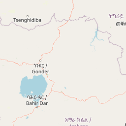
Map view of Simien Mountains National Park

Use this park location map to pinpoint Simien Mountains National Park in Ethiopia, understand its exact geographic position, and read its mapped placement within the surrounding landscape more clearly.

Pigeon | © OpenStreetMap contributors

Location context for Simien Mountains National Park

Amhara Region
Park atlas

Trace the unique protected landscapes and regional park geography surrounding Ethiopia's iconic highlands.

Discover Nearby National Parks and Protected Areas Near Simien Mountains National Park

Beyond Simien Mountains National Park, browse other national parks and protected areas across the Ethiopian highlands and East African geography. This atlas view allows you to compare diverse conservation landscapes, map regional park distributions, and discover additional protected-area entities with similar characteristics.
National parkNorth Gondar Zone
245 km away#1 closest

West

Alitash National Park: Protected Lowland Woodland & Savanna Landscape

Explore the geographic context of this Ethiopian National Park.

Alitash National Park serves as a vital protected area within Ethiopia's North Gondar Zone, encompassing 2,665.7 square kilometers of distinct lowland woodland and savanna ecosystems. The park's landscape is characterized by gently undulating terrain, seasonal river valleys, and the prominent Twin Mountains of Amadog. Its mapped boundaries delineate an area rich in biodiversity, highlighting its significance as a national park for conservation efforts. Understanding Alitash National Park's geographic setting is key to appreciating its role in regional ecological preservation and atlas exploration.

Area
2,665.7 km²
Established
2006
IUCN
II
Relief
Upland
National parkEritrea
About 259 km away#2 closest

North

Semenawi Bahri National Park: Eritrea's Highland Mountainous Protected Area

Explore the dramatic terrain and wildlife of Eritrea's highland national park.

Semenawi Bahri National Park represents a crucial protected landscape in Eritrea, characterized by its striking mountainous terrain. The park's elevation, ranging from 900 to 2400 meters, creates a distinctive highland environment with massive peaks and deep valleys. This unique geography supports a surprising diversity of wildlife, including species adapted to highland conditions, and makes it a compelling destination for exploring Eritrea's natural heritage through its mapped boundaries and regional context.

IUCN
II
Relief
Mountain
Access
Moderate access
Scope
Terrestrial
National parkSudan
About 274 km away#3 closest

West

Dinder National Park: Sudan National Park Exploration and Protected Area Mapping

Mapped landscape context and protected area geography for this Sudanese national park.

This entry details Dinder National Park, a designated national park in Sudan, offering a comprehensive view for geographic exploration. Understand its specific location within Sudan's terrain and its significance as a protected landscape. The information provided is geared towards atlas-based research and understanding the park's mapped boundaries and regional geographic importance, facilitating structured discovery of conservation areas.

Area
10,000 km²
Established
1935
IUCN
II
Relief
Lowland
National parkEritrea
About 314 km away#4 closest

Northeast

Dahlak Marine National Park: Eritrea National Park Mapping and Protected Marine Landscape

Explore its Red Sea geography, coral ecosystems, and marine wildlife.

Delve into Dahlak Marine National Park, a premier protected marine area located off the coast of Eritrea. This national park preserves extensive coral reef formations, critical seabird nesting islands, and important mangrove zones within the Red Sea. It is renowned for supporting over 325 species of fish, providing sanctuary for nesting sea turtles, and being one of the few Red Sea locations where dugongs are found. The park's unique geography and marine biodiversity offer a compelling atlas-style exploration of protected landscapes in the Horn of Africa.

IUCN
II
Relief
Lowland
Access
Highly restricted
Scope
Marine
National parkAfar Region
324 km away#5 closest

Southeast

Yangudi Rassa National Park: Protected Semi-Desert National Park in Afar Region

Mapped landscape and dryland ecosystems.

Yangudi Rassa National Park represents a critical protected area within Ethiopia's Afar Region, covering extensive semi-desert and grassland terrains. The park's geography is marked by Mount Yangudi and the broad Rassa Plains, with the Awash River shaping its riverine forests and marshes. This national park offers a unique insight into dryland ecosystems and their conservation, providing a distinct mapped landscape for geographic study and exploration.

Area
4,731 km²
Established
1969
IUCN
II
Relief
Mixed relief
National parkDjibouti
About 436 km away#6 closest

East

Yoboki National Park: Djibouti National Park Geographic Atlas Explorer

Discover its mapped boundaries and regional terrain.

Yoboki National Park is a key protected area within Djibouti, offering a distinct focus for geographic exploration. This entry provides structured information to understand the park's mapped landscape and its position within the Horn of Africa's regional geography. Delve into the park's protected land identity and terrain context, essential for atlas-based discovery and appreciating its natural features.

IUCN
II
Relief
Mixed relief
Climate
Arid
Scope
Terrestrial
National parkEthiopia
About 475 km away#7 closest

Southeast

Awash National Park: Mapped Protected Boundaries and Ethiopian Regional Geography

Discover the protected landscape of this Ethiopian National Park.

Awash National Park represents a significant protected area within Ethiopia, offering a rich focus for geographic discovery. This page illuminates the park's specific mapped boundaries and its positioning within the surrounding regional geography. It serves as a detailed entry point for understanding the park's landscape character and its role as a national park in East Africa.

Area
850 km²
Established
1966
IUCN
II
Relief
Mixed relief
National parkTadjourah Region
About 482 km away#8 closest

East

Day Forest National Park: Ancient Juniper Woodland and Protected Landscape in Djibouti

Discover a rare East African forest refuge with unique endemic species.

Day Forest National Park represents a critical ecological island within Djibouti's predominantly semi-desert geography. As the nation's oldest national park, it protects the largest remaining East African juniper forest, a vital sanctuary for species found nowhere else on Earth. Located in the Goda Mountains of the Tadjourah Region, its existence relies on rare localized rainfall, creating a distinctive mountainous forest environment that offers profound insights into protected landscape dynamics and regional biodiversity.

Area
15 km²
Established
1939
IUCN
II
Relief
Mountain

Common questions about visiting, size, designation, and location context for Simien Mountains National Park

Simien Mountains National Park FAQs for park facts, access, geography, and protected area context

Find quick answers about Simien Mountains National Park, including protected-area facts, park geography, trail and visitor context, and how the park fits into its surrounding country and regional landscape.
MoriAtlas Explorer

Continue Your Protected Areas Search Across the Global Atlas

Deepen your exploration by continuing the structured search for national parks and protected areas worldwide. Utilize the comprehensive filtering capabilities to compare different conservation landscapes and refine your understanding of global park geography. Discover more about the distribution and characteristics of protected natural areas.

Global natural geography

