
Cave entrances
Park geography
Understanding the territorial extent, mountain terrain, and karst landscape features.
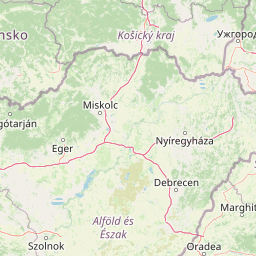
Geographic Profile and Mapped Boundaries of Slovak Karst National Park in the Košice Region
This geographic profile details the physical characteristics of Slovak Karst National Park within the Košice Region of Slovakia. It provides insights into the park boundary spanning over 346 square kilometers, featuring complex mountain karst topography, canyons, and numerous recorded cave entrances located within the protected territory.
Related tags
karst landscapecave systemsUNESCO World Heritage Sitebiosphere reservelimestone formations
Carpathian karst landscape with Europe's most significant cave systems
Slovak Karst National Park
Slovak Karst National Park protects one of Central Europe's most significant karst landscapes in the Slovak Karst mountain range of southeastern Slovakia. The park encompasses approximately 346 square kilometers of rugged terrain characterized by extensive limestone formations, deep canyons, and one of the continent's highest concentrations of caves. Established as a national park in 2002 after decades as a protected landscape area, the region holds exceptional scientific and conservation value as Slovakia's first biosphere reserve designated by UNESCO in 1977. The park's underground world is particularly notable, with nearly 1,300 documented caves representing approximately one-sixth of all known caves in Slovakia, twelve of which form part of a UNESCO World Heritage Site spanning the Slovak and Aggtelek karst regions. The surface landscape features dramatic limestone plateaus, sheer cliffs, and forested slopes that support diverse ecosystems spanning alpine meadows to karst wetlands.
- Location
- Slovakia
- Park type
- National park
- Established
- 2002
- Area
- 346.1 km²
Location overview
Regional Placements within the Košice Region of Slovakia
Geographic Overview of Slovak Karst National Park in Slovakia
Slovak Karst National Park sits inside Slovakia, located entirely within the Košice Region. Administrative data classifies the protected area as a landlocked, non-transboundary territory.
- Countries
- Slovakia
- Regions
- Košice Region
- Primary location
- Košice Region
- Geographic setting
- Inland
Boundary and coordinates
Analyzed geographic dimensions, area measurements, and boundary layout
Slovak Karst National Park Boundary Map and Spatial Extent
Mapped park geometry provides immediate spatial context for the protected territory and surrounding regional terrain. Accompanying boundary facts detail the recorded surface area, coordinate limits, and central geographic spans.
- Boundary area
- 343.5 km²
- Boundary perimeter
- 371.5 km
- Northernmost point
- 48.6932° N
- Southernmost point
- 48.4745° N
- Easternmost point
- 20.9807° E
- Westernmost point
- 20.3477° E
- Geographic centre
- 48.603° N, 20.63° E
- North–south span
- 24.3 km
- East–west span
- 46.7 km
Terrain and natural features
Explore recorded peaks, caves, and springs located across the protected landscape
Slovak Karst National Park Mountain Terrain and Named Natural Features
Stored mountain terrain classifications encompass multiple recorded natural features situated within Slovak Karst National Park. Linked feature cards supply names, types, and spatial relationships for each verified entry.
Selected named natural features
Streams
Turňa
Mountain ranges
Revúcka vrchovina
Cave entrances
Klubová priepasť
Cave entrances
Poľovnícka jaskyňa I
535 m
Sinkholes
Prepadlisko 136
Environmental setting
Analysis of recorded karst, canyon, and mountain relief classifications
Environmental Classifications and Physical Settings of Slovak Karst National Park
Stored landscape features serve as interpretive categories for reading the physical setting of Slovak Karst National Park. Recorded classifications link directly to relevant protected area destinations across the regional atlas.
- Relief
- Mountain
- Water
- Minor water
Landscape features
Karst · Cliffs · Canyon
Park atlas
Map the protected landscapes surrounding Slovak Karst, tracing regional geography and conservation spread.
Compare National Parks Near Slovak Karst, Discover Central European Protected Landscapes
Browse national parks and protected areas geographically adjacent to Slovak Karst National Park, continuing your exploration of similar Central European landscapes. Compare diverse karst formations, mountain ranges, and conservation efforts across the regional context, enhancing your atlas-based understanding of protected terrain.
National parkHungary
Park boundaries overlap#1 closest
South

Aggtelek National Park
Karst Landscape & Cave Systems
Explore the protected area of Aggtelek National Park, a UNESCO World Heritage site known for its extensive karst landscapes and significant cave systems. Understand its geographic setting and protected land status.
- Area
- 198.92 km²
- Established
- 1985
- IUCN
- II
- Relief
- Mixed relief

Natural monumentHungary
About 1.3 km away#2 closest
South
Baradla Cave: Karst Geography and Protected Subterranean Landscapes in Northern Hungary
A mapped overview of the Aggtelek Karst subterranean systems.
Baradla Cave functions as a protected natural monument, offering a comprehensive look at the geological processes within the Aggtelek Karst. The system is defined by its seven-kilometer main passage, giant chambers, and extraordinary variety of stalactite and stalagmite formations, revealing how climate and water have shaped the underground landscape over millennia.
- Established
- 1549
- Relief
- Upland
- Climate
- Temperate
- Access
- Easy access
National parkKošice Region
21 km away#3 closest
North

Slovak Paradise National Park: Protected Area Mapping & Geographic Context in Košice Region
Explore the boundaries and terrain of this national park.
Investigate Slovak Paradise National Park, a designated national park situated within Slovakia's Košice Region. This detailed entry provides essential context for understanding its protected landscape features, mapped geographic distribution, and role within regional atlas exploration. Discover its unique terrain and boundaries to build a comprehensive view of Slovak conservation areas.
- Area
- 197.63 km²
- Established
- 1988
- IUCN
- II
- Relief
- Mountain
National parkBanská Bystrica Region
24 km away#4 closest
Northwest
Muránska planina National Park: Discover Slovakia's Karst Plateau and Protected Natural Landscape
Explore mapped boundaries, caves, and endemic flora in Banská Bystrica Region.
Muránska planina National Park represents a significant protected landscape in central Slovakia's Banská Bystrica Region, defined by its extensive karst topography. This national park encompasses a limestone and dolomite plateau rich with geological wonders, including over 150 caves, sinkholes, and karst springs. The unique contrast between the flat plateau surface and the sharp, rocky ravines showcases a dramatic natural terrain. Explore the park's mapped boundaries and its remarkable biodiversity, highlighted by 35 endemic species and rare Tertiary relict flora like Daphne arbuscula, making it a key destination for atlas-based geographic discovery.
- Area
- 213.18 km²
- Established
- 1997
- IUCN
- II
- Relief
- Mountain
National parkSlovakia
25 km away#5 closest
Northwest
Low Tatras National Park: Slovakia's Vast National Park and Carpathian Protected Landscape
Explore mapped terrain and regional geographic context.
The Low Tatras National Park represents Slovakia's largest protected area, encompassing the entirety of the Low Tatras mountain range. Its landscape is defined by dramatic altitudinal diversity, from alpine summits like Ďumbier to extensive forest zones and significant karst formations with notable cave systems. This page provides detailed geographic context and map-based discovery for the park's protected boundaries and its ecological significance within the Carpathian region.
- Area
- 728 km²
- Established
- 1978
- IUCN
- II
- Relief
- Mountain
National parkBorsod-Abaúj-Zemplén County
35 km away#6 closest
South
Bükk National Park: Hungary's Largest National Park with Karst Terrain
Explore mapped boundaries and unique protected landscapes.
Bükk National Park, a protected national park located in Borsod-Abaúj-Zemplén County, Hungary, is recognized for its immense karst landscape. This park offers a significant focus for atlas exploration, with its extensive cave systems, limestone plateaus, and ancient forests providing a unique geographic context for understanding protected areas. Discover the diverse terrain and geological features that define this expansive Hungarian national park.
- Area
- 431.3 km²
- Established
- 1977
- IUCN
- II
- Relief
- Mixed relief

National parkSlovakia
50 km away#7 closest
Northwest
Tatra National Park: Mapping the Alpine Peaks and Glacial Landscapes of Slovakia
Protected Mountain Terrain in the Carpathian Range
Examine the geographic framework of Tatra National Park, a significant protected area in Slovakia defined by dramatic glacial valleys, over three hundred caves, and high-altitude mountain ecosystems. This authoritative entry provides a detailed look at the park's alpine boundaries, hydrological networks, and role as a transboundary biosphere reserve in the Carpathian Mountains.
- Area
- 738 km²
- Established
- 1949
- IUCN
- II
- Relief
- Mountain
National parkLesser Poland Voivodeship
62 km away#8 closest
Northwest

Tatra National Park: An Atlas Discovery of Poland's Alpine High-Mountain Protected Landscape
Glacial valleys, granite peaks, and mountain biodiversity in Lesser Poland.
Tatra National Park stands as a vital sanctuary for Poland's alpine mountain ecosystems. The protected area features a striking landscape of high-altitude rock formations, glacial cirques holding deep blue lakes, and extensive subterranean cave systems. By studying the park boundaries and vertical zonation, users gain insight into the ecological diversity of the Carpathian arc and the physical geography of the Lesser Poland region.
- Area
- 211.64 km²
- Established
- 1954
- IUCN
- II
- Visitors
- 3.9M annual
MoriAtlas Explorer
Continue Mapping Slovak Karst National Park's Unique Protected Landscape and Geography
Deepen your understanding of Slovak Karst National Park by exploring its specific geographic context and mapped natural features. This detailed view supports a structured approach to discovering protected landscapes, comparing regional park distributions, and appreciating the unique subterranean and surface terrain. Engage with the atlas data to visualize the full extent of this remarkable Slovakian national park and its place within the Košice Region.
Browse next
Global natural geography
Explore related park routes
Explore MoriAtlas Global ParksBrowse All MoriAtlas ParksGlobal Park Map DiscoveryMoriAtlas: Browse All CountriesBrowse All MoriAtlas ContinentsNational Park Environment AtlasGrand Canyon National Park AtlasYellowstone National Park AtlasYosemite National Park Atlas and GeographySerengeti National Park AtlasGalápagos National Park Protected LandscapeBanff National Park Geography and AtlasKruger National Park Atlas EntryUluṟu-Kata Tjuṯa National Park AtlasExplore Uluru-Kata Tjuta National Park GeographyPlitvice Lakes National Park AtlasFiordland National Park Protected LandscapeGreat Smoky Mountains National Park AtlasAfghanistan National Parks and Protected AreasAlbania National Parks and Protected AreasAlgeria National Parks and Protected AreasAmerican Samoa National Parks and Protected AreasAndorra National Parks and Protected AreasAngola National Parks and Protected AreasAntarctica National Parks and Protected AreasAntigua and Barbuda Park List