Mori Atlas logo
National parkSt. Herman's Blue Hole National Park

Understand the mapped boundaries and regional geography of this Belizean national park.

St. Herman's Blue Hole National Park: Protected Landscape and Geographic Context in Cayo District

St. Herman's Blue Hole National Park represents a significant protected area within Belize's Cayo District, offering a unique lens for geographic discovery. This page details the park's identity as a national park, emphasizing its mapped boundaries and the surrounding natural landscape. Explore the foundational geography and protected land context crucial for understanding real-world natural areas through an atlas perspective.

National ParkTropical RainforestCave SystemsBirdwatchingKarst LandscapeJungle Pool

St. Herman's Blue Hole National Park

National park

Park overview

Structured park overview, official facts, and landscape profile for St. Herman's Blue Hole National Park

St. Herman's Blue Hole National Park park facts, protected area profile, and essential visitor context
Review the core facts for St. Herman's Blue Hole National Park, including designation, size, terrain, visitor scale, habitats, and operating context in one park-focused overview.

About St. Herman's Blue Hole National Park

St. Herman's Blue Hole National Park represents a unique category of protected area in Belize, protecting an inland geological formation rather than the coastal or marine environments the country is better known for. The park sits in the heart of the Maya Mountains foothills, in the Cayo District, a region characterized by tropical rainforest, karst limestone formations, and abundant water sources. The blue hole itself is a collapsed sinkhole that reveals crystal-clear water fed by underground rivers, creating a striking natural pool surrounded by dense jungle vegetation. The park contains over 500 acres of protected land with multiple hiking trails that allow visitors to explore the tropical forest, visit the caves, and reach the swimming areas. The management by the Belize Audubon Society ensures systematic conservation of the area's natural resources while providing sustainable ecotourism opportunities. The park serves as an important corridor for wildlife movement between larger protected areas and provides habitat for species ranging from tiny tropical birds to large Neotropical mammals.

Quick facts and research context for St. Herman's Blue Hole National Park

St. Herman's Blue Hole National Park covers approximately 500 acres (2 square kilometers) in the Cayo District of central Belize, near Belmopan. The park features two cave systems, St. Hermans and Crystal, along with natural trails through tropical jungle. The central blue hole is a collapsed cave system forming a cool, clear pool ideal for swimming. The park was established in 1986 and is managed by the Belize Audubon Society. It is home to over 200 bird species including the slaty antwren, piratic flycatcher, and red-legged honeycreeper, as well as larger mammals like ocelots, jaguarundis, and jaguars.

Park context

Deeper park guide and search-rich context for St. Herman's Blue Hole National Park

St. Herman's Blue Hole National Park history, landscape, wildlife, and travel context
Explore St. Herman's Blue Hole National Park through its history, landscape character, ecosystems, wildlife, conservation priorities, cultural context, and seasonal travel timing in a structured park guide built for atlas discovery and search intent.

Why St. Herman's Blue Hole National Park stands out

The park is best known for its namesake blue hole, a natural jungle pool formed from a collapsed cave system that offers swimming opportunities in a pristine tropical setting. The two cave systems, St. Hermans and Crystal, provide significant geological and speleological interest. The park is also renowned for its exceptional bird diversity, with over 200 species recorded, including specialty birds like the tody motmot and northern nightingale-wren. The proximity to the Hummingbird Highway makes it an accessible nature destination for visitors exploring inland Belize.

St. Herman's Blue Hole National Park history and protected-area timeline

The land that comprises St. Herman's Blue Hole National Park was acquired by the Government of Belize during the 1960s and 1970s as part of a broader effort to establish protected areas throughout the country. The park was officially declared a national park on November 23, 1986, establishing its legal protection status and setting the framework for conservation management. Initially, the protected area was simply named Blue Hole National Park, reflecting its most prominent feature. However, this naming created confusion with the more famous Blue Hole National Monument, which protects the iconic offshore marine blue hole in the Belize Barrier Reef. To eliminate this confusion and improve geographic clarity for visitors and researchers, the park was renamed St. Herman's Blue Hole National Park in 2005, adding the saint's name that had traditionally been associated with the local cave system. The Belize Audubon Society has administered the park since its establishment, maintaining the balance between conservation protection and public access.

St. Herman's Blue Hole National Park landscape and geographic character

The landscape of St. Herman's Blue Hole National Park is characterized by tropical karst topography, featuring the limestone formations typical of central Belize. The terrain includes gentle hills and valleys carved by ancient water systems, with the collapsed cave chamber that forms the blue hole serving as the landscape's most dramatic feature. Dense tropical jungle covers the park, with broadleaf evergreen trees forming a canopy that creates the cool, shaded environment the area is known for. The two cave systems, St. Hermans and Crystal, represent significant geological features, with Crystal Cave particularly noted for its formations. The landscape provides a lush, green environment with high humidity and abundant vegetation, contrasting with the more arid savanna landscapes found in other parts of Belize.

St. Herman's Blue Hole National Park ecosystems, habitats, and plant life

The nature of St. Herman's Blue Hole National Park reflects the tropical rainforest ecosystem of central Belize, supporting remarkable biodiversity within its relatively compact area. The park's vegetation consists of tall tropical hardwood trees, epiphytes, lianas, and diverse understory plants that create a complex, layered forest structure. The cave systems add another dimension to the park's ecological character, providing roosting sites for bats and other cave-dwelling organisms. The blue hole and its associated water features support aquatic life and create unique microhabitats within the broader forest matrix. The combination of forest, cave, and water environments makes this park an important island of protected habitat within the broader agricultural landscape of Cayo District.

St. Herman's Blue Hole National Park wildlife and species highlights

St. Herman's Blue Hole National Park is home to an impressive diversity of wildlife, particularly notable for its bird population with over 200 species recorded within the park boundaries. The bird community includes many species characteristic of Central American tropical forests, with the slaty antwren, piratic flycatcher, and red-legged honeycreeper representing some of the more distinctive tropical species found here. Two species are considered local specialty birds: the tody motmot and the northern nightingale-wren, both of which attract birdwatching enthusiasts to the park. The mammal population includes three species of Neotropical cats: the ocelot, jaguarundi, and jaguar, all of which have been recorded in the park. These larger predators indicate a healthy ecosystem with sufficient prey populations to support apex predators.

St. Herman's Blue Hole National Park conservation status and protection priorities

St. Herman's Blue Hole National Park serves an important conservation function within Belize's protected area network by preserving an inland geological formation and the associated tropical forest ecosystem. The park protects habitat for species that require intact forest cover, including the large cats that need extensive territories. Its position along the Hummingbird Highway corridor makes it accessible for environmental education and ecotourism, demonstrating the value of conservation to local communities and visitors. The Belize Audubon Society's management approach combines resource protection with sustainable visitor use, ensuring that the park's ecological values are maintained while providing educational and recreational opportunities. The 2005 renaming to distinguish it from Blue Hole National Monument also reflects the park's unique conservation identity as an inland protected area.

St. Herman's Blue Hole National Park cultural meaning and human context

The area surrounding St. Herman's Blue Hole National Park lies within the historical territory of the Maya people, and the cave systems within the park likely held cultural significance for indigenous communities. The name St. Herman reflects the Catholic missionary influence that followed European contact in this region of Central America. The park's location near Belmopan places it in the administrative heart of Belize, making it accessible for both local and international visitors. The Hummingbird Highway, which passes near the park, is one of Belize's most scenic driving routes and has made the park a popular stop for travelers exploring the country's interior attractions.

Top sights and standout views in St. Herman's Blue Hole National Park

The standout features of St. Herman's Blue Hole National Park include the striking blue hole itself, a collapsed cave chamber filled with clear water perfect for swimming in a jungle setting. The two cave systems offer exploration opportunities, with Crystal Cave being particularly notable for its geological formations. The exceptional bird diversity, with over 200 species including specialty birds like the tody motmot, makes the park a destination for birdwatchers. The well-maintained trail system allows visitors to experience the tropical forest environment, and the park's location near the Hummingbird Highway makes it an easy addition to any inland Belize itinerary.

Best time to visit St. Herman's Blue Hole National Park

The best time to visit St. Herman's Blue Hole National Park is during the dry season, typically from December through April, when visitor access is most convenient and trail conditions are at their best. During this period, the weather is generally sunny with lower humidity, making outdoor exploration more comfortable. The wet season, from May through November, brings heavier rainfall that can make trails muddy and some areas harder to access, though the jungle landscape is at its most lush during these months. Year-round, the park offers a consistent tropical experience, with the blue hole providing a refreshing escape from the warmth regardless of season.

Park location guide

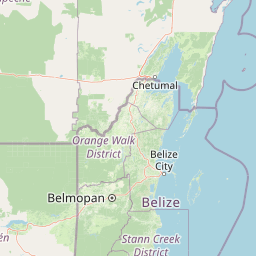
Geography guide, regional context, and park location map for St. Herman's Blue Hole National Park

St. Herman's Blue Hole National Park park geography, regions, and map view in Belize
Understand where St. Herman's Blue Hole National Park sits in Belize through a broader geographic reading of the surrounding landscape, nearby location context, and its mapped position within the national park landscape.

How St. Herman's Blue Hole National Park fits into Belize

Belize is a Caribbean and Central American nation located on the Yucatán Peninsula's eastern coast. It gained independence from Britain in 1981 and remains a Commonwealth realm with Charles III as monarch. The country features diverse cultures, multiple spoken languages including Belizean Creole, Spanish, and Mayan languages, and is recognized for its rich marine biodiversity including the Mesoamerican Barrier Reef.

Wider geography shaping St. Herman's Blue Hole National Park in Belize

Belize occupies the eastern coast of the Yucatán Peninsula, stretching approximately 290 kilometres long and 110 kilometres wide. It is bordered by Mexico to the north and west, Guatemala to the south and west, and the Caribbean Sea to the east. The country also shares a maritime boundary with Honduras. The landscape includes coastal plains, swamps, and the Maya Mountains in the interior.

Map view of St. Herman's Blue Hole National Park

Use this park location map to pinpoint St. Herman's Blue Hole National Park in Belize, understand its exact geographic position, and read its mapped placement within the surrounding landscape more clearly.

Pigeon | © OpenStreetMap contributors

Location context for St. Herman's Blue Hole National Park

Cayo District
Park atlas

Discover other protected areas and national parks in central Belize, comparing diverse karst topography and jungle ecosystems.

Explore More Parks Near St. Herman's Blue Hole National Park, Belize: Regional Protected Areas
Continue your exploration from St. Herman's Blue Hole National Park by browsing other national parks and protected areas across central Belize, focusing on nearby inland jungle and cave systems. Compare varied conservation landscapes, understand regional protected area distribution, and trace the spread of Belize's unique tropical karst environments for deeper geographic context.
National parkCayo District

Guanacaste National Park National Park: Explore its Protected Landscape and Geographic Setting

Mapped natural terrain and regional context within Cayo District.

Delve into the specifics of Guanacaste National Park, a protected national park located in the Cayo District of Belize. This detail page is designed for atlas exploration, offering insights into the park's geographic boundaries and its significance as a defined natural landscape. Understand how this protected area fits into the regional geography and contributes to the mapped natural heritage of Belize.

Area
0.2 km²
Established
1973
IUCN
II
Climate
Tropical
National parkCayo District

Elijio Panti National Park: Protected Landscape and Regional Geography in Cayo District

Explore the mapped boundaries and geographic features of this national park.

Elijio Panti National Park offers a unique focus on protected landscape discovery within Belize. Situated in the Cayo District, this national park provides a specific geographic anchor for understanding natural terrain and mapped boundaries. The page details its identity as a protected area, contributing to a structured atlas of conservation lands and regional geography.

Area
52.645 km²
Established
2001
IUCN
II
Relief
Mountain
National parkCayo District

Chiquibul National Park: Detailed Protected Area and National Park Geography

Explore mapped boundaries within Belize's Cayo District.

Chiquibul National Park offers a critical lens through which to view Belize's protected natural areas. As a designated national park located in the Cayo District, it provides essential data for understanding the extent and geographic positioning of conservation landscapes. Users can engage with detailed map information to trace the park's borders and appreciate its role within the national atlas of protected territories.

Area
1,073 km²
Established
1995
IUCN
II
Relief
Mountain
National parkToledo District

Payne's Creek National Park: National Park Protected Landscape and Geographic Atlas

Explore mapped boundaries and regional geography in Toledo District.

Payne's Creek National Park serves as a vital protected area within Belize, recognized as a national park. This entry details its specific location within the Toledo District, emphasizing the mapped extent of its protected boundaries. It provides a foundation for understanding the park's geographic character and its role within regional conservation landscapes, ideal for atlas-based discovery.

Area
152 km²
IUCN
II
Relief
Lowland
Climate
Tropical
National parkToledo District

Sarstoon-Temash National Park: National Park Geography and Mapped Boundaries

Explore the protected landscape of Toledo District.

Sarstoon-Temash National Park is a key protected area located in Belize's Toledo District. As a national park, it offers distinct geographic features and mapped boundaries that are crucial for understanding regional conservation landscapes. This entry provides detailed context on its protected status and geographic setting, enabling a more profound atlas-based exploration of the natural terrain and its significance.

Area
165.92 km²
Established
1994
IUCN
II
Relief
Lowland
National parkAmbergris Caye

Bacalar Chico National Park and Marine Reserve: Belize National Park & Marine Reserve Atlas

Explore Ambergris Caye's unique barrier island and reef geography.

Discover the extensive protected territory of Bacalar Chico National Park and Marine Reserve, a critical national park and marine reserve situated on Ambergris Caye, Belize. This protected area showcases a rich diversity of landscapes, from rare littoral forests and inland wetlands to vital coral reefs and sea grass beds integral to the Mesoamerican Barrier Reef System. Its unique geographic position and ecological significance make it a key destination for understanding Belize's conservation landscapes and mapped marine environments.

Area
62.8 km²
Established
1996
IUCN
IV
Relief
Lowland
National parkPetén

El Rosario National Park: Protected National Park & Mapped Landscape Explorer

Geographic context and protected area boundaries within Petén.

Delve into the protected landscape of El Rosario National Park, identified as a national park within Guatemala's Petén region. This page provides an atlas-centric view, highlighting its mapped park boundaries and its significance in the regional geography. Understand the park as a distinct protected area contributing to the natural landscape context, ideal for geographic exploration and detailed mapping.

Area
11.05 km²
Established
1980
IUCN
II
Relief
Lowland
National parkHonduras

Cusuco National Park: Protected Landscape and Geographic Atlas in Honduras

Explore mapped boundaries and regional natural terrain.

Cusuco National Park represents a crucial protected area within Honduras, offering rich detail for geographic exploration. This entry focuses on its identity as a national park, detailing its mapped boundaries and its contribution to the broader landscape context of Central America. Users can discover the specific protected lands and natural terrain that characterize this significant conservation site, building a foundational understanding for atlas-based study.

Area
234.4 km²
Established
1959
IUCN
II
Relief
Mountain

Common questions about visiting, size, designation, and location context for St. Herman's Blue Hole National Park

St. Herman's Blue Hole National Park FAQs for park facts, access, geography, and protected area context
Find quick answers about St. Herman's Blue Hole National Park, including protected-area facts, park geography, trail and visitor context, and how the park fits into its surrounding country and regional landscape.
MoriAtlas Explorer

Continue Your Protected Areas Search Across the Global Atlas

Deepen your exploration by continuing the structured search for national parks and protected areas worldwide. Utilize the comprehensive filtering capabilities to compare different conservation landscapes and refine your understanding of global park geography. Discover more about the distribution and characteristics of protected natural areas.

Global natural geography