Mori Atlas logo
Wildlife reserveTabin Wildlife Reserve

A detailed look at the lowland dipterocarp forests and unique mineral mud volcanoes of the Dent Peninsula.

Tabin Wildlife Reserve: Comprehensive Geographic Analysis and Protected Landscape Mapping in Sabah

Tabin Wildlife Reserve stands as a crucial ecological anchor within the eastern lowlands of Sabah. Spanning over 1,225 square kilometers of contiguous jungle on the Dent Peninsula, the reserve provides a protected refuge for large Bornean mammals including elephants and rhinoceros. Its geography is defined by undulating lowland terrain, gallery forests along the Segama River basin, and a series of active natural mud volcanoes that serve as essential mineral licks for wildlife.

wildlife reservelowland dipterocarp forestBornean elephant habitatBornean rhinoceros habitattembadau habitatmudp volcanoes

Tabin Wildlife Reserve

Wildlife reserve

Park overview

Structured park overview, official facts, and landscape profile for Tabin Wildlife Reserve

Tabin Wildlife Reserve park facts, protected area profile, and essential visitor context

Review the core facts for Tabin Wildlife Reserve, including designation, size, terrain, visitor scale, habitats, and operating context in one park-focused overview.

About Tabin Wildlife Reserve

Tabin Wildlife Reserve sits in one of the most wildlife-rich lowland regions of Sabah, the easternmost Malaysian state on the island of Borneo. The reserve occupies the central block of the Dent Peninsula, the narrow finger of land that extends northeastward between the Segama River system to the south and the Silabukan Protection Forest Reserve to the north, and that defines the western shore of Darvel Bay. From the town of Lahad Datu, the nearest major settlement, the reserve is reached by a combination of sealed and gravel roads and generally lies under an hour's drive away.

The reserve's purpose, since its gazetting in 1984, has been explicitly oriented toward the survival of Sabah's vanishing wildlife. Rather than being established primarily around a spectacular landscape feature, Tabin was created with a species-first mandate, reflecting concern about the rapid loss of habitat and populations across Borneo. Most of its approximately 1,225 square kilometers are covered by lowland dipterocarp forest, the tall, multi-layered hardwood canopy typical of Borneo's most biologically productive environments. Within this forest, rivers, seasonal streams, and natural mud volcanoes create a mosaic of microhabitats that support an unusually wide range of mammal and bird species for a single protected area.

In practical terms, Tabin has become one of the anchor destinations of Sabah's nature tourism circuit. Its relative accessibility from Lahad Datu, combined with a network of simple lodges and managed tracks, allows visitors to participate in guided jungle treks, night wildlife-spotting drives, and visits to active mud volcanoes where large mammals regularly appear. The reserve's organizational structure further reinforces its conservation role: the land is state-owned, the Sabah Wildlife Department acts as custodian of its animals, the Sabah Forestry Department oversees its trees, and Sabah Parks manages ecotourism within the reserve. This multi-agency framework, combined with its sheer size, has placed Tabin among the most important wildlife reserves on Borneo.

Quick facts and research context for Tabin Wildlife Reserve

Tabin Wildlife Reserve sits on the Dent Peninsula in Sabah, Malaysian Borneo, roughly 50 kilometers east of Lahad Datu and within reach by a mix of sealed and gravel roads. Created in 1984, it covers approximately 1,225 square kilometers, making it one of the largest contiguous protected lowland forest blocks in northeastern Sabah.

The reserve is classified as IUCN Category IV, a habitat and species management area, and is governed by Sabah Parks. Forest cover is dominated by lowland dipterocarp trees, the characteristic tropical canopy of Borneo, with mud volcanoes and river systems adding key habitat diversity. Its declared purpose is the protection of wildlife rather than landscape scenery alone, particularly the large mammal species for which Sabah is internationally recognized.

Protection and recognition

Documented terrestrial protection scope and verified administrative recognition history

Tabin Wildlife Reserve Protection Status and International Recognition Data

Tabin Wildlife Reserve holds a documented terrestrial protection scope that outlines its formal conservation boundary and administrative framework. Structured recognition records bring together verified management details and international designation statuses for comparative analysis.

Protection details

Protection scope
Terrestrial
Transboundary protection
No
Park context

Deeper park guide and search-rich context for Tabin Wildlife Reserve

Tabin Wildlife Reserve history, landscape, wildlife, and travel context

Explore Tabin Wildlife Reserve through its history, landscape character, ecosystems, wildlife, conservation priorities, cultural context, and seasonal travel timing in a structured park guide built for atlas discovery and search intent.

Why Tabin Wildlife Reserve stands out

Tabin Wildlife Reserve is best known for its role as a refuge for Borneo's rarest large mammals. Its forests safeguard the Bornean elephant, the Bornean rhinoceros, and the tembadau, alongside a broad assemblage of primates, ungulates, and nocturnal carnivores. The presence of all three of these flagship species together in a single reserve is unusual in Southeast Asia and gives Tabin a particular conservation weight. Equally distinctive is the reserve's network of natural mud volcanoes. These mineral-rich seepages draw animals from the surrounding forest, creating predictable wildlife congregations along mineral licks. The combination of extensive lowland dipterocarp cover, large river-influenced habitats, and these focal points of animal activity has shaped Tabin's modern identity as both a conservation stronghold and a destination for small-scale, observation-based ecotourism.
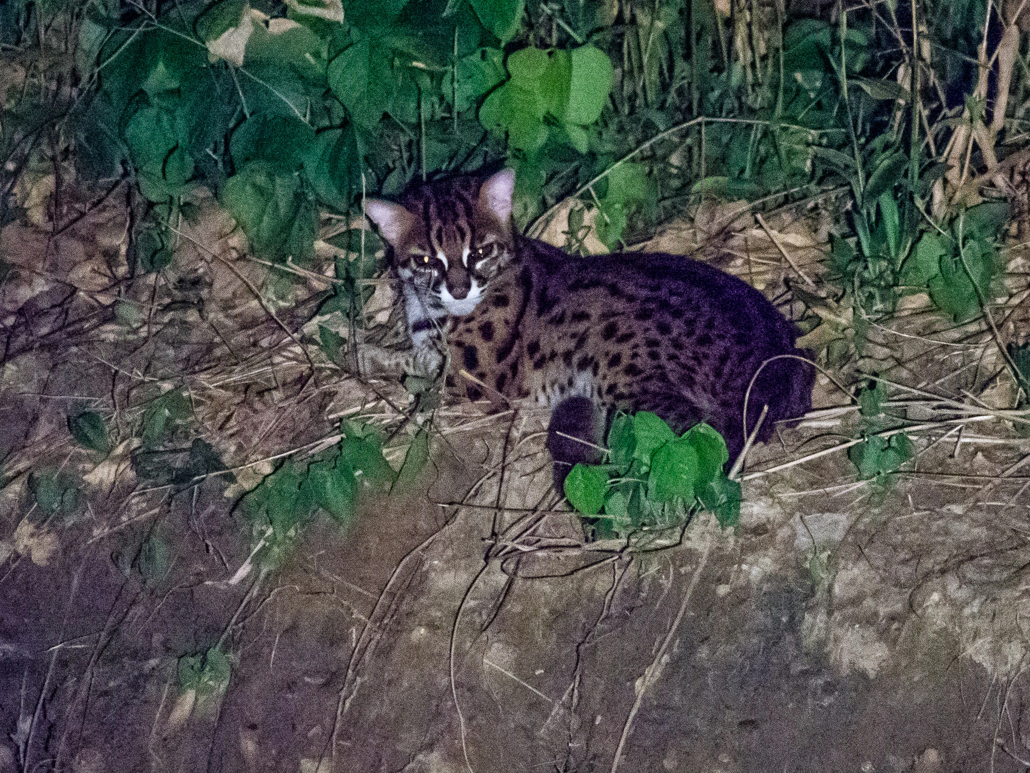
A leopard cat with spotted fur and dark stripes on its head rests on a dirt bank covered in green foliage, captured at night.
A leopard cat photographed at night in the Tabin Wildlife Reserve.

Tabin Wildlife Reserve history and protected-area timeline

Tabin Wildlife Reserve was gazetted in 1984 as a direct response to the accelerating loss of wildlife populations across Sabah. Throughout the latter half of the twentieth century, hunting, logging, and expanding agriculture had pushed several of Borneo's most distinctive mammals toward local extinction outside of protected zones. The new reserve was conceived as a dedicated sanctuary for the species most at risk, including the Bornean elephant, the Bornean rhinoceros, and the tembadau, as well as for the broader community of ungulates, primates, and birds that depend on intact lowland forest.

The reserve was placed under state ownership, with responsibility for its forests assigned to the Sabah Forestry Department and custody of its wildlife given to the Sabah Wildlife Department. In 1998, the Malaysian government moved to privatize ecotourism programming within Tabin, opening the way for increased visitor access. Over the following years, lodges, guided activities, and infrastructure were gradually developed, although the reserve's primary function has remained the protection of its animal populations rather than mass tourism. Surveys in the early 1990s, including an estimate of 120 to 300 elephants within the reserve, helped cement Tabin's reputation as a critical stronghold for Borneo's largest mammals at a time when their numbers everywhere else were sharply declining.

Tabin Wildlife Reserve landscape and geographic character

The physical landscape of Tabin Wildlife Reserve is defined by the eastern lowlands of Sabah and the Dent Peninsula. The terrain is predominantly low-lying, with the reserve forming a broad rectangular block of forested land between the Segama River basin to the south, the Silabukan Protection Forest Reserve to the north, and the coast of Darvel Bay beyond the eastern edge of the peninsula. Elevations are modest and the topography consists largely of undulating lowland rather than dramatic relief.

The dominant vegetation is lowland dipterocarp forest, the typical tropical formation of Borneo, in which tall hardwood trees of the Dipterocarpaceae family create a high closed canopy over a shaded understory. This single forest type extends across most of the reserve, but it is interrupted by several distinctive ground features. Natural mud volcanoes form pools and seepages where mineral-rich soil rises to the surface; these mineral licks attract wildlife and have become focal points for both conservation observation and visitor experience. Riverine corridors along the Segama and its tributaries add another layer of habitat structure, supporting gallery vegetation and feeding into the broader estuarine system of the bay.

The combined effect is a landscape that is visually uniform at the canopy scale, but ecologically varied at ground level, with mud volcanoes, river edges, and forest interior each supporting different animal communities.

Tabin Wildlife Reserve ecosystems, habitats, and plant life

Tabin's ecological importance rests on the combination of a very large block of lowland dipterocarp forest with the hydrological and edaphic features that puncture it. Lowland dipterocarp is the most floristically productive forest type in Borneo, and the sheer size of the reserve allows it to retain internal ecological processes, including movement and seasonal dispersal by large mammals, that smaller fragments cannot support. Rivers, riparian strips, and natural mud seepages contribute additional habitat diversity within an otherwise continuous forest canopy.

Although the protected landscape is sometimes described in simplified terms as dipterocarp forest, the real ecological identity of the reserve is shaped by the interaction between this dominant forest and the mineral-rich mud volcanoes and waterways that draw animals into specific areas. The result is a system where habitat, behavior, and animal distribution are tightly linked. The reserve's forests also act as a climate and watershed buffer for the eastern part of the Dent Peninsula, protecting downstream waters that flow toward Darvel Bay.

Tabin Wildlife Reserve wildlife and species highlights

Tabin Wildlife Reserve was declared primarily for its fauna, and the reserve's animal life remains its defining feature. Three of the largest mammals known from Sabah are present: the Bornean elephant, a forest-dwelling subpopulation of the Asian elephant; the Bornean rhinoceros, a distinctive subspecies of the Sumatran rhinoceros now considered among the rarest large mammals on Earth; and the tembadau, a wild relative of the banteng native to Southeast Asia. The Bornean elephant population within the reserve was estimated at between roughly 120 and 300 animals in the 1990s, an unusually high concentration for a single protected area.

Beyond these flagship species, the reserve supports a full community of ungulates, including sambar deer, various muntjac species, and mouse deer, as well as seven of Sabah's eight primate species. Among the primates are both the orangutan and the proboscis monkey, although populations of these two species within Tabin remain relatively low. Predators include the Sunda clouded leopard, the largest cat in the reserve, along with several smaller carnivores. Birdlife is also significant, ornithological surveys have recorded representatives of 42 families and roughly 220 species. Natural mud volcanoes within the reserve create mineral licks that concentrate wildlife activity, allowing relatively predictable viewing of species that would otherwise be extremely difficult to encounter in dense lowland forest.

Tabin Wildlife Reserve conservation status and protection priorities

From a conservation perspective, Tabin is one of the most important reserves in Sabah because of the symbolic species it harbors. The Bornean rhinoceros, in particular, is now extremely rare across its remaining range, and any reserve that continues to support individuals of this subspecies carries significant weight for the survival of the species. The reserve's population of Bornean elephants similarly represents a substantial proportion of the state's lowland herd, with 1990s estimates placing the local group in the low to mid hundreds.

Beyond individual species, the reserve's value lies in its size and habitat integrity. At roughly 1,225 square kilometers, it is large enough to maintain the ecological processes that large mammals require, including dispersal, seasonal movements, and access to multiple habitat types such as forest interior, river corridors, and mineral licks. This combination of flagship species and forest area has led to conservation-focused management through a multi-agency structure: the Sabah Wildlife Department is responsible for the reserve's animals, the Sabah Forestry Department oversees its forest resources, and Sabah Parks coordinates the reserve's administrative and tourism activities. The IUCN designation as a Category IV habitat and species management area formalizes Tabin's role in maintaining viable populations of particular species within a managed landscape.

Tabin Wildlife Reserve cultural meaning and human context

Tabin's cultural context is modest. The reserve sits on state land managed by Sabah Parks and the relevant wildlife and forestry departments, and there is no prominent built heritage or indigenous community living within the reserve boundaries themselves. The surrounding region of eastern Sabah, however, includes communities whose histories are intertwined with the same lowland forests the reserve protects. Traditional uses of forest products, small-scale hunting, and shifting agriculture have historically shaped the landscape outside the reserve, and the establishment of Tabin in 1984 was itself partly a response to the collapse of these practices under modern pressure.

Top sights and standout views in Tabin Wildlife Reserve

Tabin's highlights cluster around three connected themes. First, the reserve is one of the few places where visitors have a realistic chance of encountering Borneo's three largest mammals within a single protected landscape: the Bornean elephant, the Bornean rhinoceros, and the tembadau. Second, the network of natural mud volcanoes gives concentrated, observable wildlife activity in an otherwise dense forest, an unusually accessible point of contact with animals that normally avoid human presence. Third, the reserve's sheer size and lowland dipterocarp cover give it a coherence that smaller fragments of similar habitat lack, allowing it to function as a true refuge rather than as a narrow ecological refuge strip.

Best time to visit Tabin Wildlife Reserve

Tabin's climate follows the broader pattern of eastern Sabah, with a relatively dry window during the middle of the year and wetter, more humid conditions toward the year-end monsoon. The drier months generally offer easier access along reserve roads and clearer forest conditions for trekking. Wildlife activity around mud volcanoes and water sources remains a strong draw throughout the year, so the differences between seasons are less about whether animals can be seen and more about the comfort and logistics of viewing them. Visitors planning multi-day jungle trekking or night safaris should expect heavier rain and more humid conditions during the wet season months, while the drier periods are typically considered more comfortable for extended time in the forest.

Monthly climate preview

Long-term representative point measurements tracking monthly temperature and precipitation variation

Tabin Wildlife Reserve Climate Normals, Annual Temperature and Precipitation Rhythm

Representative coordinate records show average monthly temperatures remaining steady alongside shifting daily precipitation totals throughout the year. Examining the full twelve-month profile provides complete historical averages for detailed temperature and rainfall comparisons.
Annual mean27 °C
26 °C27 °C
Jan26°
Feb26°
Mar26°
Apr27°
May27°
Jun27°
Jul27°
Aug27°
Sep27°
Oct27°
Nov27°
Dec26°
Warmest month
May

27.4 °C

Coolest month
January

25.9 °C

Wettest month
January

7.9 mm/day

Driest month
April

3.8 mm/day

Park location guide

Geography guide, regional context, and park location map for Tabin Wildlife Reserve

Tabin Wildlife Reserve park geography, regions, and map view in Malaysia

Understand where Tabin Wildlife Reserve sits in Malaysia through a broader geographic reading of the surrounding landscape, nearby location context, and its mapped position within the national park landscape.

How Tabin Wildlife Reserve fits into Malaysia

Malaysia is a federal constitutional monarchy located in Southeast Asia. The country consists of 13 states and three federal territories, divided by the South China Sea into Peninsular Malaysia on the Indochinese Peninsula and East Malaysia on the island of Borneo. With a population of over 34 million, it achieved independence from Britain in 1957 and became a modern federation in 1963. The country is recognized for its multicultural population, tropical climate, and significant economic role in the region.

Wider geography shaping Tabin Wildlife Reserve in Malaysia

Malaysia occupies a strategic position in Southeast Asia, split by the South China Sea into two distinct regions. Peninsular Malaysia lies on the Indochinese Peninsula, sharing a land border with Thailand to the north and maritime borders with Singapore, Vietnam, and Indonesia. East Malaysia occupies the northern portion of Borneo, sharing land borders with Brunei and Indonesia, and maritime borders with the Philippines and Vietnam. The country's terrain includes coastal plains, mountain ranges such as the Titiwangsa in the peninsula, and extensive tropical rainforests.

Map view of Tabin Wildlife Reserve

Use this park location map to pinpoint Tabin Wildlife Reserve in Malaysia, understand its exact geographic position, and read its mapped placement within the surrounding landscape more clearly.

Pigeon | © OpenStreetMap contributors

Location context for Tabin Wildlife Reserve

Sabah

Visual exploration of lowland dipterocarp forests, mineral mud volcanoes, and dense Bornean habitats

Tabin Wildlife Reserve Photos, Scenery, and Protected Landscape Views

Visual records capture the dense lowland dipterocarp canopy, riverine corridors, and natural mineral mud volcanoes defining the protected terrain. Examining these detailed landscape photographs provides a clearer understanding of the ecological character and wildlife habitats preserved across the reserve.

A leopard cat with spotted fur and dark stripes on its head rests on a dirt bank covered in green foliage, captured at night.

Park atlas

Compare regional lowland habitats and connected wildlife reserves across Sabah

Exploring Parks Near Tabin Wildlife Reserve and Surrounding Protected Landscapes

Browse other parks near Tabin Wildlife Reserve to examine broader protected landscapes across the eastern lowlands of Sabah. Continuing into adjacent forest reserves and wildlife sanctuaries provides deeper context on regional biodiversity corridors and lowland dipterocarp habitats.
National parkSabah
About 74 km away#1 closest

South

Tun Sakaran Marine Park National Park: Sabah Marine Archipelago Atlas

Explore the islands, sand cays, and coral reef geography.

Tun Sakaran Marine Park is a protected national park in Sabah, Malaysia, known for its stunning marine biodiversity and archipelago landscape. This atlas entry details the park's distinct islands, dynamic sand cays, and extensive coral reef systems within the Celebes Sea, offering insights into its unique geographic setting and ecological significance.

Area
101 km²
Established
2004
IUCN
II
Relief
Lowland
Wildlife reserveTawi-Tawi
About 98 km away#2 closest

Northwest

Turtle Islands Wildlife Sanctuary: Mapping the Protected Archipelago of Tawi-Tawi

Coastal landscapes, marine habitats, and island terrain

Spanning six islands at the maritime boundary of the Philippines and Malaysia, Turtle Islands Wildlife Sanctuary is defined by its extensive nesting beaches and remnant forest. This protected area integrates marine and coastal habitats, ranging from the volcanic activity on Lihiman to the forested shores of Baguan, offering a unique look at the maritime geography of the Tawi-Tawi region.

Area
2,429.67 km²
Established
1999
A soft watercolor painting of a winding river flowing through a lush, misty green forest under pale hills.
Wildlife reserveSabah
About 116 km away#3 closest

West

Danum Valley Conservation Area: Protected Lowland Rainforest Geography in Sabah

Examining the boundaries and terrain of this Bornean wildlife reserve

Danum Valley Conservation Area serves as a primary site for understanding undisturbed lowland dipterocarp forest in Borneo. This wildlife reserve features a complex bowl shaped basin of rivers, ridges, and dense tropical canopy. Access geographic maps and site data to understand the structural integrity of this protected region located within the state of Sabah.

Area
438 km²
Established
1980
IUCN
Ia
Relief
Highland
National parkMalaysia
About 118 km away#4 closest

Northwest

Turtle Islands National Park: Marine Protected Area and Island Geography in Malaysia

Coastal landscapes and coral reef protected zones

Explore the geographic footprint of Turtle Islands National Park, a marine-focused sanctuary in Malaysia. This protected area encompasses three islands and surrounding Sulu Sea reef ecosystems, providing critical nesting habitat for marine turtles. Learn about the island-based terrain and the marine boundaries that define this protected landscape.

Area
17.4 km²
Established
1977
Relief
Lowland
Climate
Tropical
National parkSabah
About 118 km away#5 closest

Northwest

Turtle Islands National Park: Marine Geography and Protected Island Landscapes in Sabah

A Sulu Sea sanctuary for coral reefs and sea turtle nesting grounds.

Located north of Sandakan, Turtle Islands National Park is a key marine protected area defined by its island geography and extensive coral reef habitat. The park protects critical nesting beaches for green and hawksbill sea turtles, offering a focused look at how marine conservation intersects with tropical island terrain in the Sulu Sea. This geographic profile details the park's offshore environment and its connection to broader maritime conservation efforts in the region.

Area
17.4 km²
Established
1977
IUCN
II
Relief
Lowland
National parkSabah
About 127 km away#6 closest

Southwest

Tawau Hills National Park: Mapped Boundaries and Protected Landscape Identity in Sabah

Explore the geographic scope and regional context of Tawau Hills National Park.

Gain a structured understanding of Tawau Hills National Park as a protected area within the geography of Sabah, Malaysia. This resource details its significance as a national park, highlighting its mapped landscape and its contribution to the regional geographic context. Ideal for users interested in atlas exploration and comprehending the distribution of protected lands.

Area
280 km²
Established
1979
IUCN
II
Relief
Mountain
Watercolor painting of a lake surrounded by green trees and distant pastel-colored hills.
Marine protected areaSabah
About 127 km away#7 closest

South

Sipadan Island Park: Marine Protected Area and Volcanic Seamount Landscape in Sabah, Malaysia

Exploration of submerged coral terrain, reef boundaries, and marine geography.

Sipadan Island Park encompasses 16,860 hectares of protected marine waters, centered on a singular volcanic seamount. This record details the park's underwater landscape, from shallow coral-fringed plateaus to deep-sea drop-offs, providing a clear geographic view of this essential Malaysian marine sanctuary.

Area
168.6 km²
Established
1933
Relief
Lowland
Climate
Tropical
Nature reserveSabah
About 200 km away#8 closest

West

Maliau Basin Nature Reserve: Geographic Overview and Protected Landscape Mapping

Sandstone escarpments and river drainage in Sabah, Malaysia

Explore the structural geography of Maliau Basin, a prominent nature reserve in Sabah. This protected area is defined by its massive sandstone depression, multi-tiered waterfalls, and expansive primary forest coverage. Examine the watershed dynamics of the Maliau River and the mountainous terrain that isolates this significant wilderness from surrounding lowland regions.

Area
588 km²
Established
1981
IUCN
Ia
Water
Major water bodies

Common questions about visiting, size, designation, and location context for Tabin Wildlife Reserve

Tabin Wildlife Reserve FAQs for park facts, access, geography, and protected area context

Find quick answers about Tabin Wildlife Reserve, including protected-area facts, park geography, trail and visitor context, and how the park fits into its surrounding country and regional landscape.
MoriAtlas Explorer

Continue Your Protected Areas Search Across the Global Atlas

Deepen your exploration by continuing the structured search for national parks and protected areas worldwide. Utilize the comprehensive filtering capabilities to compare different conservation landscapes and refine your understanding of global park geography. Discover more about the distribution and characteristics of protected natural areas.

Global natural geography