

Mori Atlas logo
National parkTakatu National Park

Discover the mapped boundaries and unique mountain geography of this vital national park.

Takatu National Park: Pakistan's Highland Protected Landscape in Balochistan

Takatu National Park, a significant addition to Pakistan's protected areas in Balochistan, offers a unique window into high-altitude mountain ecosystems. This national park, centered around the prominent peak of Koh-i-Takatu, encompasses rugged terrain vital for regional biodiversity. Its declaration in early 2025 underscores a commitment to conserving landscapes like those found in the Quetta and Pishin Districts, providing essential habitat for species such as the endangered Sulaiman markhor.

mountain parksBalochistanSulaiman markhornewly establishedwildlife conservationendangered species

Takatu National Park

National park

Park overview

Structured park overview, official facts, and landscape profile for Takatu National Park

Takatu National Park park facts, protected area profile, and essential visitor context

Review the core facts for Takatu National Park, including designation, size, terrain, visitor scale, habitats, and operating context in one park-focused overview.

About Takatu National Park

Takatu National Park occupies a mountainous landscape in the southwestern highlands of Balochistan, Pakistan, where the terrain rises sharply from the surrounding plains to form the distinctive peak of Koh-i-Takatu. This peak, as the third highest in Balochistan, anchors the park's geography and provides the ecological backbone for the protected area. The park spans administrative boundaries across Quetta District and Pishin District, reflecting the extensive nature of the mountain habitats it seeks to protect. Established through formal declaration in January 2025, the park falls under the management jurisdiction of the Balochistan Wildlife Department, which administers protected areas across Pakistan's largest province. The regional setting places Takatu within a broader network of protected areas, with Hazarganji-Chiltan National Park positioned nearby to the southwest, creating an ecological cluster that helps preserve the biodiversity characteristic of Balochistan's mountain environments. The park's creation represents a recognition of the ecological significance of these mountainous landscapes and the need to formally protect the habitats that support endangered species populations.

Quick facts and research context for Takatu National Park

Takatu National Park covers approximately 13,525 hectares in the highlands of western Pakistan, managed by the Balochistan Wildlife Department. The park is classified under IUCN Category II as a national park. Its defining geographic feature is Koh-i-Takatu, the third tallest peak in Balochistan, rising prominently above the surrounding terrain. The park is situated in Quetta and Pishin Districts, in proximity to the cities of Quetta and Pishin. Established in 2025, it represents a recent addition to Pakistan's network of protected areas, designed to conserve the unique mountain ecosystems and biodiversity of Balochistan.

Protection and recognition

Verifying terrestrial boundaries, management scope, and official atlas records.

Takatu National Park Official Protection Status and Protected Area Designation

Exploring the documented terrestrial protection status of Takatu National Park provides essential geographic context on its official conservation standing. Accessing verified designation records helps researchers and conservationists trace the formal management scope of terrestrial protected areas.

Protection details

Protection scope
Terrestrial
Transboundary protection
No
Park context

Deeper park guide and search-rich context for Takatu National Park

Takatu National Park history, landscape, wildlife, and travel context

Explore Takatu National Park through its history, landscape character, ecosystems, wildlife, conservation priorities, cultural context, and seasonal travel timing in a structured park guide built for atlas discovery and search intent.

Why Takatu National Park stands out

Takatu National Park is best known for its population of Sulaiman markhor, an endangered mountain goat-antelope species endemic to the region. The park's dramatic mountain landscape, defined by Koh-i-Takatu and surrounding ridgelines, provides crucial habitat for this flagship species and other wildlife. The park's close proximity to Chiltan Park creates an interconnected protected area network that preserves the distinctive semi-arid mountain ecosystems found in this part of Balochistan. The combination of significant elevation, endemic biodiversity, and recent formal protection makes Takatu notable in Pakistan's conservation landscape.

Takatu National Park history and protected-area timeline

Takatu National Park was officially declared as a national park on 13 January 2025, representing a recent expansion of Pakistan's protected area network. The establishment of the park reflects growing recognition of Balochistan's mountain ecosystems and their importance for biodiversity conservation. Prior to national park status, the area likely existed as a wildlife protected zone or game reserve under the administration of the Balochistan Wildlife Department. The formal designation as a Category II protected area under IUCN classification provides international recognition of the site's conservation significance and establishes a framework for ongoing management and protection. The park's creation contributes to Pakistan's commitments under national biodiversity strategies and international conservation frameworks.

Takatu National Park landscape and geographic character

The landscape of Takatu National Park is dominated by mountainous terrain centered on Koh-i-Takatu, a prominent peak that rises dramatically above the surrounding terrain. The park encompasses steep ridgelines, rocky outcrops, and mountain slopes characteristic of the Balochistan highlands. The elevation change from valley floors to mountain peaks creates diverse microhabitats across the protected area. The region's geology features the rugged, erosional landforms typical of the mountain ranges that traverse western Pakistan and into Afghanistan. Scattered vegetation grows along slopes and in protected pockets, with the overall landscape presenting a semi-arid mountain character distinct from the lowland deserts that surround the higher terrain in this part of Balochistan.

Takatu National Park ecosystems, habitats, and plant life

The ecological character of Takatu National Park reflects the mountain environments of central Balochistan, where semi-arid conditions support distinctive plant and animal communities. The park exists in a transitional zone where desert and mountain ecosystems meet, creating conditions for specialized species adapted to rocky terrain and variable water availability. Vegetation across the park includes drought-resistant shrubs and grasses adapted to the region's climate. The park's biodiversity shows strong connections to nearby Hazarganji-Chiltan National Park, with similar species assemblages reflecting the shared ecological conditions of this geographic region. The mountain habitats provide critical ecological functions, including watershed protection and soil conservation on the steep slopes.

Takatu National Park wildlife and species highlights

Takatu National Park protects important habitat for the Sulaiman markhor, an endangered mountain ungular species that represents the park's most significant wildlife value. Beyond this flagship species, the park supports a diverse mammalian community including the Indian wolf, Asiatic jackal, red fox, caracal, jungle cat, and striped hyena. Smaller mammals present include various hedgehog species, shrews, and rodents such as the Baluchi mouse-like hamster. The avifauna is particularly diverse, with numerous raptor species including golden eagle, tawny eagle, Bonelli's eagle, bearded vulture, and various falcon species. Game birds such as see-see partridge and chukar partridge inhabit the terrain, while the houbara bustard represents a notable migratory species. The combination of mountain habitat and proximity to other protected areas supports wildlife populations that depend on these interconnected habitats for survival.

Takatu National Park conservation status and protection priorities

The designation of Takatu National Park as a Category II protected area under the IUCN framework establishes formal conservation status for a significant mountain ecosystem in Balochistan. The primary conservation focus centers on protecting habitat for the Sulaiman markhor, whose population in the Sulaiman Mountains represents a distinct and regionally endemic species requiring active protection. The park's connection to nearby Chiltan Park creates a conservation network that supports broader ecological processes across the mountain habitats of this region. The formal protection provides a legal framework for managing human activities within the park boundaries and for implementing conservation programs. The park contributes to Pakistan's national protected area coverage and supports international biodiversity conservation targets.

Takatu National Park cultural meaning and human context

Takatu National Park is situated within the traditional lands of Balochistan, a province with deep cultural heritage and historical significance in southwestern Asia. The mountain regions have been inhabited by local communities for generations, with traditional pastoral activities and land use shaping the landscape over centuries. The Balochi people, the predominant ethnic group in the region, maintain cultural connections to the mountainous terrain. The park lies in proximity to Quetta, the provincial capital, and Pishin District, areas with established settlements and historical trade route connections. While the park itself does not contain designated cultural heritage sites, the broader Balochistan landscape holds archaeological and historical significance related to ancient trade routes connecting South Asia with Persia and Central Asia.

Top sights and standout views in Takatu National Park

Takatu National Park's defining highlights include the spectacular peak of Koh-i-Takatu rising as the third highest mountain in Balochistan, providing dramatic backdrop and hiking potential. The park protects critical habitat for the endangered Sulaiman markhor, offering opportunities for wildlife observation of this distinctive mountain goat. The new park designation in 2025 represents Pakistan's commitment to expanding conservation coverage in under-protected regions. The park's proximity to Chiltan Park creates a connected protected area experience for visitors exploring Balochistan's mountain parks. The diverse raptor population including bearded vulture, golden eagle, and Bonelli's eagle makes the park significant for birdwatching enthusiasts. The mountain landscape offers scenic beauty distinct from Pakistan's more famous high-altitude northern parks.

Best time to visit Takatu National Park

Takatu National Park is best visited during the cooler months of spring and autumn when temperatures in the Balochistan highlands are moderate and conducive to outdoor exploration. Summer months can bring hot conditions in the valleys and plains, while winter may bring snow at higher elevations. The shoulder seasons provide comfortable conditions for wildlife viewing and landscape appreciation. Visitors should note that as a newly established park, visitor facilities and access information may be limited and should be confirmed through local authorities before planning trips.

Monthly climate preview

Analyze historical temperature ranges and monthly precipitation patterns across the Balochistan highlands

Takatu National Park Climate and Long-Term Weather by Month

Long-term data at 1813 meters elevation shows significant temperature fluctuations throughout the year, combining sub-freezing winter minimums with dry summer peaks. Accessing the complete monthly profile provides verified historical averages for daily temperatures, maximums, and precipitation levels across the calendar.
Annual mean16 °C
3 °C27 °C
Jan
Feb
Mar10°
Apr16°
May22°
Jun26°
Jul27°
Aug26°
Sep22°
Oct16°
Nov10°
Dec
Warmest month
July

27.3 °C

Coolest month
January

3.5 °C

Wettest month
February

1.1 mm/day

Driest month
May

0.2 mm/day

Park location guide

Geography guide, regional context, and park location map for Takatu National Park

Takatu National Park park geography, regions, and map view in Pakistan

Understand where Takatu National Park sits in Pakistan through a broader geographic reading of the surrounding landscape, nearby location context, and its mapped position within the national park landscape.

How Takatu National Park fits into Pakistan

Pakistan, officially the Islamic Republic of Pakistan, is a federal parliamentary Islamic republic in South Asia. It is the fifth-most populous country and the 33rd-largest by area. The country gained independence from British India in 1947 and has a diverse history spanning ancient civilizations including Mehrgarh and the Indus Valley Civilisation. Pakistan shares maritime borders with Oman and is bounded by the Arabian Sea, Gulf of Oman, and several neighboring countries.

Wider geography shaping Takatu National Park in Pakistan

Pakistan is located in South Asia, bordered by the Arabian Sea to the south, the Gulf of Oman to the southwest, and shares land borders with India to the east, Afghanistan to the west, Iran to the southwest, and China to the northeast. The country also shares a maritime border with Oman in the Gulf of Oman. The Wakhan Corridor in Afghanistan separates Pakistan from Tajikistan in the northwest.

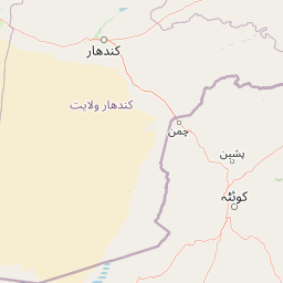
Map view of Takatu National Park

Use this park location map to pinpoint Takatu National Park in Pakistan, understand its exact geographic position, and read its mapped placement within the surrounding landscape more clearly.

Pigeon | © OpenStreetMap contributors

Location context for Takatu National Park

BalochistanPishin DistrictQuetta District
Park atlas

Map the connected protected landscapes and conservation corridors across the Balochistan highlands

Discover Other National Parks and Protected Areas Near Takatu National Park

Explore additional national parks and protected areas situated within the rugged Balochistan highlands, extending your discovery beyond Takatu National Park. This enables direct geographic comparison of diverse mountain terrain, regional conservation efforts, and interconnected protected landscapes across the wider ecological network.
National parkBalochistan
About 32 km away#1 closest

Southwest

Hazarganji-Chiltan National Park: Balochistan's Mountain Protected Area & Landscape

Explore protected wildlife habitats and unique terrain in the Sulaiman Mountains.

Hazarganji-Chiltan National Park represents a significant protected landscape within Balochistan, Pakistan. Designated as a national park, it is fundamental to the conservation of the Chiltan ibex and Sulaiman Markhor, showcasing a unique arid mountain ecosystem. The park's terrain encompasses a transition from desert conditions to higher juniper forests, offering a detailed case study in regional geography and protected area management. Understanding Hazarganji-Chiltan National Park provides essential context for the mapped distribution of critical wildlife habitats in the Sulaiman Mountains range.

Area
155.55 km²
Established
1980
IUCN
II
Relief
Mountain
Biosphere reserveBalochistan
About 108 km away#2 closest

East

Ziarat Juniper Forest Biosphere Reserve: Protected Mountain Landscapes of Balochistan

Ancient juniper woodlands and high mountain terrain in Pakistan.

Ziarat Juniper Forest represents one of the largest and most ecologically significant juniper woodlands in the world. Located in the Ziarat district of Balochistan, this biosphere reserve spans an extensive area of mountainous ridges and deep valleys. The forest is characterized by extreme longevity among its trees and provides a critical case study in dry temperate forest geography, conservation status, and climate tolerance within the broader context of Pakistani mountain landscapes.

Area
1,118.52 km²
Established
2013
IUCN
IV
Relief
Mountain
National parkPakistan
About 108 km away#3 closest

East

Ziarat National Park: Pakistan's Mapped National Park Landscape for Geographic Exploration

Explore protected terrain and regional geography in Pakistan.

Dive into the atlas-based discovery of Ziarat National Park, a significant protected area within Pakistan. This page details its unique geographic characteristics and its placement as a national park, offering a focused view on its mapped landscape. Understand the environmental context and protected land significance of Ziarat National Park for detailed geographic study and map exploration.

Scope
Terrestrial
Water
Minor water
Forest
Mostly forested
Protected areaAfghanistan
About 252 km away#4 closest

North

Ab-i Istada Protected Area: Mapped Wetland Landscape in Afghanistan's Hindu Kush

Explore its unique alkaline geography and bird habitat.

Ab-i Istada is a crucial protected area featuring a large, shallow endorheic salt lake set within a geological depression in Afghanistan's Hindu Kush foothills. This protected landscape is globally recognized for its importance as a stopover for migratory birds. The site's dynamic water levels, alkaline conditions, and surrounding wetlands offer a unique focus for atlas-based geographic exploration and understanding the context of protected areas in Central Asia.

Area
130 km²
Established
1974
IUCN
IV
Relief
Highland
Protected areaIran
About 302 km away#5 closest

East

Koh-e-Sulaiman Protected Area: Sacred Mountain Geography and Landscape Context in Iran

Discover unique terrain and cultural heritage within this protected mountain range.

Koh-e-Sulaiman is a vital protected area within Iran, distinguished by the sacred Takht-e-Sulaiman peak, a site of deep spiritual importance. This landscape features rugged mountains, steep ridges, and deep valleys, contrasting sharply with surrounding plains. The protected area's unique geological complexity and dramatic terrain make it a significant natural and cultural landmark. MoriAtlas offers detailed geographic context to understand its protected boundaries and its role in the regional atlas, focusing on landscape discovery and natural features.

Area
6,475 km²
Relief
Mountain
Climate
Arid
Access
Remote access
Wildlife reserveSindh
About 320 km away#6 closest

South

Drigh Lake Wildlife Reserve: Protected Wetland Geography in Sindh, Pakistan

Mapped freshwater habitat in the Indus river basin

Drigh Lake is a designated wildlife sanctuary and Ramsar site in the Qambar Shahdadkot District of Sindh. This protected area features shallow, reed-fringed freshwater environments that serve as an essential waterbird haven. Analyze the park boundaries and the surrounding alluvial plains that characterize this significant regional wetland geography.

Area
1.64 km²
Established
1972
Scope
Terrestrial
Water
Water-dominated
Wildlife reserveKhairpur District
About 341 km away#7 closest

Southeast

Mehrano Wildlife Sanctuary: Protected Forest Landscapes and Geography in Khairpur District

A historic wildlife reserve along the Indus riverine corridor.

Mehrano Wildlife Sanctuary represents a unique intersection of private historical stewardship and modern conservation. This riverine forest in Khairpur District provides a critical habitat for large game and migratory bird populations, functioning as a lush ecological refuge at the edge of the Cholistan desert. The terrain offers a distinct study in Indus floodplain geography and long-standing protected land management.

Area
2.8 km²
Established
1790
Relief
Lowland
Scope
Terrestrial
Nature reserveBamyan Province
About 405 km away#8 closest

North

Ajar Valley Nature Reserve: Protected Area and Alpine Landscape Identity

Rugged terrain and ibex habitat within Bamyan Province geography.

Ajar Valley Nature Reserve is a cornerstone protected area in Bamyan Province, Afghanistan, recognized for its rugged alpine terrain and role as ibex habitat. Established as one of the nation's oldest nature reserves, it offers a profound insight into the geographic context of the Hindu Kush. This page details the reserve's landscape characteristics, protected boundaries, and its vital place in the country's conservation atlas, providing a factual basis for understanding its ecological significance.

IUCN
IV
Relief
Mountain
Access
Highly restricted
Scope
Terrestrial

Common questions about visiting, size, designation, and location context for Takatu National Park

Takatu National Park FAQs for park facts, access, geography, and protected area context

Find quick answers about Takatu National Park, including protected-area facts, park geography, trail and visitor context, and how the park fits into its surrounding country and regional landscape.
MoriAtlas Explorer

Continue Your Protected Areas Search Across the Global Atlas

Deepen your exploration by continuing the structured search for national parks and protected areas worldwide. Utilize the comprehensive filtering capabilities to compare different conservation landscapes and refine your understanding of global park geography. Discover more about the distribution and characteristics of protected natural areas.

Global natural geography
