

Mori Atlas logo
Protected areaTanda Dam

A Ramsar-designated reservoir providing critical wetland habitat and regional water resources

Tanda Dam: Mapping the Protected Wetland Landscapes and Irrigation Geography of Kohat District

Tanda Dam serves as a pivotal irrigation reservoir and protected wetland site within the Kohat District of Khyber Pakhtunkhwa. Recognized under international conservation treaties, this reservoir balances engineered water management with essential habitat for migratory waterbirds. The surrounding landscape features low hills and agricultural plains, showcasing the intersection of hydrological infrastructure and seasonal ecological importance.

wetlandRamsar siteirrigation reservoirmigratory birdswaterbird habitatKhyber Pakhtunkhwa

Tanda Dam

Protected area

Park overview

Structured park overview, official facts, and landscape profile for Tanda Dam

Tanda Dam park facts, protected area profile, and essential visitor context

Review the core facts for Tanda Dam, including designation, size, terrain, visitor scale, habitats, and operating context in one park-focused overview.

About Tanda Dam

Tanda Dam, also referred to as Tanda Lake, is a modest yet regionally significant reservoir that defines a stretch of the Kohat District landscape in Khyber Pakhtunkhwa. While its original purpose was irrigation, supplying water through a canal network to a chain of nearby villages, the lake has grown in importance as a managed wetland and a place of public engagement with nature in the area.

The reservoir lies within the broader terrain of Kohat, where seasonal streams and low hills shape how water is collected, stored, and distributed. By holding water and releasing it steadily through canals, Tanda Dam supports agriculture in communities such as Jerma, Tappi, Baqizai, Dhoda, and Shahpur, helping to underpin local livelihoods and food production. The reservoir's continued role in supplying perennial irrigation water ties the park's identity closely to the rural economy of the surrounding valleys.

Over the decades, the lake has also become recognized for its ecological character. Its designation as a Ramsar site highlights the reservoir's value not only as engineered infrastructure but also as a habitat of international importance. Visitors to the area encounter a working landscape in which engineered water management and natural wetland processes coexist, framed by the cultural and agricultural rhythms of Khyber Pakhtunkhwa.

Today, Tanda Dam occupies a layered identity. It is at once an irrigation asset, a recognized Ramsar wetland, a destination for migratory birds, and a place of local recreation. That combination of practical function and natural significance makes it one of the more distinctive smaller protected water bodies in Pakistan's conservation network.

Quick facts and research context for Tanda Dam

Tanda Dam is located in Kohat District, Khyber Pakhtunkhwa, Pakistan, and is operated as a small reservoir supplying irrigation water to surrounding villages via canals. The dam became operational in 1967 after earlier inauguration by President Ayub Khan, and is identified as one of Pakistan's designated Ramsar wetlands, having been listed on 23 July 1976 as site reference number 98. The reservoir spans roughly 405 hectares and was originally designed to store around 65,000 acre feet of water for downstream agricultural use.

Protection and recognition

Examine documented terrestrial protection scope and official Ramsar wetland designation data.

Tanda Dam Protection Status and International Ramsar Recognition

Tanda Dam maintains a recorded terrestrial protection scope alongside official Ramsar wetland recognition. Structured conservation records provide verified administrative context for this protected natural area.

International recognition

Protection details

Protection scope
Terrestrial
Transboundary protection
No
Park context

Deeper park guide and search-rich context for Tanda Dam

Tanda Dam history, landscape, wildlife, and travel context

Explore Tanda Dam through its history, landscape character, ecosystems, wildlife, conservation priorities, cultural context, and seasonal travel timing in a structured park guide built for atlas discovery and search intent.

Why Tanda Dam stands out

Tanda Dam is best known as a Ramsar-listed irrigation lake that doubles as a wintering ground for migratory waterbirds traveling from Siberia and the Caspian region. Its recognition under an international wetland conservation treaty sets it apart as both a working agricultural reservoir and a protected natural habitat within the Kohat District.
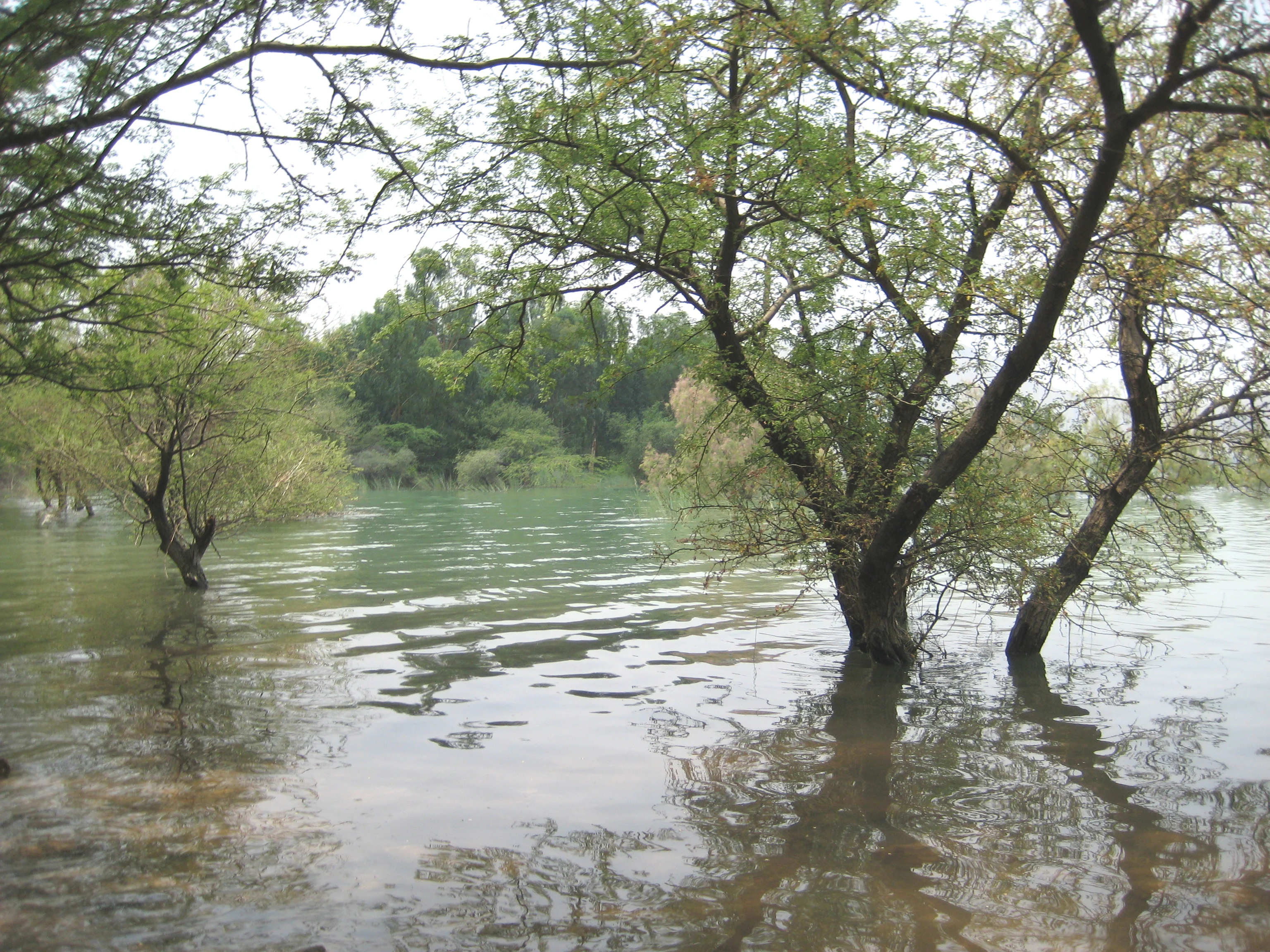
A calm lake with several trees growing out of the water, their trunks partially submerged. Green foliage covers the trees and the distant shoreline under an overcast sky.
Tanda Lake during the monsoon season, with trees partially submerged in the flooded waters.

Tanda Dam history and protected-area timeline

The reservoir now known as Tanda Dam was inaugurated by the then President of Pakistan, Ayub Khan, in 1962, marking the formal recognition of the project during the early development phase of water infrastructure in Khyber Pakhtunkhwa. After a construction and filling period, the dam became operational on 17 July 1967, beginning its long role as an irrigation source for surrounding villages and farmland.

In the years following its operational launch, the ecological value of the reservoir became increasingly apparent. On 23 July 1976, the lake was designated as a Ramsar site under reference number 98, placing it within an international framework for the conservation and sustainable use of wetlands. This designation broadened the site's significance beyond water supply, framing it as a habitat warranting coordinated protection.

In more recent history, the lake has also become tied to public recreation in the Kohat District. That recreational use came under tragic focus on 29 January 2023, when a boat carrying children and adults from a local madrassa capsized on the water, resulting in the drowning of 49 children and two adults. The incident remains a defining moment in the modern history of the lake, drawing attention to public safety around the reservoir even as its ecological and agricultural roles continue.

Tanda Dam landscape and geographic character

Tanda Dam lies within the landscape of the Kohat District, where the terrain is shaped by low hills and seasonal drainage patterns typical of parts of Khyber Pakhtunkhwa. The reservoir occupies a basin within this setting, with stored water extending across roughly 405 hectares when at normal levels. The surrounding topography frames the lake as a broad, open stretch of water bordered by earthen slopes and rural land.

The reservoir's physical character reflects a balance between engineered features and natural surroundings. Canals radiate outward from the lake to distribute water, while the shorelines transition between managed banks and less developed margins where wetland vegetation can establish. The interplay of stored water, gently rising ground, and downstream agricultural plains gives the site a layered visual profile: calm open water in the middle distance, with cultivated lowlands and hill silhouettes beyond.

The lake's surface and its edges define much of the local scenery. Open water dominates the central view, while fringing habitats along portions of the shore support the birdlife for which the reservoir is recognized. The wider scene around Tanda Dam reads as a working rural landscape, where water management structures, fields, and natural contours share visual space.

Tanda Dam ecosystems, habitats, and plant life

Ecologically, Tanda Dam functions as a freshwater wetland embedded in a semi-arid regional setting. The reservoir's standing water and fringing marshy zones create conditions that differ sharply from the surrounding dryland terrain, allowing wetland-dependent plants and animals to establish populations that would not otherwise persist in the district.

Seasonal water levels shape the ecological rhythm of the site. During periods of higher storage, broader stretches of shoreline transition into shallow, vegetated margins that support aquatic invertebrates and feeding habitat for waterbirds. As levels shift through the year, the character of exposed mudflats, reedbeds, and open water changes, producing a dynamic wetland mosaic that is typical of small irrigation reservoirs in arid and semi-arid regions.

The combination of open water, sheltered shoreline, and surrounding dryland gives the site an ecological edge effect that is often richer than either the lake or the hills alone. This gradient supports both resident wetland species and seasonal visitors, anchoring Tanda Dam's place within Pakistan's network of recognized freshwater habitats.

Tanda Dam wildlife and species highlights

Tanda Lake's wildlife profile is anchored in its role as a wintering ground for migratory waterbirds. Each winter, the reservoir receives visitors from distant breeding regions, with documented arrivals from Siberia and the Caspian region. These seasonal migrants join local and regional birdlife, making the lake a focal point for waterbird activity in the Kohat District.

The open water and shallow margins of the reservoir provide feeding and resting habitat for a variety of waterbird groups typical of inland Pakistani wetlands. Ducks, waders, and other water-dependent species use the lake during the cooler months, taking advantage of relatively undisturbed habitat compared with more heavily settled water bodies. The site's Ramsar recognition underscores the importance of this seasonal birdlife to its conservation value.

While birds are the most visible wildlife signal at Tanda Dam, the wetland environment also supports the smaller fauna typical of freshwater reservoirs in semi-arid landscapes, including fish populations and aquatic invertebrates that underpin the food web. Together, resident and migratory species give the lake a clear and distinctive wildlife identity within the region.

Tanda Dam conservation status and protection priorities

Tanda Dam's principal conservation significance lies in its designation as a Ramsar site. Listed on 23 July 1976 under reference number 98, the reservoir is formally recognized under the Ramsar Convention as a wetland of international importance, binding it to frameworks for the conservation and wise use of wetlands. This status places the lake alongside other nationally and internationally significant water bodies in Pakistan's protected-area network.

Beyond its treaty status, the lake's conservation value is rooted in its function as a reliable freshwater habitat within an otherwise dry landscape. By holding water year-round for irrigation, the reservoir sustains wetland conditions that support migratory birds, resident waterbird populations, and the broader aquatic community. Its protected status reinforces the need to manage the site in ways that maintain its ecological character alongside its agricultural role.

Recognition under the Ramsar Convention also gives the lake visibility in international conservation discussions. The combination of working reservoir and protected wetland creates a model in which infrastructure and habitat values coexist, and where conservation planning must account for irrigation demands, recreational use, and the protection of migratory and resident wildlife.

Tanda Dam cultural meaning and human context

Tanda Dam is deeply woven into the rural life of the Kohat District. The reservoir's canals feed a network of villages, including Jerma, Tappi, Baqizai, Dhoda, and Shahpur, linking the lake to everyday agricultural routines and to the livelihoods of farming households across the surrounding countryside. In this sense, the dam is not just a natural feature but a shared community resource.

Religious and educational institutions in the district, including local madrassas, have historically organized outings to the lake, reflecting its role as a familiar gathering and recreational spot. The strong public memory of the 2023 boat disaster has also reshaped local conversations about safety and stewardship of the site, embedding the lake more deeply into community experience.

The broader cultural setting of Kohat, with its mix of Pashtun rural traditions and longstanding agricultural practices, frames how Tanda Dam is used and understood. The lake operates as both a working piece of water infrastructure for farming communities and as a familiar natural landmark within the district's identity.

Top sights and standout views in Tanda Dam

Tanda Dam combines practical irrigation function with formal international wetland recognition, making it unusual among small Pakistani reservoirs. Its Ramsar designation, dating to 1976, signals lasting ecological importance, while the steady canal-based supply of water to surrounding villages anchors its role in regional agriculture.

The lake's seasonal role as a wintering ground for migratory waterbirds from Siberia and the Caspian region adds a distinctive natural highlight, drawing attention to the site's value as a refuge in a largely dry landscape. Together, these features make Tanda Dam a compact but layered destination, where water management, biodiversity, and local community life intersect.

Best time to visit Tanda Dam

The cooler winter months tend to be the most distinctive period at Tanda Dam, when migratory waterbirds from Siberia and the Caspian region arrive and concentrate around the reservoir. This season typically brings the richest birdlife activity and the most dynamic wetland scenes along the lake's margins.

Spring and autumn transitional periods can also offer appealing conditions, with milder temperatures and shifting water levels that alter the appearance of the shoreline. Summer visits coincide with higher agricultural use of stored water and warmer, drier conditions across the surrounding Kohat landscape, shaping both the atmosphere of the lake and the patterns of activity around it.

Monthly climate preview

Long-term representative temperature and precipitation averages for Khyber Pakhtunkhwa

Tanda Dam Climate Normals and Monthly Weather Patterns

Historical data from 1991 to 2000 reveals significant thermal variation across the twelve recorded monthly periods, alongside distinct precipitation shifts at the representative coordinate. Examining the complete monthly climate profile provides deeper context on sustained annual temperature ranges and precipitation rhythms.
Annual mean22 °C
9 °C33 °C
Jan
Feb11°
Mar16°
Apr22°
May28°
Jun33°
Jul32°
Aug30°
Sep27°
Oct22°
Nov16°
Dec12°
Warmest month
June

32.5 °C

Coolest month
January

9.1 °C

Wettest month
August

2.6 mm/day

Driest month
December

0.5 mm/day

Park location guide

Geography guide, regional context, and park location map for Tanda Dam

Tanda Dam park geography, regions, and map view in Pakistan

Understand where Tanda Dam sits in Pakistan through a broader geographic reading of the surrounding landscape, nearby location context, and its mapped position within the national park landscape.

How Tanda Dam fits into Pakistan

Pakistan, officially the Islamic Republic of Pakistan, is a federal parliamentary Islamic republic in South Asia. It is the fifth-most populous country and the 33rd-largest by area. The country gained independence from British India in 1947 and has a diverse history spanning ancient civilizations including Mehrgarh and the Indus Valley Civilisation. Pakistan shares maritime borders with Oman and is bounded by the Arabian Sea, Gulf of Oman, and several neighboring countries.

Wider geography shaping Tanda Dam in Pakistan

Pakistan is located in South Asia, bordered by the Arabian Sea to the south, the Gulf of Oman to the southwest, and shares land borders with India to the east, Afghanistan to the west, Iran to the southwest, and China to the northeast. The country also shares a maritime border with Oman in the Gulf of Oman. The Wakhan Corridor in Afghanistan separates Pakistan from Tajikistan in the northwest.

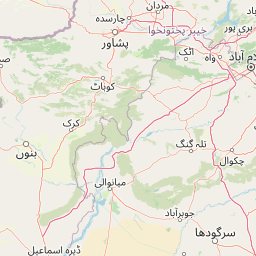
Map view of Tanda Dam

Use this park location map to pinpoint Tanda Dam in Pakistan, understand its exact geographic position, and read its mapped placement within the surrounding landscape more clearly.

Pigeon | © OpenStreetMap contributors

Location context for Tanda Dam

Khyber Pakhtunkhwa

Explore high-resolution photography capturing the terrain, waterbodies, and seasonal birdlife of Kohat

Tanda Dam Photos and Landscape Scenery: Visualizing the Protected Wetland Habitat

Examine detailed imagery showcasing the open reservoir waters, low surrounding hills, and wetland margins that define the physical environment. Visual documentation reveals the interplay of managed agricultural infrastructure and natural wildlife habitats across the protected landscape.

A calm lake with several trees growing out of the water, their trunks partially submerged. Green foliage covers the trees and the distant shoreline under an overcast sky.

Park atlas

Compare regional wetlands, reservoirs, and natural habitats across the district

Explore Parks Near Tanda Dam and Surrounding Protected Landscapes

Browse nearby national parks and protected areas sharing the wider geography of the Kohat District. Continuing outward from Tanda Dam reveals connected wetland ecosystems and regional conservation lands.
National parkAttock District
About 84 km away#1 closest

East

Kala Chitta National Park: Protected Dry Temperate Forest in Attock District, Pakistan

Discover unique hill landscapes and a rare ecosystem on the Pothohar Plateau.

Kala Chitta National Park represents a crucial protected area in Punjab, Pakistan, safeguarding a distinct dry temperate forest ecosystem that is uncommon in the Pothohar Plateau's heavily agricultural landscape. The park's terrain comprises rolling hills and intervening plains, contributing to its ecological richness and providing valuable mapped landscape context. Explore the geographic importance of this national park and its role in preserving a vital natural habitat.

Area
363.77 km²
Established
1983
IUCN
II
Relief
Mixed relief
National parkPunjab
About 119 km away#2 closest

Southeast

Chinji National Park: National Park Atlas, Salt Range Geography, and Protected Landscape

Discover the unique eroded terrain and semi-arid ecosystems of Punjab, Pakistan.

Chinji National Park is a protected national park located in the Punjab province of Pakistan, specifically within the historic Salt Range. This park is characterized by its deeply eroded terrain, composed of sandstone and igneous rock formations, shaped by seasonal streams that lead towards the Soan River. As a key example of a semi-arid mountain ecosystem within the Baluchistan xeric woodlands ecoregion, Chinji National Park offers significant insights into the geological heritage and unique biodiversity of central Pakistan.

Area
60.95 km²
Established
1987
IUCN
II
Relief
Upland
A wide watercolor illustration showing a calm body of water in the foreground, green trees and reeds along the shoreline, and soft rolling hills in the background under a pale sky
Protected areaKhushab District
About 119 km away#3 closest

Southeast

Uchhali Complex Protected Area: Geography, Salt Range Lakes, and Wetland Mapping

Key protected wetland landscape in the Soon Valley of Punjab

The Uchhali Complex serves as a critical wetland system characterized by the brackish and saline waters of Khabikki, Uchhali, and Jahlar lakes. Situated in the Soon Valley, this protected area offers a unique geographic perspective on the interplay between the mineralized geology of the Salt Range and the surrounding semi-arid terrain. This detail overview examines the site as a landmark habitat for migratory waterbirds and a defining feature of the Khushab District landscape.

Area
12.43 km²
Established
1996
Access
Access unknown
Scope
Terrestrial
National parkPunjab
About 131 km away#4 closest

East

Kheri Murat National Park: Protected Scrub Forest and Wildlife Conservation in Punjab

Explore the mapped terrain and protected landscape context.

Discover Kheri Murat National Park, a recent national park designation located in Punjab, Pakistan, situated on the rolling hills of the Kala Chitta Range. This protected area features a distinct subtropical thorn scrub forest ecosystem, providing essential habitat for wildlife, including the Punjab urial, and serving as a critical site for bird conservation. Its unique landscape offers valuable insights into regional geography and the preservation of natural wilderness within a predominantly agricultural province, making it a noteworthy entity for atlas exploration.

Area
35.37 km²
Established
2020
IUCN
II
Relief
Mountain
Wildlife reservePunjab
About 132 km away#5 closest

Southeast

Chumbi Surla Wildlife Sanctuary: Geographic Overview of Punjab Foothill Habitats

Mapping protected scrub forests and ridges in Khushab and Chakwal

Covering thousands of acres of contiguous reserve forest, Chumbi Surla Wildlife Sanctuary represents a crucial protected ecosystem within the Punjab landscape. This high-altitude scrub environment provides an essential refuge for the Punjab urial, characterized by deep valleys, stony slopes, and ridge systems that define the topography of the local Salt Range outliers.

Area
226.4 km²
Established
1978
IUCN
IV
Relief
Upland
National parkIslamabad Capital Territory
About 143 km away#6 closest

East

Margalla Hills National Park: Pakistan's Gateway to Himalayan Foothills Geography

Mapped protected landscape with rich Sino-Himalayan biodiversity.

Margalla Hills National Park, situated in the Islamabad Capital Territory, serves as Pakistan's most accessible national park and a vital entry point to the Himalayan foothills. This protected landscape is defined by its rugged mountain terrain, ranging from lower scrublands to higher pine and oak woodlands, with elevations up to 1,604 meters. The park's geological significance, with ancient marine fossil formations, adds a unique dimension to its natural identity. Discover the mapped boundaries and ecological richness that characterize this important protected area, offering insights into regional geography and diverse habitats.

Area
173.86 km²
Established
1980
IUCN
V
Relief
Mountain
National parkPakistan
About 150 km away#7 closest

South

Sheikh Badin National Park: Pakistan's Sulaiman Mountains Protected Landscape Explorer

Semi-arid terrain and rich herpetofauna habitat in Khyber Pakhtunkhwa.

Investigate Sheikh Badin National Park, a key protected area situated within Pakistan's Sulaiman Mountains. This national park showcases a distinctive semi-arid mountain terrain, characterized by rocky ridges and valleys, offering insights into ecological transition zones. Delve into the park's mapped boundaries and its significance as a habitat for diverse birdlife and herpetofauna within Pakistan's geography.

Area
155.4 km²
Established
2003
IUCN
II
Relief
Mountain
National parkPakistan
About 163 km away#8 closest

Southeast

Salt Range National Park: Pakistan's Protected Landscape for Geographic Atlas Exploration

Mapped boundaries and regional terrain context for a Pakistani national park.

Gain insight into Salt Range National Park, a significant national park established within Pakistan. This entry focuses on its role as a protected landscape, providing a mapped view of its geographic scope and environmental context. Understand how this park contributes to Pakistan's broader geography and offers opportunities for atlas-based discovery of its natural terrain.

Relief
Mountain
Scope
Terrestrial

Common questions about visiting, size, designation, and location context for Tanda Dam

Tanda Dam FAQs for park facts, access, geography, and protected area context

Find quick answers about Tanda Dam, including protected-area facts, park geography, trail and visitor context, and how the park fits into its surrounding country and regional landscape.
MoriAtlas Explorer

Continue Your Protected Areas Search Across the Global Atlas

Deepen your exploration by continuing the structured search for national parks and protected areas worldwide. Utilize the comprehensive filtering capabilities to compare different conservation landscapes and refine your understanding of global park geography. Discover more about the distribution and characteristics of protected natural areas.

Global natural geography