

Mori Atlas logo
National parkTerepaima National Park

Discover the mapped boundaries and regional geography of Terepaima National Park.

Terepaima National Park: Venezuela's Protected National Park Landscape

Terepaima National Park represents a distinct protected area within Venezuela's diverse geography. As a national park, it serves as a key entity for exploring mapped natural landscapes and understanding regional conservation. This entry provides a focused view of Terepaima National Park, ideal for atlas-based discovery of protected lands and their geographic context.

cloud forestnational parkVenezuelaAndes mountainsprotected areatropical forest

Terepaima National Park

National park

Park overview

Structured park overview, official facts, and landscape profile for Terepaima National Park

Terepaima National Park park facts, protected area profile, and essential visitor context

Review the core facts for Terepaima National Park, including designation, size, terrain, visitor scale, habitats, and operating context in one park-focused overview.

About Terepaima National Park

Terepaima National Park occupies a strategically important position in Venezuela's protected area network, preserving a representative sample of the country's Andean foothill ecosystems. The park's location southeast of Barquisimeto places it at the intersection of multiple ecological zones, creating conditions that support remarkable biodiversity despite its relatively modest total area. The mountainous terrain features steep valleys and ridgelines that channel moisture from passing clouds, sustaining the cloud forest communities that define the park's ecological character. This moisture regime supports a dense canopy of broadleaf evergreen trees, epiphytic plants, and a rich understory that thrives in the consistently humid conditions. The park's establishment in 1976 reflected growing recognition in Venezuela of the need to protect these montane forest environments from expanding agricultural and pastoral activities that were transforming the surrounding landscape.

Quick facts and research context for Terepaima National Park

Terepaima National Park covers 18,971 hectares in the Andean foothills of western Venezuela, straddling Lara and Portuguesa States. The park was officially established on April 14, 1976, through a national decree aimed at protecting the region's biodiversity. Average temperatures within the park range from 19 to 26 degrees Celsius, creating a mild climate conducive to diverse ecological communities. The protected area encompasses portions of three municipalities: Iribarren, Palavecino, and Simón Planas, making it a regionally significant conservation landmark for the Lara state area.

Protection and recognition

Verifying the 1976 establishment framework and terrestrial protection history.

Documented Protection Status and Conservation Profile of Terepaima National Park

Establishment records from 1976 mark the formal designation of Terepaima National Park as a dedicated terrestrial protected area. Researchers and geographers can analyze the formal administrative framework and verified boundary data to assess how the terrestrial reserve fits into regional ecological networks.

Protection details

Protection scope
Terrestrial
Designated year
1976
Park context

Deeper park guide and search-rich context for Terepaima National Park

Terepaima National Park history, landscape, wildlife, and travel context

Explore Terepaima National Park through its history, landscape character, ecosystems, wildlife, conservation priorities, cultural context, and seasonal travel timing in a structured park guide built for atlas discovery and search intent.

Why Terepaima National Park stands out

Terepaima National Park is best known for its extensive cloud forest ecosystems, which represent a critical habitat type in the Venezuelan Andes. The park protects some of the last remaining tracts of montane forest in the Lara-Portuguesa region, featuring characteristic cloud forest vegetation including endemic tree species such as mountaineers, salvio, and mountain manzanilla, along with diverse fern communities. The park also serves as a refuge for numerous endangered mammal species, including several species of primates, large cats, and the distinctive front and jaguar bear populations that inhabit the forested slopes.

Terepaima National Park history and protected-area timeline

Terepaima National Park was officially established through a presidential decree on April 14, 1976, marking it as one of Venezuela's younger national parks created during a period of increased environmental awareness in the country. The creation of the park responded to growing concerns about deforestation and habitat loss in the Andean foothills of Lara and Portuguesa states, where agricultural expansion was progressively encroaching on native forest areas. The decree specifically designated the area for the protection of both flora and fauna, recognizing the ecological significance of the cloud forest ecosystem and its resident wildlife populations. Since its establishment, the park has served as a refuge for species displaced from surrounding developed areas and continues to function as a living laboratory for ecological research and environmental education.

Terepaima National Park landscape and geographic character

The landscape of Terepaima National Park is defined by its position in the foothills of the Venezuelan Andes, where the terrain rises sharply from the surrounding lowlands into steep mountainous terrain. The park encompasses a complex arrangement of ridges, valleys, and ravines that create diverse microclimates and exposure conditions across its extent. Elevation within the park supports distinct vegetation zones, with lower slopes covered in transitional forest transitioning into dense cloud forest as altitude increases. The interaction between the mountainous topography and moisture-bearing winds from the Caribbean creates the persistent cloud cover that characterizes the higher elevations, depositing moisture directly onto vegetation and maintaining the saturated conditions that sustain the cloud forest ecosystem.

Terepaima National Park ecosystems, habitats, and plant life

The ecological character of Terepaima National Park centers on its cloud forest ecosystems, which represent one of the most biodiverse habitat types in the Neotropics. The upper elevations of the park feature closed-canopy forest dominated by broadleaf evergreen species adapted to the cool, constantly moist conditions. Characteristic tree species include the locally named mountaineers and salvio, along with mountain manzanilla, all of which form the structural framework of the forest. The dense canopy supports a rich epiphytic community including numerous fern species that carpet the forest floor and grow abundantly on tree trunks and branches. These ferns thrive in the constantly humid microclimate created by the cloud cover, creating a verdant understory distinctive to this elevation zone.

Terepaima National Park wildlife and species highlights

Terepaima National Park protects important populations of Neotropical wildlife, with particular significance for several mammal species of conservation concern. The park provides habitat for the endangered front and jaguar bear, two of the larger mammalian predators in the Venezuelan fauna. Primate populations include howler monkeys and capuchin monkeys, both of which are well-established in the forest canopy. Additional mammalian residents include armadillos (cachicamos), agoutis (lapas), opossums (rabipelados), coatis (mapurites), ocelots (cunaguaros), deer, tapirs (dantas), and peccaries (báquiros). The presence of large predators like pumas indicates a functioning food web and healthy ecosystem integrity.

Terepaima National Park conservation status and protection priorities

Terepaima National Park represents an important conservation unit within Venezuela's protected areas system, preserving critical habitat for both endemic species and those with restricted distributions in the Andean region. The cloud forest ecosystem protected within the park boundaries serves as a watershed for downstream agricultural areas, providing ecological services that extend beyond the park's immediate borders. The protection of this area ensures the preservation of genetic diversity in forest species and maintains corridors for wildlife movement between higher and lower elevation habitats. The park's multi-municipal jurisdiction creates challenges for coordinated management but also ensures that conservation considerations are integrated into regional land-use planning.

Terepaima National Park cultural meaning and human context

While Terepaima National Park is primarily valued for its ecological significance, the region has historical human presence that predates the protected area designation. The municipalities surrounding the park, particularly Iribarren, Palavecino, and Simón Planas, have agricultural traditions that have shaped the surrounding landscape. The park itself remains largely undeveloped, with human activity concentrated primarily along its periphery rather than within the protected core area.

Top sights and standout views in Terepaima National Park

The defining highlight of Terepaima National Park is its accessible cloud forest environment, which offers visitors the opportunity to experience Andean montane ecosystems relatively close to the urban center of Barquisimeto. The park's trail systems provide access to viewpoints overlooking the forested slopes and valleys, while the consistent moisture creates ideal conditions for observing fern diversity and experiencing the atmospheric quality of cloud forest environments. Wildlife observation opportunities focus primarily on primates and birds, though the cryptic nature of larger mammals means sightings require patience and appropriate timing.

Best time to visit Terepaima National Park

The optimal period for visiting Terepaima National Park falls during the dry season months when trails are more accessible and wildlife activity concentrates around remaining water sources. The park's high elevation location means that temperatures remain pleasant throughout the year, ranging between 19 and 26 degrees Celsius, though higher elevations can feel notably cooler, especially during overcast conditions when cloud cover reduces solar warming. Visitors should be prepared for the characteristic cloud forest conditions, where moisture is present regardless of season and trail conditions can become slippery following rainfall.
Monthly climate preview

Mapping historical temperature ranges and monthly rainfall trends at seven hundred meters elevation

Terepaima National Park Climate Normals and Long Term Weather Patterns

Historical measurements at seven hundred meters elevation reveal steady mean temperatures between twenty-three and twenty-five degrees Celsius alongside varied seasonal precipitation. Accessing the full monthly profile reveals detailed maximum and minimum ranges, daily rainfall averages, and long term climatology cycles for Terepaima National Park.
Annual mean24 °C
23 °C25 °C
Jan24°
Feb24°
Mar25°
Apr25°
May25°
Jun24°
Jul23°
Aug24°
Sep24°
Oct24°
Nov24°
Dec23°
Warmest month
April

25.4 °C

Coolest month
December

23.4 °C

Wettest month
July

3.7 mm/day

Driest month
February

0.5 mm/day

Park location guide

Geography guide, regional context, and park location map for Terepaima National Park

Terepaima National Park park geography, regions, and map view in Venezuela

Understand where Terepaima National Park sits in Venezuela through a broader geographic reading of the surrounding landscape, nearby location context, and its mapped position within the national park landscape.

How Terepaima National Park fits into Venezuela

Venezuela is a country in northern South America with coastline along the Caribbean Sea and Atlantic Ocean. It borders Colombia, Brazil, Guyana, and Trinidad and Tobago. The country has an area of approximately 916,445 km² and a population of about 31.8 million. Caracas is the capital and largest city. Venezuela consists of 23 states and the Capital District.

Wider geography shaping Terepaima National Park in Venezuela

Venezuela is located on the northern coast of South America. The continental territory is bordered by the Caribbean Sea and Atlantic Ocean to the north, Colombia to the west, Brazil to the south, and Guyana to the east. Trinidad and Tobago lies to the northeast. The country includes various islands and islets in the Caribbean Sea known as the Federal Dependencies.

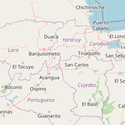
Map view of Terepaima National Park

Use this park location map to pinpoint Terepaima National Park in Venezuela, understand its exact geographic position, and read its mapped placement within the surrounding landscape more clearly.

Pigeon | © OpenStreetMap contributors

Location context for Terepaima National Park

LaraPortuguesa
Park atlas

Map the regional context of protected areas, from cloud forests to adjacent montane landscapes in Venezuela.

Nearby National Parks and Protected Areas: Expanding Your Discovery from Terepaima National Park

Browse a curated list of national parks and protected areas located in the region surrounding Terepaima National Park, including other significant cloud forest ecosystems and Andean foothill environments. This geographical overview helps you compare conservation landscapes, trace mountain wildlife habitats, and understand the broader protected-area network in western Venezuela.
National parkLara State
About 45 km away#1 closest

Northwest

Cerro Saroche National Park: A National Park within Lara State's Geography

Explore the protected landscape and mapped boundaries.

Cerro Saroche National Park in Lara State, Venezuela, is a distinct protected area offering a valuable perspective for geographic and atlas exploration. This page provides essential details about its identity as a national park, highlighting its place within the regional landscape. Understanding Cerro Saroche National Park helps in appreciating the distribution of protected lands and their geographical significance across Venezuela.

Area
322.94 km²
Established
1989
IUCN
II
Relief
Mountain
National parkVenezuela
About 45 km away#2 closest

Southwest

El Guache National Park: Venezuela's Protected Andean Foothill National Park

Map exploration of vital river basins and natural landscapes.

El Guache National Park is a protected national park in Venezuela, safeguarding the headwaters of five key rivers. Its landscape comprises mountainous terrain within the Andean foothills, crucial for watershed protection and regional biodiversity. This entry provides detailed geographic context, allowing for an atlas-style exploration of the park's mapped boundaries and its role as a vital protected area.

Area
122 km²
Established
1992
IUCN
II
Relief
Mountain
National parkLara State
About 51 km away#3 closest

Southwest

Yacambú National Park National Park: Protected Cloud Forest Landscape in Lara State

Mapped terrain and significant orchid diversity in Venezuela's Andean foothills.

Yacambú National Park is a significant national park in Venezuela's Lara State, protecting crucial humid cloud forest ecosystems in the Andean foothills. The park's terrain is defined by the mountainous topography of the Portuguesa Mountain Range, supporting a rich diversity of flora, including numerous orchid species. Its role in watershed protection for nearby regions underscores its importance as a conserved natural landscape with vital ecological functions.

Area
146 km²
Established
1962
IUCN
II
Relief
Mountain
National parkCojedes
About 66 km away#4 closest

East

Parque Nacional Tirgua: Mapping Protected Foothills and River Systems in Cojedes

A vital watershed preservation unit in the Venezuelan piedmont.

Spanning the border between Cojedes and Yaracuy, Parque Nacional Tirgua acts as a significant ecological refuge defined by its irregular, hilly terrain. The area protects the source of the Tirgua River, regulating regional water flow through a mosaic of seasonal forests and broken slopes. This geographic context highlights the importance of the park within the broader network of Venezuelan protected lands.

Area
910 km²
Established
1992
IUCN
II
Relief
Upland
National parkVenezuela
About 66 km away#5 closest

East

Tirgua National Park: Geographic Overview and Protected Mountain Landscape Map

Examining the high altitude terrain and watersheds of Lara State

Tirgua National Park is a protected area situated in the mountainous region of Lara State in western Venezuela. This location covers diverse cloud forest environments and steep river valleys that are critical to the Tocuyo River basin. The area provides a unique window into the neotropical mountain ecosystems of the Venezuelan Andes, showcasing rugged topography and distinct highland watersheds.

IUCN
II
Scope
Terrestrial
National parkVenezuela
About 95 km away#6 closest

Northeast

Yurubí National Park: A National Park in Venezuela for Protected Landscape Exploration

Explore mapped boundaries and regional geography.

Yurubí National Park represents a distinct protected area within Venezuela, offering valuable data for geographic exploration and atlas-based understanding. This national park's identity is defined by its mapped boundaries and its role in the regional landscape context of northern South America. Delve into its protected territory to gain insights into Venezuela's natural geography and conservation landscapes.

Area
236.7 km²
Established
1960
IUCN
II
Relief
Mountain
National parkVenezuela
About 110 km away#7 closest

North

Cueva de la Quebrada del Toro National Park: Venezuelan National Park Protected Landscape

Explore its mapped boundaries and regional geographic context.

This page details Cueva de la Quebrada del Toro National Park, highlighting its status as a national park within Venezuela. Understand the park's geographic setting, its role as a protected landscape, and its mapped presence within the country's natural reserves. It provides essential context for exploring its protected boundaries and regional significance for atlas-based discovery.

Area
48.85 km²
Established
1961
IUCN
II
Relief
Upland
National parkVenezuela
About 111 km away#8 closest

Southwest

Dinira National Park: Protected Watershed and Andean Mountain Landscape

Explore its rugged terrain and páramo ecosystem.

Dinira National Park is a significant protected area in Venezuela, covering rugged Andean terrain vital for watershed protection. This national park features dramatic mountain landscapes, including the Humocaro Mountains and the Los Nepes páramo zone, supporting diverse cloud forest and high-altitude ecosystems. Understanding Dinira National Park offers insight into the geographic context of the Cordillera de Mérida and its hydrological importance.

Area
453.28 km²
Established
1988
IUCN
II
Relief
Mountain

Common questions about visiting, size, designation, and location context for Terepaima National Park

Terepaima National Park FAQs for park facts, access, geography, and protected area context

Find quick answers about Terepaima National Park, including protected-area facts, park geography, trail and visitor context, and how the park fits into its surrounding country and regional landscape.
MoriAtlas Explorer

Continue Your Protected Areas Search Across the Global Atlas

Deepen your exploration by continuing the structured search for national parks and protected areas worldwide. Utilize the comprehensive filtering capabilities to compare different conservation landscapes and refine your understanding of global park geography. Discover more about the distribution and characteristics of protected natural areas.

Global natural geography