

Mori Atlas logo
National parkThe Lakes National Park

Explore the geographic boundaries and distinct landscape features of this significant national park.

The Lakes National Park: Mapped Protected Wetlands within Victoria's Gippsland Lakes

The Lakes National Park stands as a crucial protected area within the East Gippsland region of Victoria, Australia, defining a significant portion of the Gippsland Lakes system. This national park encompasses 2,390 hectares of coastal wetland environments, islands, and peninsulas, creating a mosaic of aquatic and terrestrial habitats. Established as a conservation legacy, its mapped boundaries protect vital ecosystems and offer a unique lens through which to explore regional geography and protected land distribution.

coastal wetlandsisland habitatsbirdwatching Gippsland Lakespaperbark forestscoastal lagoons

The Lakes National Park

National park

Park overview

Structured park overview, official facts, and landscape profile for The Lakes National Park

The Lakes National Park park facts, protected area profile, and essential visitor context
Review the core facts for The Lakes National Park, including designation, size, terrain, visitor scale, habitats, and operating context in one park-focused overview.

About The Lakes National Park

The Lakes National Park protects a significant portion of the Gippsland Lakes coastal ecosystem, a vast inland lagoon system fed by rivers and tidal inlet from the Tasman Sea. The park's position on the eastern shore places it at the interface between terrestrial forests and expansive wetland waters, creating a transitional landscape of high ecological diversity. The Gippsland Lakes themselves represent a modified natural system where historical hydraulic works have altered hydrological patterns, yet the remaining wetland areas retain substantial biodiversity value. The park includes several distinct landscape components: the open waters of Lake Victoria and Lake Reeve, the vegetated Sperm Whale Head peninsula, and the forested islands of Rotamah and Little Rotamah. These different zones support varied plant communities ranging from aquatic reeds and sedges through to paperbark woodlands and dry sclerophyll forests on the higher ground. The management arrangement reflects contemporary conservation practice in Victoria, with Parks Victoria working jointly with the Gunaikurnai traditional owners to care for Country and maintain ecological values.

Quick facts and research context for The Lakes National Park

The Lakes National Park occupies 2,390 hectares along the eastern shore of the Gippsland Lakes in East Gippsland, Victoria. The park is managed by Parks Victoria in partnership with the Gunaikurnai traditional owners. The park boundary encompasses Lake Victoria and Lake Reeve, along with Sperm Whale Head peninsula and the islands of Rotamah and Little Rotamah. The area was first protected as a nature reserve in 1927 before achieving national park status in 1956.

Park context

Deeper park guide and search-rich context for The Lakes National Park

The Lakes National Park history, landscape, wildlife, and travel context
Explore The Lakes National Park through its history, landscape character, ecosystems, wildlife, conservation priorities, cultural context, and seasonal travel timing in a structured park guide built for atlas discovery and search intent.

Why The Lakes National Park stands out

The park is best known for its extensive coastal wetland systems that form part of the broader Gippsland Lakes. The combination of shallow lakes, reed beds, paperbark forests, and sandy substrates creates a distinctive Ramsar-worthy wetland character. Rotamah Island represents a particular ecological highlight, supporting significant bird breeding colonies and providing habitat for waterfowl, waders, and migratory species. The peninsula areas offer elevated vantage points across the lake system while the fringing forests provide important habitat corridors.

The Lakes National Park history and protected-area timeline

The protection of this area began in 1927 when 1,451 hectares were set aside as a nature reserve, representing an early recognition of the region's natural values during the interwar period. The formal proclamation of The Lakes National Park occurred in 1956, elevating the protection status and acknowledging the area's significance within Victoria's developing national park system. The addition of Rotamah Island and Little Rotamah Island in 1978 reflected growing understanding of the importance of island habitats for breeding bird populations and the need for comprehensive ecosystem protection. The park's management has evolved to incorporate traditional owner partnership, with the Gunaikurnai people recognized as joint managers reflecting their ongoing connection to Country. This collaborative management approach represents a significant development in Victorian park management philosophy.

The Lakes National Park landscape and geographic character

The physical geography of The Lakes National Park is defined by its position within the Gippsland Lakes basin, a large coastal lagoon system separated from the open ocean by a narrow sand barrier. The park's terrain is predominantly flat to gently undulating, with elevations rarely exceeding a few meters above sea level. The shoreline features extensive reed beds and mudflats that transition into deeper water zones toward the lake centers. Sperm Whale Head peninsula provides a slightly more elevated landform projecting into Lake Victoria, offering views across the water and supporting drier vegetation communities on its crests. Rotamah and Little Rotamah Islands add island landscapes to the park's diversity, with their vegetated slopes rising modestly above the surrounding waters. The substrate throughout much of the park consists of unconsolidated sediments, sands, and organic soils that support the wetland plant communities.

The Lakes National Park ecosystems, habitats, and plant life

The ecological character of The Lakes National Park centers on its wetland habitats, which form part of the broader Gippsland Lakes Ramsar site. The park contains several distinct habitat types: permanently inundated open water areas, seasonal wetlands with variable inundation, reed beds dominated by emergent aquatic vegetation, paperbark woodlands on the lake margins, and drier forest communities on elevated islands and peninsulas. The Gippsland Lakes system supports internationally significant populations of migratory waterbirds, with the wetland areas providing crucial feeding and breeding habitat. The vegetation patterns reflect the wet-dry fluctuations of the lake system, with salt-tolerant species in the more brackish zones and freshwater-dependent communities in areas with more consistent freshwater input. The islands support remnant forest patches that provide stepping-stone habitat for terrestrial species.

The Lakes National Park wildlife and species highlights

The wildlife of The Lakes National Park is dominated by the bird communities that utilize the wetland habitats. The Gippsland Lakes support over 50 species of waterbirds, with the park's reed beds and shallow waters providing important feeding and nesting areas. Notable species include various duck species, cormorants, swans, and herons that concentrate in the wetland areas during breeding season. The islands provide secure nesting sites away from terrestrial predators, supporting significant colonies of colonial nesting waterbirds. The surrounding woodlands and forest edges support terrestrial bird species, while the open waters attract fishing birds including pelicans and sea eagles. The reptile and mammal communities are less documented but include species adapted to wetland and forest edge environments.

The Lakes National Park conservation status and protection priorities

The Lakes National Park contributes to the protection of Victoria's coastal wetland systems, which have been significantly reduced by historical drainage and modification. The park forms part of the Gippsland Lakes system that has been recognized as a Ramsar wetland of international importance, placing it within the global framework of protected wetlands. The management partnership with Gunaikurnai traditional owners brings Indigenous knowledge and cultural values into conservation planning, reflecting contemporary understanding that effective environmental protection requires integration of ecological and cultural perspectives. The park's protected status helps maintain ecological connectivity between wetland habitats and supports the resilience of bird populations that depend on the Gippsland Lakes network.

The Lakes National Park cultural meaning and human context

The Lakes National Park lies within the traditional Country of the Gunaikurnai people, who have maintained continuous connection to these lands and waters over thousands of years. The Gippsland Lakes hold deep cultural significance for Gunaikurnai communities, with the wetland areas providing traditional food resources and supporting cultural practices. The partnership between Parks Victoria and Gunaikurnai traditional owners represents a significant model for collaborative protected area management in Victoria. This arrangement acknowledges that effective conservation requires respecting and incorporating Indigenous perspectives on land and water management.

Top sights and standout views in The Lakes National Park

The Lakes National Park offers distinctive wetland landscapes characterized by extensive reed beds, scattered paperbark woodlands, and expansive shallow waters. Rotamah Island provides a particular highlight, accessible by boat and offering opportunities to experience the island's forest environments and birdlife. The peninsula areas provide scenic outlooks across the lake system, while the wetland margins support prolific waterbird populations. The combination of island, peninsula, and fringing wetland environments creates a diverse landscape within a relatively compact protected area.

Best time to visit The Lakes National Park

The park can be visited throughout the year, though autumn and spring typically offer the most comfortable conditions for outdoor exploration. Birdwatching opportunities are particularly good during the warmer months when waterbird breeding activity peaks and migratory species are present. The wetland landscapes shift in character with seasonal water level changes, affecting the visual appearance and accessibility of different areas. Winter visits offer the advantage of fewer visitors and the opportunity to observe large flocks of waterfowl congregating in the remaining open water areas.
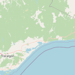
Park location guide

Geography guide, regional context, and park location map for The Lakes National Park

The Lakes National Park park geography, regions, and map view in Australia
Understand where The Lakes National Park sits in Australia through a broader geographic reading of the surrounding landscape, nearby location context, and its mapped position within the national park landscape.

How The Lakes National Park fits into Australia

Australia is a constitutional monarchy and federal parliamentary democracy comprising six states and ten territories. With a population of nearly 28 million, it is one of the world's most urbanised countries, with most people concentrated on the eastern seaboard. The country has a high Human Development Index and is known for its cultural diversity, ancient Aboriginal heritage, and unique wildlife.

Wider geography shaping The Lakes National Park in Australia

Australia occupies the entire Australian continent, the island of Tasmania, and numerous smaller islands. It is the world's flattest and driest inhabited continent, featuring vast deserts in the interior (the Outback), tropical rainforests along the eastern coast, and a coastline bordering the Indian and Pacific Oceans.

Map view of The Lakes National Park

Use this park location map to pinpoint The Lakes National Park in Australia, understand its exact geographic position, and read its mapped placement within the surrounding landscape more clearly.

Pigeon | © OpenStreetMap contributors
Park atlas

Trace the regional geography and connected protected landscapes across Victoria's East Gippsland.

Explore Nearby National Parks and Protected Areas Around The Lakes National Park
Browse a curated selection of national parks and protected areas located geographically near The Lakes National Park, exploring similar coastal wetland ecosystems and adjacent landforms. This comparison view provides essential geographic context and reveals how different conservation landscapes connect within Victoria's wider protected area network.
Marine protected area

Ninety Mile Beach Marine National Park: Victoria's Coastal Marine Protected Area

Mapped boundaries and temperate marine landscape context.

Ninety Mile Beach Marine National Park represents a significant commitment to marine conservation along the eastern Victorian coast. This protected area safeguards the underwater ecosystems adjacent to the celebrated Ninety Mile Beach, a nearly 100-kilometer stretch of continuous sandy shoreline. Its establishment in 2002 preserves the marine biodiversity and coastal landscape character of this region, forming an integral part of Victoria's network of protected coastal environments and offering a distinct view of Australia's marine geography.

Area
27.5 km²
Established
2002
IUCN
II
Scope
Marine
National park

Alpine National Park: Victoria's Expansive National Park in the Great Dividing Range

Mapping significant alpine, subalpine, and mountain wilderness landscapes.

Alpine National Park represents Victoria's largest protected area, safeguarding critical alpine and subalpine environments across the Great Dividing Range. This national park encompasses vast mountainous terrain, including Victoria's highest peaks like Mount Bogong, and the expansive Bogong High Plains known for their unique grassland and woodland ecosystems. The park's protected landscape offers rich opportunities for geographic discovery and understanding its place within Australia's significant mountain wilderness regions.

Area
6,474 km²
Established
1989
IUCN
II
Relief
Mountain
National park

Tarra-Bulga National Park: Ancient Mountain Ash Forest Protected Landscape in Victoria

Explore mapped fern gullies and temperate rainforest ecosystems.

Tarra-Bulga National Park is a protected national park in Victoria, Australia, renowned for its spectacular old-growth mountain ash forests and lush fern gullies. This significant fragment of temperate rainforest offers a unique window into the region's natural heritage and geographic past. Discover the mapped landscape character, including towering trees and vibrant undergrowth, making it a key destination for protected-area exploration.

Area
15.22 km²
Established
1986
IUCN
II
Visitors
80K annual
National park

Snowy River National Park: A Deep Gorge Protected Landscape in Victoria, AU

Explore mapped terrain and vital alpine wilderness boundaries.

Snowy River National Park showcases Victoria's rugged natural geography with its dramatic mountain terrain and the spectacular Little River Gorge, the state's deepest. This national park, classified as a wilderness area for much of its expanse, protects critical habitats and diverse ecosystems across its mapped boundaries. Its significance as a protected landscape within the Australian Alps National Parks makes it a key destination for understanding regional geography and conservation efforts.

Area
987 km²
Established
1979
IUCN
II
Relief
Mountain
National park

Morwell National Park: Protected Landscape Diversity in Victoria's Strzelecki Ranges

Explore the mapped terrain and unique forest ecosystems.

Morwell National Park, an Australian national park in the Strzelecki Ranges, is celebrated for its extraordinary plant and animal diversity within a concentrated area. The park preserves critical wet sclerophyll forests and delicate temperate rainforest pockets within deep gullies, offering a distinct landscape character. Its establishment reflects a significant community-driven conservation effort, making it a valuable site for understanding regional protected-area geography and landscape richness.

Area
5.65 km²
Established
1966
IUCN
III
Relief
Highland
National park

Lind National Park: Historic Protected Landscape in East Gippsland, Victoria

Explore mapped boundaries and forested terrain within this early national park.

Lind National Park, established in 1925, is a key protected area in Victoria, Australia, preserving the characteristic forested landscapes of East Gippsland. Spanning 1,370 hectares, it offers a tangible connection to the state's early conservation efforts. The park's terrain is defined by temperate forest, characteristic of eastern Victoria's undulating geography, providing a clear example of protected woodland adjacent to the Princes Highway corridor. Its historical designation underscores its importance in the region's network of natural reserves and mapped landscapes.

Area
13.7 km²
Established
1925
IUCN
II
Visitors
3.5K annual
National park

Baw Baw National Park: Subalpine Granite Landscapes and Protected Area Geography

Discover Victoria's southernmost alpine wilderness.

Baw Baw National Park offers a rare glimpse into Australia's subalpine environment, characterized by striking granite boulder formations and iconic snow gum forests. As a protected national park, it safeguards unique ecosystems and habitats, including those for critically endangered species. This atlas entry details the park's distinctive landscape, its mapped boundaries, and its geographic significance as the southern edge of mainland alpine terrain.

Area
135.3 km²
Established
1979
IUCN
II
Relief
Mountain
National parkAustralia

Errinundra National Park: Australia's National Park Geographic Identity and Mapped Boundaries

Explore the protected landscape and natural terrain of this Australian national park.

Errinundra National Park offers a unique window into Australia's protected natural areas. This detailed view focuses on its role as a national park, providing structured information on its geographic footprint, mapped terrain, and position within the broader Australian landscape. Understand Errinundra National Park as a distinct entity for atlas-based discovery, focusing on its protected land characteristics and geographic context without visitor logistics.

Area
268.75 km²
Established
1988
IUCN
II
Relief
Upland

Common questions about visiting, size, designation, and location context for The Lakes National Park

The Lakes National Park FAQs for park facts, access, geography, and protected area context
Find quick answers about The Lakes National Park, including protected-area facts, park geography, trail and visitor context, and how the park fits into its surrounding country and regional landscape.
MoriAtlas Explorer

Continue Your Protected Areas Search Across the Global Atlas

Deepen your exploration by continuing the structured search for national parks and protected areas worldwide. Utilize the comprehensive filtering capabilities to compare different conservation landscapes and refine your understanding of global park geography. Discover more about the distribution and characteristics of protected natural areas.

Global natural geography