

Mori Atlas logo
National parkParque Nacional Tirgua

Mapping the piedmont terrain, hydrological systems, and seasonal forests of this Cojedes protected area.

Parque Nacional Tirgua: A Protected Foothill Landscape and Watershed in Northern Venezuela

(Parque Nacional Tirgua, General Manuel Manrique)

Parque Nacional Tirgua stands as a critical protected area in north-central Venezuela, where it serves as a primary hydrological unit for the Tirgua River headwaters. This landscape covers a rugged transition zone between the central llanos and the northern mountain ranges, characterized by complex foothill topography. The region supports extensive deciduous and semi-deciduous forests that sustain a variety of wildlife, including primates and large mammals within an irregular, broken terrain.

national parkwatershed protectionheadwaterstropical dry forestdeciduous forestsemi-deciduous forest

Parque Nacional Tirgua

National park

Park overview

Structured park overview, official facts, and landscape profile for Tirgua National Park

Tirgua National Park park facts, protected area profile, and essential visitor context

Review the core facts for Tirgua National Park, including designation, size, terrain, visitor scale, habitats, and operating context in one park-focused overview.

About Tirgua National Park

Tirgua National Park is a Venezuelan national park situated in the country's central-northern region, where the flat landscapes of the llanos begin to rise toward the foothills of the northern mountain system. It crosses administrative boundaries between Cojedes and Yaracuy states, occupying parts of the San Carlos, Anzoátegui, and Nirgua municipalities. This geographic position gives the park a transitional character, blending elements of the interior plains with the more broken topography of the piedmont.

Created on June 5, 1992, and managed by INPARQUES under IUCN Category II, the park covers roughly 910 square kilometers. Its full official name is Parque Nacional Tirgua, General Manuel Manrique. Despite its modest public profile compared with Venezuela's larger flagship parks, it plays an important local and regional role because of the hydrological systems it shelters.

The park's purpose is closely tied to water. The Tirgua River rises within the area, and the park is designed to protect these headwaters along with the surrounding slopes, drainage patterns, and forested catchments that sustain them. This function gives the park a practical importance beyond its scenic or ecological value, anchoring its identity around watershed preservation rather than purely touristic appeal.

Ecologically, Tirgua features seasonal forest types adapted to the climatic rhythm of north-central Venezuela, with deciduous and semi-deciduous formations dominating the tree canopy. These forests shelter a varied fauna, including monkeys, felines, tapirs, several snake species, and an exceptionally diverse avifauna that includes macaws, parrots, herons, toucans, and many other bird families.

As a whole, Tirgua is a quieter but ecologically meaningful component of Venezuela's national park system, defined more by its role as a water source and a transitional habitat zone than by dramatic landmarks or large-scale tourism infrastructure.

Quick facts and research context for Tirgua National Park

Tirgua National Park lies in north-central Venezuela, spanning the Cojedes state municipalities of San Carlos and Anzoátegui, together with the Nirgua municipality in Yaracuy state. The city of Nirgua is the closest major settlement. The park was created on June 5, 1992, and is administered by INPARQUES as a national park under IUCN Category II.

It covers an approximate area of 910 square kilometers. Its defining character is hydrological, focused on safeguarding the headwaters of the Tirgua River, and its terrain consists of piedmont with broken, uneven relief.

Protection and recognition

Documented terrestrial protection and international recognition records

Parque Nacional Tirgua Protection Status and Administrative Scope

Comprehensive conservation data details the established terrestrial protection scope and administrative framework for Parque Nacional Tirgua. Structured protection records organize baseline governance facts and official recognition status into a clear geographic overview.

Protection details

Protection scope
Terrestrial
Transboundary protection
No
Park context

Deeper park guide and search-rich context for Tirgua National Park

Tirgua National Park history, landscape, wildlife, and travel context

Explore Tirgua National Park through its history, landscape character, ecosystems, wildlife, conservation priorities, cultural context, and seasonal travel timing in a structured park guide built for atlas discovery and search intent.

Why Tirgua National Park stands out

Tirgua National Park is best known as a hydrological protection unit. Its primary purpose is preserving the water sources that feed the Tirgua River and surrounding drainage systems, which makes the park especially valuable within the regional watershed. Beyond its water role, the park stands out for its foothill geography, mixing rugged terrain with deciduous and semi-deciduous forests that support primates, large mammals, and a notably rich bird community of more than three hundred recorded species.
Tirgua National Park history and protected-area timeline

Tirgua National Park was officially established on June 5, 1992, as part of Venezuela's national system of protected areas. From the outset, its designation was tied to the conservation of water resources, particularly the headwaters of the Tirgua River that flow through the region.

Since its creation, the park has been administered by INPARQUES, the Venezuelan agency responsible for managing national parks and other protected natural areas. Its designation under IUCN Category II reflects its status as a national park focused on ecosystem and watershed conservation.

The park carries the official name Parque Nacional Tirgua, General Manuel Manrique, honoring a figure connected to its institutional identity, though the source material does not detail the specific biographical background behind the dedication.

Tirgua National Park landscape and geographic character

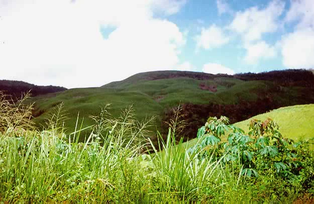
The landscape of Tirgua National Park is defined by piedmont topography along the transition between the central Venezuelan llanos and the foothills of the northern ranges. The terrain is uneven and broken, with irregular relief that creates a varied surface of slopes, valleys, and drainage lines.

This foothill setting shapes how water moves through the park, concentrating runoff into the streams and rivers that rise within its boundaries. The Tirgua River, the park's namesake, traces its origins to this system of slopes and seasonal forest cover, which together regulate the flow and quality of water in the broader region.

The park does not feature extreme elevations or dramatic high-mountain scenery. Instead, it offers a more rolling but accidented landscape, typical of Venezuelan piedmont environments, where changes in elevation, soil, and drainage create distinct microhabitats across a relatively compact geographic area.

Tirgua National Park ecosystems, habitats, and plant life

Ecologically, Tirgua National Park lies in a transitional zone between the dry interior landscapes of central Venezuela and the more humid northern foothills. This position gives it a vegetation mosaic shaped by seasonal rainfall patterns, with deciduous and semi-deciduous forests forming the dominant plant cover.

The tree canopy includes clusiaceous, mimosaceous, myrtaceous, and tiliaceous species, while the understory is occupied in large areas by palms. This mix of seasonal broadleaf forest and palm-dominated understory layers is characteristic of the region's piedmont forests, which shed leaves during the dry season and regain density with the rains.

The combination of varied topography, seasonal forest, and consistent water availability creates a habitat structure that supports a wide range of animals, making the park ecologically richer than its relatively modest size might suggest.

Tirgua National Park wildlife and species highlights

Tirgua National Park supports a diverse mammal community for an area of its size. Among the notable species are howler monkeys and capuchin monkeys, the cunaguaro (a wild cat of the region), the lapa (agouti), and the danta (tapir), a large herbivore of particular conservation interest.

Reptiles are also well represented, including snakes such as the boa constrictor (known locally as tragavenado), the mapanare, and several coral snake species. These reptiles occupy the forest understory and the edges of clearings and watercourses that cross the park.

The park is especially notable for its birdlife, with more than three hundred recorded species. Among them are the maracaná macaw (Ara severus), various parakeets and parrots, herons, two species of toucans, and many additional resident and migratory birds. This diversity makes the area meaningful for birdwatching and for regional avian conservation.

Tirgua National Park conservation status and protection priorities

Tirgua National Park's conservation value is rooted primarily in its hydrological function. By protecting the headwaters of the Tirgua River and the surrounding drainage basins, the park safeguards water supply, flow regulation, and watershed integrity for downstream communities and ecosystems.

Designated under IUCN Category II and managed by INPARQUES, the park forms part of Venezuela's national strategy for conserving representative ecosystems and critical water-producing landscapes. Its forested slopes act as natural regulators of rainfall capture and runoff, reducing erosion and maintaining water quality.

Beyond water, the park contributes to biodiversity conservation in north-central Venezuela by preserving seasonal piedmont forests and the fauna they support. The presence of species such as the tapir, several primate species, and a rich avifauna underscores the importance of maintaining habitat continuity in this transitional landscape between the llanos and the northern ranges.

Top sights and standout views in Tirgua National Park

Tirgua National Park's strongest defining feature is its role as a protected watershed surrounding the headwaters of the Tirgua River. This hydrological identity, more than any single landmark, gives the park its character and importance within the regional landscape.

Its varied foothill terrain, dominated by deciduous and semi-deciduous forests, supports an unusually rich fauna for the area, including primates, large cats, tapirs, snakes, and more than three hundred bird species. Together, these qualities make Tirgua a quiet but ecologically meaningful part of Venezuela's protected-area network.

Best time to visit Tirgua National Park

Tirgua National Park lies in a region with a pronounced seasonal climate, where the alternation between wet and dry periods strongly shapes the experience of the landscape. The dry season tends to bring more open forest conditions, easier visibility along forest edges and watercourses, and more concentrated wildlife activity around remaining water sources.

The wet season restores dense foliage and stream flow, which can make birdwatching and forest exploration more immersive, though tracks and trails may be more difficult to traverse. Because the park's appeal is strongly tied to its water systems and seasonal forests, understanding the local climate rhythm is more useful than focusing on a single calendar window.
Monthly climate preview

Long term representative temperature and monthly precipitation averages

Parque Nacional Tirgua Climate Normals and Annual Weather Patterns

Long term climate data for Parque Nacional Tirgua records measured mean temperatures between twenty four and twenty six degrees Celsius alongside distinct monthly precipitation variations. Examining the complete twelve month profile provides deeper insight into historical meteorological normals at the representative elevation point.
Annual mean25 °C
24 °C26 °C
Jan24°
Feb25°
Mar26°
Apr26°
May26°
Jun25°
Jul24°
Aug24°
Sep25°
Oct25°
Nov25°
Dec24°
Warmest month
April

26.2 °C

Coolest month
July

24.3 °C

Wettest month
July

4.2 mm/day

Driest month
February

0.5 mm/day

Park location guide

Geography guide, regional context, and park location map for Tirgua National Park

Tirgua National Park park geography, regions, and map view in Venezuela

Understand where Tirgua National Park sits in Venezuela through a broader geographic reading of the surrounding landscape, nearby location context, and its mapped position within the national park landscape.

How Tirgua National Park fits into Venezuela

Venezuela is a country in northern South America with coastline along the Caribbean Sea and Atlantic Ocean. It borders Colombia, Brazil, Guyana, and Trinidad and Tobago. The country has an area of approximately 916,445 km² and a population of about 31.8 million. Caracas is the capital and largest city. Venezuela consists of 23 states and the Capital District.

Wider geography shaping Tirgua National Park in Venezuela

Venezuela is located on the northern coast of South America. The continental territory is bordered by the Caribbean Sea and Atlantic Ocean to the north, Colombia to the west, Brazil to the south, and Guyana to the east. Trinidad and Tobago lies to the northeast. The country includes various islands and islets in the Caribbean Sea known as the Federal Dependencies.

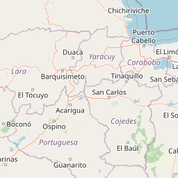
Map view of Tirgua National Park

Use this park location map to pinpoint Tirgua National Park in Venezuela, understand its exact geographic position, and read its mapped placement within the surrounding landscape more clearly.

Pigeon | © OpenStreetMap contributors

Location context for Tirgua National Park

CojedesYaracuy
Park atlas

Compare adjacent foothill terrain and regional watershed zones

Parks Near Parque Nacional Tirgua and Surrounding Protected Areas

Browse nearby national parks and protected areas sharing the piedmont geography of Parque Nacional Tirgua. Compare adjacent forest reserves and regional watershed landscapes across the surrounding transition zone.
National parkVenezuela
About 1.6 km away#1 closest

South

Tirgua National Park: Geographic Overview and Protected Mountain Landscape Map

Examining the high altitude terrain and watersheds of Lara State

Tirgua National Park is a protected area situated in the mountainous region of Lara State in western Venezuela. This location covers diverse cloud forest environments and steep river valleys that are critical to the Tocuyo River basin. The area provides a unique window into the neotropical mountain ecosystems of the Venezuelan Andes, showcasing rugged topography and distinct highland watersheds.

IUCN
II
Scope
Terrestrial
National parkVenezuela
About 66 km away#2 closest

West

Terepaima National Park: Venezuela's National Park Protected Landscape

Mapped Boundaries and Regional Geography

Terepaima National Park is a designated national park within Venezuela, offering a clear focus for atlas-driven exploration of protected natural areas. This entry highlights the park's significance as a mapped protected landscape, providing essential geographic context and detail for understanding its boundaries and regional setting. It is an integral component for any structured discovery of Venezuela's conservation network.

Area
186.5 km²
Established
1976
IUCN
II
Relief
Mountain
National parkVenezuela
About 67 km away#3 closest

North

Yurubí National Park: A National Park in Venezuela for Protected Landscape Exploration

Explore mapped boundaries and regional geography.

Yurubí National Park represents a distinct protected area within Venezuela, offering valuable data for geographic exploration and atlas-based understanding. This national park's identity is defined by its mapped boundaries and its role in the regional landscape context of northern South America. Delve into its protected territory to gain insights into Venezuela's natural geography and conservation landscapes.

Area
236.7 km²
Established
1960
IUCN
II
Relief
Mountain
National parkCarabobo
About 95 km away#4 closest

Northeast

San Esteban National Park: Discover Carabobo's Protected Caribbean Forest Landscape

Mapped protected area and natural terrain in Venezuela.

San Esteban National Park represents a significant protected area within Venezuela's Carabobo region, offering a unique exploration of Caribbean forest ecosystems and historical cultural sites. Covering approximately 445 square kilometers, the park's terrain spans coastal areas to mountainous interiors, presenting a diverse natural landscape shaped by its position in the coastal mountain ranges. This national park is notable for its archaeological petroglyphs, colonial roads, and fortifications, providing a rich cultural heritage context alongside its natural ecosystems. Its status as a protected national park makes it a key destination for understanding the intersection of natural conservation and historical geography in Venezuela.

Area
445 km²
Established
1987
IUCN
II
Relief
Mixed relief
National parkLara State
About 98 km away#5 closest

West

Cerro Saroche National Park: A National Park within Lara State's Geography

Explore the protected landscape and mapped boundaries.

Cerro Saroche National Park in Lara State, Venezuela, is a distinct protected area offering a valuable perspective for geographic and atlas exploration. This page provides essential details about its identity as a national park, highlighting its place within the regional landscape. Understanding Cerro Saroche National Park helps in appreciating the distribution of protected lands and their geographical significance across Venezuela.

Area
322.94 km²
Established
1989
IUCN
II
Relief
Mountain
Watercolor painting depicting mountains, a lake, and green vegetation
National parkVenezuela
About 101 km away#6 closest

Northeast

Henri Pittier National Park: Venezuela's Oldest National Park, Coastal Range Geography

Explore protected landscapes, cloud forests, and birdwatching geography.

Henri Pittier National Park is Venezuela's foundational protected area, established in 1937 and spanning over 107,800 hectares within the Venezuelan Coastal Range. This national park is renowned for its exceptional biodiversity, particularly its over 500 bird species and its distinctive cloud forest ecosystems, which include the iconic Gyranthera caribensis tree. The park's geography extends from rugged mountain terrain to coastal bays and beaches, with the Paso de Portachuelo serving as a significant migratory bird corridor. Its mapped boundaries enclose a rich mosaic of natural landscapes vital for understanding regional conservation and protected area geography in northern South America.

Area
1,078 km²
Established
1937
IUCN
II
Relief
Mountain
National parkVenezuela
About 102 km away#7 closest

West

El Guache National Park: Venezuela's Protected Andean Foothill National Park

Map exploration of vital river basins and natural landscapes.

El Guache National Park is a protected national park in Venezuela, safeguarding the headwaters of five key rivers. Its landscape comprises mountainous terrain within the Andean foothills, crucial for watershed protection and regional biodiversity. This entry provides detailed geographic context, allowing for an atlas-style exploration of the park's mapped boundaries and its role as a vital protected area.

Area
122 km²
Established
1992
IUCN
II
Relief
Mountain
National parkVenezuela
About 103 km away#8 closest

North

Morrocoy National Park: Venezuela's Coastal National Park with Distinct Protected Geography

Explore the mapped protected landscape and regional context.

Morrocoy National Park stands as a key protected area within Venezuela, offering a distinct focus for geographic exploration. As a national park, its mapped boundaries delineate a significant natural landscape critical for understanding regional conservation and the country's broader atlas of protected lands. Discover the unique geographic characteristics and the atlas-driven context of this important Venezuelan protected area.

Area
320.9 km²
Established
1974
IUCN
II
Relief
Mixed relief

Common questions about visiting, size, designation, and location context for Tirgua National Park

Tirgua National Park FAQs for park facts, access, geography, and protected area context

Find quick answers about Tirgua National Park, including protected-area facts, park geography, trail and visitor context, and how the park fits into its surrounding country and regional landscape.
MoriAtlas Explorer

Continue Your Protected Areas Search Across the Global Atlas

Deepen your exploration by continuing the structured search for national parks and protected areas worldwide. Utilize the comprehensive filtering capabilities to compare different conservation landscapes and refine your understanding of global park geography. Discover more about the distribution and characteristics of protected natural areas.

Global natural geography