Mori Atlas logo
Biosphere reserveTrifinio Biosphere Reserve

Mapping the Montecristo massif and the unique tri-national protected landscapes within Chiquimula Department

Trifinio Biosphere Reserve: Analyzing the Transboundary Cloud Forest and Mountainous Geography of Southeastern Guatemala

Trifinio Biosphere Reserve protects the Guatemalan portion of the Montecristo massif, a dense cloud forest landscape defined by towering oak and laurel trees. This mountainous terrain within Chiquimula Department anchors a critical transboundary ecosystem where national borders converge. Through this atlas view, examine the ecological boundaries, highland topography, and regional significance of this pioneering conservation corridor in Central America.

cloud forestbiosphere reservetransboundary conservationtri-national parkmontecristo massifhighland forest

Trifinio Biosphere Reserve

Biosphere reserve

Park overview

Structured park overview, official facts, and landscape profile for Trifinio Biosphere Reserve

Trifinio Biosphere Reserve park facts, protected area profile, and essential visitor context

Review the core facts for Trifinio Biosphere Reserve, including designation, size, terrain, visitor scale, habitats, and operating context in one park-focused overview.

About Trifinio Biosphere Reserve

The Trifinio Biosphere Reserve sits in the highlands of southeastern Guatemala, in a remote and scenic corner of the Chiquimula Department where the country's border meets those of Honduras and El Salvador. This tripoint has shaped the region's identity for centuries, but it became especially significant in the late twentieth century when the three neighboring countries recognized that the ecological value of the landscape demanded coordinated protection.

The reserve's defining feature is the Montecristo massif, a mountainous formation whose slopes are blanketed in cloud forest. The cool, persistent moisture of this cloud forest environment allows oak and laurel trees to grow to impressive heights, forming a dense canopy that shelters an unusually rich array of wildlife for such a relatively compact area. The reserve captures the Guatemalan side of this massif, complementing protected areas that Honduras and El Salvador later established on their own portions of the same mountain.

As a biosphere reserve operating under IUCN Category VI, the Trifinio area balances strict ecological protection with sustainable human activity, reflecting the reality that the region has long been home to agricultural communities and other land uses. The reserve is therefore not only a refuge for wildlife but also a working landscape where conservation and human presence must be reconciled.

Beyond its ecological role, the reserve represents one of Central America's most prominent examples of cross-border cooperation. Its designation in 1987 laid the foundation for what would eventually become the Trifinio Fraternidad Transboundary Biosphere Reserve, a recognition that the forests, water, and wildlife of the Montecristo range do not respect national boundaries.

Quick facts and research context for Trifinio Biosphere Reserve

The Trifinio Biosphere Reserve is a Guatemalan protected area in the Chiquimula Department, situated at the tripoint where Guatemala, El Salvador, and Honduras converge. Covering roughly 221 square kilometers, it was designated in 1987 and is managed under the country's national conservation framework with support from multiple governmental bodies.

The reserve falls within IUCN Category VI, a designation reserved for protected areas with sustainable use of natural resources, recognizing both its conservation value and the continued presence of local communities using the landscape. It constitutes the Guatemalan portion of the Trifinio Fraternidad Transboundary Biosphere Reserve, linking it ecologically and legally with protected areas across the border.

Protection and recognition

Documented terrestrial protection history, designation year, and transboundary scope

Trifinio Biosphere Reserve Protection Status and International Recognition Data

Trifinio Biosphere Reserve maintains documented terrestrial protection status established in 1987 across a transboundary protected area framework. Structured records outline the official designation history and management scope associated with the conservation landscape.

Protection details

Protection scope
Terrestrial
Designated year
1987
Transboundary protection
Yes
Park context

Deeper park guide and search-rich context for Trifinio Biosphere Reserve

Trifinio Biosphere Reserve history, landscape, wildlife, and travel context

Explore Trifinio Biosphere Reserve through its history, landscape character, ecosystems, wildlife, conservation priorities, cultural context, and seasonal travel timing in a structured park guide built for atlas discovery and search intent.

Why Trifinio Biosphere Reserve stands out

The Trifinio Biosphere Reserve is best known for protecting the Guatemalan portion of the Montecristo massif, one of the most important cloud forest strongholds in Central America. Its mist-cloaked oak and laurel forests rise through elevations that support a distinctive assemblage of highland wildlife, including anteaters, spider monkeys, pumas, and a rich variety of birds such as striped owls and toucans. The reserve is also recognized as a flagship example of tri-national conservation, where Guatemala, Honduras, and El Salvador coordinate protection of a single mountain ecosystem across political boundaries. The convergence of cloud forest habitat, transboundary governance, and the cultural geography of the Trifinio borderlands gives the area a distinctive identity within Guatemala's network of protected natural areas.

Trifinio Biosphere Reserve history and protected-area timeline

The Trifinio Biosphere Reserve was formally designated in 1987, emerging from a broader policy effort to protect the Montecristo massif across the borders of Guatemala, Honduras, and El Salvador. The same year saw the creation of Honduras's Montecristo Trifinio National Park, marking the beginning of coordinated tri-national conservation in the region.

Guatemala's reserve was the first formal protection established for this shared landscape, and it set the template for later cross-border cooperation. El Salvador followed in 2008 with the designation of its own Montecristo National Park, and the three countries jointly established the larger Trifinio Fraternidad Transboundary Biosphere Reserve in 2011, elevating the area's profile within international conservation frameworks.

The reserve's creation was also tied to the Trifinio plan, a regional development strategy aimed at improving conditions in this geographically remote border area while safeguarding its environmental assets. This dual focus on conservation and development helped shape the reserve's management approach, emphasizing sustainable use alongside strict protection of the most ecologically sensitive zones.

Trifinio Biosphere Reserve landscape and geographic character

The reserve's landscape is defined by the Montecristo massif, a forested mountain range whose slopes form part of the northern highlands of Central America. The terrain rises through forested ridges and valleys, with elevation changes that create the cool, humid conditions necessary for cloud forest to thrive.

Persistent cloud cover and mist are central to the character of the landscape, blanketing the canopy and feeding the soils that support the massive oak and laurel trees. The forest's density gives the mountains a deeply forested, near-primordial appearance, with tree heights reaching around 30 meters in the most undisturbed stands. From the ridgelines, the landscape opens onto views that span the political borders of three countries, a reality that defines both the ecology and the geography of the reserve.

Trifinio Biosphere Reserve ecosystems, habitats, and plant life

The ecological identity of the Trifinio Biosphere Reserve is rooted in cloud forest, a globally threatened and biologically rich ecosystem type. The reserve's oak and laurel forests form a multilayered canopy, with emergents towering above a dense understory that retains moisture from the nearly constant mist.

This combination of elevation, humidity, and forest cover creates habitat conditions that support a remarkable diversity of plants and animals. The reserve's ecosystems are among the most important cloud forest remnants in northern Central America, and they function as a refuge for species that depend on the cool, moist microclimate that the massif provides.

Because the reserve lies within a sustainable-use category, its natural systems coexist with human land use on the landscape's periphery, making the cloud forest core an especially vital refuge for biodiversity in the broader region.

Trifinio Biosphere Reserve wildlife and species highlights

The cloud forests of the Trifinio Biosphere Reserve support a diverse array of Central American highland wildlife. Mammals of conservation interest include the two-fingered anteater, Central American agouti, puma, and spider monkey, each reflecting the health of the forested massif that the reserve protects.

Birdlife in the reserve is notable for its forest-dwelling species, and the canopy and mid-level forest provide habitat for toucans and striped owls among other characteristic cloud forest birds. The presence of apex predators and primates indicates that the reserve's forest retains the structural complexity needed to support larger species, not only small or edge-adapted wildlife.

While the available documentation highlights only a subset of the species present, the wildlife profile of the reserve is consistent with that of a high-quality Central American cloud forest complex, where rare mammals and a rich bird community persist alongside one another in the misty uplands.

Trifinio Biosphere Reserve conservation status and protection priorities

The Trifinio Biosphere Reserve plays an important role in conserving the Montecristo massif, one of the more significant cloud forest complexes in northern Central America. Its designation in 1987 helped anchor a transboundary approach that has since grown into a coordinated tri-national conservation framework.

The reserve's IUCN Category VI status reflects a model of conservation that pairs strict protection of sensitive ecological zones with sustainable use across broader areas of the landscape. This approach acknowledges that the surrounding region remains inhabited and economically active, and that long-term conservation depends on aligning protection with the needs of local communities.

By serving as the Guatemalan anchor of the Trifinio Fraternidad Transboundary Biosphere Reserve, the area contributes to the integrity of a much larger regional conservation network. Its protection helps maintain the cloud forest's role as a refuge for rare species, a source of fresh water for downstream areas, and a cornerstone of cross-border ecological cooperation in Central America.

Top sights and standout views in Trifinio Biosphere Reserve

The Trifinio Biosphere Reserve's most distinctive features are its towering cloud forests of oak and laurel, the tri-national geography at the heart of its identity, and its role as a pioneering example of cross-border conservation in Central America. The reserve protects a portion of the Montecristo massif that remains remarkably intact, offering refuge for rare mammals and birds.

The area also stands out for its integration of conservation with regional development planning, a balance that has shaped the reserve's management since its creation as part of the broader Trifinio plan. Together, these qualities make the reserve not only an important ecological refuge but also a significant chapter in the story of Central American environmental cooperation.

Best time to visit Trifinio Biosphere Reserve

The cloud forest environment of the Montecristo massif is shaped by persistent humidity and cool temperatures, conditions that favor the reserve's distinctive ecosystems throughout the year. Visiting when mist and cloud cover settle over the canopy offers the most atmospheric experience of the landscape, while clearer periods can open long-distance views across the tripoint region where Guatemala, Honduras, and El Salvador meet.

Seasonal changes in rainfall patterns affect access conditions and the character of the forest, with generally drier months typically associated with better ground conditions for forest exploration. The cooler climate of the highland cloud forest also means that visitors should be prepared for mild temperatures regardless of season, in contrast to Guatemala's hotter lowlands.

Monthly climate preview

Track representative annual temperature ranges and precipitation patterns across twelve months.

Trifinio Biosphere Reserve Climate and Long-Term Monthly Weather Normals

Trifinio Biosphere Reserve records measured monthly mean temperatures spanning from 19.95 to 25.21 degrees Celsius alongside varying daily precipitation rates. Examining the full climate profile reveals detailed twelve-month temperature extremes and precipitation averages derived from historical coordinate data.
Annual mean22 °C
20 °C25 °C
Jan20°
Feb22°
Mar23°
Apr25°
May25°
Jun23°
Jul23°
Aug23°
Sep22°
Oct22°
Nov20°
Dec20°
Warmest month
April

25.2 °C

Coolest month
December

20 °C

Wettest month
September

6.4 mm/day

Driest month
March

0.5 mm/day

Park location guide

Geography guide, regional context, and park location map for Trifinio Biosphere Reserve

Trifinio Biosphere Reserve park geography, regions, and map view in Guatemala

Understand where Trifinio Biosphere Reserve sits in Guatemala through a broader geographic reading of the surrounding landscape, nearby location context, and its mapped position within the national park landscape.

How Trifinio Biosphere Reserve fits into Guatemala

Guatemala is a presidential republic in Central America with a population of approximately 18.6 million, making it the most populous country in the region. The country was the heartland of the Maya civilization and gained independence from Spain in 1821. Guatemala has a diverse population including Maya, Ladino, Xinca, and Afro-Guatemalan communities, with Spanish as the official language.

Wider geography shaping Trifinio Biosphere Reserve in Guatemala

Guatemala is located in northern Central America, bordered by Mexico to the north and west, Belize to the northeast, Honduras to the east, El Salvador to the southeast, and the Pacific Ocean to the south. The terrain is predominantly mountainous with highlands, volcanic ranges, and coastal lowlands. The country includes the Petén region, a large lowland jungle area in the north.

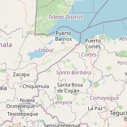
Map view of Trifinio Biosphere Reserve

Use this park location map to pinpoint Trifinio Biosphere Reserve in Guatemala, understand its exact geographic position, and read its mapped placement within the surrounding landscape more clearly.

Pigeon | © OpenStreetMap contributors

Location context for Trifinio Biosphere Reserve

Chiquimula Department
Park atlas

Explore surrounding borderland reserves and highland mountain habitats

Parks Near Trifinio Biosphere Reserve And Connected Protected Landscapes

Compare Trifinio Biosphere Reserve with adjacent protected areas across the Montecristo massif and surrounding borderlands. Expanding the geographic scope reveals how regional conservation networks link diverse highland ecosystems and cloud forest habitats.
National parkHonduras
About 0 km away#1 closest

Northeast

Montecristo Trifinio National Park: Honduras National Park and Protected Landscape Atlas

Explore its mapped boundaries and regional geographic context.

Delve into the protected landscape of Montecristo Trifinio National Park, a designated national park within Honduras. This resource provides critical atlas-level information, detailing the park's geographic scope, mapped boundaries, and its significance as a protected natural area. Understand the terrain and landscape context to appreciate its unique role in the region's conservation framework and its place within the structured exploration of national parks.

Area
54 km²
Established
1987
IUCN
II
Relief
Mountain
National parkEl Salvador
About 4 km away#2 closest

Northeast

Montecristo National Park: El Salvador's Protected Landscape and Geographic Identity

Explore its mapped boundaries and regional terrain.

Montecristo National Park is a vital protected area that anchors a specific geographic identity within El Salvador. This MoriAtlas entry provides an atlas-driven view of the park, highlighting its mapped boundaries and the characteristics of its natural terrain. Understanding Montecristo National Park's protected status offers insight into the region's geography and its place within Central America's broader landscape.

Area
19.73 km²
Established
2008
IUCN
II
Relief
Mixed relief
National parkLempira Department
About 61 km away#3 closest

East

Celaque National Park: Mapped Protected Landscape within Lempira Department

National Park Protected Area & Geographic Context

Celaque National Park represents a key protected landscape situated in the Lempira Department of Honduras. This entry offers detailed atlas information, focusing on the park's identity as a national park and its mapped geographic extent. Users can explore the protected boundaries and understand its place within the regional terrain, providing essential context for geographic discovery.

Area
266.31 km²
Established
1987
IUCN
II
Relief
Mountain
National parkEl Salvador
About 72 km away#4 closest

Southwest

Los Volcanes National Park: Exploring El Salvador's Volcanic Terrain and National Park Boundaries

Mapped protected lands and regional geography.

Los Volcanes National Park is a protected natural area situated within El Salvador's geographically rich landscape, known for its volcanic terrain. This page provides an atlas-focused view of the park, highlighting its mapped boundaries and its context within the Central American region. Engage with structured geographic data to understand the protected land and its surrounding terrain.

IUCN
II
Relief
Mountain
Scope
Terrestrial
Water
Minor water
National parkEl Salvador
About 77 km away#5 closest

South

El Boquerón National Park: National Park Atlas, Mapped Boundaries, and Regional Geography

Explore El Salvador's protected volcanic terrain and landscape.

Delve into the protected landscape of El Boquerón National Park, a significant national park in El Salvador. This resource provides detailed map context, focusing on the park's geographic boundaries and its position within the country's volcanic region. Understand the atlas-driven discovery value and unique regional setting of this protected area.

Area
2.05 km²
Established
2008
IUCN
II
Relief
Mountain
National parkHonduras
About 81 km away#6 closest

Northeast

Cerro Azul de Copán National Park: Honduras's Highland Cloud Forest Protected Area

Explore mapped geography and montane landscape context.

Cerro Azul de Copán National Park, located in the highlands of western Honduras, is a national park defined by its mountainous terrain and distinctive cloud forest environment. Rising to elevations of over 2,200 meters, the park preserves a crucial highland ecosystem known for its biodiversity and role in watershed protection. Its mapped geography offers insight into the unique montane forest structures and the broader natural landscape of Central America. Discover the protected land's specific environmental characteristics and its place within the region's atlas.

Area
154.6 km²
Established
1987
IUCN
II
Relief
Mountain
Stylized illustration of a mountain valley with waterfall, dense forest, and trees
National parkAhuachapán Department
About 91 km away#7 closest

Southwest

El Imposible National Park: National Park Protected Landscape and Regional Geography Exploration

Atlas context and mapped boundaries for El Imposible National Park.

Delve into the protected landscape of El Imposible National Park, a key national park located within Ahuachapán Department, El Salvador. This resource provides detailed information on its geographic setting, mapped park boundaries, and its role within the regional natural context. Understand the essence of this protected natural area through structured atlas data, offering a unique lens for exploring its conservation significance and landscape features.

Area
38.2 km²
Established
1989
IUCN
II
Relief
Mountain
National parkGuatemala
About 135 km away#8 closest

West

Naciones Unidas National Park: Guatemala's National Park Geographic Identity

Explore protected landscape and mapped terrain within Guatemala.

Naciones Unidas National Park represents a key protected area within Guatemala, offering a distinct geographic identity for atlas exploration. This page focuses on its mapped boundaries and its significance as a national park, providing insight into its landscape context and regional setting. Users can delve into its specific geography for structured understanding of protected natural areas.

Area
4.91 km²
Established
1955
IUCN
II
Relief
Mixed relief

Common questions about visiting, size, designation, and location context for Trifinio Biosphere Reserve

Trifinio Biosphere Reserve FAQs for park facts, access, geography, and protected area context

Find quick answers about Trifinio Biosphere Reserve, including protected-area facts, park geography, trail and visitor context, and how the park fits into its surrounding country and regional landscape.
MoriAtlas Explorer

Continue Your Protected Areas Search Across the Global Atlas

Deepen your exploration by continuing the structured search for national parks and protected areas worldwide. Utilize the comprehensive filtering capabilities to compare different conservation landscapes and refine your understanding of global park geography. Discover more about the distribution and characteristics of protected natural areas.

Global natural geography